
Maps of the Ancient Sea Kings;
Evidence of Advanced Civilization in the Ice Age
by Dr. Charles Hapgood
Reviewed by Dan Glover 3/3/99
This book gives compelling evidence that there existed advanced civilizations prior to any that we are now aware of. Scholars have long dismissed legends and myths of such civilizations as mere story-telling and embellishment by our ancestors. Dr. Charles Hapgood studied what he considered copies of ancient maps and came to some very startling conclusions. In 1929, a map was found, painted on parchment, and dated in the month of Murharrem in the Muslim calendar year 919, which is 1513 by the Christian calendar. This map was signed with the name Piri Ibri Haji Memmed, a Turkish admiral ("Re'is") and became known as the Piri Re'is map.
The map aroused interest because it appeared to be one of the earliest maps of the Americas. Examination showed that this map differed significantly from all other maps of America drawn in the 16th century in that it showed South America and Africa in correct relative longitudes. This was remarkable because navigators in the 16th century had no means of finding longitude except by guesswork. Another detail excited researchers as well. In one of the legends inscribed on the map, Piri Re'is stated that he based the western part of it on a map drawn by Christopher Columbus. This was very exciting, as for several centuries geographers had been trying without success to find a "lost map of Columbus" supposed to have been drawn by him in the West Indies.
Piri Re'is made several interesting statements about his source maps. He used about twenty, he said, and stated that several had been drawn in the time of Alexander the Great. Scholars who studied the map in the 1930s could prove neither statement, but it appears now that both statements were true. After a time, scholars lost interest in the map and it was not accepted as a map by Columbus. No more was heard of the map until 1956, when a Turkish naval officer brought a copy of the map to the U.S. Navy Hydrographic Office as a gift. The map was referred to a cartographer on the staff, M. I. Walters.
Walters happened to show the map to a friend, Captain Arlington H. Mallery, a student of old maps and a breaker of new ground in borderline regions of archaeology. Mallery took the map home to study, and returned with some surprising comments. He made the statement that the map, in his opinion, showed bays and islands off the Antarctic coast of Queen Maud Land now under the ice cap. This would imply that somebody mapped the coast before the ice cap had appeared. This statement was too radical to be taken seriously by most professional geographers, but Walters felt Mallery might be right.
Mallery called on others to examine his findings. These included the Rev. Daniel L. Linehan, director of the Weston Observatory of Boston College and the Rev. Francis Heyden, director of the Georgetown University Observatory. Linehan and Mallery took part in a radio panel discussion on August 26, 1956, and verbatim copies of this broadcast were distributed and brought to the attention of Charles Hapgood. He was impressed with the confidence placed in Mallery by men like Walters, Linehan and Heyden and had a strong hunch that, despite the improbability and lack of proof (at that time), Mallery might well be right.
Hapgood was then teaching at Keene State College, and decided to undertake an investigation of the Piri Re'is map as thoroughly as he could. It had always been Hapgood's habit to involve his students in problems on the frontiers of knowledge, for he believed that unsolved problems provided better stimulation for intelligence and imagination than did already solved problems from textbooks. Hapgood also believed that the amateur had a much larger role in science than usually recognized, and was aware that most radical discoveries were opposed by the experts in the affected fields. The specialist who starts out by learning what everybody else knows is not very likely to initiate anything new. An expert knows everything important, and if the expert doesn't know everything important, at least they know more than most other people, and believes that amateurs know nothing. An unwise contempt for amateurs arises, despite the fact that it is the amateur who has made innumerable discoveries in all fields of science.
In chapter two, Hapgood writes:
When our investigation started my students and I were amateurs together. My only advantage over them was that I had had more experience in scientific investigations; their advantage over me was that they knew even less and therefore had no biases to overcome. At the very beginning I had an idea - a bias, if you like - that might have doomed our voyage of discovery before it started. If this map was a copy of some very ancient map that had somehow survived in Constantinople to fall into the hands of the Turks, as I believed, then there ought to be very little resemblance between this map and the maps that circulated in Europe in the Middle Ages. I could not see how this map could be both an ancient map (recopied) and a medieval one. Therefore, when one of my students said this map resembled the navigation charts of the Middle Ages, at first I was not much interested. Fortunately for me, I kept my opinions to myself, and encouraged the students to begin the investigation along that line. [1]They soon accumulated considerable information about medieval maps. They were not concerned with land maps, which were exceedingly crude, but only in sea charts used by medieval sailors from about the 14th century on. These "portolan" maps were of the Mediterranean and Black Seas, and they were good. The reader of this review may compare for themselves. Figure 1 below is a typical medieval land map, while figure 2 is a sea chart of the Mediterranean Sea from the year 1339.
For example, Hapgood and his students discovered that one of the leading scholars in the field did not believe the charts originated in the Middle Ages. A. E. Nordenskiöld, who compiled an atlas of these charts (which Hapgood and his students used) also wrote an essay on their history, presenting several reasons for concluding they must have come from ancient times. In the first place, he pointed out that the Dulcert Portolano and others like it were a great deal too accurate to have been drawn by medieval sailors. Then there was the curious fact that successive charts showed no signs of development. Those from the beginning of the 14th century were as good as those from the 16th. It seemed as though someone early in the 14th century had found an amazingly good chart which no one was able to improve upon for two hundred years. Furthermore, Nordenskiöld saw evidence that only one such model had been found, and that all other portolanos drawn in the following centuries were copies from that original.
Nordenskiöld was familiar with the maps of Claudius Ptolemy, which had survived from antiquity and had been reintroduced to Europe in the 15th century. Comparing the maps, he found that the portolanos were much better than Ptolemy's maps. Comparing Ptolemy's map of the Mediterranean and the Black Sea with the Dulcert Portolano below in Figure 3, the older map's superiority is evident.

What could this mean? Ptolemy is the most famous geographer of the ancient world. He worked in Alexandria in the 2nd century A.D. in the greatest library of the ancient world. He had at his command all the accumulated geographical information of that world. He was aquainted with mathematics and showed in his great work, the Geographia, a modern mentality. Is it to be assumed that medieval sailors of the 14th century, without any of this knowledge, and without modern instruments except a rudimentary compass, could have produced a more scientific product?
Nordenskiöld felt that there had been in antiquity a geographic tradition superior to the one represented by Ptolemy. He felt that the portolano charts must have been in use then by sailors and navigators, and answered the objection that there was no mention of such maps by various classical writers by pointing out that in the Middle Ages, when the portolano charts were in use, they were never referred to by the Schoolmen, the academic scholars of that age. Both in ancient times and medieval times, sailors and academic scholars were apparently poles apart. Nordenskiöld was not able to offer an answer to the problem of where the portolanos came from, however. Neither the medieval navigators nor the known Greek geographers could have drawn them. The Arabs, famous for their scientific achievements of the Middle Ages, apparently could not have drawn them either. Their maps are less accurate than Ptolemy's. The evidence points to the origin of the portolanos in a culture with a higher level of technology than was obtained in medieval or ancient times.
A modern Arab geographer, Youssouf Kamal, opposed Nordenskiöld's viewpoint violently as he wrote:
Kamal also argued against the viewpoint that the lines on the portolanos were intended to facilitate navigation by the compass.Our incurable ignorance ... as to the origin of the portolanos or navigation charts known by this name, will lead us only from twilight into darkness. Everything that has been written on the history or the origin of these charts, and everything that will be said or written hereafter can be nothing but suppositions, arguments, hallucinations. [2]
As for the lines that we see intersecting each other, to form lozenges, or triangles, or squares: these same lines, I wish to say, dating from ancient Greek times, and going back to Timosthenes, or even earlier, were probably never drawn ... to give ... distances to the navigator. The makers of the portolanos preserved this method, that they borrowed from the ancient Greeks or others, more probably and rather to facilitate the task of drawing a map, rather than to guide the navigator with such divisions. [3]In other words, the portolano design was an excellent design to guide a map maker either in constructing an original map or in copying one. Early in Hapgood's investigation, three of his students decided to look into the purpose of these lines as their special project. They journeyed to Hanover, New Hampshire and inspected the medieval charts in the Dartmouth College Library. On their return, one student, Loren Livengood, said he thought he knew how the charts had been constructed.
The problem was to find out, from the lines found on the portolanos, whether or not it might be possible to construct a grid of lines of latitude and longitude such as is found on modern maps. In other words, the problem was to see if this portolano system could be converted to the modern map making system. Livengood's approach was simple. Without realizing the importance of his choice, he put himself in the position of map maker rather than navigator. That is, he saw the problem not as one of finding a harbor, but of actually constructing the map. Livengood had never heard of Kamal, but he was adopting the Prince's point of view of the purpose of the lines.
The probable procedure, Livengood speculated, was first to pick a convenient center for his map and then determine a radius long enough to cover the area being mapped. With this center and radius, the map maker would draw a circle.

Then the map maker would bisect the circle again and again until he had sixteen lines from the center to the periphery at equal angles of 22½º. These could be further bisected, resulting in thirty-two points on the periphery. The third step would be to connect points on the perimeter to make a square, with four different square possible. The fourth step would be to choose one of the squares, and draw lines connecting the opposite points, thus making a map grid of lines at right angles to each other.
Although scholars agreed that the portolan charts had no lines of latitude or longitude, it stood to reason that if one of the vertical lines was drawn to true north, then it would be a meridian of longitude, and any line at right angles to it would be a parallel of latitude. Assuming a projection such as the Mercator projection, in which all meridians and parallels are straight lines crossing at right angles, then all parallel vertical lines would be meridians of longitude and all horizontal lines would be parallels of latitude.
Comparing this idea to the Piri Re'is map, Livengood could see that the map maker had selected a center, which he had placed somewhere to the east of the torn edge of the fragment of the world map and had then drawn a circle around it. The map maker had bisected the circle four times, drawing 16 lines from the center to the perimeter, and he had also drawn in all four possible squares for drawing different grids for different parts of the map, where it might be necessary to have different norths. It was another student, Leo Estes, who pointed out the Piri Re'is map had the potentiality for several different norths on the same map.
Since the earth is round, and the portolan design apparently based on a flat surface projection which would not take account of the spherical surface, the meridians would deviate further and further from true north the farther they were removed from the center of the map. The portolan design would compensate for this. Estes also suggested a solution to finding which square was the right square to start with. Comparing the Piri Re'is map with a modern map, he found a meridian on the modern map that coincided very nearly with a line on the Piri Re'is map, about 20º W longitude close to the African coast. Estes suggested this line might be a prime meridian, a line drawn to true north. All lines parallel to this would be meridians of longitude, and all lines at right angles would be parallels of latitude. Hapgood writes:
As we identified more and more places on our grid, and averaged their errors in position, we found all over the map some common errors that indicated something was wrong with the projection. We concluded there must still be errors either in the location of the center of the map, or in the length of the radius, or both. ... We knew, of course, that our assumption that the map maker had precise knowledge of the size of the earth was doubtful. It was much more than likely that he had made some sort of mistake. We shortened the radius a few degrees, on the assumption that the map maker might have underestimated the size of the earth, as Ptolemy had. This only increased the errors. ... This error amounted to an error of 4½º. [4]With regard to overestimating the size of the earth, there was one ancient geographer who made an overestimate of this size. That was Eratosthenes. This didn't mean Eratosthenes was the map maker, because the Piri Re'is map was drawn from a source map originally drawn with plane trigonometry, which may not have been known in ancient Greece at the time of Eratosthenes. Supposedly it had been invented by Hipparchus, who lived about a century later. If Eratosthenes estimate of the size of the earth was used for copying the Piri Re'is source map, and if it was 4½º off, the positions found by trigonometry were somewhat in error in latitude and longitude. By redrawing the grid to correct for Eratosthenes error, all errors vanished on the Piri Re'is map.
This was quite a startling development for Hapgood and his students, for it could only mean that the Greek geographers of Alexandria had in front of them source maps that had been drawn without the Eratosthenian error. This suggested that the peoples who originated the maps possessed a more advanced science than that of the Greeks. It was obvious that the original maker of the map had observed their latitudes and longitudes extremely well. It also became apparent that those who originally copied the Piri Re'is map had used a different length for a degree of latitude than for a degree of longitude. In other words, the geographers who designed the square portolan grid for which Hapgood and his students discovered a trigonometric solution had apparently applied their projections to maps that had originally been drawn with another projection.
The Antarctic Maps of Oronteus Finaeus and Mercator
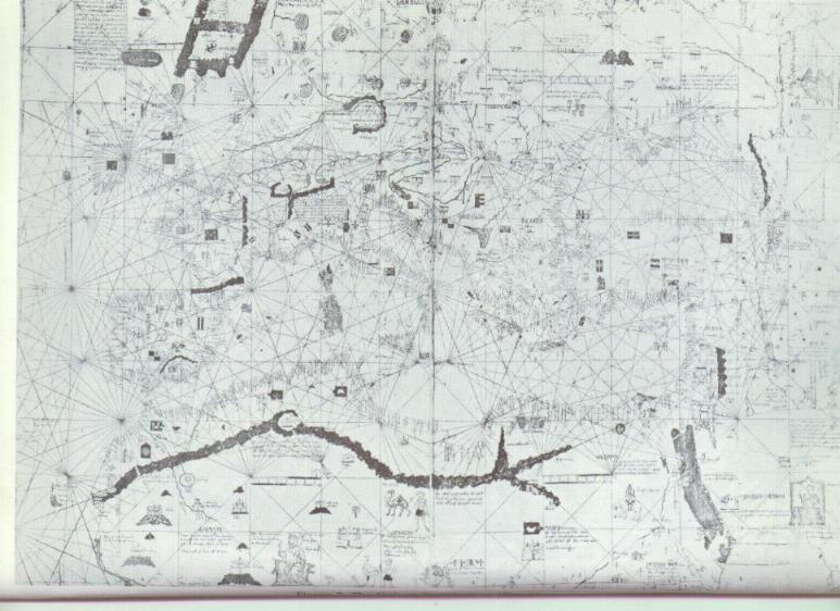
Part of the Piri Re'is investigation led Hapgood to search for other portolan charts from the Middle Ages that might show Antarctica. He arranged to spend some time at the Library of Congress in 1959, writing ahead and requesting that all old maps of the period in question be brought out and made ready for inspection. Somewhat to his consternation, upon arriving he discovered several hundred books of maps laid out on the conference tables in the reference room. Slowly working through them from morning until evening, he examined each one. One day he turned a page and his eyes fell on the southern hemisphere of a world map drawn by Oronteus Finaeus in 1531 and he knew he had found what he had been looking for. The general shape of the continent was startlingly like the outline of the continent on modern maps.

It was obvious to Hapgood that this was no creation of someone's imagination. The mountain ranges were individualized, some coastal and some not. Rivers were flowing from them into the sea in what looked like very natural and convincing drainage patterns. This suggested to Hapgood that the coast may have been free of ice at the time the original map was drawn, just as Captain Mallery had suggested about the Piri Re'is map. This was not only troubling in that the ice cap of Antarctica is supposedly millions of years old, but Antarctica itself was supposedly not discovered until the year 1818. These are no slight matters to be overlooked.
Another important fact from the Oronteus Finaeus map is that all the rivers on it are shown flowing from mountain ranges near the coast. No rivers are shown in the deep interior. This would suggest that when the source maps were made, the interior was already covered by the ice cap. In that case, the ice cap was an advancing continental glacier that had not yet brimmed the mountain ranges to reach the sea. Hapgood and his students concluded that the Oronteus Finaeus map was based on an authentic source map compiled from local maps before the ice cap had reached the coast of Antarctica.
A good many of the 16th century maps show a southern continent where
none exist. Gerhard
Kremer, a.k.a. Mercator, who lived in the 16th century, believed in
its existence. A comparison of all the versions suggested that there may
have been one or two original prototype maps, drawn according to different
projections, which were copied and recopied. The belief in the existence
of a southern continent lasted until the time of Captain Cook, who's voyages
in the south seas demonstrated the non existence of a southern continent,
at least in the latitude that appears on these maps.

In some respects, Hapgood found the Hadji Ahmed World Map of 1550 to be most remarkable. He found a striking difference in the drawing of the eastern and western hemispheres. The eastern hemisphere seemed to have been based on sources available to geographers of the time, mostly Ptolemy, and are somewhat ordinary. The map of the Mediterranean was apparently based on Ptolemy's maps as well, as was Africa. Neither compared favorably with the older, more accurate Piri Re'is map. But it is an entirely different story for the western hemisphere, and it soon became apparent that the map maker had at his disposal some most extraordinary source maps.
The shapes of North and South America have a surprisingly modern look, the west coast particularly interesting. They seemed to be about two centuries ahead of the cartography of the time. Furthermore, they appear to be drawn with highly sophisticated spherical projection. The shape of what is now the United States is just about perfect. It is very difficult to imagine how the map could have been drawn of the Pacific coast, with remarkable accuracy, in the middle of the 16th century, more than two hundred years before the solution to the problem of longitude.
Another remarkable detail of the map is the suggestion of a land bridge between Alaska and Siberia. Mr. Derek S. Allan, a British scientist from Oxford, commented on the maps: "It would seem, perhaps, that either the sea level was lower, or that the land has sunk since the original map was drawn. The Laptev sea area - including the New Siberian Islands? - appears as dry land (this may well be correct since the sea bottom today is the most extraordinary mammoth graveyard) and it seem that Novya Semlya was joined to the Siberian Coast. ... One might note with astonishment that there appears to be no indication of ice cover in the area."
A more detailed examination of the Hadji Ahmed map revealed further
interesting facts. The apparent exaggeration of the size of Antarctica
could perhaps be attributed to the same error found on the Oronteus Finaeus
map as mentioned above. But even considering this, the continent on this
map seemed much too large, and its shape is hardly recognizable. To consider
the cause of the extreme distortion, Hapgood and his students considered
the polar regions on a Mercator map and could not help but notice how it
exaggerated the northern regions. Hapgood and his students concluded that
the ancient source maps of Antarctica may have been drawn on a projection
resembling the Mercator, at least in this respect of having straight meridians
parallel to each other.

The Hamy-King Chart of 1502 was found to be based partly on Ptolemaic and partly on Portolano traditions, with recently discovered lands added by an early explorer, thought to be Amerigo Vespucci. The European section seemed to be based on the most accurate of the portolano charts. This world map provides evidence of numerous and extensive geological changes since the first prototypes of its original local maps were drawn. It was interesting to note that in placing the center of the portolano chart in the Indian Ocean, the cartographer made it possible to construct a world map embracing all of Europe, Asia, Africa and the Americas as well. It was a much broader design than found on the Piri Re'is map.
As already noted, the Hamy-King map was associated with the name of Vespucci. However, Hapgood and his students became convinced that, while the compilation of the map was undoubtedly Vespucci's, the actual drawing of it could not have been Vespucci's work. Vespucci claimed to be able to find longitude by astronomical observation. However, at one point he established his longitude at 150º west of the meridian at Alexandria, which would have put him in Santa Barbara, California, much further west than he ever traveled. This didn't say much of his method.
Examination of the Hamy-King map revealed two surprising facts. First, the originally separate Mediterranean map had been oriented to magnetic, and not to true north. The compiler had not understood this, and thus introduced an error into the map. Second, it is probable that the compilation of this separate portolano with the rest of the map was made after the introduction of the compass into Europe in the 13th century, for it was only after this that a magnetic orientation was applied to the charts.
The Geography of the Map
One of the greatest puzzles of the King-Hamy map is India. It is shown as a truncated peninsula, with a large land mass lying as an island to the south. Hapgood and his students considered the possibility good that this was not a result of bad cartography, but rather the influence of an ancient time when the plains of India were flooded and the southern part of the peninsula, ancient Dravidia, was an island. Because the mouths of the Ganges river, across the whole extent of India, was correctly placed, and that the map represents latitude and longitude fairly well, they proposed that Dravidia was perhaps the center of a great maritime civilization, and an advanced culture that was very old when Egypt was young. Also, there is geological evidence for the flooding of the northern plains of India, presented by A. K. Dey of the Geological Survey of India. In a paper entitled "The Shores of India", he followed elevated beaches into the interior as far north as the estuaries of the Indus. There is also literary evidence, traditions of ancient Indian literature, the Vedas, which tells of a time when Dravidia was an island.
There are additional suggestions of geological changes on the King-Hamy map. There is a vast extension southward of the Asian land mass, which interestingly, was also postulated by Alfred R. Wallace, co-discoverer of the theory of evolution. He studied the distribution of species in the islands of Indonesia and concluded there was much evidence for a very recent connection between Java, Sumatra, Borneo and the mainland of Australia. He also reported native traditions that placed this connection in the very recent past, only a few thousand years ago.
Hapgood also considered it highly likely that the Mediterranean portion of the map was originally drawn before the explosion of Thera about 1400 B.C. Finally, this portolano chart indicates many more rivers than exist today in Europe and North Africa. This seems to concur with the change of climate which is known actually occurred in fairly recent times.
Conclusions
The conclusions Hapgood drew are history shattering in their implications. The evidence presented by the maps he and his students studied indicate the existence of a civilization in remote times, well before the rise of any known civilization. In geodesy, nautical science and map making, it was more advanced than any civilization before the 18th century. In fact, it was not until the 19th century that our own civilization explored the Arctic and Antarctic, and the bottom of the Atlantic ocean. These ancient maps indicate that the makers did all these things.
Mapping on this scale suggests both economic motivations and economic
resources. Organized government is indicated. And certainly, the disappearance
of this civilization has implications that our own civilization should
consider carefully. Hapgood writes:
1) The idea of the simple linear development of society from the culture of the paleolithic (Old Stone Age) through the successive stages of the neolithic (New Stone Age), bronze, and iron ages must be given up. Today we find primitive cultures co-existing with advanced modern society on all the continents - the Bushmen of Australia, the Bushmen of South Africa, truly primitive peoples in South America, and in New Guinea; some tribal peoples in the United States. We shall assume now that, some 20,000 years or more ago, while paleolithic peoples held out in Europe, more advanced cultures existed elsewhere on the earth, and that we have inherited a part of what they once possessed, passed down from people to people.This ends the review. Thanks for reading! Any and all comments are appreciated!2) Every culture contains the seeds of its own disintegration. At every moment forces of progress and of decay co-exist, building up and tearing down. All too evidently the destructive forces have often gained the upper hand; witness such known cases as the extinctions of the high cultures of ancient Crete, Troy, Babylon, Greece and Rome, to which it would be easy to add twenty others. And, it is worth noting that Crete and Troy were long considered myths.
3) Every civilization seems eventually to develop a technology sufficent for its own destruction, and hitherto has made use of the same. There is nothing magical about this. As soon as men learn to build walls for defense, other men learned how to tear them down. The vaster the achievements of a civilization, the farther it spreads, the greater must be the engines of destruction; and so today, to counter the modern worldwide spread of civilization, we have atomic means to destroy all life on earth. Simple. Logical.
4) The more advanced the culture, the more easily it will be destroyed, and the less evidence will remain. Take New York. Suppose it was destroyed by a hydrogen bomb. After 2000 years, how much of its life could anthropologists reconstruct? Even if quite a few books survived, it would be quite impossible to reconstruct the mental life of New York. The sad story of destruction, whereby man destroys almost as much as he creates, does not start with our 20th century. Consider the question of libraries. The ancient worlds of Greece and Rome had many libraries. The most famous of these was Alexandria, founded in Egypt by Alexander the Great three centuries before the Christian era. Five hundred years later it was said to have contained about one million volumes, and into it was gathered the entire knowledge of the ancient western world. This library, the heritage of untold ages, was burned. [5]

[1] Maps of the Ancient Sea Kings, Charles Hapgood
[2] Hallucinations Scientifiques, Prince Youssouf Kamal
[3] Ibid.
[4] Maps of the Ancient Sea Kings, Charles Hapgood
[5] Ibid.
Links of Interest
The Piri Reis map and its mysteries
The Mysterious Origins of Man: The Oronteus Finaeus Map of 1532