OnLine

|
Pittsburgh Railways OnLine |
|

Geography has always played a significant role in the history of public transit in Pittsburgh. The relative ease with which buses, LRVs, and modern automobiles climb and descend the steep hills of the Steel City today belies the struggles which faced engineers, transit planners, and land promoters in opening up the hilltop neighborhoods and suburbs for settlement in the last century.
In San Francisco, street railroad officials were crazy enough to make flesh-and-blood horses haul streetcars and omnibuses over the city's hills in the 1860s and 1870s. This must have been difficult enough on dry days: on wet days--of which the Bay area has always had its share--the task must have been gruelling, not to say dangerous. Traction buffs will recall that Andrew Smith Hallidie is said to have received the inspiration to 'invent' cable (tram) traction after watching a team of horses falter on a S.F. hill one wet Winter day, only to be piteously dragged downhill over the rough streets by the plunging car they had been pulling.
Pittsburgh's tramway promoters do not seem to have been nearly as foolhardy. Pitt car horses were generally spared the sort of fate which befell those poor San Francisco beasts, and most Pittsburgh horse car lines operated over much more moderate grades. Equine traction was no match for Coal Hill--as Mount Washington was then called. Cable (street) cars would enjoy a limited popularity in Pittsburgh later on (1888-1897). As cable car expert George W. Hilton has pointed out, Pittsburgh's wickedly steep hills and the narrow, curved streets which resulted were anything but the ideal setting for cable cars, and only three lines were built. Imagine, if you will, a city full of "Lombard Streets..." In the late Nineteenth Century, Pittsburgh's steepest grades could only be conquered by a more simple and straightforward type of cable traction: inclined plane railways, or funiculars.
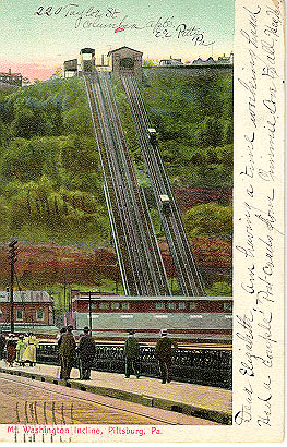
Pittsburgh's first incline, the Monongahela, opened on May 28, 1870. This was a full three years before San Francisco's first successful cable car line went into operation. Situated near the south end of the Smithfield Street bridge, the "Mon" incline enabled citizens to live and work in hilltop neighborhoods hundreds of feet above the Golden Triangle, with its crowded streets, sooty skies, and frequent floods.The popularity and success of the Mon led to an incline boom, with no less than fifteen separate installations (some sources say there were twenty) constructed around town between 1870 and 1901. (See table below.)
While most of the Pittsburgh inclines carried only passengers, some carried freight and other vehicles. Most notably, a separate freight incline was built adjacent to the original Mon, and the Castle Shannon incline's large cars were designed to carry road vehicles. Lucky are those whose childhood memories happily include taking the family car for a ride on the Castle Shannon. In Cincinnati, another city with hilly topography, there were also numerous inclines, although all have long since been abandoned. The inclines there carried not only passengers, freight, and road vehicles, but some accommodated horsecars, electric trams, and even motor buses!
The growth and expansion of electric streetcar service in Pittsburgh from the 1890s onwards gave stiff competition to some of the inclines: improvements in vehicle technology and tunnel construction soon allowed for electric trams to tackle the city's hills. Once trolleys had gone over the top--especially in the case of Mount Washington---a vast network of suburban and interurban routes began to develop. The inclines would continue to fill a niche, but they were no longer the best or primary means of commuting to and from hilltop communities and the Golden Triangle.
While some of the area's inclines were decidedly short-lived, the survival of the more successful specimens until the mid-20th century and beyond was a testiment to their true utility and durability. Indeed, the two surviving Pittsburgh inclines are also the two oldest, and incline buffs can only lament that inclines such as Mount Oliver, Knoxville, and Castle Shannon, which were still operating as late as the 1950s and '60s, might have made equally fine tourist attractions had they ultimately survived. Alas, these inclines were not nearly as well-situated geographically as the Mon and the Duquesne Inclines, whose guardian angels were able to point to those lines' enduring civic value as transit lines and tourist attractions, in addition to their historic significance.
A wide variety of Inclined plane railways once operated in North America, ranging from glorified "elevators" to massive freight- and vehicle-carrying machines such as those described above. As roads improved and more and powerful autos were built, inclines became as anachronistic as electric streetcars and other supposedly outmoded forms of public transportation. Of those that survive today, it may be said that while they still perform a useful function, most have earned their keep serving tourists as well as locals, as in Niagara Falls, Quebec City, Los Angeles, and of course, Pittsburgh.
| INCLINE | OPENED | CLOSED | LOCATION |
|---|---|---|---|
| Monongahela | 1870 | n/a | South side, nr. Smithfield St. Bridge |
| Mount Oliver | 1871 | 1951 | South side-Mt. Oliver, nr. later Knoxville Incline; upper stn. at S. 18th St. |
| Duquesne | 1877 | n/a | South Side-Mt. Washington, from W. Carson Street nr. Point Bridge to Grandview Ave. |
| Monongahela Freight | 1884 | 1935 | Adjacent to Mon Passenger incline |
| Penn (17th Street) | 1883 | 1953 | Penn Avenue & 17th Street, Pittsburgh. |
| St. Clair (22nd Street) | 1886 | 1935 | South Side, 22nd Street- Arlington Ave. area |
| Nunnery Hill | 1887 | 1899 | North Side-Fine View; stations at Federal & Henderson and Catoma & Lanark |
| Troy Hill | 1887 | ??? | North Side, base station probably on E. Ohio |
| Bellevue | 1887 | 1892 | Location? |
| Ridgewood | 1889 | 1900 | North Side, nr. Charles & Strauss |
| Knoxville | 1890 | 1960 | South Side--from E. Carson & 10th area, curving in a backwards 'L' shape up to Warrington Ave. |
| Castle Shannon | 1890 | 1964 | South Side--from Carson & Arlington to Bailey Avenue (terminus of former streetcar route 33) |
| Castle Shannon South | 1892 | 1914 | See Parkinson book p.29 for description |
| Clifton | 1895 | 1905 | Can anyone tell me the location of this one? |
| Norwood | 1901 | 1923 | McKees Rocks--Island Avenue to...? |
| Fort Pitt | c.1882 | ??? | Station nr. Second Avenue & 10th |
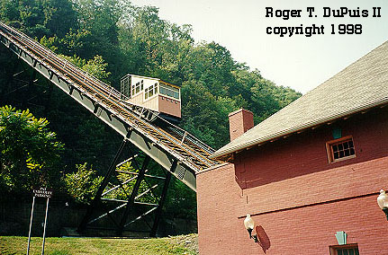
The success of the Mon incline in its first decade of operation was phenomenal, and the early 1880s saw two important developments. First, the original structure of the passenger line was upgraded from timber to steel. That was circa 1882. A year or so later, the adjacent Monongahela Freight Incline opened for business, allowing for haulage of goods up and down Mount Washington.
Five decades hence, the cumulative effects of competition from streetcars and motor vehicles had taken their toll. The Mon freight incline was closed in 1935, but through foresight or perversity the Monongahela Inclined Plane Company renovated the passenger incline at that time, replacing the line's steam engine with electrical equipment.
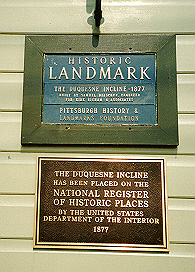
For the Mon, there would be a happy ending. Acquired by the Port Authority of Allegheny County in 1964, it became a part of PAT's region-wide transit operations, which then included the still-vast network of PCC-operated streetcar lines. The Mon has undergone two major renovation projects under PAT operation. In 1982-83, the line was shut down to allow for overhaul of its structure, station, and cars. In 1994, extensive rehabilitation/replacement of motor and braking systems took place, as well as improvements in wheelchair acessibility. The line remains a justifiably popular tourist attraction as well as a functional component of the local transit system, and is steps away from the Station Square shopping complex, the Station Square "T" (trolley) station, and local buses. It is recognized as a National Historic Landmark and as an historic structure by the Pittsburgh History and Landmarks Foundation.
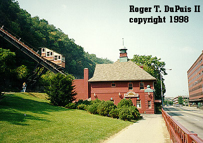
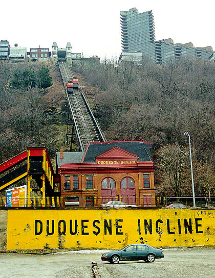
The Duquesne Incline was saved from oblivion largely due to the efforts of a group of concerned local citizens who formed the Society for the Preservation of the Duquesne Heights Incline. In 1963, this outfit raised the funds necessary for its retention and restoration, and still exists to oversee the line's operation as a non-profit enterprise.
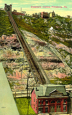
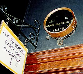
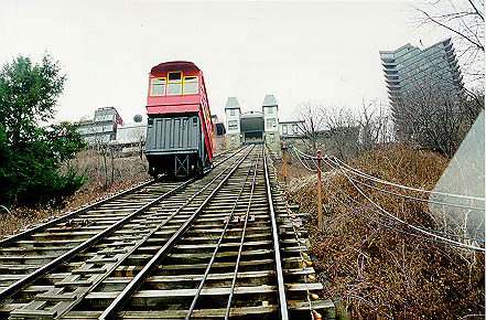
While admittedly somewhat removed from the main tourist attractions as compared to the ideal location of the Mon (in the heart of the Station Square shopping and historic area), the Duquesne Incline's claim to fame rests on its quaint Victorian cars and the spectacular vistas offered from its location. Unlike on the Mon, the cars riding the Duquesne's rails are bona fide originals, and their probable horsecar lineage is clearly evident. Ornate wooden panels, brass fittings, and amber glass windows in the deck roofs characterize the spacious cars, which have a gentle sway and rhythm all their own. The original steam engines were long ago replaced by electric motors, although Society literature indicates that the cable drum and wooden-toothed drive gear are all-original and have worked flawlessly since 1877. The polished brass starting bell located in the upper station certainly adds to the nostalgic atmosphere, as does the signage posted in and around the building.
 For tourists and transit buffs alike, the Duquesne's summit station is a must-see. In addition to the undiminished nostalgia of the building and waiting rooms, the station features many excellent historical displays, a well-stocked gift shop (with friendly attendants), and an outdoor observation deck. The base station is located in a non-descript and somewhat uninviting industrial neighborhood along West Carson Street--hardly a tourist's haven. The summit station, however, is located on the aptly named Grandview Avenue, with its breathtaking views of Downtown Pittsburgh. Unfortunately, the route 40 streetcars of old may no longer run by the front doors, but the neighborhood does boast of interesting architecture and some good restaurants in addition to the world-class view. Free parking is offered at the lower station, and PAT buses operate past both upper and lower stations. For those inclined to walk from the Mon Incline/Station Square area to the Duquesne Incline, the recommended route is along the TOP OF MOUNT WASHINGTON and GRANDVIEW AVENUE, both for aesthetic and safety reasons (as the busy Carson Street corridor is not pedestrian-friendly or residential, like Grandview). Although the distance is less than one mile, gently hilly topgraphy results in some uphill walking in both directions. Comfortable shoes and a healthy constitution are thus recommended!
| INCLINE | HEIGHT | LENGTH | ANGLE | CONTACT INFORMATION |
|---|---|---|---|---|
| Monongahela | 367.39 feet | 635 feet | 35 degrees, 30 minutes | (412) 442-2000 |
| Duquesne | 400 feet | 800 feet | 30 degrees | (412) 381-1665 Mailing Address: 1220 Grandview Avenue, Pittsburgh, PA 15211 |
Return to PITTSBURGH RAILWAYS OnLINE
Return to TRAMS STOP HERE
www.digits.com A great source for page counters
Visitors since March 31, 1999
LINKS