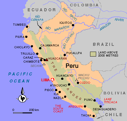
Peru:
Geography: Peru renowned as the land of the Incas, has an
area of 1,285,216 square kms, and it is on the Pacific Coast of
north-central South America.It is the third largest country in South
America, behind Brazil and Argentina. Peru is considered a tropical
country.
It has three major regions, a narrow coastal belt, the wide
Andean mountains, and the Amazon rainforest. The coastal strip is
mostly desert; however the major cities are found in that area
which are connected by the Pan-American highway. The rivers running
down the steep slopes of the Andes, generate narrow oases
(valleys) where most of the agriculture centres seat.
Distinctive and exotic plants and animals inhabit these three
different regions. From llamas, alpacas, vicunas and condors to
piranhas and toucans; Peru is a naturalist's paradise.
The Andes rise rapidly from the coastland. Just 100 km
inland the Andes reach 6000 meters (19,688 feet.) The Huascaran
is the highest mountain with 6768 meters (22,208 feet.)
Most of Peru's Andes lie between 3,000 and 4,000 meters,
separated by vertiginous canyons.
Driving in the mountain roads in
that area requires much expertise and a lot of guts, since minor roadways
are two way traffic, but only wide enough to accommodate one
vehicle. These roads have passing zones only at certain intervals, so
many times a vehicle has to back up for a good distance,
to let the other vehicle pass. The rule is that the vehicle
running uphill has the right of way, since it would be
very dangerous for the driver to backup the vehicle downhill,
and keep control of the vehicle because of the steepy
roadway grades.
Once crossing to the other side of the
Andes, the east slopes are mostly green because of rainfalls,
opposite with the west slopes which are dry. However
the east slope has very few roads. The best way to penetrate
the Amazon Basin is either by river or air.
Peru is the site of many great civilizations, that
makes the country so fascinating. From the ancient Inca capital,
Cuzco, the lost city of Machu Picchu, to the mysterious Nazca lines,
or the vast adobe ruins of Chan Chan, as well the opulents cities
founded by the Spanish conquerors. Undoubtly the scenery is the most spectacular you can find in South
America.
Archaeology and History: The famous Inca civilization is only
one part of the whole archaelogy. Before the Incas, Peru had the
pre-Columbian cultures, some preceding the Incas by many
centuries.
To give a detailed chronological order of these cultures would be
a difficulta task, since none of them had a written language. All
the information has been obtained from archaelogical excavations.
In addition one culture succeded another, bringing its own values,
as the Spanish did when they conquered the Inca Empire. The only
difference is that the Spaniards left written records.
Peru is unique in South America for its archaelogical wealth. Travellers
enjoy visiting centuries-old ruins. The ceramics and textiles that
these cultures left behind are one of the most important sources of
information about the pre-Columbian inhabitants. You can see these
relics in Peru's museums.
The Stone Age: The first inhabitants of Peru were nomadic hunters, and gatherers who
roamed the territory in bands. They lived in caves. Until almost
4000 BC, cultural development consisted only of stone implements
for hunting. They learned how to make fires, they wore animal skins,
and made simple tools and weapons mostly from stone and bones.
Early Agriculture:About 4000 BC, the inhabitants learned to plant seeds, improving
crops by means of weeding. They settled mostly in the coastal areas,
that were wetter than today. They cultivated cotton, chilli peppers,
beans, squashes and corn. They used the cotton for clothing, using
the techique of twining, and years later weaving. The people lived
in one-room stone-lined pit dwellings. Jewelry made of bones, shells
were used.
Early Formative Period: The early period from about 1250 BC to 850 BC, known from remains found in
the Viru Valley and Guanape Area south of Trujillo (located on the
north coast). In this period Ceramics were developed from rude
undecorated pots to sculptured coloured pots of high quality. Weaving,
fishing, and horticulture improved.
Chavin Culture: This period, from 850 BC to 300 BC, is named after
the site of Chavin de Huantar, east of Huaraz which is one of the most
ancient shrines in the Americas. It is termed a 'horizon'
due to its artistic and religious influences can be observed in other
contemporary cultures. The Chavin influenced an area covering most of the
northern Peru's highlands and coast. It is believed they worshipped the
jaguars, since this animal appears in many of their pottery. This period
represents the greatest early development in weaving, pottery,
agriculture.
 Late formative period: Around 300 BC the Chavin culture misteriously
dissapeared. Over the next 500 years other cultures were important. Some
of these are "The Salinar culture", located in the Chicama Valley, near
Trujillo, and "The Paracas Necropolis" south of Lima. The Salinar ceramics
show advanced firing techniques. The textiles of Paracas are considered the
finest pre-Columbian textiles in the Americas.
Late formative period: Around 300 BC the Chavin culture misteriously
dissapeared. Over the next 500 years other cultures were important. Some
of these are "The Salinar culture", located in the Chicama Valley, near
Trujillo, and "The Paracas Necropolis" south of Lima. The Salinar ceramics
show advanced firing techniques. The textiles of Paracas are considered the
finest pre-Columbian textiles in the Americas.
Regional Development: This period, from 100 AD to 700 AD, was
marked by independent develop in several areas. Pottery, metalwork and
weavings reached a high point of technology throughout Peru. This period
is called often the "Classic" and sometimes the "Florescent".
In this period two cultures were very important, the Moche that
was established in the city of Trujillo, and the Nazca
in the south coast. They recorded the ways of life on their
ceramics. The Moche culture also built massive pyramids.
Examples of these are the temples of the Sun and the Moon,
near Trujillo. The Moche left a stunning record. Preserved in ceramics,
weavings, and metalwork is an exquisite portrait of ritual,
daily life, and even unusual individuals, rivaling the art of the European Renaissance that came a
thousand years later. The Moche were embroilled in frequent
territorial wars. Eventually, scientifics believe, they
were absorved by the Wari, Peru's first agressively expansionist
state. The culture of Nazca made the petrogliphs
known as the Nazca Lines in the coastal desert.
The Wari Empire: Wari was the capital and the name of the
first empire known in the Andes. Unlike the Chavin culture, the Wari expansion
was not only limited to the diffusion of religion and
artistic influence. The Wari were military conquerors.
They built and maintained important outposts throughout
much of Peru. Some of these places were Piquillacta near
Cuzco, Cajamarquilla near Lima, and Wilkawain near Huaraz.
The Wari subdued the cultures they conquered, by
enforcing their own values. This happened from about 700
to 1100 AD. The wari influence was in the art, technology
and architecture of most areas in Peru. When they conquered
other cultures they forbade any existing tradition. When colonized
cities began to grow, or with the arrival of other
rivals, the Wari, at their peak, began to decline. Anyhow
the Wari were also overthrown at one time and their
culture also obliterated.
The Regional States:
Around 1100 AD the Wari had been
overthrown by other groups in their areas. During 300 to 400
years these separate regional states thrived. One of the best
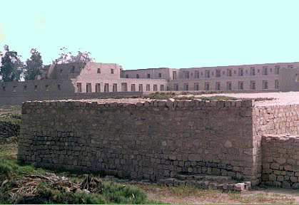
known in that area was the Chimu Kingdom that was located where
the city of Trujillo whose capital was the huge adobe city known
as Chan Chan, which is believed to be largest adobe city in the world.
Almost contemporary with the Chimu state was the Chachapoyas culture,
located by the Utcubamba River in the Department of Amazonas.
The Chancay people just north of the capital of Peru, Lima was also
contemporary of the Chimu. Between Lima and Ica was the Ica-Chincha
culture. It seems that there were also some tribes living near the
altiplano of the Lake Titicaca. They left some funerary towers. They can
be seen at Sillustani. Another culture were the Chankas who lived in
the Aprurimac/Ayacucho area. Also existed the Kingdom of Cuzco, the
predecessors of the Inca Empire.
The Inca Empire: Despite all its greatness the Inca Empire
barely existed over a century. Prior to 1430 the Incas ruled over
only the valley of Cuzco. They had been at war with the Chankas for
some time, but finally defeated the Chankas in a major victory
in 1430. This was the beginning of a great military expansion. The
Inca Empire conquered and incorporated most of the cultures in the
area stretching from southern Colombia to Central Chile. The Incas
imposed their way of life on the peoples they conquered. By the
time the Spanish arrived most of the Andean area had been thorougbly
homogenized by the Inca.
The Spanish Conquest: In November 1526, Francisco Pizarro headed south from Panama.
By 1528 Pizarro has explored as far as the Santa River in Peru.
He learned about the richness of the Inca Empire and returned
to Spain to raise money and recruit men for the conquest. On
1530 he landed on the Ecuadorean coast and began his march
towards overland. On 1532 he founded the first Spanish
town in Peru which he called San Miguel de Piura. On
November 1532 he reached Cajamarca, where The Inca Atahualpa
was residing at that time, after a civil war with his brother Huascar
whom he defeated and killed. With few men Pizarro captured
Atahualpa, taking advantage of the armor suits and the
horses that were unknown in America. After Atahualpa was
captured Pizarro asked for a ranson on pieces of gold.
With the excuse that Atahualpa failed to gather the ranson
and fearing a revolt, Pizarro executed the Inca Atahualpa.
Government: Peru is currently a democratic country, but this
has not been all the time. Like many other South American countries
from time to time, it has dictatorships, even sometimes are disguised
behind the democracy mask.
Anyhow Peru got its independence from Spain on July 28, 1821 when
The Libertador General Jose San Martin proclaimed the independence
from a balcony in the City of
Huaura
Capital: Lima. Founded January 18, 1535. Located south of the equator.