Abandoned & Little-Known Airfields:
Southeastern Arkansas
© 2002, © 2016 by Paul Freeman. Revised 11/19/16.
This site covers airfields in all 50 states: Click here for the site's main menu.
____________________________________________________
Please consider a financial contribution to support the continued growth & operation of this site.
Erwin Aux AAF (revised 11/19/16) - Milltown Aux AAF (revised 12/7/13) - Worth James Airport (revised 8/23/16)
____________________________________________________
Worth James Airport, Little Rock, AR
34.707, -92.328 (Northwest of Memphis, TN)
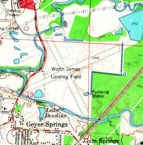
“Worth James Landing Field”, as depicted on the 1961 USGS topo map.
Photo of the airport while in use has not been located.
This small airfield was located on the west side of Little Rock.
Worth James Airport was evidently established at some point between 1957-60,
as it was not yet depicted on the 1957 USGS topo map.
The earliest depiction which has been located of Worth James Airport was on a 1960 aerial photo.
It depicted the airport as having 2 perpendicular unpaved runways, with 2 hangars on the west side.
There were no aircraft visible on the field.
The 1961 USGS topo map depicted “Worth James Landing Field” as having 2 perpendicular unpaved runways,
with 2 hangars on the west side.
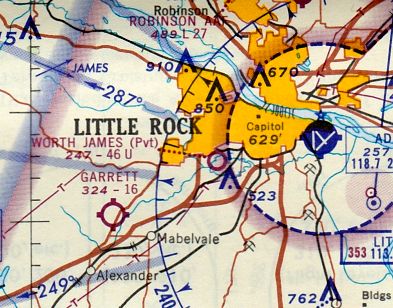
The only aeronautical chart depiction which has been located of Worth James Airport
was on the January 1966 Little Rock Sectional Chart (courtesy of Ron Kunse).
It depicted Worth James as a private airfield having a 4,600' unpaved runway.
There were no aircraft visible on the field.
A 1970 aerial photo depicted Worth Jamnes Airport in the same fashion as the 1960 aerial view.
The last labeled map depiction which has been located of Worth James Airport was on the 1986 USGS topo map,
which depicted it in the same fashion as the 1961 USGS topo map.

Worth James Airport was evidently closed at some point between 1986-94,
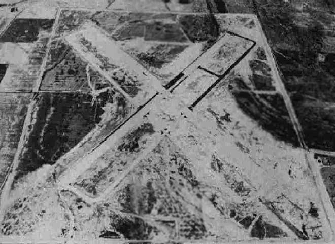
as 1994 USGS aerial view looking north showed the western portion of the airport's former 2 grass runways were still intact, along with 2 hangars to the northwest of the runway intersection.
But the eastern portion of the airfield had been removed.

A 2014 aerial view looking north showed the site of Worth James Airport had been covered with a surface mining operation,
with no trace remaining of the little airport.
The site of Worth James Landing Field is located southeast of the intersection of Mabelvale Pike & Asher Avenue.
Thanks to M.L. Anthony for pointing out this airfield.
____________________________________________________
Erwin Auxiliary Army Airfield / Erwin MCAF Auxiliary, Newport, AR
35.572, -91.255 (Northwest of Memphis, TN)

A 4/14/43 aerial view looking north at the “Newport MCAF Auxiliary (Erwin Field)”
from the 1945 AAF Airfield Directory (courtesy of Scott Murdock).
This airfield was one of 2 satellite fields
which were constructed during WW2 for the use of Newport Army Airfield (several miles northeast),
which conducted training as part of the 70,000 Pilot Training Program.
The date of construction of Erwin is unknown.
It was apparently built at some point between 1937-43,
as it was not listed among active airfields in The Airport Directory Company's
1937 Airports Directory (courtesy of Bob Rambo).
The earliest depiction of the Erwin airfield which has been located
was a 4/14/43 aerial view looking north from the 1945 AAF Airfield Directory (courtesy of Scott Murdock).
It depicted “Newport MCAF Auxiliary (Erwin Field)”
as having 2 paved runways with parallel taxiways.
The 1944 US Army/Navy Directory of Airfields (courtesy of Ken Mercer)
described Erwin as having a 4,500' hard-surfaced runway,
and the remarks said, "Aux to Newport AAF."
Newport AAF was closed by the Army in 1944 & turned over to the Marine Corps,
which operated SBD, SB2C, and PBJ squadrons from the field.
The 1945 AAF Airfield Directory (courtesy of Scott Murdock) described “Newport MCAF Auxiliary (Erwin Field)”
as a 501 acre rectangular property having 2 asphalt 4,500' runways, oriented northeast/southwest & northwest/southeast.
The field was not said to have any runways,
to be owned by the U.S. Government, and operated by the Marine Corps.
The earliest aeronautical chart depiction of the Erwin airfield which has been located
was on the October 1945 Little Rock Sectional Chart (courtesy of Chris Kennedy).
“Erwin” was still depicted as an auxiliary airfield on the September 1946 Little Rock Sectional Chart (courtesy of Chris Kennedy).
"Erwin AF" was depicted on the January 1949 Little Rock Sectional Chart (courtesy of Chris Kennedy).
The February 1956 Little Rock Sectional Chart (courtesy of Chris Kennedy)
depicted "Erwin AF" as having a 4,500 unpaved runway.
The Erwin airfield was apparently abandoned at some point after 1956.
Claud Pipkin recalled, “My Grandfather, from the early 1950s to the mid 1960s was a Dodge-Plymouth dealer in Newport.
I think he bought the Erwin Auxiliary airfield & farmed it... perhaps I should say he tried to farm it.
The land around it grew crops OK but the old airstrip just seem to defy all efforts.
To my knowledge he never mentioned that the airstrip was ever paved.
Of course it had been heavily tamped (with sheep-foot rollers I'm sure).
My Dad & I went to see it once with Granddad.
Being a airplane nut, even at that age, I had to know all about it.
He stated that it was a practice landing field for the B-25 pilot trainees from the main training field at Newport.”

The 1962 USGS topo map depicted the Erwin field as “Airport (Abandoned)”,
and depicted it as having 2 runways, each with a parallel taxiway.
Four small buildings were depicted on the runways at the center of the field.
The Erwin airfield was was labeled "Abandoned airport"
on the July 1964 Little Rock Sectional Chart (courtesy of Chris Kennedy).

The 1981 USGS topo map depicted the Erwin field as “Airport (Abandoned)”,
and depicted it as having 2 runways, each with a parallel taxiway.
Six small buildings were depicted on the runways at the center of the field.

A 1994 USGS aerial view looking west depicted Erwin Auxiliary Airfield as having two 5,000' runways, each of which has a parallel taxiway.
The remains of the runways & taxiways were still plainly evident, though somewhat deteriorated.
Several buildings (for agricultural use?) had been placed over the former runways since the field's closure.

A 2014 aerial view looking west showed 2 runways remaining recognizable at the site of the Erwin airfield.
____________________________________________________
Milltown Auxiliary Army Airfield / Milltown MCAF Auxiliary, Tuckerman, AR
35.73 North / 91.11 West (Northwest of Memphis, TN)
A 4/14/43 aerial view looking north at the “Newport MCAF Auxiliary (Milltown Field)”
from the 1945 AAF Airfield Directory (courtesy of Scott Murdock).
This airfield was one of 2 satellite fields
which were constructed during WW2 for the use of Newport Army Airfield (located a few miles to the southwest),
which conducted training as part of the 70,000 Pilot Training Program.
The date of construction of Milltown is unknown.
It was apparently built at some point between 1937-43,
as it was not listed among active airfields in The Airport Directory Company's
1937 Airports Directory (courtesy of Bob Rambo).
The earliest depiction of the Milltown airfield which has been located
was a 4/14/43 aerial view looking north from the 1945 AAF Airfield Directory (courtesy of Scott Murdock).
It depicted “Newport MCAF Auxiliary (Milltown Field)”
as having 2 paved runways with parallel taxiways.
The April 1944 US Army/Navy Directory of Airfields (courtesy of Ken Mercer)
described the Milltown field as having a 4,500' hard-surfaced runway,
and the remarks said, "Aux to Newport AAF."
Newport was closed by the Army in 1944 & turned over to the Marine Corps,
which operated SBD, SB2C, and PBJ squadrons from the field.
Milltown was also reused by the Marines, to conduct Field Carrier Landing Practice.
The 1945 AAF Airfield Directory (courtesy of Scott Murdock) described “Newport MCAF Auxiliary (Milltown Field)”
as a 480 acre rectangular property having 2 asphalt 4,500' runways, oriented northeast/southwest & northwest/southeast.
The field was not said to have any runways,
to be owned by the U.S. Government, and operated by the Marine Corps.
The date of Milltowns's closure by the military is unknown,
but it was most likely abandoned immediately after the end of WW2,
as was the case with many satellite airfields.
The earliest aeronautical chart depiction of the Milltown airfield which has been located
was on the October 1945 Little Rock Sectional Chart (courtesy of Chris Kennedy).

The last aeronautical chart depiction of the Milltown airfield which has been located
was on the September 1946 Little Rock Sectional Chart (courtesy of Chris Kennedy).
Milltown's parent military airfield, MCAAF Newport, was deeded to the city of Newport in 1947.
The Milltown airfield was evidently abandoned at some point between 1946-49,
as it was no longer depicted at all on the January 1949 Little Rock Sectional Chart (courtesy of Chris Kennedy)
or subsequent Sectional Charts.

A 1/25/64 USGS aerial photo showed the configuration of the Milltown runways to remain recognizable but deteriorated.

A portion of the Milltown airfield may have seen some later reuse as a civilian airfield,
as a 2,000' portion of the southwest end of the northeast/southwest runway
was labeled "Oil Trough Landing Strip" on the 1980 USGS topo map.
The northeastern end of the runway was labeled as the "Parsley Reservoir".
Milltown was not listed among active airfields in the 1982 AOPA Airport Directory (courtesy of Ed Drury).

As seen in the 1994 USGS aerial photo,
the Milltown airfield consisted of two 5,000' runways, each of which had a parallel taxiway.
This is exactly the same runway configuration as Erwin Aux AAF,
another one of the former Newport auxiliary airfields.
The remains of the runways & taxiways were still plainly evident, though somewhat deteriorated.
The southwest end of the northeast/southwest runway
was apparently reused for civil aviation, as it is in noticeably better condition than the remainder of the original runway.
The northeast end of that runway (labeled on the 1980 topo map as the "Parsley Reservoir")
did not appear to be a reservoir in the 1994 aerial photo.
The airfield at Milltown was no longer depicted at all (even as an abandoned airfield) on 2002 aeronautical charts.

A 1/11/06 aerial view looking northeast showed 2 runways remaining recognizable at the site of the Milltown airfield.
The site of Milltown Aux AAF is located north of Route 73, five miles east of Tuckerman.
Thanks to Joe Benson for pointing out this airfield.
____________________________________________________
Since this site was first put on the web in 1999, its popularity has grown tremendously.
That has caused it to often exceed bandwidth limitations
set by the company which I pay to host it on the web.
If the total quantity of material on this site is to continue to grow,
it will require ever-increasing funding to pay its expenses.
Therefore, I request financial contributions from site visitors,
to help defray the increasing costs of the site
and ensure that it continues to be available & to grow.
What would you pay for a good aviation magazine, or a good aviation book?
Please consider a donation of an equivalent amount, at the least.
This site is not supported by commercial advertising –
it is purely supported by donations.
If you enjoy the site, and would like to make a financial contribution,
you
may use a credit card via
![]() ,
using one of 2 methods:
,
using one of 2 methods:
To make a one-time donation of an amount of your choice:
Or you can sign up for a $10 monthly subscription to help support the site on an ongoing basis:
Or if you prefer to contact me directly concerning a contribution (for a mailing address to send a check),
please contact me at: paulandterryfreeman@gmail.com
If you enjoy this web site, please support it with a financial contribution.
This site covers airfields in all 50 states.