
Abandoned & Little-Known Airfields:
Western Connecticut
© 2002, © 2016 by Paul Freeman. Revised 8/14/16.
This site covers airfields in all 50 states: Click here for the site's main menu.
____________________________________________________
Please consider a financial contribution to support the continued growth & operation of this site.
Ansonia Airport (revised 8/14/16 - Bethany Airport (revised 6/14/16) - Jonnycake Airport / Mountain Meadow Airport (revised 9/1/14)
Monroe Airport (revised 8/17/15) - Norwalk Airport (revised 8/14/16)
____________________________________________________
41.14, -73.42 (Northeast of New York, NY)
Norwalk Airport was depicted on the 1931 Air Navigation Map as an unlabeled auxiliary airfield (the read cross on the north side of Norwalk).
This small general aviation airport was evidently established at some point between 1929-31,
as it was not yet depicted on a 1929 aerial photo (courtesy of Thomas Cossuto).
According to Thomas Cossuto, “The Norwalk Airport was built for Dr. Alvin Wadsworth’s son because he was into aviation.”
According to Ray Jacobelli, “The Fodor's operated a machine shop during the 1920s.
I met a relative several months ago who told me one of the Fodor's was interested in starting an aircraft manufacturing business.
The son bought the Mutual Aircraft Company (Kansas City, MO) and the rights to manufacture the Mutual Blackbird biplane,
which was designed by Giuseppe Bellanca & one of the first to be constructed used a welded steel tube fuselage
The flight of the Blackbird to Norwalk occurred prior to the stock market crash of 1929.
Fodor flew the airplane back east, landing at Norwalk Airport, but ground looped & damaged the airplane.
The airplane was disassembled & trucked back to their farm.”
The earliest photo which has been located of Norwalk Airport was on the 1931 Air Navigation Map,
which depicted an unlabeled auxiliary airfield on the north side of the town of Norwalk.
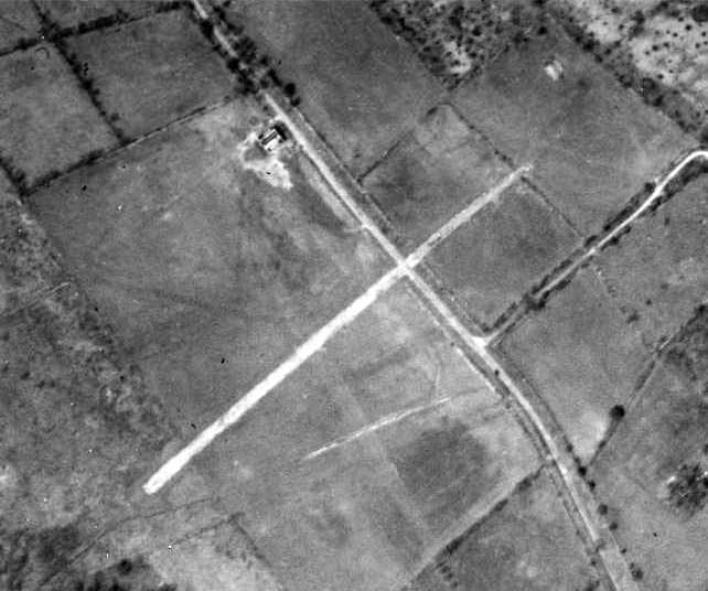
The earliest dated photo which has been located of Norwalk Airport was a 1934 aerial view.
It depicted Norwalk as having a single hangar on the north side of a grass airfield.
A northeast/southwest runway appeared to cross Rocks Road.
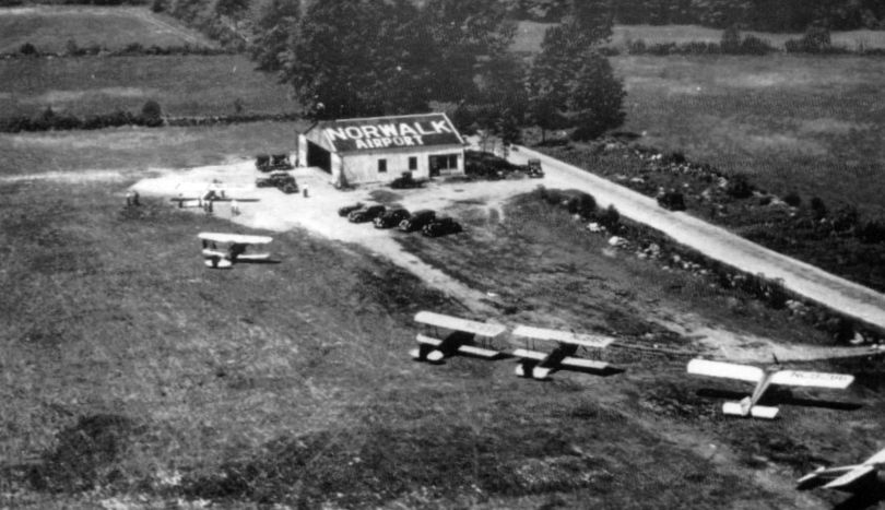
The only photo which has been located showing Norwalk Airport in use
was a circa 1930s aerial view which depicted 6 single-engine aircraft next to a hangar labeled “Norwalk Airport”.

The last aeronautical chart depiction which has been located of Norwalk Airport was on the 1938 NY Sectional Chart,
which depicted Norwalk as a commercial/municipal airport.
According to Ira Perelle, Norwalk Airport “was used as an aircraft spotter's post early in the WW II years (to watch for the arrival of enemy aircraft).
I was in high school in those years, and volunteered as an aircraft spotter, which is how I learned of its existence.
There wasn't much on the field, just a grass strip & a few shacks, although old-timers told me that it had been active during the 1930s.”

The last depiction which has been located of Norwalk Airport was on the 1943 USGS topo map,
which depicted Norwalk Airport as an open area with a few small buildings along the periphery.
The Norwalk Airport was evidently closed (for reasons unknown) at some point between 1943-45,
as it was no longer depicted on the 1945 NY Sectional Chart.
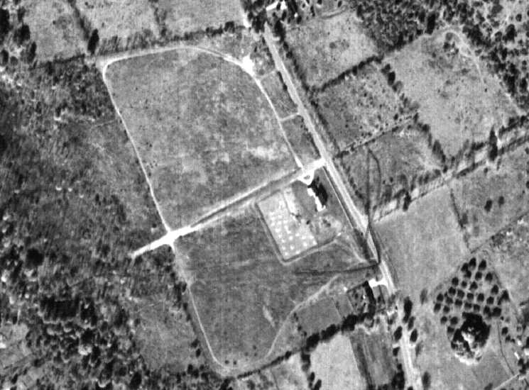
A 1951 aerial photo showed the remains of the Norwalk runway.
Kevin Daly observed, “The runway no longer crossed the road to the east but was extended through a farm's stonewall to the west.
The original building is gone & a new hangar is right next to the runway to its south.”
A 1960 aerial photo showed that the All Saints Catholic School had been built over the site of Norwalk Airport at some point between 1951-60.
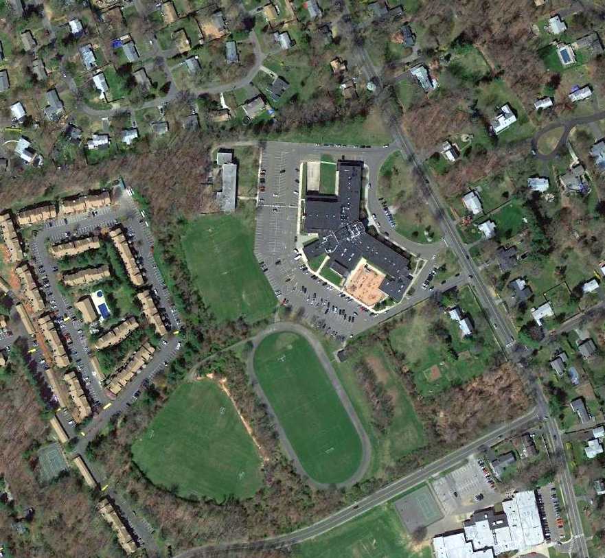
A 3/9/12 aerial view shows All Saints Catholic School covering the site of Norwalk Airport.
The site of Norwalk Airport is located northwest of the intersection of Aiken Street & West Rocks Road.
____________________________________________________
41.34, -73.05 (Southwest of Hartford, CT)
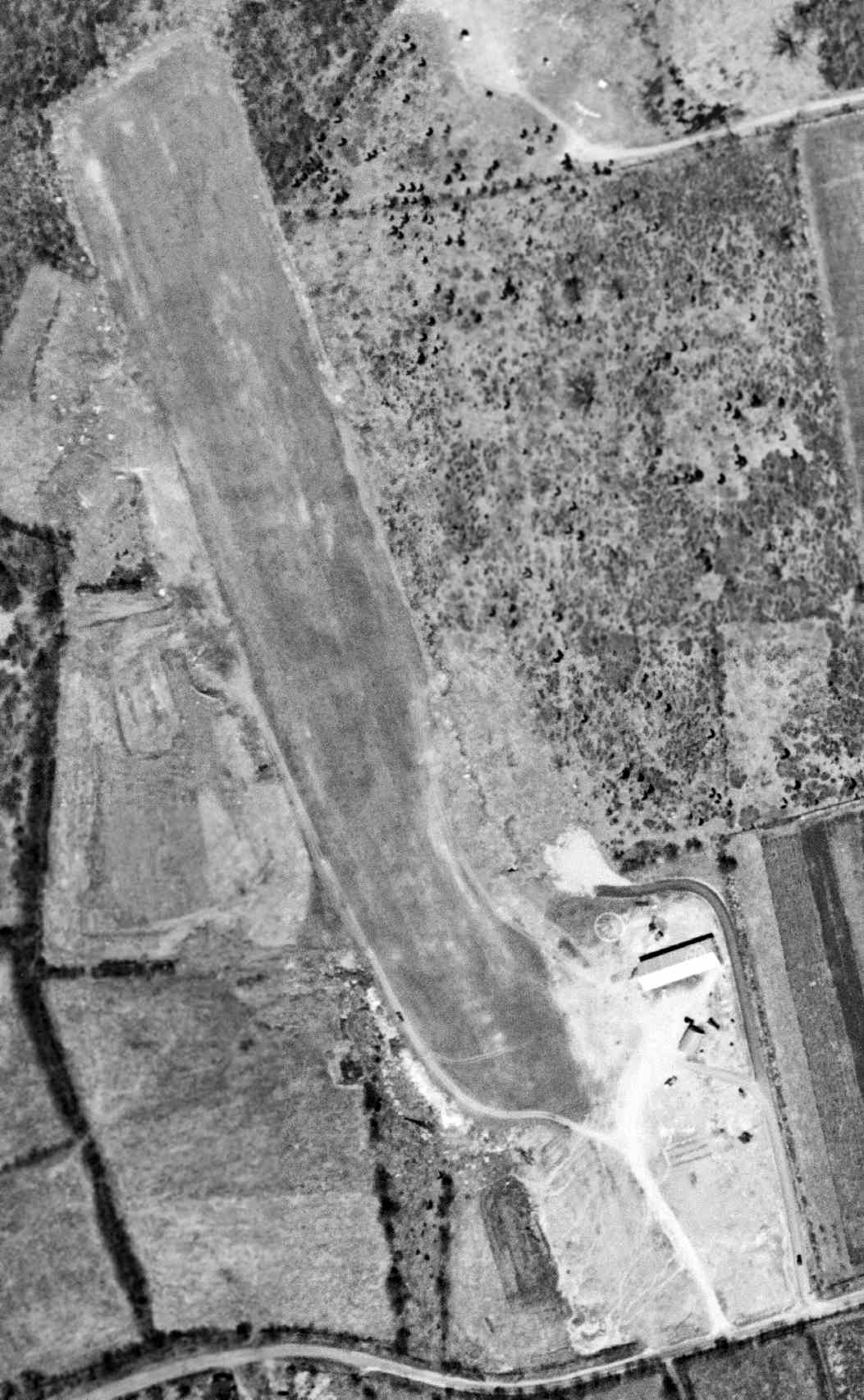
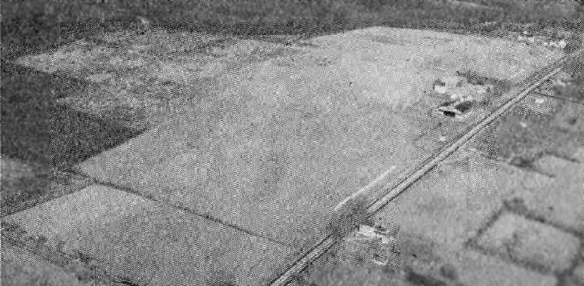
Ansonia Airport, as depicted on a 4/21/49 USGS aerial photo.
A 1934 aerial photo did not yet depict an airfield at this location,
and Ansonia was not yet listed among active airfields in the 1945 AAF Airfield Directory (courtesy of Scott Murdock).
The earliest photo which has been located of Ansonia Airport was a 4/21/49 USGS aerial view.
It depicted a grass northwest/southeast runway, with a single hangar & some smaller buildings at the southeast side.

The earliest aeronautical chart depiction which has been located of Ansonia Airport was on the 1950 NY Sectional Chart,
which depicted Ansonia as having an 1,800' unpaved runway.

The 1953 USGS topo map depicted “Ansonia Airfield” as having a northwest/southeast unpaved runway with 3 small buildings on the southeast side.
On 7/8/55 the Army announced that they would be acquiring several parcels of land for a Nike Ajax missile installation in Ansonia.

An undated aerial view looking northeast at Ansonia Airport from the 1956 CT Airport Directory (courtesy of Stephen Mahaley).
The directory described Ansonia as having an 1,800' sod north/south runway, and 3 hangars were depicted at the southeast side.
The operator was listed as Ansonia Airport Inc., and the manager as Chester Zebrowski.
Nike battery BR-04 was activated in 1957 as part of the Nike system's Bridgeport Defense Area,
equipped with the 1st-generation Nike Ajax missile.
The Nike Integrated Fire Control Site was located adjacent to the east side of Ansonia Airport,
and the Launch Site was located less than a mile to the north.
Quite the odd juxtaposition – a grass airport operating light planes,
right next to a military installation housing radar-guided supersonic surface-to-air missiles.
According to Robert McGuire, “Stories from some of the old timers said that they used to bring in DC-3 (the military version) to bring in supplies for the missiles.”
In the mid-1960s, Ansonia Nike Site BR-04 was the only Nike battery in the Bridgeport Defense Area to be upgraded to the 2nd-generation Nike Hercules missile.
The residents of the small town probably had no idea that some of the Nike Hercules missiles were equipped with a nuclear warhead.
A 1963 aerial photo showed that Ansonia had gained a 2nd hangar at some point between 1949-63.
A single light plane was visible near the hangars.

The last aeronautical chart depiction which has been located of Ansonia Airport was on the 1965 NY Sectional Chart,
which depicted Ansonia as having a 1,700' unpaved runway.
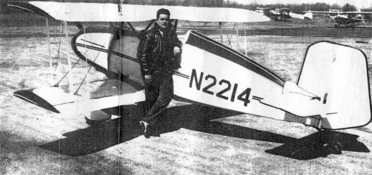
A 1960s photo of Karl Benner in front of his Jungster 1 at Ansonia Airport.
Von Moody recalled that he “Solo'd [at Ansonia Airport in January 1966.
Fairchilds, Stearmans, PT-22 & 23, F8F Bearcat, Waco's, Stinson, Cubs, Aeroncas and many other classics were based there, lots of history.
One of my instructors was an Me-109 Pilot. There was also the 4-place version of the Me-109 designated the Me-108 with a Lycoming 720 conversion in it.”
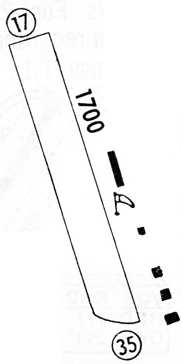
The 1968 Flight Guide (courtesy of Bob Levittan) depicted Ansonia Airport as having a 1,700' unpaved Runway 17/35 with 5 small buildings on the southeast side.
Fred Ouweleen recalled, “I discovered Ansonia Airport when I moved nearby in January of 1969. I was 16 & decided to learn how to fly.
My father decided to pursue this as well & he purchased a 1946 Piper J-3 N88211 for $2,300 which we based at Ansonia.
My instructor was Stanley. We would fly together without headsets making communication difficult if not nearly impossible.
Funny how it didn’t occur to the majority of the pilot population at the time to wear headsets.
He was said to have been a Luftwaffe pilot but my guess is that this was a story that was attributed to him & which he didn’t deny.
He was patient & friendly & taught me & my father to fly our Cub.
On one occasion he & I took off behind a brown Super Cruiser flown by the airport owner/manager whose first name was Ted.
We engaged in a mock dogfight low over the changing autumn leaves. I will never forget that experience.”
Fred continued, “I would play hookie from high school & head to the airport to clean or fly the Cub.
On one of these occasions, a Bearcat owned by a TWA pilot from Danbury circled the field to land.
I watched as he drifted halfway down the short field before touching down.
I figured he would try to go around but he stuck it on & then proceeded off the runway towards the hangars on the southeast side of the strip.
I was sure he was going to flip over & explode but he managed to bring it to a halt after a slow ground loop.
He never got out of the plane to inspect for damage but stayed in the cockpit with those big 4 blades continuing to turn.
Ted came out & pulled out a branch that was stuck in the landing gear well & he then took off in the other direction.
I later retraced the tire tracks of his sojourn off the runway & he missed rocks & potholes by inches.
The hangars contained some beautiful airplanes. I recall an ME-108, a Staggerwing and a WACO biplane.
Ted also rented J-3s & he would equip them with skis in the winter.”

A Summer 1969 photo by Ed Cox of Ansonia, showing “N108U, a Nord 1002 (I always thought that this was an Me-108 but apparently was a French-built variant).”

A Summer 1969 photo by Ed Cox of Ansonia, showing “the hangar which included the office. The Nord is visible close to the hangar.
This hangar had a serious hangar fire in which all aircraft, including the Nord, were lost.
The FBO in 1969 was Valley Air Service. This was owned by two pilots: Ted, Bob Sayles, and a mechanic whose name escapes me.”
Ed Cox recalled, “I took some of my early lessons at Ansonia.
They had two J-3s (N2086M & N35515) and a Cessna 150 (N3274J).
I also had an opportunity to fly 5-6 times with Stan.
He was from Eastern Europe (Lithuania?) and told me he had been impressed into the Luftwaffe where he had flown Stukas.
Back in the late 1960s there were a number of classic aircraft in the hangars or that dropped in to visit.
A number of these were the first or only examples I have seen.
These included a Mooney Mite, a Waco Model A, a Spartan Executive and a Stearman that never saw military service.”

A 1969-70 photo (courtesy of Fred Ouweleen) of Fred Ouweleen with his Piper Cub at a snowy Ansonia Airport.
Fred Ouweleen recalled, “In the summer of 1970, our family moved away.
I flew the J-3 out of Ansonia for the last time on a long cross country to St. Louis.
We sold the J-3 & bought a Cessna 170. In the summer of 1971 or 72 I flew it from St. Louis to CT.
I intended to fly it out of Ansonia with a friend to Long Island to go camping.
We had full fuel and halfway down the runway I could see we just might fly into the trees on the north end.
So fortunately I aborted the takeoff, off loaded fuel & asked my friend to meet me at Tweed New Haven.
That runway was short & with the obstacles on the north end, it was really only suitable for Aeroncas, Cubs and Luscombes…
not for heavily loaded Cessnas or Bearcats.”
Fred continued, “I have many warm memories of Ansonia & the adventures I had there.
For someone of my age at the time & new to town, it was a place to commune with flying & our beautiful J-3
and become connected with an eclectic group of people.
I am grateful to my parents who supported my flying & made this experience possible.
And yes, they knew about my playing hookie!”
According to Jerry O'Neil, Cliff Robertson's “old Me-108 was destroyed in a hangar fire at Ansonia Airport.”
John Boyce recalled, “I made a few flights out of Ansonia.
Teddy Tsovaris rented me a Cub that was probably not airworthy, lacking some required instruments. But cheap. I think it was $8/hour.
The maintenance operation was run by a former EAL flight engineer, Bill Neukom.
I flew my Fairchild 24 in there for an annual, but it never got done.
I couldn't get hangar space & it deteriorated badly, so I took it apart, improvised some sort of trailer hitch-up & towed it home.
The F8F was flown by TWA Captain Ron Reynolds.
There were some beautiful aircraft lost in that fire.
A Waco & Stearman, among others.”
Melillo recalled, “I flew out of the Ansonia Airport when I first got my private [pilot's licence] in 1971.”
Ansonia's Nike Battery BR-04 was decommissioned in June, 1971.
A 1972 aerial photo appeared to show Ansonia Airport at its zenith of popularity,
with a total of 8 light planes visible on the field.
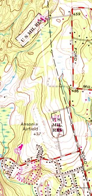
The last map depiction which has been located which still labeled Ansonia Airport was on the 1972 USGS topo map.
It it also depicted the 2 adjacent Nike missile installations (the Integrated Fire Control site to the east, and the Launch Site to the north), each labeled as “U.S. Mil. Res.”
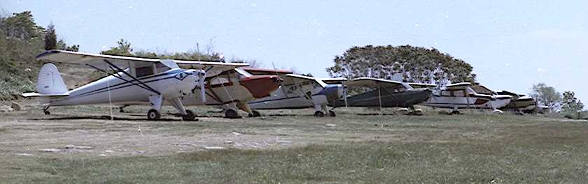
A 1973 photo by Bob Biancur of a row of 8 single-engine planes at Ansonia Airport.
John Boyce observed, “The pictures showed a good-looking PA-12 that had been well equipped to serve Neukom as an instrument trainer.”
Bob Biancur reported that upon finding his photos of Ansonia Airport, “They bring back pleasant memories of a really special place,
though calling that grass patch an airport is a bit of a stretch.
Ansonia Airport consisted of a 1,750' grass runway, a cobbled-together wood-burning stove for heating the Quonset hut,
a few leaky-roofed hangars, and a faded windsock that looked like a relic from barnstorming days.
It wasn’t much, but it was the next-best thing to heaven for a bunch of aviators who could only afford to fly on a shoestring budget.
Our planes were an odd assortment of vintage aircraft with such names as: Aeronca, Taylorcraft,
Luscombe, Bellanca, Aircoupe, Stinson, and of course the venerable Piper and Cessna.
The few amenities we had were not without quirks. For example, we had to avoid congregating in certain areas of the hut to avoid weak spots in the floor.
In summer the antique refrigerator chilled our beverages, but in winter it served an even more important purpose
by preventing contents from freezing when the hut was unattended.”
Bob continued, “One unique aspect of the flying club, perhaps taken for granted, were the veteran pilots who were always ready to lend a hand.
Without that special camaraderie the airport would never have lasted as long as it did.
Most memorable was Stan Cekanouskas, our flight instructor.
He could hold us spellbound with exciting exploits of Stuka dive bombing during WWII.
John Uhock, airport manager & keeper of the books. Chet Zembrowski, principal owner of the field.
Pete Peterson, the the go to person for technical advice. Leon Redmond, our chief mechanic, kept ‘em patched & flyin’.
Coonie Hewitt, a former Army Air Corps flight instructor, always ready to help a novice flyer 'straighten out & fly right'.
Walter Schlagel, sold me my first plane, and Joe Sliby, a fellow aviator who scoffed at the notion that something couldn’t be done.
These are but a few of the old-timers who shared their time and talent, and honed our skills.”

A 1975 aerial view by Bob Biancur looking east at Ansonia Airport from his Cessna 120.
Bob recalled, “I spent quite a bit of time there & met some fine pilots. It was my all-time favorite place.”
The Nike Integrated Fire Control Site was visible right behind the airport.

A 1978 photo of Bob Biancur at Ansona Airport “posing with my 1946 rag-wing Luscombe 8A.”
Matt Valleau recalled, “I moved to Connecticut in 1988, and the airport was in it's final throws then.
It closed shortly after I moved here (1988-89).”

The last photo which has been located showing Ansonia Airport still intact was the 4/3/91 USGS aerial view.
The runway & hangars were still intact, but there did not appear to be any recent aviation usage.
The adjacent Nike Integrated Fire Control Site to the east also remained largely intact.
Robert McGuire recalled, “We tried to buy the airport several time from the last of 3 original owners
but he sold out to a developer & he died a short time after. Now there are houses there.”
A 2004 aerial photo showed that houses were built over the site of Ansonia Airport at some point between 1991-2004.
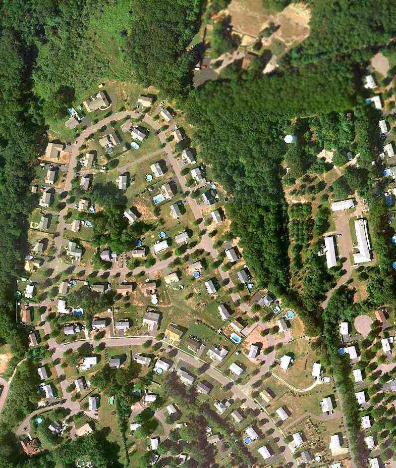
A 9/11/10 aerial view depicted houses covering most of the site of Ansonia Airport,
with only a clearing remaining at the site of the north end of the runway.
Bob Biancur reported in 2012, “Ansonia Airport is gone now, along with her sister airports Bethany & Monroe;
all having succumbed to the pressure of land developers, excessive regulation, exorbitant costs & lack of affordable planes.
The old flyers are gone too; though when I hear the fading drone of a little airplane climbing for the clouds,
or the chance passing of a biplane with its unmistakable throaty radial engine, I’m reminded of Ansonia’s halcyon days.
It was a hoot while it lasted.
I drove out to see if I could recognize anything of the airport.
Nope. Just another housing development. Kinda brought a tear to my eye.”
The site of Ansonia Airport is located northwest of the intersection of Ford Street & Sobin Drive.
____________________________________________________
41.32 North / 73.2 West (Southwest of Hartford, CT)

A circa 1946 photo (courtesy of Faith Johnson) of her father (Norman Krysta) & his sister (Catherine Krysta Edwards) in front of a Taylorcraft at Monroe Airport.
Kevin Daly recalled, “I grew up on Pamela Drive at the south end of Wheeler just beyond Cross Hill Road.
You could say that my location and a boyhood fascination with the Monroe Airport sort of define who I am even today.
Lois Hurd's grandfather, Ambrose Hurd owned & farmed the land where the airport would eventually be built.
The fields were once divided by stone walls from Moose Hill Road east to Wheeler Road & were filled with grazing dairy cows.
Ambrose died in 1929 from injuries he sustained from being kicked by a farm animal - either a horse or cow.
After Ambrose died his son Ben immediately sold off all the dairy cows.
He had absolutely no interest in farming whatsoever & had more contemporary ideas in mind.”
Kevin continued, “In the early 1930s there was a car race track practically at the intersection of what we know as Four Corners in Shelton.
This was a very successful venture during the early Depression years & Ben saw an opportunity to open a larger track in Monroe on the former farmland.
So what you know as the The Monroe Airport was once a thriving racetrack. Cars reached speeds of nearly 100 MPH.
And you thought Monroe was a quiet farming town. Not in 1934 it wasn't.
There were practically no trees across the entire town & the roar of finely tuned engines could be heard for miles.”
A 1934 aerial photo showed an oval racetrack on the property.
According to a local resident, “The track lasted for a few years & during this time Ben was taking flying lesson at Bridgeport Airport. He'd caught the flying bug.
The original airstrip was across the street, north of the Hurd's house (the large white house on Moose Hill across from the airport)
and ran all the way north to where the Monroe Firehouse is today - basically Hurd Avenue.
In the late 1930s tensions of war in Europe gave Ben another idea.
He would build an airport & teach pilots to fly should America become involved in the war.
One of Ben's jobs at this time was building roads & he had earthmoving equipment at his disposal.
So at night, he & his young daughter Lois would drive out into the field on a bulldozer with headlights
and dig long trenches across racetrack to bury all the stone walls which spanned the track's infield.
Once the trenches were dug they pushed the walls in & buried them.
You can still see those stone walls just beneath the surface in modern photographs today.”
According to a local resident, “The airport was opened in 1940.
Business was booming with the new venture & young Lois worked the gas pumps
and her mother sold hot dogs in the canteen attached to the main hangar.
But then the Empire of Japan attacked Pearl Harbor & we were in a World War.
Shortly thereafter the government closed all airfields which were within potential attacking distance of the coast.
So Ben moved the entire airport operation to New York State.”
Lois Hurd Hayden recalled, “Ben had the airport open only a short time when WW II began.
We had to have 24 hour guard, and we girls took turns sitting up with either Mom or Dad on duty. The folks didn't get much sleep.
At the time the hangar was being built & in the early morning hours, it looked like the studs & rafters were moving.
Then the government closed all airports within 50 miles of the coast on short notice.
A good many of the airports in Southern CT & NY moved their personnel and equipment to Stormville, Greenhaven, and Wappingers Falls, NY.
We were training guys & gals to get their licenses so they could enlist in the Air Force & have a step-up on other enlistees.
With so many airplanes in Stormville & the area, Ben contacted the leasee, Howard Maxson, of an airstrip in Wingdale, and moved our operation there.
By Thanksgiving of 1942 Monroe Airport was in business at Wingdale & our family moved there for about 2 years.
During 1944, the airspace was lifted and we were allowed to fly in a narrow corridor back & forth from Wingdale to Monroe which reopened about mid-July.
I was flown back & forth weekends to work the refreshment stand & gas pumps in Monroe.
Finally, we moved back to Hurdsden that fall. We all had a celebration in the summer of 1945 with the Victory in Europe & then in Japan.
Dad... eventually leased the airport to Ed Czapp & his partner.”
Faith Krysta-Johnson recalled, “Our father (Norman Krysta) earned his pilot license from a woman at Monroe & kept his Taylorcraft BC12-D at that airport.
He bought the airplane in 1946 when we were toddlers.
One of our biggest remembering comments was, 'Helen, we can't take that or Helen, we can't take that.'
Little did we know that dad was always concerned abut the weight of the plane.”
The earliest photo which has been located of Monroe Airport
was a circa 1946 photo (courtesy of Faith Johnson) of her father (Norman Krysta) & his sister (Catherine Krysta Edwards) in front of a Taylorcraft.

The earliest aerial view which has been located of Monroe Airport was a 4/12/49 USGS aerial view.
It depicted a single hangar which had been built on the northwest side of the property at some point between 1934-49,
near which was parked a single light plane.
Traces of the oval racetrack were still visible, in the area which had become the grass north/south runway.
According to a local resident, “The track [was] being used as both a runway & a taxiway. Clever.”
The earliest aeronautical chart depiction which has been located of Monroe Airport was on the 1950 NY Sectional Chart,
which depicted Monroe as having a 2,000' unpaved runway.

The 1953 USGS topo map depicted a north/south clearing with a few small buildings on the northwest side,
labeled simply as “Airport”.
According to a local resident, “Ben's daughter Lois... once performed 26 consecutive loops in a Piper Cub over the airfield
with another young pilot who worked at the airport's gas line. She wasn't even 16 years old at the time.
Tragedy struck the Hurd family in the summer of 1955 when Ben's plane crashed into a mountainside in NY State on their way to Vermont.
One of Monroe's most forward-thinking men was no longer.
The family sold the airport & it continued with limited success under new ownership.”
An undated aerial view looking northeast at Monroe Airport from the 1956 CT Airport Directory (courtesy of Stephen Mahaley).
The directory described Monroe as having a 2,000' sod north/south runway, and a hangar depicted at the north side.
The operator was listed as Monroe Flying Service, and the manager as Edward Czap.

A circa 1962 photo (courtesy of Bill Feeny) of Bill's family in front of an Aeronca Champ at Monroe Airport.
Bill Feeny recalled, “My youngest brother probably going to get his 1st flight.
My father painted the Native American logo on the Aeronca Champ.
I mostly flew in a J3 Cub. I think myself & siblings all flew before we could walk.
In the pilot's room or whatever it was between the office & the hangar were some splendid & possibly valuable pictures on the wall done by Robert Osborn around WWII.
They are hilarious cartoons drawn with panache.
In the hangar was a coke machine with a heavy steel lever to deliver your coke in a glass bottle for 5 cents.
I remember seeing a trace of the race track from the air.”
A total of 3 light planes were visible near Monroe's hangar in a 1963 aerial photo.
Traces of the oval racetrack were still quite apparent.

The last aeronautical chart depiction which has been located of Monroe Airport was on the 1965 NY Sectional Chart,
which depicted Monroe as having a 2,000' unpaved runway.
A 1965 aerial view of Monroe Airport (courtesy of Kevin Daly).
Kevin observed, “The taxiway has narrowed & is no longer using the back stretch of the former track.”
Lois Hurd Hayden recalled, “Later Connie Grasso & his brother Nick, leased the airport.
Morgan Keolian learned to fly at our airport. Thomas Walsh was our head instructor.”
Von Moody recalled, “Monroe Airport... run by Connie & Nick Grasso.
Both acted as my instructors.”

The 1968 Flight Guide (courtesy of Bob Levittan) depicted Monroe Airport as having a 2,000' unpaved Runway 1/19,
with 1 small building on the west side.

An 11/10/72 USGS aerial photo appeared to show Monroe Airport at its zenith of popularity,
with a total of 10 light planes visible on the field.
According to a local resident, “Look closely & you can see the circle at the center of the field, no doubt a skydiving target.”
Sean Fowler recalled, “As a child, I lived off of Cross Hill Road & would watch skydivers drop in there.
I think they used T-10 rounds or some early equivalent.
Seeing that airfield as a child inspired me to eventually become a skydiver & an ultralight pilot, over the years.”
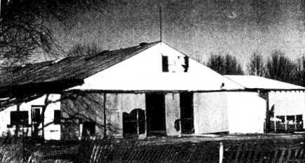
An undated photo of the Monroe Airport hangar (courtesy of Dave Jaundrill).
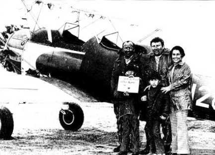
The only photo which is available showing an aircraft at Monroe Airport
was a 1970s photo of Chuck & Judy Neuchterlain in front of their Stearman at Monroe (courtesy of Dave Jaundrill).
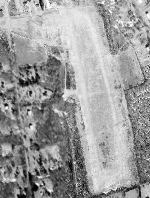
The last depiction which has been located showing Monroe Airport was on the 1973 USGS topo map.
It depicted Monroe as having a north/south unpaved runway, with a single small hangar on the northwest side.
According to a local resident, “The airport was unofficially closed by 1973.
The land was eventually sold. Eventually the airport was abandoned, the field grew over.”

The 4/12/91 USGS aerial view depicted Monroe Airport as remaining mostly clear,
but the northwest side had evidently been started to be reused as a cemetery,
and the hangar had evidently been removed.
Sean Fowler recalled, “I actually managed to fly out of the Monroe Field a few times in a powered parachute (paraplane) back in 2004.
A stern talking-to from a local officer trying to hold back laughter brought that to an end, however.
Still... it was a life dream completed.”

A 2006 aerial view by Dave looking northeast depicted 2 cemeteries & a cell phone tower occupying the site of Monroe Airport.

An 8/31/10 aerial view depicted 2 cemeteries & a cell phone tower occupying the site of Monroe Airport.
Kevin Daly observed, “If you know where to look you can still see the stonewalls just beneath the soil
exactly where Ben & young Lois buried them at night nearly 70 years ago.”
According to a local resident, “The land is now primarily Saint John's Cemetery.
It also contains a small Jewish Cemetery & a cell phone tower.
The field's windsock... I discovered the original remains of the windsock in the woods a few years back.
It's fallen but it's still in the exact location it was originally built when the airport was opened in 1940. It looks homemade.”
Faith Krysta-Johnson reported in 2014, “A few years ago, I did find the little airport, parked my car & went out into the fields.
The gentlemen who was cutting the grass stopped his machine & wanted to know if I was OK as he saw tears coming down my face.
I told him that I felt like I was at home & remembered dad tipping his wings by the house,
which meant that he was landing the plane at Monroe Airport & will be home for dinner.”
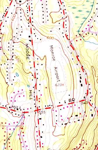
The site of Monroe Airport is located northwest of the intersection of Monroe Road & Cross Hill Road.
____________________________________________________
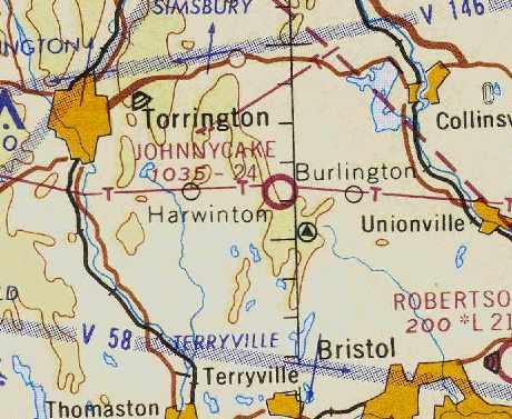
Jonnycake Airport / Mountain Meadow Airport (22B), Burlington, CT
41.77 North / 73.01 West (West of Hartford, CT)
Johnnycake Airport, as depicted on the January 1963 NY Sectional Chart (courtesy of Chris Kennedy).
This small general aviation airport may have been established at some point between 1957-60,
as it was not yet depicted at all on a 1955 aerial photo,
nor on the 1957 NY Sectional Chart (courtesy of Mike Keefe).
The earliest reference to Johnnycake Airport which has been located
came from Steve Walcott, who recalled, “We moved to Harwinton (2 miles southwest of JohnnyCake) in the late spring of 1960.
The airport was a well established airfield at that time, although the runway was turf.
Fred Pesce was Manager.
The flight shack, pumps, parking lot, and school hangar (and what would become the taxiway)
were located on the Litchfield County / Harwinton side of the line.
The general hangars, tie-downs, sock, and runway were on the Hartford County/Burlington side of the line.”
Jonnycake Airport was not yet depicted on the 1962 USGS topo map.
John Clark recalled, “Johnnycake.. I was an instructor there for about 3 months in the early 1960s.
When I was at Johnnycake I worked for Fred & the runway was probably one of the worst around.
It was turf but that is a nice word in relation to the actual condition of the runway.
Rock & rough would be a better description of it's condition.
I had a tailwheel vibrate right off of a Cessna 170 on one landing there.
I remember several mornings when we would have to go out on the runway & move the neighbor's cows off the field.”
The earliest depiction which has been located of Johnnycake Airport
was on the January 1963 NY Sectional Chart (courtesy of Chris Kennedy).
It depicted the field as having a 2,400' unpaved runway.
Steve Walcott recalled, “I began flight training at Johnnycake in 1965.
It then had a 2,800’ newly-paved runway (but no markings).
By late 1967 the south 400’ had deteriorated & the length was redesignated back to the original 2,400’.
Still no taxiway, still no markings.
The 3’ high boundary fence posts / truncated telephone poles & steel cable
were still at 2,810’ from the Runway 19 threshold
(I dinged the empenage on those in a Cessna 150 while on final approach due to wind shear that closed the airport after I landed).

The 1969 USGS topo map depicted “Johnnycake Airfield” as having a single unpaved northwest/southeast runway, with a small building at the north end.

The January 1971 NY Sectional Chart (courtesy of Chris Kennedy)
depicted Johnnycake as having a single 2,400' paved runway.
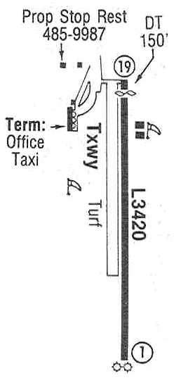
The 1987 Flight Guide (courtesy of Chris Kennedy)
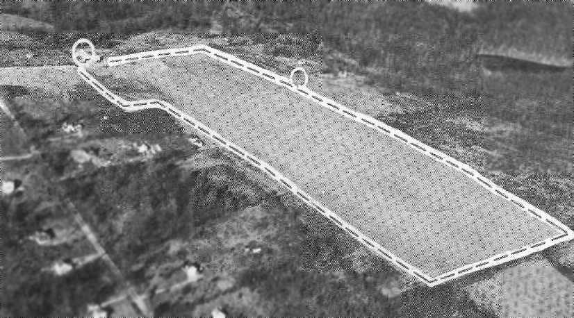
depicted Johnnycake as having a single 3,420' paved Runway 1/19, with a parallel turf taxiway on the west side.
Two hangars were depicted on the east side of the runway,
along with the Prop Stop Restaurant on the southwest side, and the terminal & office on the west side of the field.
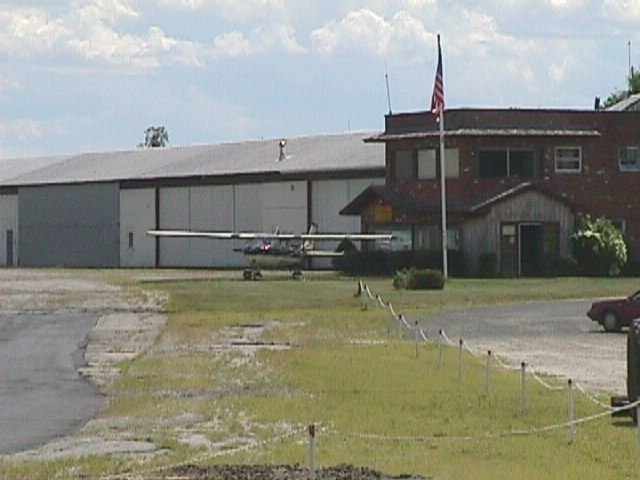
An undated (circa 1990s?) view of a Cessna 152 in front of Johnnycake's office building & hangars.
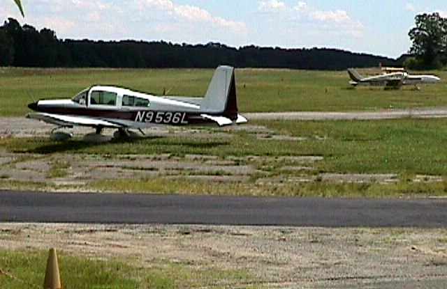
An undated (circa 1990s?) view of a Grumman American Tiger & a Piper twin at Johnnycake.
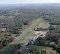
An undated (circa 1990s?) aerial view looking southeast at Johnnycake Airport.

The last photo which has been located showing aircraft at Johnnycake Airport was a 4/1/91 USGS aerial view looking southwest,
which showed over a dozen light aircraft on the ramp on the northwest side.
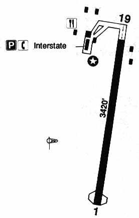
The 1993 Jeppesen Airport Directory depicted Johnnycake as having a single 3,420' paved Runway 1/19.
Several buildings were depicted on the northwest & northeast side of the runway,
including the offices of Interstate Aviation.
At some point between 1993-2004, the airfield was evidently renamed “Mountain Meadow” Airport.
In its last year of being listed in the FAA Airport/Facility Directory (2004),
Mountain Meadow Airport was described as having a single 3,420' asphalt Runway 1/19.
The field was said to be home to a total of 23 aircraft (21 single-engine & 2 multi-engine),
and it was said to conduct an average of 36 takeoffs or landings per day.
According to the Squadron One Flying Club, Mountain Meadow Airport was reported closed on 4/1/2004.
“Rumor has it that the two owners of the airport had an ongoing dispute about the property
and this is the sad outcome.”
An article entited "A Big Debate Over A Tiny Airport" by Don Stacom
appeared in the 5/10/04 issue of the Hartford Courant.
It described efforts to reopen the field.
It reported that Johnnycake Mountain Meadows Airport's flight school & fuel depot had closed years ago.
Vincent Scarano, manager of the FAA's New England Region airports division,
said “Airports like Johnnycake are important to aviation.
If you shut them down, those pilots & their planes go somewhere else that may already be congested.”
The FAA & the state Department of Transportation were reported to be holding out the lure of millions of dollars in aid
if the towns of Burlington & Harwinton were to buy Johnnycake &reopen it as a municipal airport.
But there's a problem: airport owner Richard Miller no longer wanted an airport on his property,
and he was refusing to sell.
He ridiculed the defense that it could be an engine for regional business growth.
"It's been there 50 years, and what do you have?
The Landing Zone & the Countryside," he said,
referring to two nearby restaurants that are popular with visiting pilots. "That's it."
Miller's position had municipal leaders talking about perhaps taking his land by eminent domain -
a prospect that unsettled even some of Johnnycake's supporters.
The FAA was interested in Johnnycake because of its location.
The agency's National Plan of Integrated Airports listed about 3,000 airports
that it considers significant to America's aviation system,
and Johnnycake was on it.
The field is one of only 15 Connecticut airports on the list, and the only one near Litchfield County.
Buying Johnnycake, local pilots said, would be a sensible use of public money.
But acquiring Johnnycake would be expensive.
Burlington First Selectman Ted Scheidel estimated Miller's 237 acres were worth $4.7 million,
and pilots said that improving the facilities might run another $1 million.
The price could climb higher if Johnnycake's western edge, which was owned by Frederick Pesce, was added.
As much as 95 percent of the cost could be covered by the FAA,
with the CT DOT paying another 3.75 percent, said Richard Jaworski, a DOT transportation engineer.
The FAA, however, spends only $2-3 million a year on municipal airports in Connecticut,
and that's usually for improvements, not acquisitions.
Scarano acknowledged that the FAA hasn't subsidized the purchase of an airport in New England for as long as he can remember,
and that a potential $5-6 million price tag would be double the agency's yearly budget for municipal airport work in the state.
"We seldom buy an airport. But that doesn't necessarily mean anything," he said.
"It might be that the location would make it interesting to us."
Bill Thomas, president of the Simsbury Flying Club, said saving Johnnycake would benefit the state as a whole.
"As Bradley is growing, they'd prefer not to also have an influx of aircraft," he said.
"Aviation has an infrastructure - the fewer airports, the more planes will squeeze into the ones left."
Mountain Meadow was depicted as an abandoned airfield on the 2005 NY Sectional Chart.
A 2005 aerial photo depicted closed-runway “X”s painted on the runway,
and no aircraft on the field.

A circa 2006 aerial view looking south at Mountain Meadow Airport showed that the runway & hangar still remained intact,
but land had been cleared to the south of the hangar for some type of construction.

A 3/29/12 aerial view looking southwest showed that the runway & buildings at Jonnycake Airport remained intact though deteriorated.
Ian Maher reported of Jonnycake Aiport in 2013, “I drive by it nearly every day.
There are no planes; the last aircraft that I saw there was a helicopter being sold in front of Countryside last year.
For a while someone was landing their helicopter there, which was a very modern looking one.
About 6 years ago, the area seemed to be used for cargo of some kind as well.
Helicopters could be seen daily carrying crates over the woods & back to the airport.
There has been a sense of mystery any time that the airport is actually used as it was once intended now.
Corn is grown in the summer months at the airfield, and the runway is difficult to see from the road.
Construction equipment is still there for building the condos, however I do not know if that project has made any actual progress.”
Johnnycake Airport is located southwest of the intersection of Route 4 & Johnnycake Mountain Road.
____________________________________________________
41.44 North / 72.99 West (Northwest of New Haven, CT)

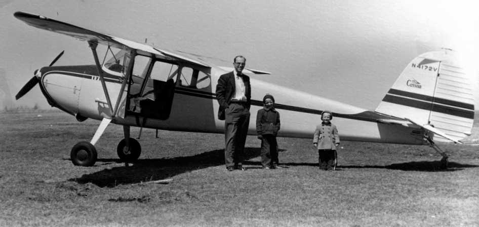
A 1927 photo of Ernest Markham & two unidentified boys in front of a Waco 10 biplane at Bethany Airport (courtesy of Linda Markham Scialabba).
The date of construction of this small general aviation airport has not been determined.
The earliest depiction of the Bethany Airport which has been located
was a 1927 photo of an unidentified biplane at Bethany Airport (courtesy of Linda Markham Scialabba).
The photo pictured Linda's grandfather, Ernest Markham, and two unidentified boys in front of a biplane marked with “Hill & Somers”.
Linda noted, “My uncle tells me they were some type of business, he is not sure if they owned the airport.
My grandfather... worked at Bethany Airport from 1927-28; he may have been a flight instructor there.”
According to Richard Turnure, Gus Graf [his wife's grandfather] “helped found the airport.”
According to Tom O'Connell, “Bethany Airport was rumored to be the 2nd oldest airport in New England after Boston.
It was supposed to have been an auxiliary field for the first planes from Newark to Boston.”

An photo of Charles Lindbergh landing at Bethany Airport in his Ryan “Spirit of St. Louis”.
Bethany Airport, as depicted on the Boston Chamber of Commerce's
1931 "Airports & Landing Fields of New England" (courtesy of Chris Kennedy).
It described Bethany as a Department of Commerce Intermediate Field.
The field was said to consist of a 33-acre irregularly-shaped sod field, measuring 2,400' x 1,000',
with the entire field available for flying operations.
The field was also said to have a 100' x 80' hangar.
The Airport Directory Company's 1933 Airport Directory (according to Chris Kennedy)
described Bethany as a auxiliary airfield,
serving as the Department of Commerce's Intermediate Field, Site 9 along the New York - Boston Airway.
The airfield was described as consisting of an irregularly-shaped 36 acre plot.
According to John Boyce, Bethany “was a historic airport, being a stop on Contract Air Mail 1 on the Boston-New York run.”

A 1934 aerial view of Bethany Airport, taken by the Fairchild Aerial Survey Company (courtesy of Chris Kennedy).

A close-up from the 1934 aerial view of Bethany Airport (courtesy of Chris Kennedy),
showing the unusual airport marker, and the hangar marked with “Bethany” on the roof.
Bobs Macaleenan recalled, “I flew with Jack & Chappy Lenox back in 1929, when I was 7. That is when I started flying.
We used to have Fly in breakfasts at Bethany in 1936-38.
I remember the circle drawn in the middle of the field & a prize for whoever could land & stop in it.”

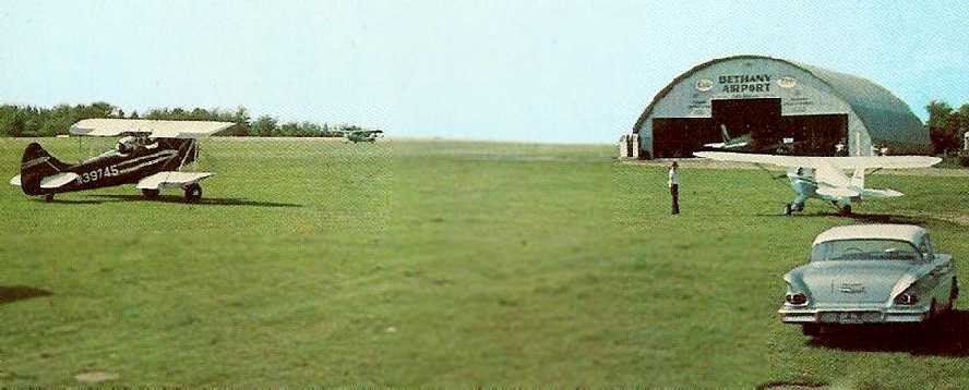
An aerial view looking north at Bethany Airport,
from the Airport Directory Company's 1937 Airport Directory (courtesy of Bob Rambo).
The directory described Bethany as a commercial airport having 2 sod runways: 2,450' north/south & 1,400' east/west.
A single hangar & some other small buildings were depicted along the east side of the field.
According to Ron Rex, "It was very well known in the 1930s
and many famous pilots visited there...Bert Acosta for one."

An undated aerial view looking northeast at the Bethany Air Service hangar.
An aerial view looking northwest at Bethany Airport,
from the Airport Directory Company's 1941 Airport Directory (courtesy of Chris Kennedy).
The directory described Bethany as a commercial airport consisting of a 52 acre rectangular field, measuring 2,280' north/south.
A single hangar & some other small buildings were depicted along the east side of the field.
Bethany Airport was depicted on the November 1942 Regional Aeronautical Chart (according to Chris Kennedy).
The April 1944 US Army/Navy Directory of Airfields (courtesy of Ken Mercer)
described Bethany Airport as having a 2,100' unpaved runway,

Bethany was depicted as a commercial or municipal airport on the 1945 NY Sectional Chart.
According to John Boyce, “The original hangar burned down some time after the war.”
A 1949 aerial photo showed the remains of the original hangar, lost in a fire a few years before.
Miles Reese recalled, “My father learned to fly at Bethany in a Aeronca 7AC.
He had taken a ride at the airport for $3 & got the bug. I think that was in 1953.
He had kept a Taylorcraft BC12D on the south end of the airport.
Al Porto did own the airport. The 'FBO' was owned by Bob Jones & his wife.
Bob had taken off in a pretty new Baron that had been bought for charter work. He crashed.
He was a very proficient pilot but was very troubled at that point of time.
There was a huge push to shut down the airport by then WNHC, Channel 8 in New Haven CT.
The tower that was erected was thought to be a potential problem but Robertson in Bristol CT
has a taller tower adjoining it closer to the airport than Bethany's was.”

The 1954 USGS topo map depicted Bethany Airport as an irregularly shaped clearing, with a few small buildings,
but did not depict any runways.
A 1955 aerial photo showed the remains of the original hangar, still not replaced with another structure.
According to John Boyce, “The original hangar... was replaced with the present structure, a Quonset hut type.”
An undated photo of Henry Jones & 2 children in front of a Cessna 170 at Bethany Airport.
AeroMotiveDist recalled, “Bethany Airport... I soloed in a 65 hp Aeronca Champ in 1958, I was 18 years old.”

A summer 1958 aerial view by Edd Weninger looking east at Bethany Airport.
Edd recalled, “I learned to fly & soloed at Bethany Airport, 1958.”

A 1958 photo (courtesy of Edd Weninger) of his father, “Gus” Weninger
“hopping passengers” in a Waco UPF-7 biplane at Bethany Airport.

A 1958 photo (courtesy of Edd Weninger) of Edd Weninger with his Aeronca 7AC at Bethany Airport,
with the “burger joint just across the fence” visible in the background,
and a sign pointing out “Airplane rides $2.50”.

A 1958 photo by Edd Weninger of “one of the rental [Aeronca] 7ACs landing” at Bethany Airport.
A circa early 1960s view looking northwest at a biplane & several monoplanes around the Bethany Airport hangar (courtesy of Jonathan Westerling).
The caption described Bethany as the “Oldest airport in continuous operation in New England.”
Jonathan noted that the “Age of this card is estimated as circa 1960, because the car shown is a 1958 Chevrolet,
and there is no Zip Code on the card (zip Codes were mandated in 1965).”
The 1962 AOPA Airport Directory described Bethany Airport
as having a single 2,800' turf Runway 18/36.
The field was said to offer fuel, repairs, hangars, tiedowns, and charter.
The operator was listed as Albert Porto.
Greg Ploski recalled, “I learned to fly at Bethany Airport in 1964 & have the logs of a Aeronca 7AC 2737E.”
The last photo which has been located showing Bethany Airport in operation was a 1965 aerial view (from the CT State Library, via Chris Kennedy).
It depicted Bethany as having a single north/south grass runway,
with the Quonset hut hangar on the east side of the field, and 3 single-engine aircraft on the east side of the field.

The last aeronautical chart depiction which has been located of Bethany Airport was on the 1965 NY Sectional Chart.
It depicted Bethany as having a 2,400' unpaved runway.
John Boyce recalled, “I was flying out of Bethany when it closed toward the end of 1965.
It was the oldest airport in New England in continuous operation.
Clarence Chamberlain was another one of the great old-timers who flew there.
Another notable was William F. Buckley, who earned his private certificate there while a student at Yale.
Al Porto was the last Fixed Base Operator to operate there, with a lease.
The land was owned by Triangle Publications. and the rent Al paid didn't even cover the taxes, so they bought him out.
In its last years, the airport was home to the Nutmeg Soaring Association, which thereupon moved to Johnnycake.
After a lot bickering, the town bought the airport for $250,000.
The plan was to develop an industrial park to boost the tax base. It never happened.”
Frank Podgwaite recalled, “I had my first airplane ride with my Dad at the Bethany Airport prior to its closure in 1966.”
A single large white closed-airport “X” was visible in between the hangar & runway on a 1966 aerial photo.
The Bethany Airport was definitely closed by 1967,
as it was no longer listed among active airports in the 1967 AOPA Airport Directory (according to Chris Kennedy).
Ron Rex reported in 2004, "The last time I was there, probably 20 years ago,
there were still some original hangars in existence."
According to Ed Walsh (who moved to Bethany in 1993), the Bethany Airport had closed as
"The airport surrendered air rights so a television/radio tower could be put up not far away down the hill."
Walsh continued, "The airfield has had horse show pens & exhibit areas,
a golf driving range & soccer field built on it in the early 1990s
and a recycling center was put near the hangar in 1995."
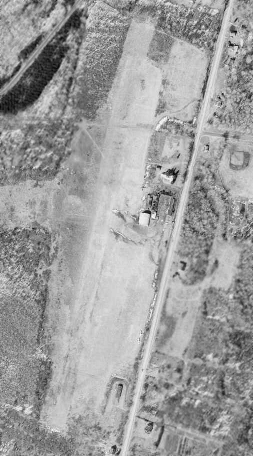
Remarkably, the 1991 USGS aerial photo showed that after more than 54 years
the former airfield appeared to remain almost completely intact,
with the areas of the north/south & east/west runways remaining largely clear.
Most significantly, what appeared to be the original hangar remained standing (the white building just right of the center of the photo)
and even the circular airfield marker (used in the 1930s & 1940s to mark a grass airfield)
also appeared to remain (in the center of the photo).
Ed Walsh reported in 2005, "The hangar is now a DOT office & storage area.
You could never land a plane of any size there anymore."

A circa 2006 aerial view looking north at the former Bethany Airport hangar.

A 2008 photo by Matt Baker of the former Bethany Airport hangar.
According to Matt, “It was used until recently as a town garage but will soon be converted for use as recreation space for the town of Bethany.”
John Boyce reported in 2009 of the Bethany Airport site, “Most of the open space is used for horse-oriented activities.
It is also the home of our recycling facility, the Highway Department, and the Bethany Volunteer Firemen's Association.
There is a mattress factory & a driving range, too. Hardly what was envisaged.
[The hangar] is nearing the end of its days. It is badly rusted-out where the arches join the concrete footings.”
A 9/19/13 aerial photo showed the Bethany hangar remained standing.
Bethany resident Mark Scott reported in 2014, “Volunteers have torn down the old Quonset hangar which was falling down anyway.
The old hangar was literally falling down. It was very rusted out.”
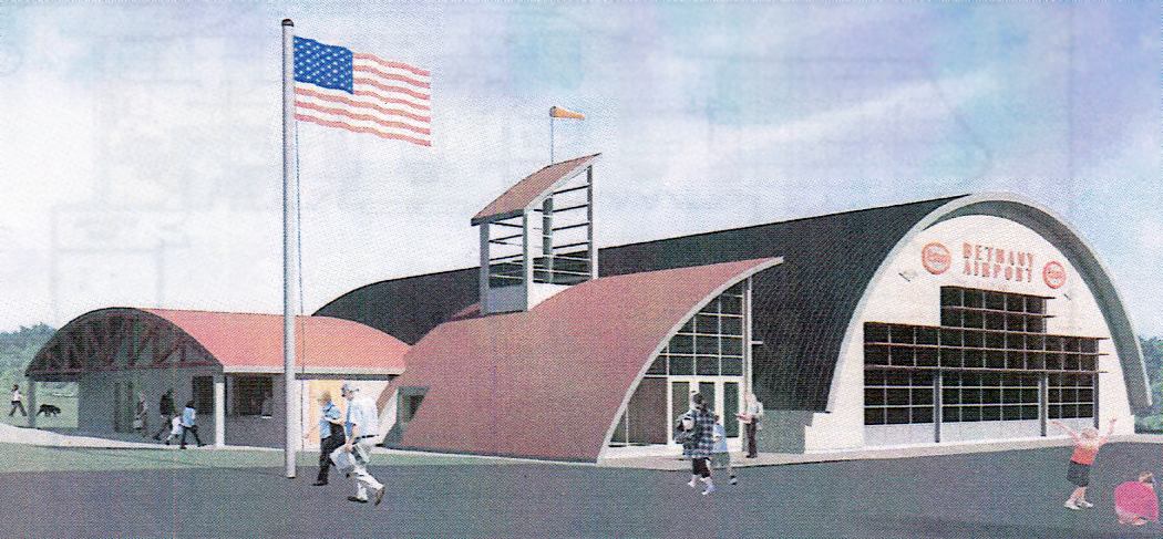
A 2014 rendering of the planned “Bethany Airport Community Center” (courtesy of Mark Scott).
Mark reported, “The town historical committee & volunteers are going to build a town community center
in the form of a Quonset hangar with large doors & a side building.
The old airport property is used for many town activities. The community center is a good use of the space.
The best part is that we found the old airmail arrow depicted clearly in one of [the preceding] photos.
We plan to uncover the grass & restore it.”
![]()
A 2014 photo by Mark Scott looking southwest at the remains of Bethany Airport's 80 year old concrete airmail arrow marker.
Mark reported, “I hope to uncover it soon.”
Mark Scott reported in December 2014, “The Bethany Connecticut Airport Community Center being built in the design look of the old Quonset hangar is now underway.”

A 6/5/16 photo by Mark Scott of the remains which were uncovered that day of Bethany Airport's 80 year old concrete airmail arrow marker.
Mark reported, “I am on a committee that is recreating the old Bethany Airport hangar as a community center.
Last Saturday the committee uncovered this concrete directional arrow at the old Bethany Airport.
It's really cool. It was made in the 1920s for air mail pilot navigation. It is 70' long. The tail points towards New York, the tip towards Hartford.
This is about the time the arrows were made obsolete by radio navigation. We think it has been covered for about 40 years.
It is quite broken up from all the frost heaving but it is all there. We are not sure if we will leave it as is or restore it.
We are looking for donations to erect a suitable fence to protect it & a plaque about its history.”
The site of Bethany Airport is located west of the intersection of Amity Road & Munson Road.
Thanks to Ron Rex for pointing out this airfield.
____________________________________________________
Since this site was first put on the web in 1999, its popularity has grown tremendously.
That has caused it to often exceed bandwidth limitations
set by the company which I pay to host it on the web.
If the total quantity of material on this site is to continue to grow,
it will require ever-increasing funding to pay its expenses.
Therefore, I request financial contributions from site visitors,
to help defray the increasing costs of the site
and ensure that it continues to be available & to grow.
What would you pay for a good aviation magazine, or a good aviation book?
Please consider a donation of an equivalent amount, at the least.
This site is not supported by commercial advertising –
it is purely supported by donations.
If you enjoy the site, and would like to make a financial contribution,
you
may use a credit card via
![]() ,
using one of 2 methods:
,
using one of 2 methods:
To make a one-time donation of an amount of your choice:
Or you can sign up for a $10 monthly subscription to help support the site on an ongoing basis:
Or if you prefer to contact me directly concerning a contribution (for a mailing address to send a check),
please contact me at: paulandterryfreeman@gmail.com
If you enjoy this web site, please support it with a financial contribution.
please contact me at: paulandterryfreeman@gmail.com
If you enjoy this web site, please support it with a financial contribution.
____________________________________________________
This site covers airfields in all 50 states.