
Abandoned & Little-Known Airfields:
Southwestern Illinois
© 2002, © 2016 by Paul Freeman. Revised 9/16/16.
This site covers airfields in all 50 states: Click here for the site's main menu.
The SW IL page of this website are sponsored by The Greater St. Louis Air and Space Museum.
____________________________________________________
Please consider a financial contribution to support the continued growth & operation of this site.
Belleville Airport (added 7/17/16) - Central Airport (revised 1/30/16) - Collinsville Airport / Downtown Airpark (revised 7/5/16) - Cyril Lebert Airport / Flying L Airport (revised 1/31/16)
Lakeview Airport / Lakeside Airport / Nichols Airport (revised 8/10/16) - Parks College Airport (revised 8/10/16)
(Original) Springfield Municipal Airport / Southwest Airport (revised 9/16/16) - WLS Airport (added 8/28/14)
____________________________________________________
Belleville Airport, Belleville, IL
38.579, -89.988 (East of St. Louis, MO)

Belleville Airport, as depicted on the May 1945 Cincinnati Sectional Chart (courtesy of Ed Whinnery).
Photo of the airport has not been located.
According to Ed Whinnery, “Local newspapers indicate that the Belleville Airport was in operation during the years 1941-1953.
It is possible that it started operations as a Restricted Landing Area (RLA) field.
On 7/11/44 a Belleville group interested in commercial aviation announced that it had received permission
from the IL State Aeronautics Commission to set up a 75-acre 2-runway airport 4 miles north of Belleville.
The sponsors said the airport with sod runways would be ready for operation in about 2 weeks.
Announcement by the group of the formation Belleville Airport, Inc., with a capitalization of $30,000, and of plans for the field,
were made when officers of the corporation were elected at a meeting at Belleville.
Dewey Holland, until recently an instructor at Shiloh Valley Airport, near Scott Field, was elected President.
Construction of a hangar at the airport site, on Highway 159, started yesterday.
Grading of 2 runways, 2,200' long, will be completed this week.
The group has 4 small passenger planes, and plans to begin operation immediately training pilots & making charter flights.”
The earliest depiction which has been located of Belleville Airport was on the May 1945 Cincinnati Sectional Chart (courtesy of Ed Whinnery).
Ed Whinnery noted, “This chart shows the airport located southeast of the junction of Highway 50 & Highway 159.”

In contrast to the 1945 depiction, a 1953 map (courtesy of Ed Whinnery) depicted Belleville Airport slightly to the west, to the southwest of the intersection of Highway 50 & Highway 159.
According to Ed Whinnery, “On 9/30/49 it was announced that an air show would be held Saturday & Sunday at the Belleville Airport.
Featured at the air show would be the 4 Cole brothers, one of whom was voted as aerobatic champion of the world in a poll of commercial pilots.
Included in the 10 acts put on by the barnstorming group are trio formation flying & acrobatics, duo maneuvers,
a solo display by one of the smallest stunt planes in the business & a man-on-the-wing act.
All 4 of the brothers, Duane Lester, Arnold & Marion flew with the armed services in the war.
Duane is the holder of world’s record in a plane flown upside down
and Marion who will do the solo stunting, was voted as the top aerobatic flyer by the commercial pilots polled by the Aeronautic Society of America.”
According to Ed Whinnery, “On 4/26/50 it was announced that Belleville Airport's east/west runway was unsafe for use during wet weather.”

The last aeronautical chart depiction which has been located of Belleville Airport was on the June 1950 Cincinnati Sectional Chart.
It depicted Belleville Airport as having a 3,300' unpaved runway.
According to Ed Whinnery, “In September 1950 the city of Belleville considered constructing a municipal airport suitable for feeder line & cargo planes.
The present privately-owned Belleville Airport could be purchased for $125,000.
The field occupied 180 acres on Highway 159. It had one hangar & a shop & 2 sod runways.
The city later decided not to establish a municipal airport.”
According to Ed Whinnery, “On 3/14/52 Bellville Alderman Calvin Isselhardt, a Navy reservist, announced that he had been ordered to report for extended active duty.
Isselhardt, 30 years old, served 3.5 years in World War II as a Navy flying instructor.
He was manager of the Belleville Airport at the time.”
This presumably may have been the end of operations of Belleville Airport.
Belleville Airport was evidently closed by 1954, as it was no longer depicted on the 1954 USGS topo map
nor on the 1955 Cincinnati Sectional Chart.
A 1988 aerial view showed no trace of Belleville Airport, with the area having been heavily redeveloped.

A 2016 aerial view showed no trace remaining of Belleville Airport.
Thanks to Ed Whinnery for pointing out this airfield.
____________________________________________________
Collinsville Airport / Downtown Airpark, Collinsville, IL
38.655, -90.054 (East of St. Louis, MO)

Collinsville Airport, as depicted in an undated aerial photo from a circa 1959-61 IL Airport Directory (courtesy of Ed Whinnery).
According to Ed Whinnery, “I don’t know when the airport first opened,
but the Collinsville Airport was listed in the 1953 IL Airport Directory as a Restricted Landing Area (RLA) field.
The owner at the time was Ardell Davinroy. The north/south runway was 1,400’.”
Collinsville Airport was not yet depicted on the June 1955 Cincinnati Sectional Chart.
The runway length of Collinsville Airport had decreased slightly to 1,200' in the 1958 IL Airport Directory (according to Ed Whinnery).
According to Ed Whinnery, “On 12/30/58 the Collinsville RLA field became Collinsville Airport, a privately-owned public[-use] airport.
Claud Cleveland, owner & operator, received a commercial certificate of operation issued by the State of IL Department of Aeronautics.
The airport consisted of 135 acres fronting U.S. Highways 40-66.
Installations were to include a 3,300' all-weather strip, a shop, operations office, tiedown area & repair & refueling facilities.
Plans called for a second strip, which was under construction, lighting for night flying & individual T-hangars for private planes.
Cleveland, a former Collinsville automobile dealer & flying enthusiast, had obtained a sales agency for Cessna aircraft & would provide flight instruction.”
The earliest photo which has been located of Collinsville Airport was an undated aerial photo from a circa 1959-61 IL Airport Directory (courtesy of Ed Whinnery).
It depicted Collinsville Airport as having a 2,000' paved north/south runway, and a 1,900' unpaved northwest/southeast crosswind runway.
Several light aircraft were parked on the northwest side, but no buildings were visible.
The directory listed the owner as Claude Cleveland & the manager as Ken Cothern.

The earliest aeronautical chart depiction which has been located of Collinsville Airport was on the January 1960 Cincinnati Sectional Chart.
It depicted Collinsville Airport as having a single north/south paved 2,000' runway.
According to Ed Whinnery, the airport was “renamed St. Louis Downtown Airpark in 1963.”

An undated aerial view of Collinsville Airport from the 1966 IL Airport Directory (courtesy of Ed Whinnery).
It listed the operator/manager as S.W. Sisk. The north/south runway had been extended to 2,800’ at some point between 1962–66.
There wee at least 25 light aircraft visible tied down.

The 1968 USGS topo map depicted Downtown Airpark as having a north/south paved runway & an unpaved northwest/southeast runway.

The last aeronautical chart depiction which has been located of Downtown Airpark was on the August 1968 Cincinnati Sectional Chart.
The length of the paved runway had increased slightly to 2,800'.
An October 1968 aerial view looking north at St. Louis Downtown Airpark (courtesy of Ed Whinnery).
Ed Whinnery noted, “The northwest/southeast runway was not in use in 1968 & 1969.”

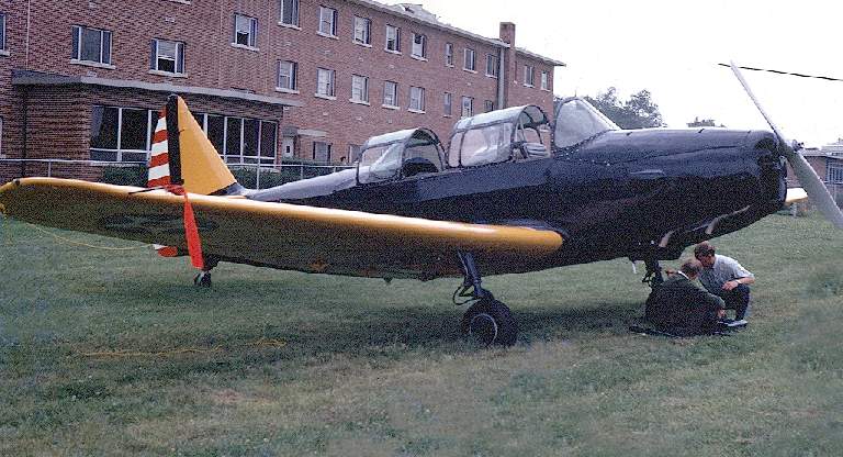
An October 1968 photo of a U.S. Army National Guard de Havilland U-6A (DHC-2) Beaver landing towards the south at St. Louis Downtown Airpark (courtesy of Ed Whinnery).
The aircraft next to the hangar appears to be a North American Harvard AT-6.
Jim Meyer recalled, “The airport (I remember it from the late 1960s) used to be located right across the street (to the south) from the old Grandpas Store.”

The last depiction which has been located of Downtown Airpark was on the 1985 USGS topo map.

Downtown Airpark was evidently closed (for reasons unknown) at some point between 1968-88.
as a 1988 USGS aerial view looking southeast showed the paved runway remains were quite deteriorated,
and a building had been built over the north end of the runway.

A 2015 aerial view looking southeast showed the majority of the site of Downtown Airpark remained clear.
The site of Downtown Airpark is located southeast of the intersection of Collinsville Road & Ramey Drive.
Thanks to Jim Meyer for pointing out this airfield.
____________________________________________________
Central Airport, Centralia, IL
38.58, -89.12 (East of St. Louis, MO)

Central Airport (north of Centralia), as depicted on the 1947 Cincinnati Sectional Chart (courtesy of Jerry Spear).
This small general aviation airport on the north side of Centralia was evidently established at some point between 1946-47
(like hundreds of other small airports in the post-WW2 general aviation boom),
as it was not yet depicted on the October 1946 Cincinnati Sectional Chart (courtesy of Dick Merrill).
The earliest depiction which has been located of Central Airport was on the 1947 Cincinnati Sectional Chart (courtesy of Jerry Spear).
Note that it also depicted the very similarly-named Centralia Airport only a few miles to the southeast, which must have caused confusion.

The last depiction which has been located of Central Airport was on the June 1955 Cincinnati Sectional Chart.
It depicted Central Airport as having a 2,600' unpaved runway.
Central Airport was evidently closed (for reasons unknown) at some point between 1955-60,
as it was no longer depicted on the January 1960 Cincinnati Sectional Chart.
Central Airport was no longer depicted on the 1971 USGS topo map.
A 1998 USGS aerial view did not depict any recognizable trace of an airfield.

A 2015 aerial view showed that the presumed site of Central Airport – the north/south field, remained clear.
There did not appear to be any airport-related buildings remaining on the site.
The site of Central Airport is located southwest of the terminus of County Road 750 North & Old 51st Street.
Thanks to Jerry Spear for pointing out this airfield.
____________________________________________________
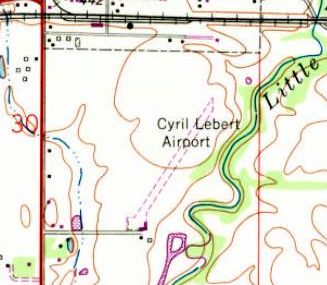
Cyril Lebert Airport / Flying L Airport (3H5), Lebanon, IL
38.59, -89.8 (East of St. Louis, MO)

Cyril Lebert Airport, as depicted on the May 1945 Cincinnati Sectional Chart.
According to Ed Whinnery, “An eleven-year old local boy saw his first airplane in 1917, and it was love at first sight.
The plane was one of the first to locate at the new U.S. Army base known as Scott Field. The boy’s name was Henry Lebert.
After school every day & his newspapers all delivered, he would ride his bicycle to a point about 2 miles southwest of Lebanon to view the dirigibles & biplanes flying in the area.
Henry had a dream of being part of this exciting thing called aviation.
Henry attended Parks Air College, where he was graduated in 1929, taking all 23 of the required courses & soloing at the flight school in a Travel Air OX-5 biplane.
Henry learned to pack parachutes while attending Parks Air College at Cahokia.
He received a CAA rating of Master Parachute Rigger & Instructor.
Over the years, he packed ‘chutes for many famous aviators including Col James Doolittle of Tokyo Raid fame.
Col. Doolittle flew for Shell Oil Co. at the time of their association.
Lebert did a lot of flying in the 1930s & always dreamed of owning his own airport.
The advent of World War II put his dream on hold until after the duration.”
Lebert Airport was not yet depicted on the 1943 Cincinnati Sectional Chart.
Ed continued, “It was during 1943, as a Navy instructor, that Henry noticed a farm south of Lebanon that had come up for sale.
It consisted of 175 acres & was located at Route 4 (then numbered 43) & South Street (now Southern Drive), just across the B&O railroad tracks.
Henry had planned to install his brother Cyril as the manager of his airport when the war ended.
Cyril was a T/SGT in the US Army Air Force & served as a radio operator on a Boeing B-17-G Flying Fortress.
Cyril was killed when his bomber was hit by enemy flak & crashed near Vlessendijk, Raalte, Holland on 1/11/44.
Despite this loss, plans continued to get the airport open as soon as possible.
On 12/8/44, Henry received permission from the state of IL Aeronautics Commission to start his airport on the Lebert farm.”
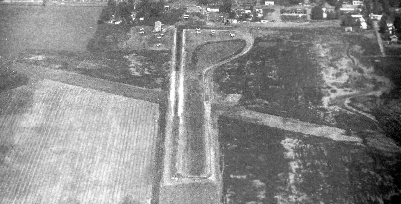
The earliest depiction which has been located of Cyril Lebert Airport was on the May 1945 Cincinnati Sectional Chart.
According to Ed Whinnery, “By mid-1945, as WWII was winding down, two turf runways, consisting of a 2,200' north/south strip & an 1,800' east/west strip
wide were laid out & two 3-place hangars & one large hangar that was used as an aircraft rebuilding & repair shop were built.
By this time, aircraft fuel had become plentiful again & was on hand in time for opening day.
Everything was in place as fall arrived. The Cyril Lebert Airport was open for business as a public / general aviation airport.”
Ed continued, “The airport manager would be Carl Coley, a former Army instructor; Jay Williams operated the flying service;
Robert Willard & Leonard Nevener would manage the rebuilding & repair shop.
The Ideal Parachute Loft operated by Henry was also included in the operation.
Parachutes were packed on a regular basis & delivered to airports all over Southern IL.”
Ed continued, “The airport office & hangars were located on the northwest side of the field.
The airport offered flight training, 80 octane fuel, minor mechanical repair, passenger rides, aircraft charter & rental services, and aircraft tie-down & hangar rental.
The airport was also home to 2 aircraft dealerships, for Ercoupe & Stinson planes.
Like hundreds of other small airports in the post-WW2 aviation boom, there was no airport beacon, control tower, runway lights or radio.
The pilots had to be alert and take a visual check for other air traffic when taking off & landing.”

An Autumn 1945 aerial view looking northwest at Cyril Lebert Airport (courtesy of Ed Whinnery).

A 6/14/46 USGS aerial view showed Cyril Lebert Airport to have 2 perpendicular grass runways,
with 3 single-engine aircraft visible on the northwest side of the field, and another on the north/south runway.

A 1946 photo of Lew Whinnery & a flying school Piper J3 Cub at the Cyril Lebert Airport (courtesy of Ed Whinnery).
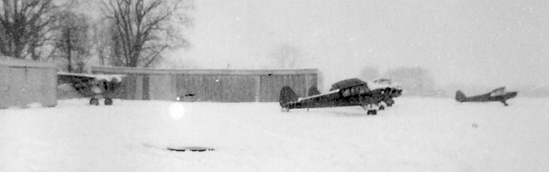
A February 1947 view of a Winter scene at Cyril Lebert Airport, looking east at a Curtiss Robin & Piper Cubs (courtesy of Ed Whinnery).

A February 1947 photo looking south at a Winter scene at Cyril Lebert Airport (courtesy of Ed Whinnery).
Ed Whinnery observed, “The poster on the tree says 'Attention Veterans', for flight training under the G.I. Bill.
The sign on the building says 'Office'. Shell aviation fuel pump inside the fence.
The small building on the right had a 'Restroom' sign: fancy name for an outhouse!”

A 2/8/47 advertising card from the Lebanon Flying Service (courtesy of Ed Whinnery).

A 7/22/47 photo of flight instructors in front of a Waco biplane at the Cyril Lebert Airport (courtesy of Ed Whinnery).

A circa mid-1940s advertisement for Lebert Airport (courtesy of Ed Whinnery).
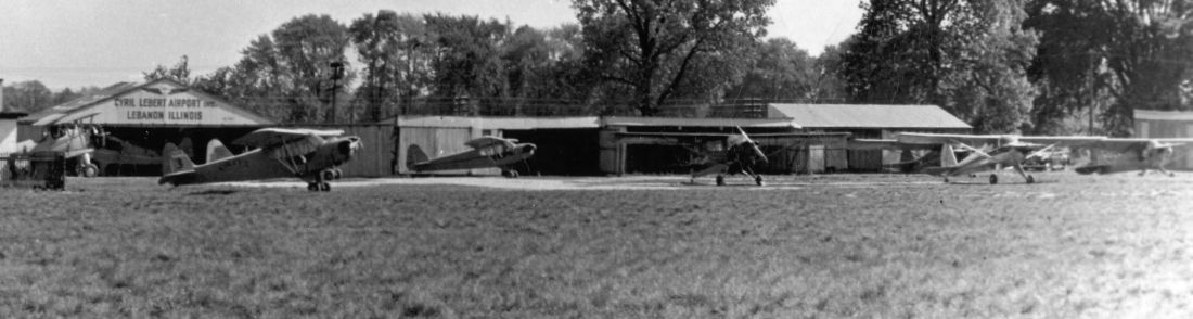
A circa 1947 view looking north at the Cyril Lebert Airport, showing the airport office, large hangar, 3 other hangars and the workshop (courtesy of Ed Whinnery).
Eight aircraft are on the field & one is in the main workshop. Aircraft are Waco, Piper Cubs & a Luscombe.

A circa late 1940s newspaper ad for Lebert Airport (courtesy of Ed Whinnery).

A circa late 1940s photo of an unidentified young lady in front of a Piper J-3 Cub at Lebert Airport (courtesy of Ed Whinnery).

A circa late 1940s photo of the large hangar (“Hangar 1”) that also functioned as a workshop with “Lebert” painted on the roof
and “Cyril Lebert Airport Inc, Lebanon Illinois” on the south side of the hangar (courtesy of Ed Whinnery).
The white structure in the background was the parachute drying tower.

A circa late 1940s photo of a shiny natural metal Ercoupe at Cyril Lebert Airport (courtesy of Ed Whinnery),
with the airport office building & large hangar in the background.

A 1948 photo of Lew Whinnery & his Curtiss Robin B (marked with “Ideal Parachute Service”) at Cyril Lebert Airport (courtesy of Ed Whinnery).

The business card for Ideal Parachute Service, Cyril Lebert Airport (courtesy of Ed Whinnery).

A circa 1949 photo of Lew Whinnery (center) & a Mooney Mite at Cyril Lebert Airport (courtesy of Ed Whinnery).
Ed continued, “A restaurant was opened in the old house that sat on the property, the former Gartside home,
and was managed by Loretta Wick & later on by Fay & Edna Battoe.
The airport qualified under the G.I. Bill of Rights, and it wasn’t long before more than 40 students were registered in the flight program.
There was no shortage of students, all airports in the metro-east area offered flight instruction.
Piper J-3 Cubs were used for flight training.
Other pilots at the airport included Lewis 'Lew' Whinnery, who operated an aerial photography business & also delivered the freshly-packed parachutes.”

The 1949 USGS topo map depicted Cyril Lebert Airport as having 2 perpendicular unpaved runways, labeled simply as “Landing Field”,
with several buildings along the north side.
Ed continued, “The Lebanon Civil Air Patrol Squadron met at Lebert Airport on Sunday afternoons.
In 1947, a new manager was named for the airport, Phil Zimpani, a former instructor of Wings of Mercy Airport at Belleville.
Carl Coley, the former manager, left to open Club 50, a tavern on West St. Louis.
Mr. Zimpani stayed on as manager until 1949, when he left to move back to his home state of OH.
He was replaced by Earl Shaffer, who remained until 1953 when the flight service was sold to the Ahring family of Collinsville.
The restaurant closed in 1951.
A senior squadron [Civil Air Patrol] existed in 1952.”

The 1953 IL Airport Directory (courtesy of Ed Whinnery) depicted Lebert Airport as having 2 perpendicular grass runways.
But Ed Whinnery reported, “The correct length of the East/West runway was 1,800 feet.”
The last depiction which has been located of Cyril Lebert Airport was an undated aerial view from the 1958 IL Airport Directory (courtesy of Ed Whinnery).
Ed Whinnery observed, “The East/West runway was no longer shown.
The office building & hangars were located on the northwest side of the property.”
Ed Whinnery continued, “The Ahring family remained until 1958 when their son, Orville, was killed by a B&O train at the former South Herman Street crossing.
Richard Hollenkamp took over as airport manager after Orville Ahring’s death. After several years of short-term managers, Henry closed the airport.
By 1959, after several years of short-term managers, aviation was changing.
No longer was it profitable to operate small general aviation airports.
The G.I. Bill of Rights ended in the mid-1950’s, slowing the flow of new students.
The new FAA rules also made public airport operations more difficult.
Henry Lebert decided to close Cyril Lebert Airport in 1959 or 1960.”
However, Ed Whinnery reported that it “changed to a private restricted airport which was known as Lebert Flying L Airport.
Lebert retained ownership. When Lebert closed the Cyril Lebert Airport,
he moved it further south on his farm & it was changed from a public general aviation airport to a private restricted airport & renamed the Lebert Flying L Airport.
The turf runway was also relocated & it ran northeast/southwest.
The only services provided were hangar & tie-down rental.
The airport had a single turf northeast/southwest 1,600' runway (also reported as 1,700' & 1,800').
The FAA assigned the airport identifier code 3H5.
New T-hangars were built, and outside tie-downs were installed.
The airport was very popular, for there were still many private pilots in the bi-county area, many of whom had learned to fly at the Cyril Lebert Airport.
Many fun times were held at the airport, with chilli cook-off & mulligan held annually.
These were always popular, for they brought in many pilot visitors who flew in to enjoy the food & the fun.”

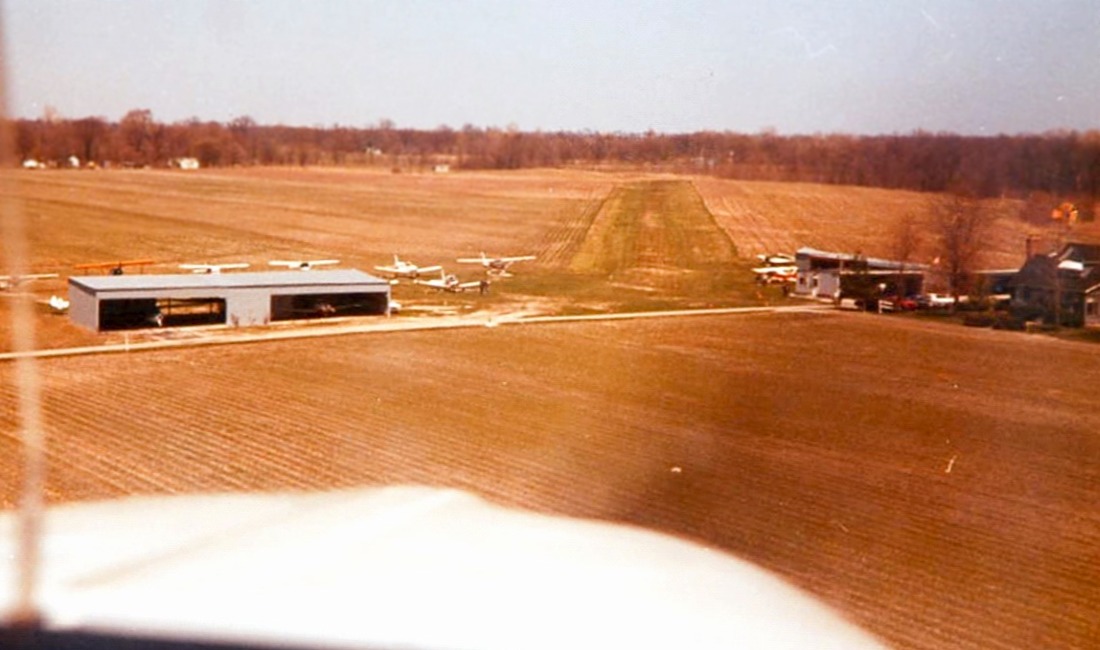
A circa early 1960s photo of a Piper PA-12 Super Cruiser in front of a Flying L Airport hangar (courtesy of Ed Whinnery).
Ed Whinnery continued, “By the end of the 1960s, the Lebert Flying L Airport had 2 hangars without doors.
The wooden framework was coved with galvanized corrugated sheet metal.
The original hangers were placed in an 'L' shape; the east/west hangar had place for 3 aircraft, and the north/south hangar had place for only 1 aircraft.
There was a small pilot lounge at the west end of the east-west hangar.”

A circa 1960s photo by Ed Whinnery of a Funk touching down toward the northeast at Flying L Airport.
Ed Whinnery continued, “It was common in the mid to late 1960s that on Saturdays or Sundays
several aircraft would take off & fly in formation to the Civic Memorial Airport at East Alton where the crews would have coffee & brunch.
I’m sure that the flights continued during the 1980s.
I remember flying to Civic Memorial several times with my dad in the mid & late 1960s.”
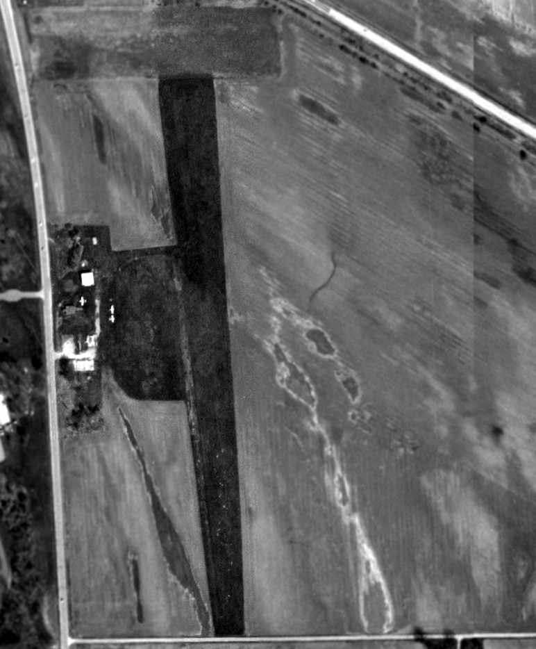
The 1968 USGS topo map still labeled the airport as “Cyril Lebert Airport”,
with with its new runway configuration of a single unpaved northeast/southwest runway, with a few small buildings on the south side.

A 1968 photo of Lew & Jim Whinnery touching up after painting Lew’s Piper Super Cruiser PA-12 at Flying L Airport (courtesy of Ed Whinnery).

A 4/20/69 photo by Tom Lebert of Lew Whinnery with his Piper Super Cruiser at Flying L Airport, with Tom Lebert Jr sitting on the tire (courtesy of Ed Whinnery).

The last aeronautical chart depiction which has been located of Lebert Airport was on the August 1969 Cincinnati Sectional Chart.
It depicted “Leberts” as a private airfield with a 1,900' unpaved runway.
Ed Whinnery continued, “Lew Whinnery was probably the first pilot to land & take off from the Flying L Airport in a twin-engine [plane],
flying a Piper Apache (Model PA-23) during the late 1960s or early 1970s.”

A sad photo by Tom Lebert of Bill Dickerson’s damaged Stearman after being flipped on its back during a 6/19/73 storm with 70 mph winds at Flying L Airport.
Ed Whinnery recalled, “The storm also tore off part of the roof on one of the hangars.”
Ed Whinnery continued, “Runway lights were installed in the early 1970s.
Pilots would click their radio microphones on a designated frequency to turn the lights on & off.
There was an 'Airport' sign on Route 4 for many years directing motorists to the airport,
but this was removed in the mid-1970s at the recommendation of Henry’s insurance agent.”
Ed Whinnery continued, “A sign on the outside wall of the pilots lounge reminded pilots:
RESTRICTED
Left traffic pattern
Alt. 440 ft Use at own risk
No commercial operations
No aerobatics or buzzing
No touch and go
WATCH FOR SCOTT TRAFFIC”
By the mid-1970s the original north/south hangar was expanded to store 2 additional aircraft & a new east/west 3-place hangar was built.
Outside tie-downs were increased for a total of 20 airplanes.”

An April 1975 aerial view by Joe Whinnery looking southeast at Lebert Flying L Airport.
Ed Whinnery observed, “Notice the 'Lebert' & the winged 'L' on the barn roof.”
An April 1975 aerial view by Joe Whinnery looking southwest on final for Lebert Flying L Airport (courtesy of Ed Whinnery).

A beautiful April 1975 photo by Joe Whinnery of the Stearman biplane owned & piloted by Bill Dickerson
coming in for a landing while people in front of the Flying L Airport pilots' lounge watch (courtesy of Ed Whinnery).

An April 1975 photo by Joe Whinnery of a Globe Swift landing at Flying L Airport (courtesy of Ed Whinnery).

An April 1975 aerial view by Joe Whinnery looking east at Flying L Airport (courtesy of Ed Whinnery).
The 1977 USGS topo map labeled it as Flying L Airport.

The last photo which has been located showing aircraft at Lebert Flying L Airport
was an August 1979 photo by Ed Whinnery of the airport dog, Lew Whinnery, Henry Lebert and Joe Whinnery outside the pilot lounge.

An August 1979 photo by Ed Whinnery of the “Home of the Lebanon Air Force” sign on the Lebert Flying L Airport pilot lounge.
According to Ed Whinnery, “Although the airport was expanding & was popular among the pilots during the 1970s & 1980s, there were dark clouds on the horizon.
Nearby MidAmerica Airport (KBLV) was constructed
and increased air traffic at the Lebert Airport was causing friction with Scott Air Force Base as the airport was within the airspace controlled by SAFB.
Also, plans for a proposed Route 50/4 bypass would cut across the northern end of the turf runway, which would force the airport to close in the future.
By 1991, with Henry’s health deteriorating, he decided it was time to close the airport.
The decision to close the airport didn’t come easy for someone who has dedicated most of his life pursuing & realizing his dream.
He sold his farm & airport property in 1998.”

The 1991 USGS topo map depicted the Flying L Airport
as having a single unpaved northeast/southwest runway, with a few small buildings on the south side.
Ed Whinnery reported, “In 1992, Henry Lebert was honoured by Parks Air College as the oldest (age 86) living graduate of his 1929 graduating class.
He was also a member of the OX-5 Club of America, a group of people who flew, rebuilt, or serviced OX-5 engines prior to 1940.
Henry died on 3/26/99, 92 years old.
'OX-5 Pioneer' is inscribed on his headstone in the St. Joseph Cemetery, Lebanon.”

A circa 2010 aerial view looking south at the south side of the site of the Flying L Airport showed a hangar remained (the building on the right),
whereas the building on the left was a post-airfield addition.

A 2014 aerial view shows that one hangar remains on the south side of the site of Flying L Airport,
which is otherwise unrecognizable as a former airport.
All of the older airport buildings on the northwest side, from the original Cyril Lebert Airport have been removed.
Ed Whinnery observed in 2015, “All of the former airport buildings on the field have been removed, with the exception of the east/west 3-place hangar.
The runway has been returned to cultivation. All that remains are many fond memories.”
The site of Lebert Airport is located southeast of the intersection of Southern Drive & Route 4.
Thanks to Ed Whinnery for pointing out this airfield.
____________________________________________________
38.98 North / 89.75 West (Northeast of St. Louis, MO)

A circa 1946 photo of an Aeronca at WLS Airport, with a building under construction (courtesy of Jack Abercrombie).
According to Livingston IL History (courtesy of Jack Abercrombie), “In 1946 a group of 5 men,
Ted Dworzynski, John Bellovich, Elmer France, Arthur Coalson, and John Repovsch, planned to build an airport & flying school.
It was located on John Repovsch’s land a quarter of a mile north of the Route 66 overpass over the Big Four Railroad.
It encompassed 80 acres & was east of Mt. Olive & Staunton Coal Mine #2.
In February 1946, the Illinois Department of Aeronautics approved the plan.
It was named W.L.S. Airport; the initials designating Williamson, Livingston and Staunton, the 3 adjoining communities.
By 6/13/46 four airplanes were available for passenger service.
One was a [surplus] PT-23 Army primary training plane & one a Navy Timion training plane.”
Livingston IL History continued, “One Sunday in October 1946, an air show was held at the airport which included the following:
Formation Flying, Leonard Brown of Staunton former Army pilot, Bombing Practice,
Comic Stunt Flying, Felix Revello of Wilsonville former Army pilot, Ted Soper, well-known stunt pilot,
Parachute Jump by Flash Kelly, known as 'The Greatest'.
Admission fee was 75 cents for adults & 25 cents for children.
Fifty cents of the adult price could be applied to a $2 airplane ride after the show or anytime within 30 days.”
Livingston IL History continued, “On 9/1/47, Labor Day, the W.L.S. had a formal opening.
An afternoon of flying exhibition, stunts, glider flights, parachute jumps & bombing was held with 3 men from Springfield participating –
Jimmy Graham, Arthur Treppler and Norman Bruckner.
A fish fry was held in the afternoon & evening.
In the evening a dance was held in the big hangar with Louis Baldoni & his Vets furnishing the music.”

A 1948 advertisement for WLS Airport (courtesy of Jack Abercrombie) proclaimed that it was “under new management”
and “will be open every day beginning 1/17/48.”

The last depiction which has been located of WLS Airport was on the 1954 USGS topo map,
which depicted a single north/south runway to the east of Williamson, labeled simply as “Airfield”.
WLS Airport was evidently closed by 1958,
as it was no longer depicted on the 1958 USGS topo map.
By the time of a 1991 USGS aerial photo, there was no recognizable trace at the site of WLS Airport,
with the property having reverted to a farm field.

A 2012 aerial view showed no trace remaining of WLS Airport.
The site of WLS Airport is located east of the terminus of 3rd Street.
Thanks to Jack Abercrombie for pointing out this airfield.
____________________________________________________
Lakeview Airport / Lakeside Airport / Nichols Airport, Granite City, IL
38.7, -90.07 (East of St. Louis, MO)

Chuck Midyett recalled of Lakeside Airport, “Mom & Dad opened the doors on 7/15/40.”
According to the Greater St. Louis Air & Space Museum (courtesy of Jack Abercrombie),
"In 1940, Chub & Bill Hart moved their flying school to Lakeside Airport when Parks Air College expanded its pilot training to Curtiss-Steinberg Airport.”
However Lakeside Airport was not yet depicted at all on the January 1941 Kansas City Sectional Chart (according to Chris Kennedy).
The earliest depiction which has been located of Lakeside Airport
was a a 1941 aerial view (from the Illinois Natural Resources Geospatial Data Clearinghouse, courtesy of Chris Kennedy).
It depicted Lakeside as having 2 grass runways,
with several small hangars & 10 light aircraft on the west side of the field.

A circa 1940s photo of Chub Wheeler's Fairchild 24, likely taken at Lakeside Airport (courtesy of Jack Abercrombie).

The earliest aeronautical chart depiction which has been located of Lakeside Airport
was on the October 1942 Kansas City Sectional Chart (courtesy of Chris Kennedy).
It depicted Lakeside as a commercial/municipal airport.

A 9/26/43 aerial view looking west from the 1945 AAF Airfield Directory (courtesy of Scott Murdock)
depicted Lakeside Airport as having 3 runways, with several hangars along the west side.
The 1945 AAF Airfield Directory (courtesy of Scott Murdock) described Lakeside Airport
as a 154 acre square-shaped field having 3 sod runways, the longest being the 2,500' north/south strip.
Lakeside was said to have 3 metal hangars, the largest measuring 100' x 60'.
The field was described as being owned & operated by private interests.
The 9/27/05 issue of the St. Louis Post-Dispatch had an article
entitled “Lakeside Airport has plows instead of planes on its runway” by Rick Pierce.
It said that when Omar Midyett operated the airport following World War II,
as many as 100 aircraft were based there,
according to a study conducted by Crawford, Murphy & Tilly Consulting Engineers.

Lakeside Airport, as depicted on a 1952 road map (courtesy of Kevin Walsh).
Pamela Hines recalled, “Lakeview Airport...When I was a child my great uncle William Brown owned it.
I have photographs of them standing in front of the facility with 'Brown Aviation' in bold letters.
I was born in 1958 & our family went there when I was a child.”

An undated aerial photo of Lakeside Airport from the 1962 IL Airport Directory (courtesy of Jonathan Westerling).
Lakeside Airport had evidently gained a paved runway at some point between 1941-62,
as the directory depicted the field as having 3 turf runways,
including a 2,600' turf north/south runway within which was inset a 1,700' bituminous strip.
A total of almost 50 light aircraft were visible parked on the west side of the field.
The operator & manager was listed as Omar Midyett.
The airport was listed as “Lakeview Airport” in the 1966 IL Airport Directory (courtesy of Chris Kennedy).
The 1966 directory had the same photo of the field as had been used in the 1962 directory.
The operator was listed as J & S Flying Service,
and the managers were listed as William Jennings & Ed Shafer.
Chris Greer remembered the old Lakeside Airport when the Blue Angels performed there,
when he & his father landed a twin-engine Douglas DC-3 on one of the 3 runways
and when dozens of aircraft were based there.
Chuck Midyett recalled of Lakeside Airport, “We operated until July of 1966.”
Lakeside Airport was not yet depicted on the 1968 USGS topo map.
The airport was renamed Nichols Airport after being purchased by Bill Nichols.

The 1974 USGS topo map depicted “Nickols Landing Field” as having 2 unpaved runways & a few small buildings on the west side.

The 1985 USGS topo map depicted the “Nickols Landing Field” as having 2 runways: north/south & northwest/southeast.
Bill Nichol's heirs eventually sold the property to the Madison County Transit District.
An article entitled “Madison Transit Agency to Buy Nichols Airport” by Lee Conrad
in the 10/9/95 issue of the St. Louis Business Journal said:
“The Madison County Transit Authority plans to spend $455,000 later this month
to buy Nichols Airport in an unincorporated area between Granite City & Collinsville on the east side of Horseshoe Lake.
The 150-acre airport, formerly known as Lakeside Airport, has only about 6 planes,
a grass runway & dilapidated hangars, said Jerry Kane, managing director of the transit district.
The East-West Gateway Coordinating Council, a regional planning agency,
recommended the acquisition to make Nichols a public airport as part of its master aviation plan.
The Airport Improvement Fund, a federal funding source, can be used for publicly owned airports only, Kane said.
The district plans to improve the facility with a hardtop runway & new hangars, he said.
The airport's proximity to Downtown St. Louis
and the fact that it has clear approaches from all directions led East-West Gateway to its conclusion that the airport
could become a big part of the area's aviation system by handling future demand if it became a publicly owned airport.
It also will help the entire region with development, said local officials.
'The acquisition of Nichols Airport is essential to Madison County's future development,' said County Chairman Nelson Hagnauer.
Granite City Mayor Ron Selph said as development on the Missouri side of the area
extends farther west & away from downtown St. Louis,
the Metro East will become more attractive to developers, he said.
'Maybe they'll start looking east & develop on this side of the river”, he said.”
However, by the time the county bought the site, activity at the airport had already declined.
A November 1995 photo showed just 4 aircraft at the facility & a few buildings.
Jerry Kane, the head of Madison County Transit, which owns the site,
says the push for the airport came from former Madison County Board Chairman Nelson Hagnauer,
who at the time was also the head of the transit district.
However, Morris Chapman, a longtime attorney in Granite City who kept his plane for years at the old Lakeside Airport,
says the death of Hagnauer in 1996 doomed the project.
"Hagnauer was contemplating making a real airport out of it," Chapman said.
"Then he died, and the county lost interest in it."
Two factors grounded the project, according to Jerry Kane.
One was the need to obtain additional property - in addition to the 150-acre airport site - to make longer runways.
The second was a cutback in federal funding for such projects.
In the 1998 USGS aerial photo, a total of only 3 light aircraft were still visible on the field.
Jerry Kane said the transit district tried to sell the airport in about 2000.
However, the buyer could not obtain the necessary financing & the deal collapsed, he said.

Unfortunately the 2003 USGS aerial photo showed that the airfield had been closed at some point between 1998-2003,
with all of the former airport buildings on the west side of the field having been removed as well.
According to the article in the 9/27/05 issue of the St. Louis Post-Dispatch,
“Today, all that remains is a lone grass runway & patches of pavement punched through with weeds.
Chris Greer says his father has tried for years to revive interest in the facility
and even had fliers and signs printed up that read 'Save Lakeside Airport'.
Meanwhile, the transit district continues to hold on to the property.
Kane said the land continues to appreciate in value -
and will be worth more to the transit district than if the money spent on the land had been invested.
A man farms the property and, in return, keeps the front of the property & the old runway mowed.
Dan Corbett, a longtime member of the transit district's governing board,
says the board has no plan to turn the site back into an airport or to sell it in the immediate future.”

A circa 2007 aerial view looking north, showing a car parked over the foundation of the former hangar at the site of Lakeside Airport.
The site of Lakeside Airport is located southeast of the intersection of Horseshoe Lake Road & Route 111.
Thanks to Chris Kennedy for pointing out this airfield.
____________________________________________________
(Original) Springfield Municipal Airport / Southwest Airport, Springfield, IL
39.75, -89.69 (Southwest of Chicago, IL)

An 11/11/31 photo of the 1st blimp to land at Springfield's Commercial Airport (from the IL Digital Archive).
Springfield's original municipal airport was located on the southwest side of the town.
The date of construction of the original Springfield Municipal Airport has not been determined.
The earliest reference to the field which has been located
was an 11/11/31 photo of the 1st blimp (type unidentified) to land at Springfield's Commercial Airport (from the IL Digital Archive).
The photo depicted a grass airfield, with a hangar & several other buildings in the background.
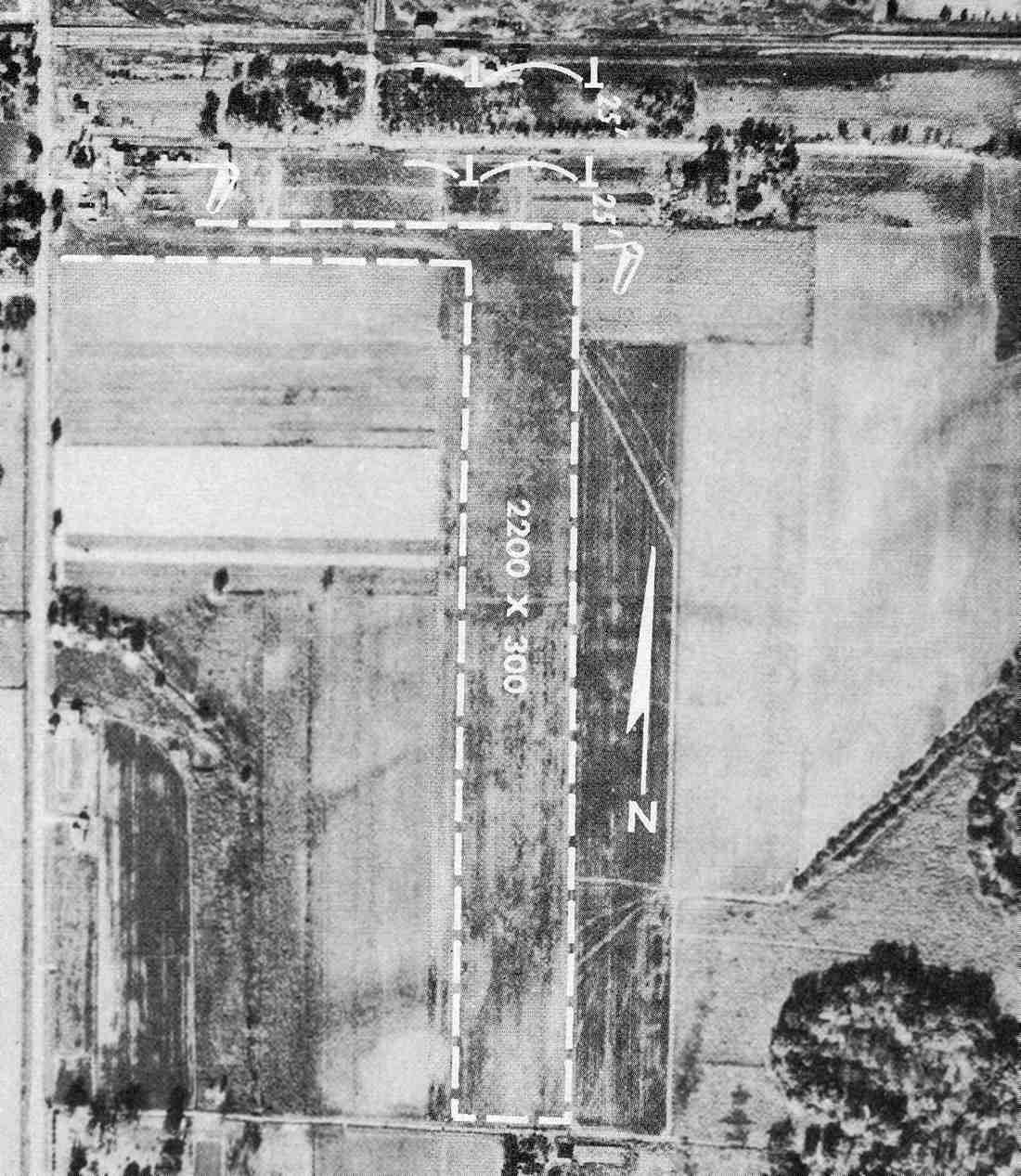
The Airport Directory Company's 1933 Airport Directory (courtesy of Chris Kennedy)
described Springfield as a commercial airport, located 3.5 miles southwest of the town.
The field was said to consist of a rectangular 2,500' x 2,600' sod landing area.

A 1934 aerial view looking southwest (from the IL Digital Archive, courtesy of Mark Hess)
depicted Southwest Airport as having 2 runways in an X-shape,
with a ramp with several buildings on the east side of the field.

A 1939 aerial photo (from the Access IL Historical Aerial Photography collection, via Chris Kennedy)
depicted the the original Springfield Municipal Airport as having 2 runways in an X-shape,
with a ramp with several buildings on the east side of the field.
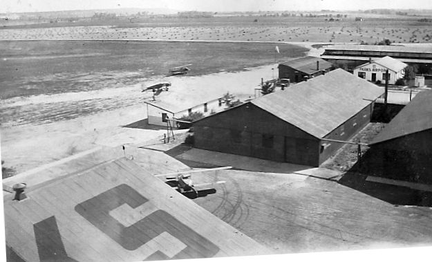
A 9/15/40 photo of the a Taylorcraft & an Ercoupe in front of a Springfield Aviation Company hangar (from the IL Digital Archive).

An undated aerial view looking northeast at the original Springfield Municipal Airport,
from The Airport Directory Company's 1941 Airport Directory (courtesy of Chris Kennedy).
The airport had been improved somewhat with shale runways,
as the directory described Springfield Municipal as having two shale runways: 3,080' northwest/southeast & 2,850' northeast/southwest.
Two other unpaved runways were also visible in the aerial photo,
and several hangars were depicted on the east side of the field.

Springfield Airport was depicted as a commercial or municipal airport
on the April 1943 Cincinnati Sectional Chart (courtesy of Chris Kennedy).

A circa 1942-45 aerial view looking north from the 1945 AAF Airfield Directory (courtesy of Scott Murdock)
depicted Springfield Airport as having 2 runways, with several hangars along the east side.
The 1945 AAF Airfield Directory (courtesy of Scott Murdock) described Springfield Airport
as a 159 acre irregularly-shaped field having a total of 5 shale or sod runways, the longest being the 3,080' east/west sod strip.
Springfield was said to have 5 steel hangars, the largest measuring 80' square.
The field was described as being owned & operated by private interests.
The 1945 Haire Publishing Company Airport Directory (according to Chris Kennedy)
said the field was owned & operated by the Springfield Aviation Company,
and the airport managers were Graig (sic) Isbell & Gelder Lockwood.
It was still labeled "Springfield" on the October 1946 Cincinnati Sectional Chart (according to Chris Kennedy).
However, the airport was apparently renamed "Southwest" at some point in the next two years,
as that is how it was labeled on the September 1948 Cincinnati Sectional Chart (courtesy of Chris Kennedy).
The airport's name was probably changed to differentiate it from the larger former military airport to the north of Springfield,
which had become available for civilian use.
Southwest Airport was depicted as having a 3,000' unpaved runway.

The 1950 USGS topo map depicted Southwest Municipal Airport as having 2 paved runways & several buildings on the east side.

The 1954 IL Airport Directory (courtesy of Lee Corbin)
depicted Southwest Airport as having two 2,430' runways, and a set of buildings on the east side.
The 1956 IL Airport Directory (courtesy of Chris Kennedy)
depicted Southwest Airport as having two 2,430' turf runways, oriented northwest/southeast & northeast/southwest.
Several hangars were depicted on a ramp on the east side of the field,
along with several light aircraft parked on the ramp.
The operator was listed as listed as Springfield Aircraft Sales & Service,
and the manager was listed as John Brandis.
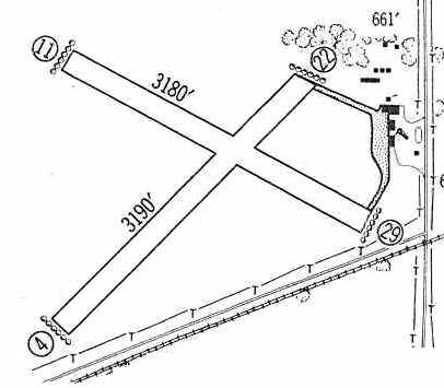
The 1960 Jeppesen Airway Manual (courtesy of Chris Kennedy)
depicted Southwest Airport as having a 3,190' turf Runway 4/22 & a 3,180' turf Runway 11/29.
Several hangars were depicted along the ramp on the east side of the field.

The December 1961 Cincinnati Sectional Chart (courtesy of Chris Kennedy)
depicted Southwest Airport as having a 3,000' unpaved runway.

The last photo which has been located of Southwest Airport was an undated aerial view in the 1962 IL Airport Directory (courtesy of Jonathan Westerling).
It depicted Southwest Airport as having two 2,470' turf & shale runways, oriented northwest/southeast & northeast/southwest.
Several hangars were depicted on a ramp on the east side of the field,
along with 8 light aircraft parked on the ramp.
The operator was listed as listed as Springfield Aviation Company,
and the manager was listed as Gelder Lockwood.
Southwest Airport was evidently closed (for reasons unknown) at some point between 1962-64,
as it was no longer depicted at all on the February 1964 Cincinnati Sectional Chart (according to Chris Kennedy).
Springfield Airport was still depicted on the 1969 USGS topo map,
even though it had not been operational already for several years at that point.
Although a 1998 USGS aerial photo showed that the majority of the former airport property had been covered by housing,
surprisingly some of the former airport buildings remained standing on the east side of the site,
including one large hangar that was visible on both the 1941 & 1956 aerial photos.

A circa 2007 aerial view looking east at the 60-year old hangar & other airport buildings remaining on the east side of the site of Springfield Airport.

A circa 2007 photo looking west at the 60-year old hangar & another airport building remaining on the east side of the site of Springfield Airport.

A 5/15/12 aerial photo shows that the former Springfield hangar remained standing on the east side of the property.
The site of Southwest Airport is located southwest of the intersection of Chatham Road & Westchester Boulevard.
____________________________________________________
Parks College Airport (H72), East St. Louis, IL
38.57, -90.18 (East of St. Louis, MO)

An advertisement for Parks Air College from the 8/25/28 issue of Aviation Magazine (courtesy of Chris Kennedy).
Parks College was founded by Oliver L. Parks in 1927, just two months after Charles Lindbergh's historic flight,
and was the first certified aviation school in the US.
Mr. Parks believed, prophetically, that aviation had a great future
& very early he saw the need for instruction in aircraft design, maintenance & flight safety.
The fledgling College was determined to raise the standards of aviation education.
In pursuing this end, Parks College became the first federally approved school of aeronautics
& today still holds FAA Certificate #1.
In the late 1920's Mr. Parks operated an aircraft factory in conjunction with the school,
where Parks' P-1s, P-2s & P-3s were built.

A 1929 aerial view looking southeast at the Parks Airport, taken during the Gardner Cup Races.
The airplanes lined up on the right flew in a round trip race to Indianapolis.
The race was won by "Speed" Holman in a Whirlwind-Laird.
Photo is courtesy of Shaun Braley.

Students in front of the Parks Air College Administration building, circa 1920s.
During those early years, the College was an official stop in the famous coast-to-coast air races.
Among the aviation greats who visited the campus were Charles Lindbergh, Amelia Earhart,
Howard Hughes, Jimmy Doolittle, and Eddie Rickenbacker.

The earliest aeronautical chart depiction which has been located of Parks Airport was on the November 1933 Cincinnati Sectional Chart.

An undated (circa 1930s?) photo of a row of biplanes & a Piper Cub inside a Parks Air College hangar (courtesy of Joel Russell).
An undated (circa 1930s?) photo of several planes in front of the Parks Air College hangars (courtesy of Joel Russell).
In 1939 Parks was one of the air schools contracted by the Army Air Corps to give elementary flight training to cadets.

A 1940 aerial photo of the Parks College Airfield (from the Access Illinois Historical Aerial Photography collection, via Chris Kennedy).
The airfield had 2 runways within a large grass airfield area.
There were a dozen aircraft visible on the field, including 2 which appear to be getting ready for takeoff (at the north end).

A Fall 1940 photo of a Army Northrop A-17A in front of a Parks Air College hangar during a visit (from the Parks Air College collection via Terry Love).

An aerial view looking southeast at Parks from the Airport Directory Company's 1941 Airport Directory (courtesy of Chris Kennedy).
The field was described as a 2,600' x 1,700' sod rectangular landing area,
with two cinder runways measuring 2,200' & 1,150'.
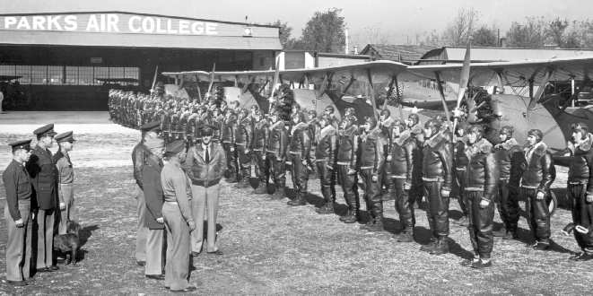
Army Air Corps Cadets in front of biplane trainers at the Parks Air College, circa 1940s.
During the WW2 era, Parks College & its subsidiaries were responsible
for training 1 out of every 10 Army Air Corps pilots, plus thousands of aircraft mechanics.
Calvin Casteel recalled, “During WW2 I attended Parks Air College
for my Army Air Corps primary flight training in the PT-19 Fairchild trainer.
Our barracks & ground school classes were at Parks Air College
and our flight training was at Curtiss Steinberg Air Field just up the road a short piece.”

A 9/26/43 aerial view looking northeast from the 1945 AAF Airfield Directory (courtesy of Scott Murdock)
depicted Parks Airport as having 2 runways, with several hangars along the northwest side.

A 1943 photo by Ed Powers of a Curtiss AT-9A, 42-56891, seen in front of the Parks hangars.

A 1943-44 photo by Ed Powers of perhaps the largest aircraft ever to fly in & out of the Parks Airfield –
a Boeing B-17F bomber, 41-24436, seen in front of the Parks hangars.
Parks was described in the 1944 US Army/Navy Directory of Airfields (courtesy of Ken Mercer)
as having a 2,600' runway.
The 1945 AAF Airfield Directory (courtesy of Scott Murdock) described Parks Airport
as a 115 acre rectangular field having 2 cinder runways, measuring 2,600' north/south & 2,300' east/west.
Parks was said to have 3 brick or metal hangars, the largest measuring 340' x 100'.
The field was described as being owned & operated by private interests.
Parks College became part of Saint Louis University in 1946.

The 1949 USGS topo map depicted Parks Airport as a diamond-shaped field with buildings along the northwest side, labeled simply as “Airport”.

Parks College Airport, as depicted on a 1952 road map (courtesy of Kevin Walsh).
Hans Friedebach recalled, “I went to schools at Parks in 1957 & lived in the Portview Arms dormitory.
While attending Parks I worked part-time for Walston Aviation
at Parks Metropolitan Airport [located just to the east of Parks College Airport].
I owned a Fairchild PT-26 which I kept at Parks Metropolitan.
Father Choppesky, Parks College Dean, was surprised one day to see me land at the College
to fetch my sandwich lunch at the Cafeteria before hopping into the PT-26 to fly back over to my part-time job.”
The 1958 IL Airport Directory (courtesy of George Miner) depicted Park's College Airport
as having 2 "cinders" runways: a 2,500' north/south strip & a 2,400' east/west strip.
The manager was listed as the Rev. J.C. Choppesky, Regent & Acting Dean.
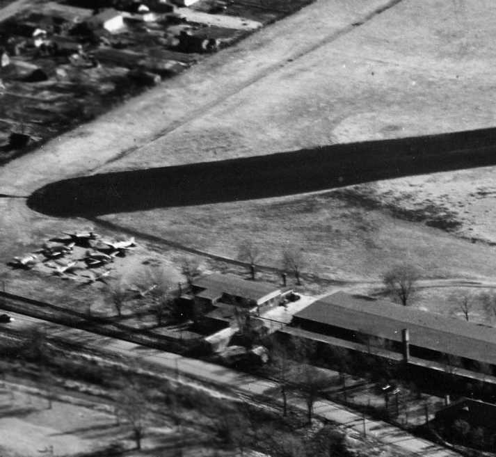
A closeup from a 1960 aerial view looking east at a group of aircraft parked on the north end of the Parks College Airfield (courtesy of Robin Sova).

An undated aerial photo of Parks College Airport from the 1962 IL Airport Directory (courtesy of Jonathan Westerling).
It depicted the field as having 2 "cinders" runways: a 2,500' north/south strip & a 2,400' east/west strip.
The manager was listed as the Rev. J.C. Choppesky, Regent & Acting Dean.
Dean Sanborn recalled, “I attended Parks 1964-66. There were no flight lessons or operations of that sort after 1964.
We went to Collinsville Airport to learn to fly.”

A 3/3/68 USGS aerial photo shows Parks College Airport after routine flight operations had ended,
with the airfield facilities still completely intact, but devoid of aircraft.
The last photo which has been located of an aircraft at the Parks Airfield was a 1970 photo of a Fairchild PT-26
which was permitted to fly into the airfield at Parks College for an open house,
after the field had been closed to most flight operations.
John Schumacher recalled, “I was a student at Parks from August 1979 to July 1982.
The airport, commonly referred to as the 'Beanfield' was maintained, but use was by permission only.
During my time there in the spring there would be a fly-in, where alumni & others could land at the campus.
There was barbeque, campus tours, displays, and aerobatic demos by Ed Merchant in his Pitts S-1, an alum from around the 1976-77 time frame & others.
Other times it was used by students for radio-controlled model airplane flying.”
The Parks College Airport was still listed as a private airfield
in the 1982 AOPA Airport Directory (courtesy of Ed Drury),
which described the field as consisting of a single 1,670' turf Runway 18/36.
John McGowan reported that he attended Parks Air College in 1993.
"I have a picture somewhere of an Air Force C-9 [a military version of the DC-9]
doing a slow pass along the runway that was left after they built the dorms.
It was during an open house, where many Parks alumni had flown in to display their airplanes.
I'm pretty sure that the pilots of the C-9 were former Parks students,
and from what I was told, they were definitely exceeding some safety limitations whey they did their fly-by."
Parks alumnus H.G. Frautschy recalled that in approximately 1995, “I flew in with Capt. Dick Hill,
flying his Cessna Bamboo bomber into the field for a Parks College Open House.
That northwest corner of the airport did look pretty close, but the Cessna’s low wing loading made it easy.
We had to drop it in over the wires along the railroad tracks on the east side of the field.
We had a a great visit, and I was blessed with 4 hours of twin-engine cross country time. Getting out was a little more interesting.”
John Schumacher recalled, “The Cahokia campus of Parks, and the 'Beanfield' [airfield], closed at the end of the 1996 academic year,
which coincided with the opening of the new Parks facility on the main campus of St Louis University.
This was bittersweet to most of the alumni as the campus was old, but very rich in aviation history & tradition.
For the time the university owned it, they paid for private security on the grounds.
When the city of Cahokia bought the property this was not continued, and the campus has been the victim of some serious vandalism.
A sad state of affairs for a facility conceived & executed by Oliver Parks & Charles Lindbergh, and responsible for a large supply of pilots during WWII.”

The 1999 USGS aerial photo showed the north/south paved runway at the Parks College Airfield remained completely intact,
although several classroom buildings had been built over the western edge of the field.

A circa 2006 aerial view looking north at a former hangar which remains on the western corner of the Parks College Airfield site.
This same hangar was visible in the 1929 aerial photo.

An 8/6/12 aerial photo showed that Parks' north/south paved runway was increasingly deteriorated.
Recent photos show the historic Parks College airfield buildings to be abandoned & in a further state of deterioration – quite sad.
Parks alumnus H.G. Frautschy reported in 2014, “The campus is now closed & completely abandoned.”
____________________________________________________
Since this site was first put on the web in 1999, its popularity has grown tremendously.
That has caused it to often exceed bandwidth limitations
set by the company which I pay to host it on the web.
If the total quantity of material on this site is to continue to grow,
it will require ever-increasing funding to pay its expenses.
Therefore, I request financial contributions from site visitors,
to help defray the increasing costs of the site
and ensure that it continues to be available & to grow.
What would you pay for a good aviation magazine, or a good aviation book?
Please consider a donation of an equivalent amount, at the least.
This site is not supported by commercial advertising –
it is purely supported by donations.
If you enjoy the site, and would like to make a financial contribution,
you
may use a credit card via
![]() ,
using one of 2 methods:
,
using one of 2 methods:
To make a one-time donation of an amount of your choice:
Or you can sign up for a $10 monthly subscription to help support the site on an ongoing basis:
Or if you prefer to contact me directly concerning a contribution (for a mailing address to send a check),
please contact me at: paulandterryfreeman@gmail.com
If you enjoy this web site, please support it with a financial contribution.
please contact me at: paulandterryfreeman@gmail.com
If you enjoy this web site, please support it with a financial contribution.
____________________________________________________
This site covers airfields in all 50 states.