
Abandoned & Little-Known Airfields:
Texas - Waco area
© 2002, © 2016 by Paul Freeman. Revised 10/14/16.
This site covers airfields in all 50 states: Click here for the site's main menu.
____________________________________________________
Please consider a financial contribution to support the continued growth & operation of this site.
Belton Airport (revised 11/26/14) - Bryan AAF / Bryan AFB / TX A&M Flight Test Station Airport (added 1/25/15)
(Original) Hillsboro Municipal Airport (revised 10/14/16) - Waco Aux AAF #5 / Prairie Hill AF Aux (revised 6/16/13)
____________________________________________________
Bryan Army Airfield / Bryan Air Force Base / Texas A&M Flight Test Station Airport (83TX), Bryan, TX
30.634, -96.48 (Southwest of Waco, TX)
A 10/16/43 aerial view looking north at Bryan AAF from the 1945 AAF Airfield Directory (courtesy of Scott Murdock).
According to Wikipedia, Bryan Army Airfield was established in 1942 as part of the expansion of the flying training program by Army Air Forces Training command.
It was activated on 3/1/42 under the Central Flying Training Command (CFTC) 77th Flying Training Wing (Advanced, Single Engine), Foster Army Airfield, TX.
Bryan Army Airfield was constructed with 3 concrete runways, one main 5,500' north/south & 2 secondary 5,000' northeast/southwest & northwest/southeast.
A large parking apron was built with additional taxiways, landing aids & several hangars.
Buildings were ultimately utilitarian & quickly assembled.
Most base buildings, not meant for long-term use, were constructed of temporary or semi-permanent materials.
Although some hangars had steel frames & the occasional brick or tile brick building could be seen,
most support buildings sat on concrete foundations but were of frame construction clad in little more than plywood & tarpaper.
The base had its own hospital, 40-acre sewage plant, 9 administration buildings, 4 mess halls, supply rooms, officers' quarters, a guardhouse, a chapel, and 37 barracks.
Bryan AAF had 4 auxiliary fields which were constructed in the area:
Somerville Field (AAF Aux #1), Hearne Field (AAF Aux #2, later reused as Hearne Municipal Airport),
AAF Aux #3 (location unknown), and Easterwood Field (AAF #4).
Bryan AAF became the home of the Army Air Forces Instructors School (Instrument Pilot),
which was established as a means of strengthening the AAF instrument program.
A substantial improvement in the instrument proficiency of basic graduates was achieved;
this resulted from standardized employment of the more efficient system, proper training of instructors,
procurement of adequate equipment, and allocation of more flying hours to instrument work.
In 1943, Bryan Field was the starting point of the first intentional meteorological flight into a hurricane.
The earliest depiction which has been located of Bryan AAF was a 10/16/43 aerial view looking north from the 1945 AAF Airfield Directory (courtesy of Scott Murdock).
It depicted Bryan as having 3 concrete runways, with a large concrete ramp & numerous buildings on the east side.
Bryan AAF was assigned to the AAFTC Central Flying Training Command as an AAF Pilot School (Advanced, Twin-Engine).
The 1945 AAF Airfield Directory (courtesy of Scott Murdock) described Bruan AAF as a 1,946 acre irregularly-shaped property having 3 concrete 5,000' runways.
The field was said to have 2 wooden 122' x 80' hangars,
and to have 2 auxiliary fields: #1 Somerville Field & #2 Hearne Field.
Bryan AAF was said to be owned by the U.S. Government, operated by the Army Air Forces, but to be inactive.
Instructor training continued at Bryan AAF until the base was inactivated in February 1947.
Following World War II, enrollment at nearby Texas A&M University soared.
Housing was in short supply, so between September 1946 & May 1950 an estimated 5,500 men were housed & attended classes at an annex on the former Bryan Army Airfield.
The Air Force retained a recapture right of the Bryan property, which it exercised to accommodate the Korean War training surge.
In the spring of 1951 the government purchased 1,376 acres at the site,
and Bryan Field was reactivated as Bryan Air Force Base under Air Training Command (ATC).
Much construction was necessary to bring the World War II training base up to postwar Air Force standards.
In 1951 additional land surrounding the base was appropriated for military facilities & extended runways.
A jet runway (18/36) was laid down along with accompanying taxiways, concrete block buildings & other support facilities
to replace the temporary wooden World War II structures that were viewed as substandard for a permanent Air Force base.
The 3530th Pilot Training Wing (Advanced Single-Engine) was activated by ATC on 10/14/51.
The primary mission of Bryan AFB was to provide advanced single-engine pilot training for student officers & aviation cadets of the USAF & foreign nationals.
The 3530th PTW qualified aviation cadets as officers in the USAF.
The 3531st Pilot Training Squadron flew T-28 Trojan single-engine trainers; the 3530th PTS flew F-80 & T-33 Shooting Star jet aircraft.
Gus Grissom, later one of the first astronauts, was a jet instructor at Bryan AFB in the 1950s.

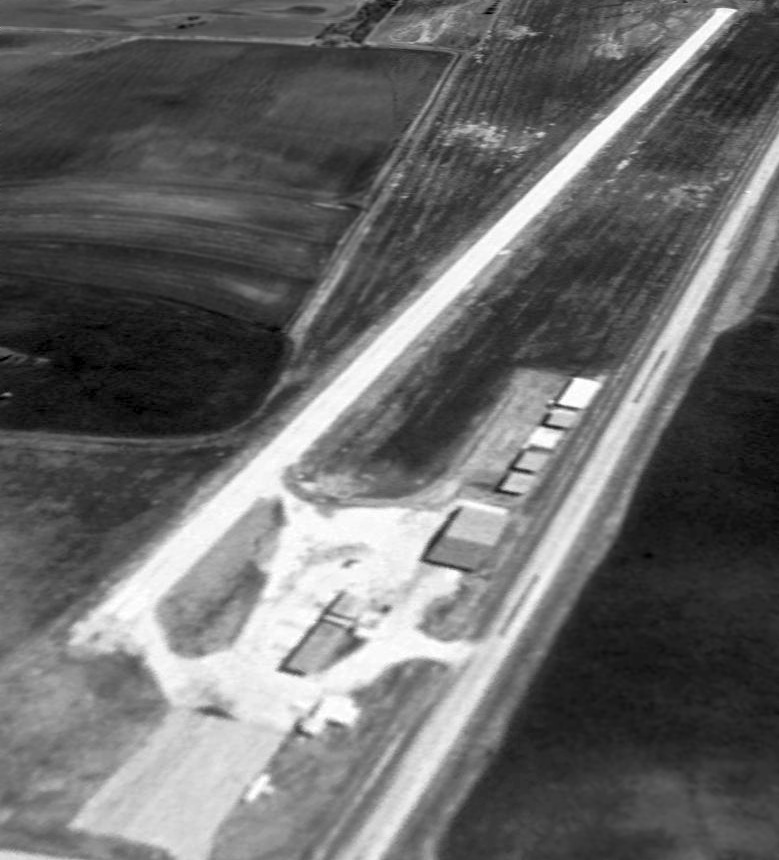
A 1/25/53 USGS aerial view depicted a large number of aircraft on the Bryan AFB ramp.
Also note the considerably longer 4th runway added for jet operations, compared to the 1943 photo.
In 1954 the 3530th PTW began transitioning to all-jet basic training using the T-33/F-80s & retired the propeller-driven T-28s.

A 1954-55 photo of a Lockheed T-33A Shooting Star jet trainer in front of the Bryan AFB control tower.
The last Bryan T-28 was sent to storage in early 1956.

A 1956 photo of an instructor & student of the 3530th PTS discussing last-minute details with the crew chief before departing from Bryan AFB on a training flight.
In 1956 ATC transferred tanker & bomber training to Strategic Air Command & fighter training to Tactical Air Command.
Thus, ATC found itself with a much smaller advanced flying training program.
Jet qualification training had been taught at Craig AFB, AL, but by moving it to Randolph AFB, ATC was able to free Craig for basic pilot training & closed Bryan AFB.
Basic single-engine training ended at Bryan on 6/12/58.
The command discontinued Bryan's 3530th Pilot Training Wing on 10/25/58
and placed the base on inactive status until it transferred to Air Materiel Command on 4/1/60 for subsequent disposition.

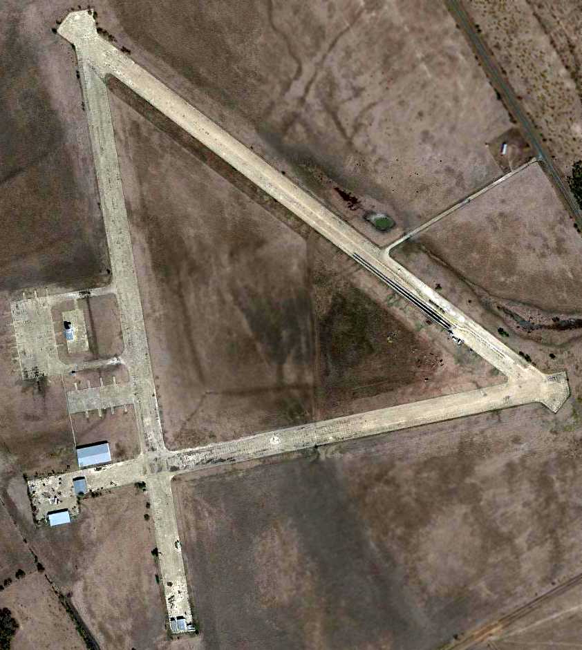
A 3/9/60 USGS aerial view depicted a dramatic difference at Bryan AFB, with the massive facility completely abandoned.
Note the 5th runway which had been added at some point between 1953-60, only a few years before the base's closure.
The abandoned Bryan AFB property was turned over to Texas A&M in May 1961.
The land & buildings were deeded to the Agricultural & Mechanical College of Texas in 1962,
eventually becoming the Texas A&M Riverside Campus.

The 1962 USGS topo map labeled the massive airfield as the Texas A&M University Research Annex.
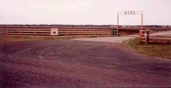
Since October 1966, the runways have been reused as a private airfield, the Texas A&M Flight Test Station airport.
The Bryan runways have also been reused as an SCCA racetrack.
In 2005 the Texas Engineering Extension Service converted a World War II-era hangar at the Texas A&M Riverside Campus
into a training facility for electric power & telecommunications workers.
The hangar was gutted & modernized, with the installation of smart boards, audio-visual aids, and heating & air conditioning.
In 2006, the Texas A&M College of Architecture completed an 8,000-square-foot Built Environment Teaching & Research Facility also known as Architecture Ranch.
The building contains a woodshop, a metal shop, and 2 digital fabrication machines: a CNC Mill & a CNC Plasma Cutter.
Architecture Ranch is located on 12 acres of the Texas A&M Riverside Campus.
A joint Texas A&M / University of TX low-circulation library will begin construction in June 2012 at Bryan.
The facility is designed to hold one million books & eliminate redundancy in the collections of the 2 university systems.

A 2014 aerial view looking northwest at the massive former Bryan AFB.
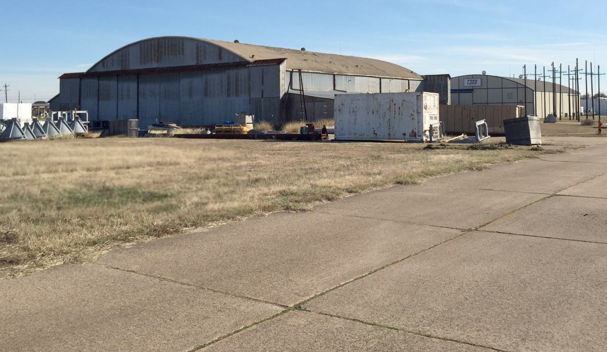
A 1/5/15 photo by Lee Denham of a former Bryan AAF hangar.

A 1/5/15 photo by Lee Denham of a former Bryan AAF hangar.

A 1/5/15 photo by Lee Denham of the former Bryan AAF control tower.

A 1/5/15 photo by Lee Denham of sign which remains inside a former Bryan AAF hangar, saying “The pilot depends on you.”

A 1/5/15 photo by Lee Denham of tattered windsock next to a former Bryan AAF runway.
Kenneth VeArd reported in 2015, Lee Denham “is currently the only pilot authorized to fly in & out of [83TX, TX A&M Flight Test Station Airport].
He is a Pilot for the Texas A&M research department.”
Lee reported he flies an “Air Tractor 402B, Cessna Aghusky T188, Cessna T206, MD600N helicopter, all based at 83TX.”
The site of Bryan AAF is located southwest of the intersection of Route 21 & Route 47.
____________________________________________________
31.045, -97.483 (Southwest of Waco, TX)

A September 1954 photo (courtesy of George Wilhite) “of an unidentified person, me [George Wilhite], and Billy Ford Palmer,
who took me for a flight in Cub NC98155” at Belton Airport.
This general aviation airport was evidently established at some point between 1945-54,
as it was not yet listed among active airfelds in the 1945 AAF Airfield Directory (courtesy of Scott Murdock).
George Wilhite recalled, “In the early 1950s my Dad was a farmer/rancher & we lived in the country near Belton.
I had already developed an interest in aviation & ultimately persuaded my Dad to drop me off at the Belton Airport
on Highway 190 southwest of town on Saturdays when we went to town to grocery/supply shop.
To the best of my knowledge my first visit was sometime in 1954 at age 11.
I would sweep the office, clean the hangar, planes, etc. to try to somehow earn a 10-20 minute Cub ride.”
George continued, “The owner/operator of the airport was Mr. J.A. 'Pete' Reed.
I don’t know when he first opened the airport, but a cousin (5 years older than me) says he worked there in summers about 3 years (early 1950s)
and flew 20 or more hours of dual instruction in Cubs.
My cousin says that Mr. Reed started a flight/ground school to take advantage of VA flight training monies awarded to veterans.
I guess that money dried up and he restored Cubs, sold fuel, rented hangars & planes.
I first flew with his instructor, Billy Ford Palmer, in 1954.”
The earliest depiction of Belton Airport which has been located was a September 1954 photo (courtesy of George Wilhite)
“of an unidentified person, me [George Wilhite], and Billy Ford Palmer,
who took me for a flight in Cub NC98155” at Belton Airport.

A September 1957 photo of 3 Piper Cubs inside Betlon's hailshed hangar (courtesy of George Wilhite).
George Wilhite recalled, “In 1959 I stopped going to the airport due to school & track competition during my high school years.”

A 12/12/64 USGS aerial photo showed Belton to have a single unpaved north/south runway, with several small buildings on the north side.
No aircraft were visible on the field.

The earliest aeronautical chart depiction which has been located of Belton Airport
was on the November 1965 Austin Sectional Chart (courtesy of George Wilhite).
It depicted Belton as having a 2,100' unpaved runway.
The 1966 Austin Sectional Chart (courtesy of John Price)
continued to depict Belton as having a 2,100' unpaved runway.

The 1966 TX Airport Directory (courtesy of George Wilhite) depicted Belton Airport
as having a 2,100' turf Runway 17/35, with 2 taxiways leading to a few small buildings on the northeast side.
However, George Wilhite observed, “I don’t exactly agree with the layout of buildings as depicted. The hail shed is not even shown.”

The last photo which has been located showing Belton Airport in operation was a photo by George Wilhite
“of Taylorcraft BC12D N95598 at the Belton Airport in June or July 1966.”

The earliest topo map depiction which has been located of Belton Airport was on the 1966 USGS topo map.
It depicted “Belton Airfield” as having a single north/south unpaved runway with a few small buildings on the northeast side.
George Wilhite recalled, “During the summer of 1966 I attempted to buy the Taylorcraft BC12D located at the Belton Airport.
It had already been sold when I contacted Mr. Reed.
I subsequently bought Piper J3C65 (NC70455), and I flew it to the Belton Airport several times during 1966-67 to visit relatives.
I made several flights to the Belton airport in the early 1970s.
Pete Reed died on 8/25/77, so it must have closed by then or earlier.”

The last topo map depiction which has been located of Belton Airport was on the 1978 USGS topo map.
It depicted “Belton Airfield” as having a single north/south unpaved runway with a few small buildings on the northeast side.

A 3/25/78 photo by George Wilhite, taken after the airport closed, of “the old Belton Airport main hangar/office
showing the old 'Reed’s Air Service Number Two' painted on the highway side of the hangar.”

A 3/25/78 photo by George Wilhite, “Inside the old main hangar, now being used for something other than planes.”
Belton Airport was no longer depicted on the 1933 USGS topo map.
A 1995 USGS aerial photo showed that the former airport buildings remained intact,
but a road with a somewhat different orientation had been built over the former runway.

An 11/2/11 aerial photo showed the Belton Airport buildings remained intact,
but no trace remained recognizable of the runway.
The site of Belton Airport is located southeast of the intersection of Route 190 & Texas 121 Loop.
____________________________________________________
Hillsboro Municipal Airport (original location) (F74), Hillsboro, TX
32.05, -97.12 (South of Fort Worth, TX)

Hillsboro Municipal Airport, as depicted on the 1966 USGS topo map.
Photo of the airfield while open has not been located.
This general aviation airport was evidently established at some point between 1965-66,
as it was not yet depicted on the 1965 Dallas Sectional Chart (according to David Brooks).
The earliest depiction of the Hillsboro Municipal Airport which has been located was on the 1966 USGS topo map,
which depicted the field as having a single paved northwest/southeast runway,
with a ramp & 3 small buildings on the northwest side.
The earliest aeronautical chart depiction of the Hillsboro Municipal Airport which has been located
was on the 1966 Dallas Sectional Chart (according to David Brooks).

The July 1968 Dallas Sectional Chart (courtesy of Chris Kennedy) depicted Hillsboro as having a single 3,500' paved runway.

The 1983 TX Airport Directory (courtesy of Chris Kennedy)
depicted Hillsboro Municipal as having a single 3,533' paved Runway 15/33,
with a small ramp on the northwest side of the field with a few small buildings or hangars.
The manager was listed as Ed Shronk.

The 1989 TX Airport Directory (courtesy of David Brooks)
depicted Hillsboro Municipal as having a single 3,500' paved Runway 16/34,
with a small ramp on the northwest side of the field with a few small buildings or hangars.
The manager was listed as Ed Shronk.
Hillsboro Municipal still appeared to be an active airport in the 1995 USGS aerial view looking southeast,
as at least one small single-engine aircraft was visible on the ramp on the northwest side of the field.
The Hillsboro Municipal Airport was evidently closed at some point later in 1995,
when its replacement, the "New Hillsboro" Airport, was opened a few miles to the northeast.
The 1995 Dallas Sectional Chart (courtesy of David Brooks) depicted the original Hillsboro Airport as "closed",
in addition to the "New Hillsboro" Airport.
The original Hillsboro Municipal Airport was depicted as an abandoned airfield
on the 2004 DFW Sectional Chart (according to Chris Kennedy).

A 6/28/05 aerial view looking southeast at the site of the original Hillsboro Airport
showed that the runway remained intact,
but all of the hangars except for one had been removed at some point between 1995-2005.
A circa 2008 aerial view looking south at the site of the original Hillsboro Airport
showed that the runway remained intact,
but all of the buildings except for one had been removed.

A 2015 aerial view looking southeast at the site of the original Hillsboro Airport showed the runway remained intact though considerably deteriorated.
The original Hillsboro Municipal Airport is located on the east side of Route 81, south of its intersection with HCR 4231.
____________________________________________________
Waco Auxiliary Army Airfield #5 / Prairie Hill Air Force Auxiliary Field, Prairie Hill, TX
31.637, -96.788 (East of Waco, TX)
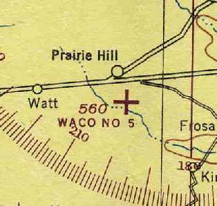
"Waco #5", as depicted on the January 1945 Austin Sectional Chart (courtesy of Chris Kennedy).
Photo of the airfield while in use has not been located.
This airfield was used during WW2 as one of 3 satellite airfields for Waco AAF (20 miles west-southwest),
which was a training center for Army Air Force flight instructors.
The date of construction of the airfield has not been determined.
It was not yet depicted at all on July 1943 Austin Section Chart (courtesy of Richard Doehring).
The earliest depiction of the airfield which has been located
was on the January 1945 Austin Sectional Chart (courtesy of Chris Kennedy).
It labeled the field as "Waco #5".

The 1945 AAF Airfield Directory (courtesy of Scott Murdock) described “Waco AAF Auxiliary #5 (Prairie Hill Field)”
as a 490 acre property within which were 3 concrete runways, measuring 4,000' north/south & northwest/southeast & 3,500' east/west.
The field was said to not have any hangars, but a ramp was depicted on the west side.
The field was said to be owned by the U.S. Government & operated by the Army Air Forces.
By the time of the February 1949 Austin Sectional Chart (courtesy of Chris Kennedy),
the field has been renamed "Prairie Hill AF",
and it was described as having a 4,000' hard-surface runway.

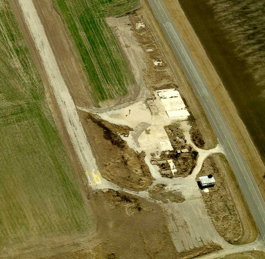
A 9/13/55 USGS aerial photo depicted Prairie Hill as having 3 paved runways, with closed-runway “X” symbols on the east/west & northwest/southeast runways.
A paved ramp was on the west side, but there were not any buildings seen on the field.

The 1957 USGS topo map depicted the "Prairie Hill Air Force Auxiliary Field"
as having 3 paved runways, with a paved ramp on the west side of the field.
It did not depict any buildings on the field.
The Prairie Hill airfield was abandoned by the Air Force by 1966,
as it was labeled “Prairie Hill AF Aux (Closed) on the 1966 Austin Sectional Chart (courtesy of John Price).
Vic Moreland recalled, “I drag raced a lot at Prairie Hill in the 1960s.”
Even after the airfield was disposed of, the northwest corner of the property was retained by the USAF
& became the Prairie Hill Radio Beacon Annex.
It was active for several years.
![]()
A 1994 photo by Scott Murdock of the building of the former Prairie Hill Radio Beacon.
As seen in a 11/3/11 aerial photo, the Prairie Hill airfield consisted of 3 paved 4,100' runways, a small paved ramp & the radio beacon building.
The Prairie Hill Airfield is located on the west side of Ranch Road 339, less than a mile south of the town of Prairie Hill.
____________________________________________________
Since this site was first put on the web in 1999, its popularity has grown tremendously.
That has caused it to often exceed bandwidth limitations
set by the company which I pay to host it on the web.
If the total quantity of material on this site is to continue to grow,
it will require ever-increasing funding to pay its expenses.
Therefore, I request financial contributions from site visitors,
to help defray the increasing costs of the site
and ensure that it continues to be available & to grow.
What would you pay for a good aviation magazine, or a good aviation book?
Please consider a donation of an equivalent amount, at the least.
This site is not supported by commercial advertising –
it is purely supported by donations.
If you enjoy the site, and would like to make a financial contribution,
you
may use a credit card via
![]() ,
using one of 2 methods:
,
using one of 2 methods:
To make a one-time donation of an amount of your choice:
Or you can sign up for a $10 monthly subscription to help support the site on an ongoing basis:
Or if you prefer to contact me directly concerning a contribution (for a mailing address to send a check),
please contact me at: paulandterryfreeman@gmail.com
If you enjoy this web site, please support it with a financial contribution.
please contact me at: paulandterryfreeman@gmail.com
If you enjoy this web site, please support it with a financial contribution.
____________________________________________________
This site covers airfields in all 50 states.