
 ABSTRACT (228KB) abstract; introduction (258KB) oceanograph; sediments; bathymetric map (297KB) sediments; airphoto of Icacos Point (268KB) sediments; currents; airphoto of Columbus Bay coast
(248KB) currents; grainsize parameter plots: mean, sorting, %
fines (272KB) currents; maps of bottom- and surface currents (267KB) sediment transport; table of data about currents
(273KB) erosion; table of erosion and accretion data (307KB) coastal changes near Corral Point; photograph of
fallen palmtrees (246KB) map of coastal changes near Corral Pt, 1906-1982;
summary (272KB) bathymetric profile showing drowned stacks off Three
Sisters (259KB) references; photograph of bottom sediments stirred up
by pirogues (196KB)
ABSTRACT (228KB) abstract; introduction (258KB) oceanograph; sediments; bathymetric map (297KB) sediments; airphoto of Icacos Point (268KB) sediments; currents; airphoto of Columbus Bay coast
(248KB) currents; grainsize parameter plots: mean, sorting, %
fines (272KB) currents; maps of bottom- and surface currents (267KB) sediment transport; table of data about currents
(273KB) erosion; table of erosion and accretion data (307KB) coastal changes near Corral Point; photograph of
fallen palmtrees (246KB) map of coastal changes near Corral Pt, 1906-1982;
summary (272KB) bathymetric profile showing drowned stacks off Three
Sisters (259KB) references; photograph of bottom sediments stirred up
by pirogues (196KB)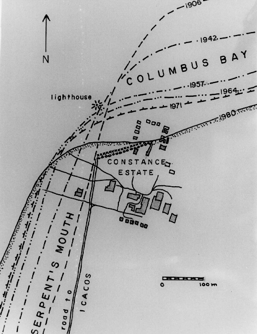
or
 modified: December 25, 1998