The history
of what today is the State of Veracruz can be divided into three lengthy
and equally
important periods,
covering a timespan of nearly 3,500 years. These periods are as follows:
The pre-Colombian:
1200 B.C. to 1519 A.D.
The Colonial:
1519 to 1821 A.D.
The independence:
1821 A.D. to the present
Several indigenous
cultures flourished in Veracruz in the pre-Colombian period, cultures still
carefully
studied by
archaeologists. The principal cultures were the Olmecas, the Huastecos
and the
Totonacas.
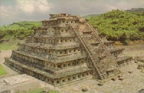
Impressive ruins of the Totonacas can still be visited throughout the state,
with the
principal archaeological
sites at El Tajin and Zempoala. The state capital of Xalapa is justifiably
famous for
its archaeological museum.

 |
Veracruz state offers an extremely diverse
orographic conformation, due primarily to the eastern Sierra Madre mountain
range which crosses the entire length of the state, at times touching its
coastal zones.
Hydrology Of The State Veracruz state has some of the country's most
important hydrological basins, derived from the rainfall and snow runoffs
from the eastern Sierra Madre. As one direct result, close to 35% of Mexico's
water supply is found in the state. The most important hydrological basins
emanate from the Panuco, Coatzacoalcos, Papaloapan, Tuxpan and Antigua
Rivers.
|
 Main
pageNext
page
Main
pageNext
page
If you have comments or suggestions, email me at JoaquinDorantes@netscape.net
