|
Ranong
is Thailand least populated Province. The land in this province
is made up of 80% forest and 67% of which is in hilly terrain. The
region also undergoes the 2 monsoons period. As a result of that
record of rainfall is high and happens frequently, a gentleman
has made a joke the Ranong was actually a wrongly pronounced
"Rain On".
 |
The
distinct impression of this province comes from the fact
that the narrowest part of the Isthmus of Kra lies in this
province. At this point, the isthmus nearly 50
kilometers wide separates the Indian Ocean and the Gulf
of Thailand.
|
The
economy of this region comes from fishing and minerals mining.
Agriculture in the form of rubber estates and cashew nuts
production is also seen in many places.
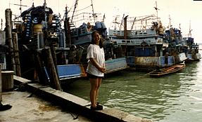 |
The main
activities of the provincial town is fishing. Fleets of
marvelous looking 3 deckers lined up besides its jetty.
The Andaman Seas within the Burmese territory is
relatively unexploited and the whole area is still rich
with sea based produce. |
| For
hundreds of miles around Ranong is the only large town
that has the infrastructure to support large scale
fishing operations. Here Burmese boats or boats manned by
Burmese are frequent scenes. |
 |
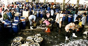 |
Saphaan
Plaa is bursting with life. Fishing boats are constantly
unloading its catches. Then, they reload their boats with
the needed supply to go out to sea. We had never seen so
much fishes and such a large market anywhere! |
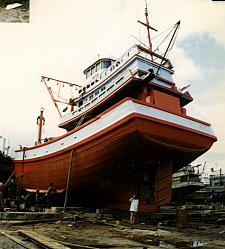 |
This is
also the place with the largest ship building yard. New
ships are built, old ones repaired and maintained. Owners of fishing
fleets around the region acknowledged their expertise and
this is evident by the large volume and we were told of
the fast turnaround time.
|
While
this region is noted for its highest rainfall and large tract of
forested areas, there are very few notable waterfalls. On the
Highway 4 down from Ranong to Takuapa, numerous signs in Thai
give clues of waterfalls existing in the region that we have not
verified, but the 2 notable one are:-
Name
of Waterfall
|
Its
Location
|
Linked
|
|
|
Along Highway 4, 15
kilometers north of town |
Linked |
|
|
Along Highway 4, 20
kilometers south of town |
|
The Punyaban Waterfall
 |
Along
Highway 4 while going north to exit Ranong this signboard
prominently display the distance.
The Waterfall is
just beside the Highway. This is also a well visited area
with a souvenir shop and tea house.
|
|
The
waterfall is a single vertical drop of about 30 meters
high. The space in front of the fall is open to give a
dramatic full view of the fall and its surrounding.
Shop owners has also
erected a pavilion across the path of the waterfall for
visitor to have a vantage point to enjoy the waterfall
scene.
|
|
|


