
Abandoned & Little-Known Airfields:
Arizona: Southeastern Phoenix area
© 2002, © 2016 by Paul Freeman. Revised 8/28/16.
This site covers airfields in all 50 states: Click here for the site's main menu.
____________________________________________________
Please consider a financial contribution to support the continued growth & operation of this site.
Florence Junction Airport (1st location) (revised 8/26/14) - Florence Junction Airport (2nd location) (revised 5/12/13)
Francisco Grande Airfield (revised 8/26/14) - Gilbert Airport (revised 4/15/14) - Gilbert Aux AAF #1 (revised 4/15/14)
Goodyear AF Aux / Chandler Memorial Airfield / Gila River Memorial Airport (revised 8/12/16)
Rittenhouse Aux AAF #2 (revised 2/6/16) - Tempe Airport (revised 4/15/14) - Three Point Airport (revised 8/28/16)
____________________________________________________
Florence Junction Airport (1st location), Florence Junction, AZ
33.255, -111.347 (Southeast of Phoenix, AZ)
The original location of Florence Junction Airport, as depicted on the 1954 USGS topo map.
The original Florence Junction Airport was evidently established at some point between 1950-52,
as it was not yet listed among active airfields in the 1945 AAF Airfield Directory (courtesy of Scott Murdock)
nor depicted on the 1950 Gila River World Aeronautical Chart (according to David Brooks).
The earliest depiction which has been located of the Florence Junction Airport
was on the 1952 Phoenix Sectional Chart (according to David Brooks),
which described the field as having a 5,200' dirt runway.
The 1954 USGS topo map depicted the Florence Junction Airport to the southwest of the crossroads.
The 1955 Phoenix Sectional Chart (according to David Brooks)
described the Florence Junction Airport as having a 3,200' “turf” runway (probably not much “turf”).
The original Florence Junction Airport was evidently closed at some point between 1955-57,
as it was no longer depicted on the 1957 Phoenix Sectional Chart (according to David Brooks).
It was evidently replaced by a paved runway on the northeast side of the crossroads.

The earliest photo which has been located of the Florence Junction Airport was an 8/1/61 USGS aerial view.
It depicted the field as having a single unpaved northeast/southwest runway,
along with a few small buildings along the road on the northeast side of the field.
There did not appear to be any signs of recent aviation usage.
However the Florence Junction Airport continued to be listed in the 1968 AOPA Airport Directory (according to David Brooks),
and described as having a 5,000' dirt runway.

The 1966 USGS topo map depicted the original Florence Junction Airport as having a single unpaved northeast/southwest runway,
labeled simply as “Landing Strip”, with a few small buildings on the northeast side next to the road.

The 5/16/92 USGS aerial view looking southwest showed the remains of the Florence Junction runway,
along with a few small buildings along the road on the northeast side of the field.
A 2003 aerial photo showed that at some point between 1992-2003
the northeast end of the Florence Junction runway was covered by a rerouted portion of Route 60.
A 2007 aerial view showed that the buildings at the northeast end of the airport site had been removed at some point between 2003-2007.

A 2/23/10 aerial view looking southwest showed that the northeast end of the Florence Junction runway was covered by a rerouted portion of Route 60,
but the outline remained recognizable of the majority of the runway length.
The site of the original Florence Junction Airport is located southwest of the intersection of Route 60 & Route 79.
____________________________________________________
Florence Junction Airport (2nd location), Florence Junction, AZ
33.261, -111.331 (Southeast of Phoenix, AZ)

The 2nd location of the Florence Junction Airport, as depicted on an 8/1/61 USGS aerial photo.
At some point before 1961, the original Florence Junction Airport was evidently replaced by another runway on the northeast side of the crossroads.
The earliest depiction which has been located of the 2nd location of Florence Junction Airport was an 8/1/61 USGS aerial photo,
which depicted a single unpaved northeast/southwest runway, with some buildings on the west end.
This 2nd location of Florence Junction Airport was not depicted at all on the 1966 USGS topo maps, nor on later topo maps.
Jason Johnson recalled a landing at this location of the Florence Junction Airport:
“I landed there some 15 years ago [1986], and it was in OK shape then.
We were in a 1946 Luscombe, braking in a new engine, and the oil temperature started to run away,
so we decided to land there & walk to a nearby Circle K for a soda while the engine cooled down.”

A 5/16/92 USGS aerial view looking east at the remains of the 2nd location of the Florence Junction Airport
depicted the field as having a single east/west 3,400' paved runway, with a complex of buildings along the south side.
A 2003 aerial photo showed a closed-runway “X” symbol on the east end of the Florence Junction runway.

A 2/23/10 aerial view looking east showed that the paved runway of the 2nd location of the Florence Junction Airport remained intact.
The site of the 2nd location of the Florence Junction Airport is located northeast of the intersection of Route 60 & Route 79.
____________________________________________________
Francisco Grande Airfield, Casa Grande, AZ
32.884, -111.858 (Southeast of Phoenix, AZ)

An undated (circa late 1950s – early 1960s) photo of an unidentified woman & Pat Boone on horseback in front of a Twin Commander at Francisco Grande,
with the resort tower under construction in the background.
In 1959 the San Francisco Giants' owner Horace Stoneham developed Francisco Grande
as a spring training camp for his popular Major League Baseball team.
The name of the property was taken from the San "Francisco" Giants and Casa "Grande".
During its early years, the hotel was popular with celebrities like John Wayne and Pat Boone.

The 1965 USGS topo map depicted a single unpaved northwest/southeast “Landing Strip” with a taxiway leading to the Francisco Grande property.
The Francisco Grande Airfield was not yet depicted on the January 1966 Phoenix Sectional Chart (according to Chris Kennedy).
The earliest aeronautical chart depiction which has been located of the Francisco Grande Airfield
was on the January 1968 Phoenix Sectional Chart (according to Chris Kennedy).
It depicted Francisco Grande Airfield as having a 5,000' runway.

An undated (circa 1960s) photo of an unidentified man & Pat Boone on a Piper at Francisco Grande.

The earliest aerial photo which has been located of Francisco Grande Airfield was a 1971 USGS aerial view.
It depicted both the WNW/ESE runway on the west side of North Montgomery Road & the NNW/SSE runway on the east side.

A 1973 photo by Brian Baker of Snow S-2A N9458R cn 10934 at Francisco Grande, with a DC-7 in the background.
Brian recalled, “I recall that it was near some kind of resort hotel.
There wasn't much there, but it had to have been enough to get that DC-6 or DC-7 in there.
That's a rare early Snow. I shot 3 different views of the airplane, and none shows any building in the background, only some lightplanes & the DC-7.
I don't think there were any hangars there.
There is, however, a Chevron self serve gas pump visible in one photo, so there had to have been an operator there of some kind.
There is a second DC-7B in the background, but I don't have any photos of it.”
The 1976 AOPA Airport Directory (according to Chris Kennedy)
described Francisco Grande Airfield as having a single 5,000' dirt Runway 9/27.
The Francisco Grande Airfield was evidently closed (for reasons unknown) at some point in 1976,
as it was no longer depicted on the December 1976 Phoenix Sectional Chart (according to Chris Kennedy).

The 1977 USGS topo map depicted Francisco Grande as having a single WNW/ESE runway
on the west side of North Montgomery Road.
Evidently the airfield was not reused by subsequent owners of the facility.
After the Giants moved their Spring Training operations to Scottsdale,
the California Angels used Francisco Grande from 1982-84.
From 1984-86, the baseball fields were transformed into football fields,
which were used as the training camp headquarters for the USFL's Arizona Wranglers & the Denver Gold.
In 1984 the Francisco Grande reopened as a destination golf resort.

The 1994 USGS topo map once again depicted a shorter runway oriented NNW/SSE on the opposite side of North Mongtomery Road, closer to the resort.

The 1996 USGS aerial view showed the remains of a single unpaved northwest/southeast runway on the west side of the Francisco Grande property.
In 2003, the Francisco Grande resort was closed for an $8.5 million renovation, reopening in 2005.

A 6/8/07 aerial view looking north (enhanced by Bill Grasha) showed the remains of a single unpaved northwest/southeast runway on the west side of the Francisco Grande property.

A pre-2010 aerial view looking west at the Francisco Grande runway.

A pre-2010 photo looking southeast along the remains of Francisco Grande's Runway 15.
The site of Francisco Grande Airfield is located northwest of the intersection of Gila Bend Highway & North Candlestick Drive.
Thanks to Gary Alexander for pointing out this airfield.
____________________________________________________
33.406, -111.95 (Southeast of Phoenix, AZ)
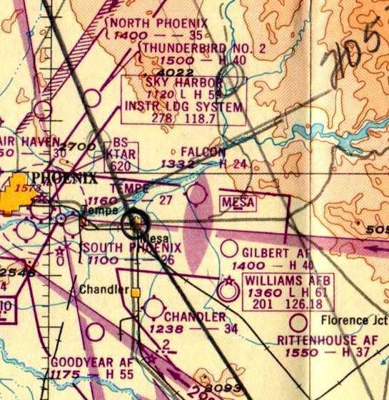
Tempe Airport, along with an amazing array of other airfields in the Phoenix area, as depicted on the 1947 Gila River World Aeronautical Chart.
Tempe Airport was not yet depicted at all on a 1937 aerial photo
nor on the 1945 Phoenix Sectional Chart (courtesy of John Voss).
According to Ron Chavez's book “The Valley's Airports of the Past”,
“Tempe Airport started its operations in 1946 by founders C. Stallings & J. Wigley.
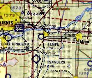
Tempe Airport was located on the southwest corner of Broadway Road & Mill Avenue,
and had a single 2,700' east/west dirt runway.
After having a hangar constructed, Stallings & Wigley would manage the airport as its owner/operators.
Besides running the airport, Stallings & Wigley also started a flight school with both men operating as flight instructors.”
The earliest depiction of Tempe Airport which has been located was on the 1947 Gila River World Aeronautical Chart.
It depicted Tempe as having a 2,700' unpaved runway.

The 1949 Phoenix Sectional Chart (courtesy of Chris Kennedy) depicted Tempe as having a 2,700' unpaved runway.

A circa 1946 – 1950s advertisement for Tempe Airport Inc. (from Ron Chavez's book “The Valley's Airports of the Past”, enhanced by Bill Grasha).
According to Doug Duncan, Tempe Airport “was located just south of Broadway (west of Tempe High School)
between the railroad tracks & the wires. I think it was never paved.”

The earliest photo which has been located of the Tempe Airport
was a 2/17/49 aerial view (from the Maricopa County Flood Control District , enhanced by Bill Grasha).
It depicted the field as having a single unpaved east/west runway with a parallel taxiway,
along with what appeared to be traces of 2 former crosswind runways.
A total of 16 single-engine aircraft were parked around a few small buildings on the north side of the field.

The 1952 USGS topo map (courtesy of John Arthur)
depicted Tempe Airport as having a as having a single east/west runway, with one building (a hangar?) on the north side of the field.
According to Ron Chavez's book “The Valley's Airports of the Past”,
“Stalling & Wigley would continue to operate the Tempe Airport until 1954,
when they sold the airport business & the property to the City of Tempe.”
The 1956 Phoenix Sectional Chart depicted Tempe Airport as having a 2,700' unpaved runway.
John Arthur placed the location of Tempe Airport as “On Broadway, west of Mill Avenue & the railroad tracks,
next to Date Palm Manor, across from the High School.
I remember the area as a big empty field in the mid & late 1950s.
I remember Date Palm Manor even better because of all the scorpions in the bark of the palms.”
According to Ron Chavez's book “The Valley's Airports of the Past”,
“The City of Tempe continued to run the airport until 1957,
then closed it down to make room for new development that was being planned in the area.”
According to Doug Duncan, Tempe Airport “was razed in 1957.”

A 1958 aerial view (courtesy of John Arthur) depicted the site of the Tempe Airport.
Traces of the former east/west runway were still perceptible,
but overall the property appeared to have been razed.
Tempe Airport was no longer depicted on the July 1965 Phoenix Sectional Chart (courtesy of Ron Kunse).
Doug Duncan reported in 2007, of the Tempe Airport, “Even the Tempe Historical Museum people knew nothing about it!
I've looked at aerial photos & have driven around the area, but there appears to be no visible trace remaining.”

As seen in a 2007 aerial photo, the site of Tempe Airport has been heavily redeveloped, and not a trace of the former airport appears to remain.
____________________________________________________
Three Point Airport (E58), Casa Grande, AZ
32.9, -111.76 (Southeast of Phoenix, AZ)

Three Point Airport, as depicted on the February 1943 Phoenix Sectional Chart (courtesy of Chris Kennedy).
This small privately-owned public-use airport was apparently built at some point between 1941-43,
as it was not listed among active airfields in The Airport Directory Company's 1941 Airports Directory (according to Chris Kennedy).
The earliest depiction of Three Point Airport which has been located
was on the February 1943 Phoenix Sectional Chart (courtesy of Chris Kennedy).
The 1944 US Army/Navy Directory of Airfields (courtesy of Ken Mercer)
described Three Point Airport as having a 3,500' unpaved runway.
Three Point Airport was still depicted as an auxiliary airfield
on the 1945 Phoenix Sectional Chart (courtesy of John Voss).

The 1960 Jeppesen Airway Manual (courtesy of Chris Kennedy)
depicted Three Point Airport as having a total of 4 unpaved runways,
with the longest being the 4,000' Runway 1/19.
Three buildings (hangars?) were depicted along the east side of the field.

The earliest photo which has been located of Three Point Airport was a 5/25/61 USGS aerial photo.
It depicted Three Point as having a single unpaved north/south runway,
with several small buildings & 7 light aircraft along the east side of the field.
The 1962 AOPA Airport Directory described Three Point as having a 4,000' sod Runway 18/36
(a 'sod' runway - in the Arizona desert??).
The operator was listed as George Gomez.

The last aeronautical chart depiction which has been located of Three Point Airport
was on the July 1965 Phoenix Sectional Chart (courtesy of Ron Kunse).
It depicted Three Point as having a 3,800' unpaved runway.

A 9/9/68 photo of Piper PA-25 Pawnee N7437Z (25-3423) getting a token wash down at Three Point Airport.
The 1982 AOPA Airport Directory (courtesy of Ed Drury)
more realistically described the runway configuration at Three Point as being a single 3,850' "dirt, oiled" Runway 17/35.
According to Dan Rhinehart, Three Point "was never paved & had 2 dirt runways.
Three Point airport was owned & operated by George Gomez & family
until the death of Mrs. Gomez, who ran the airport restaurant until she died.
Three Point was typical of the duster strips / privately-owned public-use airports in Arizona,
however it was the last one to go."
In a 1991 meeting of the Casa Grande City Council,
George White stated he represented the Estate of Marlene White & Adele Gomez, the owners of Three Point Airport.
They did not want to be annexed into the City because of the increase in taxes.
They also did not want to be required to make any improvements other than what the County required.

The 1995 USGS topo map depicted Three Point Airport as having a single north/south unpaved runway,
with a few small buildings along the east side of the field.

A 10/1/96 USGS aerial view looking northwest at Three Point Airport showed a single north/south dirt runway,
with a few small hangars along the east side of the field.
There did not appear to be any aircraft visible on the field.
A 1997 aerial photo showed the Three Point Airport property still remaining clear.
The last aeronautical chart depiction which has been located of Three Point Airport was on the 1998 World Aeronautical Chart.
Three Point Airport was evidently closed (for reasons unknown) at some point between 1998-2000,
as it was no longer listed among active airfields in the 2000 AOPA Airport Directory.
A 2003 aerial photo showed the west & north sides of the Three Point Airport property had begin to be covered by housing.

A 2003 photo by Dan Rhinehart, looking south along the former runway at Three Point Airport.
Dan reported, “The hangar & covered tie-downs are gone but the rest of the airport is pretty much there.”

A 2003 photo by Dan Rhinehart (enhanced by Bill Grasha), looking east along the former runway at Three Point Airport.

The last photo which has been located of an aircraft at Three Point Airport was a 2003 photo by Dan Rhinehart of an Aerospatiale Alouette III & Aerospatiale Llama
at the helicopter firm which still operated at the former Three Point Airport.

A 2003 photo by Dan Rhinehart of the Airport Tavern, adjacent to the former Three Point Airport.
Dan reported, “Even though Three Point is no longer listed as an airport (closed or otherwise)
the current owner of the airport restaurant said 'If you want to land & come in for lunch that it was fine with me!'"

A 2014 aerial view looking northwest showed the western half of Three Point Airport had been covered with housing,
but a southern portion of the north/south runway remained recognizable, and a few airport buildings remained along along the east side of the field.
The site of Three Point Airport is located southwest of the intersection of Route 387 & West Kortsen Road.
____________________________________________________
Williams Auxiliary Army Airfield #6 / Goodyear AF Auxiliary / Chandler Memorial Airfield (L07) /
Gila River Memorial Airport (34AZ), Chandler, AZ
33.24, -111.91 (Southeast of Phoenix, AZ)

A circa 1943-45 aerial view looking northeast at Williams Auxiliary Army Airfield #5 from the 1945 AAF Airport Directory.
This field was built during WW2 as Williams Auxiliary Army Airfield #5,
one of several satellite airfields for Williams AAF,
which conducted training in twin & 4 engine bombers & single engine fighters.
Williams Auxiliary Army Airfield #5 was evidently built at some point between 1943-45,
as it was not depicted at all on a 1937 aerial photo nor on the 1943 Phoenix Sectional Chart (courtesy of Chris Kennedy).
The earliest photo which has been located of Williams Auxiliary Army Airfield #5
was a circa 1943-45 aerial view from the 1945 AAF Airport Directory.
The 1945 AAF Airfield Directory (courtesy of Scott Murdock) described “Williams Field Auxiliary #5 (Goodyear Field)”
as a rectangular property having 2 paved 5,500' runways,
oriented northeast/southwest & northwest/southeast,
along with an oiled “All-way area” measuring 2,675' east/west by 1,000' north/south.
The field was described as not having any hangars,
and to be operated by the Army Air Forces.
The 1947 Gila River World Aeronautical Chart depicted Goodyear AF as having a 5,500' paved runway.
A directory of AZ Airports in the 5/47 issue of Arizona Highways (courtesy of George Miller)
described Williams Aux AAF #5 as being unattended, and the longest runway as being 4,000'.

Goodyear AF Aux Airfield, as (partially) depicted on the southern edge
of the 1948 USAF Phoenix Urban Area Chart (courtesy of Scott O'Donnell).
It depicted “Goodyear AF Aux Airfield” as having 2 paved runways with a taxiway & a ramp on the north side of the field.

A 2/17/49 aerial view (from the Maricopa County Flood Control District).
depicted Goodyear Auxiliary Airfield in its original (triangular) configuration, with 2 paved runways & a ramp on the north side of the field.
No aircraft or buildings were present on the field.

The 1952 USGS topo map still depicted “Goodyear Air Force Auxiliary Airfield” in its original WW2 configuration.
The primary runway was apparently lengthened at some point between 1952-56,
as the 1956 Phoenix Sectional chart (courtesy of John Voss) described the field as having a 8,000' runway.
The lengthening was presumably to support jet aircraft training operations from nearby Williams AFB.

A 1958 aerial view (courtesy of John Arthur) depicted the Goodyear Auxiliary Airfield with its lengthened northwest/southeast runway.
It was still depicted as "Goodyear AF" on the 1966 Phoenix Local aeronautical chart (courtesy of John Voss).

The Air Force apparently relinquished the airfield at some point between 1966-71 & it became a civilian airfield.
That is how "Goodyear" was depicted on the August 1971 USAF Tactical Pilotage Chart (courtesy of Chris Kennedy).
Eventually, the field became a private civil airport, Memorial Airfield.
This airfield was supposedly used during Vietnam War to modify C-130s & other aircraft used by Air America & other companies.

A pre-1970 aerial view looking west at Memorial Airfield by Chris Kennedy (enhanced by Bill Grasha).
The airfield appears completely unused, with no buildings at all, and no aircraft on the ramp.

A 1970 aerial view showed a large number of twin-engine & 4-engine transport aircraft at Memorial Airfield.
Two large hangars had been added on the ramp on the north side of the field,
along with a row of smaller hangars.
A 12/15/79 aerial view (from the Maricopa County Flood Control District)
showed 3 hangars on the ramp on the north side of the field.
A total of 13 aircraft were visible on the field, including 6 large twin & 4-engine piston-engine transports.

The only photo that has been located of an aircraft operating from Memorial Airport was a 5/5/82 photo of Lockheed L1649A-98 Starliner, N8083H (enhanced by Bill Grasha).
At the time it was one of only 4 airworthy Starliners in the world.

An October 1982 photo by Micheal Zoeller (enhanced by Bill Grasha) of a Fairchild C-119F Flying Boxcar operated by Hawkins & Powers Aviation seen at Chandler Memorial Airfield.

A 9/10/88 aerial view by Brian Baker (enhanced by Bill Grasha) looking southwest at Memorial Airport,
showing more than a dozen large piston-engine airliners on the ramp along with several hangars.
Paul Freeman flew into Memorial in an MD-500 helicopter in 1990
on a training flight for the McDonnell Douglas Helicopter Company (located nearby in Mesa).
The company used Memorial Airfield for helicopter pilot training flights.
The airfield consisted of 2 paved runways (the longest, 12/30, was 8,500'), ramps & hangars.
The runways were very deteriorated, with weeds growing up through cracks.
A 2/6/92 aerial view (from the Maricopa County Flood Control District)
showed the number of aircraft on the Memorial ramp had increased to over 2 dozen.

An October 1997 photo of N415FM, a beautiful 1963 Fouga CM-170 Magister, serial #415, at Chandler Memorial Airport.

A 2002 aerial view by Ralph Pettersen looking west at C-130s, DC-7s, and other aircraft on the Memorial ramp.

A beautiful 2002 shot by Nils Alegren of DC-7s, some of the many old transports baking in the sun at Memorial.
As of 2002, several air tanker companies based a variety of aircraft (C-130, DC-7) at Memorial.
However, as a local AZ pilot pointed out in 2002, "Now with the FAA ban on using C-130As for aerial firefighting,
most of those old C-130s at Memorial will probably go into being Budweiser cans!"

A 2003 aerial view looking north at Memorial Airfield by James Covington.
Sam Brunetto reported in 2005 that “ABVA Trust International
has asked me to do a cost evaluation of a complete development project to bring Memorial into the 21st century.
After doing a cost evaluation , I presented it to ABVA.
I have obtained an agreement with them for funds in $100 million blocks up to $1 Billion.”

A 2005 photo looking southeast along Memorial's Runway 12 (courtesy of Luke Graven of North America Building & Development).

A 2005 photo looking south at Memorial's ramp (courtesy of Luke Graven of North America Building & Development).

A circa 2006 aerial view looking west at a fenced-in boneyard containing dozens of Sikorsky helicopter fuselages at Chandler Memorial,
a Douglas DC-7, and 3 DC-7 nose sections.

A circa 2006 aerial view looking west at a group of 4 Lockheed Venturas at Chandler Memorial,
one of which was missing its tail.

A 2006 photo (courtesy of Luke Graven of North America Building & Development) of the newly repaved Runway 12/30 at Memorial.
Luke reported in 2006, “We have resurfaced the main runway & taxiway with some slurry-seal 8,600' x 75’.
We're flying our Lear 35 out of here... it's great having an 8,600' runway all to yourself.”

A 2006 plan (courtesy of Luke Graven of North America Building & Development) looking west at the plan for the redevelopment of Memorial.
Luke reported in 2006, “We will hopefully soon reach a deal with the Gila River Airport Authority & develop the airpark.”

A 2006 artist's conception (courtesy of Luke Graven of North America Building & Development)
of the entrance to the planned “Gila River Airport” (to be developed on the site of the Memorial Airfield).

A 2006 artist's conception (courtesy of Luke Graven of North America Building & Development) of the planned tower.

A 2006 artist's conception (courtesy of Luke Graven of North America Building & Development) of the stunning native-style hangars.

A 2007 photo by Ryan Keough looking along a runway (or taxiway?) at Gila River Memorial (enhanced by Bill Grasha),
with several C-130s visible in the background.
Ryan Keough reported in 2007, “Most of the aircraft are being either trucked away
from Chandler Memorial (now known as Gila River Memorial Airport)
as the Gila River Reservation determines what the fate or the airfield will be.
Many of the DC-6s were cut up & scrapped.
The 4 PV-2 Harpoon/Howard 500s that are there are being disassembled or prepped for ferry flights.
The 4 former Biegert Aviation C-54s are in limbo & no one is sure if they will be scrapped or not. They are far from flyable.
A huge collection of H-19 Chicksaw helicopter airframes have been trucked away.
The 2 C-130s owned by International Air Response have been flown to Coolidge to join the others already there.”

A January 2009 aerial view by Doug Wilson looking southwest at Chandler Memorial Airport (enhanced by Bill Grasha).
Doug reported, “It appears there are still at least 5 DC-4 through DC-7 series aircraft, and it looks like maybe 2 Lockheed Lodestars.
Four of the DC series are together, not having moved for some years, and the 5th is near the main hangar.
Three smaller hangars have since been dismantled (lower left in the shot), and it appears all the helicopter remains have been trucked away.
Only the large, main hangar & 2 smaller outbuildings remain.”

A January 2009 aerial view by Doug Wilson looking southwest at the aircraft on the Chandler Memorial Airport ramp (enhanced by Bill Grasha).
Evidently the grandiose “Gila River Airport” redevelopment plans from 3 years ago have not yet come to pass, for reasons unknown.
Frank Gazzano reported in December 2009, “I drove out to the field to see what was going on, it always was an interesting place to scout out.
Almost all the stored / boneyard aircraft are gone & all the hangars except the main one have been demolished.
There is now security on site that politely asks you to leave, they say that no one is flying in or out of Memorial anymore.
It will come back up again in 10–20 years when Phoenix goes through its next boom cycle.
It is in close proximity to several Indian gaming casinos, two of which are trying to cater to high rollers, which of course means jet aircraft.”

The 2014 Phoenix Terminal Aeronautical Chart depicted Gila River Memorial as a private airfield with 2 paved runways.
____________________________________________________
33.345, -111.795 (Southeast of Phoenix, AZ)

Gilbert Airport, as depicted on the 1949 Phoenix Sectional Chart.
According to an article by Kelly Mixer in the Apache Junction Independent (courtesy of Chris Root),
Gilbert Airport was built in 1946 by Bill Mastin & his brother-in-law, Joseph Wilbur.
It was established “on Everett Wilbur's property, which ran an eighth of a mile west of Gilbert Road to Neely Street,
south to Mesquite Street, and north to Palo Verde Street.
The duo started the Wilbur Flying Service that same year with one training plane. They later purchased more.
Gilbert Airport had a hangar, repair shop, office, pilot lounge & hard-packed dirt runway.”
"We had a 100' wide landing strip that ran east/west because the winds recorded easterly back then," Mr. Mastin said.

An undated photo (enhanced by Bill Grasha) of Bill Mastin, on top of a Beech Bonanza, possibly at Gilbert Airport.
According to the article in the Independent, “The airport was equipped with a Unicom transceiver
and floodlights were installed to make night operations possible.
When they first opened the airport, the duo taught World War II veterans how to fly
because the Wilbur Flying Service was approved by the state & Veterans Administration for G.I. flight training.
Eventually, they added a charter plane service.”
"A lot of people from Williams AFB also took lessons when they were not serving in active duty," Mr. Mastin said.
According to the article in the Independent, “A partial roster of pilots & students who flew at Gilbert Airport
is on display at the Gilbert Historical Museum on the southwest corner of Gilbert & Elliot roads.
Among the notable aviators who learned to fly in Gilbert was Darrel Sawyer, owner & founder of Sawyer Aviation.
In 1947, Mr. Sawyer served as vice-president of the newly formed Gilbert Model Airplane Club, called the Gilbert Flying Tigers.
The group regularly met at the Gilbert Airport to fly their homebuilt model airplanes & compete against other model-airplane clubs.”
According to the article in the Independent, “In 1948, Mr. Mastin purchased Joe Wilbur's interest in the business
and became sole owner of the Gilbert Airport.
He kept the Wilbur Flying Service name & continued to work there as the airport's flight instructor.
At its peak in the late 1940s, as many as 20 airplanes were based at the field.
Mr. Mastin trained hundreds of local pilots.
A lot of people would fly for awhile & then quit because they couldn't afford to buy their own plane," he said.
According to the article in the Independent, “As VA flight training came to an end after the 1940s,
Mr. Mastin began to look at other ways to increase his revenue at the airport.
He had worked as a photographer so he added aerial photography to the list of services at the airport.”
The earliest aeronautical chart depiction of the field which has been located was on the 1949 Phoenix Sectional Chart.
It depicted Gilbert Airport as having a 2,300' unpaved runway.

The earliest photo which has been located of the Gilbert Airport
was a February 17, 1949 aerial view (from the Maricopa County Flood Control District).
It depicted the field as having a single unpaved east/west runway with a parallel taxiway.
A total of 5 single-engine aircraft were parked around a few small buildings on the southeast side of the field.
![]()
A 1952 Chevron road map depicted Gilbert Airport as having an east/west oriented property outline.

A circa 1950s photo (enhanced by Bill Grasha) showing 4 taildraggers & 2 hangars at Gilbert Airport.
According to the article in the Independent, “By the mid-1950s, crop-dusting had become the principal business at the airfield.”
"That was my main source of income until farmers realized they could do it cheaper themselves by using their tractors," Mr. Mastin said.

The last aeronautical chart depiction which has been located of Gilbert Airport
was on the 1956 Phoenix Sectional Chart (courtesy of John Voss).
It depicted the field as having a 2,300' unpaved runway.
According to the article in the Independent, “Eventually, the parallel taxiway was widened & used as the runway,
leaving most of the airport property available for cultivation.”
"I farmed the property for awhile but after a lot of hard work, I only managed to break even," Mr. Mastin said.
According to the article in the Independent, “In 1959, the Gilbert Unified School District
announced plans to acquire some of the property for a new high school.
The purchase was completed following approval by the district's voters.
Mr. Mastin held on to 2 airport buildings & the runway so he could continue his crop-dusting business.”

A February 19, 1959 aerial view (from the Maricopa County Flood Control District)
depicted Gilbert Airport after the majority of the field had been converted back to farmland,
with the former parallel taxiway now being used as the runway.
The decline of the airport was noticeable in contrast to the 1949 photo, in that no aircraft were visible on the field.
According to the article in the Independent,
Mr. Mastin continued his use of the airfield for “his crop-dusting business until around 1962 or 1963.
The main hangar was sold to a cabinet-making business,
while the repair shop was sold to the owner of the local Union service station.”
A 12/15/79 aerial view (from the Maricopa County Flood Control District)
showed the 2 former hangars still standing on the east side of the property,
which had otherwise been covered with houses & a school.
According to the article in the Independent, “In the early 1990s, the 2 buildings were also purchased by Gilbert Public Schools.
Following an environmental inspection, both were razed.”
A January 23, 1993 aerial view (from the Maricopa County Flood Control District)
showed the 2 former hangars were indeed gone, erasing the last trace of the former Gilbert Airport.

As can be seen in the 2004 USGS aerial photo,
the site of Gilbert Airport is occupied by Mesquite Junior High & other school district facilities,
and not a trace appears to remain of the airport.
Chris Root visited the site of Gilbert Airport in 2005,
and confirmed that it is occupied by a middle school, with no remaining trace of the airport.
____________________________________________________
Gilbert Auxiliary Army Airfield #1, Buckhorn, AZ
33.39, -111.67 (North of Williams Gateway Airport, AZ)

The earliest photo which has been located of the Gilbert Aux #1 airfield
was a 6/17/43 aerial view looking west, from the 1945 AAF Airport Directory.
This field was built during WW2 as one of at least 4 satellite airfields for Williams AAF,
which conducted training in twin- & four-engine bombers & single-engine fighters.
Gilbert Aux #1 was evidently constructed at some point between 1937-43, as it was not yet depicted on a 1937 aerial photo.
The earliest photo which has been located of the Gilbert Aux #1 airfield
was a 6/17/43 aerial view from the 1945 AAF Airport Directory.
It depicted the field as having 2 paved runways connected by a taxiway.

The earliest aeronautical chart depiction which has been located of the Gilbert Aux #1 airfield
was on the 1943 Phoenix Sectional Chart (courtesy of Chris Kennedy).
It depicted Gilbert Aux #1 as an unlabeled auxiliary airfield (the cross in the center)

According to the 1944 airfield layout
(from a 1944 USAAF map of Williams AAF & its satellite airfields, courtesy of John Voss),
Gilbert had two 4,000' paved runways & a connecting taxiway on the east side.

"#1 Gilbert" was depicted as an auxiliary airfield on the March 1945 Phoenix Sectional Chart (courtesy of Chris Kennedy).
The 1945 AAF Airfield Directory (courtesy of Scott Murdock) described “Williams Field Auxiliary #1 (Gilbert Field)”
as having 2 paved 4,000' runways, oriented northeast/southwest & northwest/southeast.
The field was described as not having any hangars, and to be operated by the Army Air Forces.
The 1947 Gila River World Aeronautical Chart depicted Gilbert AF as having a 4,000' paved runway.
This field was listed in a directory of AZ Airports in the 5/47 issue of Arizona Highways (courtesy of George Miller),
which described the field as being unattended, and the longest runway as being 4,000'.

A February 18, 1949 aerial view (from the Maricopa County Flood Control District)
depicted Williams Aux #1 as having 2 paved runway connected by a taxiway on the east side.
A circular marking was present at the runway intersection.
There did not appear to have been any ramps or buildings associated with the airfield.
It was still shown as an active Air Force field on the 1956 Phoenix Sectional chart (courtesy of John Voss).

The 1956 USGS topo map (from the ASU Library, courtesy of Adam DeLand)
depicted the “Gilbert Airfield” as having 2 paved runways & a connecting taxiway.
No structures appeared to be associated with the airfield.
In a 1958 aerial view (courtesy of John Arthur), the Williams Aux #1 airfield was still depicted as completely intact,
with the surrounding area still devoid of development.
However, due to its location in a rapidly developing suburban area,
this field was apparently redeveloped at a much earlier date than almost any other Arizona former military airfield.
By the time of the 1966 Phoenix Local aeronautical chart (courtesy of John Voss),
the former Gilbert Aux airfield was no longer depicted at all.

A photo by Dan Lawler (enhanced by Bill Grasha) of Cessna 150 N7973Z on the Gilbert Aux strip in the Summer of 1966.
Dan recalled, “I routinely took student pilots there from Falcon Field or Sky Harbor Airport to practice landings.
The northeast/southwest runway was the best preserved, though they were both usable then.
I think this picture was taken looking north on the connecting taxiway,
which I occasionally used for touch & gos as a challenge to more advanced students.
What was great for the student was the absence of other air traffic at the strip.
While the picture does not show the strip itself to very good advantage,
it does show vegetation beginning to get a foothold through the deteriorating asphalt.”
A 1970 aerial view (courtesy of John Arthur) showed that most of the former Williams Aux #1 airfield had been covered by development,
with only the western halves of the 2 runways still remaining recognizable.

A 1971 aerial photo (from the ASU Library, courtesy of Adam DeLand)
showed that the southernmost part of the airfield had fallen victim to redevelopment by a trailer park & golf course.
A network of streets from a trailer park development covered the taxiway & the eastern edge of both runways.
However, a majority of the northeast/southwest runway remained intact,
along with a smaller portion of the northwest/southeast runway.
The 1982 USGS topo map did not depict any trace of Gilbert Airfield,
but rather showed a trailer park & golf course occupying the southern part of the property.

In the 1992 USGS aerial photo of the site,
the outline of a northeast/southwest runway was still barely perceptible in the northeastern portion of the photo.

An 11/5/05 aerial view annotated by Chris Kennedy to show the outline of the former Gilbert Aux #1 runways.

A 2006 photo by Derek Hofmann looking southwest along the remains of the former runway of Gilbert Aux AAF #1.
Derek reported, “The runway is covered by half an inch of dirt,
no doubt from the many dust storms that have blown through the area over the years.
The only way you can tell from sight alone that there was ever a runway is by inspecting the plant growth pattern.
Only weeds seem to grow in the dirt over the runway, and in patterns indicative of cracks in the asphalt.
The area isn't yet completely developed.”
An 11/17/07 aerial view (from the Maricopa County Flood Control District)
showed that only a very short section of the former northeast/southwest runway remained faintly recognizable,
with the remainder of the property having been built over.
The site of Gilbert Aux AAF #1 is located southwest of the intersection of East Southern Avenue & South Sossaman Road,
a half mile east of the Superstition Springs Mall.
____________________________________________________
Rittenhouse Field / Williams Field Auxiliary #2 / Rittenhouse Air Force Auxiliary Field /
Rittenhouse Army Heliport (AZ38), Queen Creek, AZ
33.255, -111.523 (E of Williams AFB, AZ)

The earliest photo which has been located of the Rittenhouse airfield was a 6/17/43 aerial view looking west
from the 1945 AAF Airfield Directory (courtesy of Scott Murdock).
Nothing was depicted at this location on a 1937 aerial photo.
Rittenhouse Field was built during WW2 as one of 5 satellite airfields for Williams AAF,
which conducted training in twin & four engine bombers & single engine fighters.
Rittenhouse Field was named for land developer Charles Rittenhouse.
The earliest photo which has been located of Rittenhouse Field was a 6/17/43 aerial view from the 1945 AAF Airfield Directory (courtesy of Scott Murdock).
It depicted the field as having a set of 4 paved runways arranged in a triangle.

The WW2-era airfield layout of Rittenhouse Field
from a 1944 USAAF map of Williams AAF & its satellite airfields (courtesy of John Voss).

The earliest aeronautical chart depiction which has been located of Rittenhouse Field
was on the March 1945 Phoenix Sectional Chart (courtesy of Chris Kennedy).
The 1945 AAF Airfield Directory (courtesy of Scott Murdock) described “Williams Field Auxiliary #2 (Rittenhouse Field)”
as having four asphalt' runways, the longest being the 3,650' north/south, northeast/southwest, and northwest/southeast strips.
The field was described as not having any hangars, and to be operated by the Army Air Forces.
The 1947 Gila River World Aeronautical Chart depicted Rittenhouse AF as having a 3,700' paved runway.
Rittenhouse was listed in a directory of AZ Airports in the 5/47 issue of Arizona Highways (courtesy of George Miller),
which described it as being unattended, and the longest runway as being 4,000'.
"Rittenhouse AF" was depicted as an active airfield on the 1956 Phoenix Sectional chart (courtesy of John Voss),
by which point the primary runway had been lengthened to 5,100'.
Rittenhouse was still depicted as an active airfield on the 1966 Phoenix Local aeronautical chart (courtesy of John Voss).
Apparently, at some point after 1966 the northwest/southeast runway was further lengthened to 6,200'.
This may indicate that Rittenhouse was used after WW2 to operate bombers or jet aircraft.
The Rittenhouse airfield was apparently abandoned at some point between 1966-69.
Wesley Stephens recalled, “I used to live in Chandler & graduated from Chandler High School in 1969.
I had several jobs from 1969-71. During that time, like so many other young men, I was into hot-rodding.
Rittenhouse was where we would go & race on Friday & Saturday nights.
There would be drinking & the occasional scuffle but it was pretty good fun.
The local Sherrifs would usually let it go until about 11:00 pm then they would send in 2 or 3 patrols with lights & sirens to run us out.
I guess they figured it was better for us to be out there than on the public streets endangering others than ourselves.”

Rittenhouse was labeled "closed" on the August 1971 USAF Tactical Pilotage Chart (courtesy of Chris Kennedy).
However the VOR navigational transmitter on the field continued to be depicted as operational.

A 1971 USGS aerial photo of "Rittenhouse Air Force Auxiliary Field" (courtesy of Jonathan Westerling),
depicted the field as having 4 paved runways, one of which had been extended.
Note also the series of dirt runways adjacent to the north side of the paved runways.
Don Davis recalled, “They stopped landings & touch & goes at Rittenhouse in 1971.
I arrived at Williams AFB in March of 1976 as a ground radio repairman.
They were in the process of beginning the shutdown of the RapCon at Rittenhouse when I arrived.
They continued to use the airfield for low-approach / navaids training well into 1976.”
John Greland recalled, “I was stationed at Williams AFB from 1974-77 as an Air Traffic Controller assigned to the 1922nd Communications Squadron.
One week out of every month we would be assigned to Rittenhouse & run Ground Controlled Approaches for the student pilots flying T-38s.
We’d drive out from Williams AFB & work a day shift there.
I remember an abandoned building there that was probably an operations building that had curtains on the windows
and on the curtains was written dates that were probably when someone soloed.”
Glenn Annis recalled, “I was stationed at Williams AFB from 1980-84,
first as a student then as an instructor & life support officer.
The crossing series of runways at Rittenhouse Field north of the main complex
were utilized for parasail training for the incoming undergraduate pilot training students.
They were aligned this way so that the parasails could always be launched into the wind.”

A 1994 USGS aerial view looking northwest at Rittenhouse Field showed the outline of the former paved runways remained quite distinctive,
along with the shorter unpaved runways on the north side of the airfield.
Note the Playboy bunny which had been painted on the southeast end of the primary runway.
The old Rittenhouse airfield got a new lease on life in 1999,
when the Rittenhouse Army Heliport (AZ38) was once again listed with the FAA as an active military facility,
under the control of the Arizona Army National Guard.
The only listed runway was a 1,500' asphalt section of Runway 12/30,
which is described as having "potholes & loose gravel on runway".
As of 2003, the Rittenhouse airfield was occasionally still used for training
by the Arizona Army National Guard helicopter crews from Papago Army Airfield in Phoenix.

A 3/24/09 photo of external load operations of a Sikorsky UH-60 Blackhawk
of the Arizona Army National Guard's C Co, 1/189th CSB at Rittenhouse Field.

The 2014 Phoenix Terminal Aeronautical Chart depicted Rittenhouse Army Heliport.

A 2015 aerial view looking northwest at Rittenhouse Field showed the outline of the former paved runways remained quite distinctive,
along with the shorter unpaved runways on the north side of the airfield.

A 2015 aerial view looking northwest along the remains of Rittenhouse's primary runway,
showing the Playboy bunny which had been painted on the southeast end of the primary runway.
____________________________________________________
Since this site was first put on the web in 1999, its popularity has grown tremendously.
That has caused it to often exceed bandwidth limitations
set by the company which I pay to host it on the web.
If the total quantity of material on this site is to continue to grow,
it will require ever-increasing funding to pay its expenses.
Therefore, I request financial contributions from site visitors,
to help defray the increasing costs of the site
and ensure that it continues to be available & to grow.
What would you pay for a good aviation magazine, or a good aviation book?
Please consider a donation of an equivalent amount, at the least.
This site is not supported by commercial advertising –
it is purely supported by donations.
If you enjoy the site, and would like to make a financial contribution,
you
may use a credit card via
![]() ,
using one of 2 methods:
,
using one of 2 methods:
To make a one-time donation of an amount of your choice:
Or you can sign up for a $10 monthly subscription to help support the site on an ongoing basis:
Or if you prefer to contact me directly concerning a contribution (for a mailing address to send a check),
please contact me at: paulandterryfreeman@gmail.com
If you enjoy this web site, please support it with a financial contribution.
This site covers airfields in all 50 states.