
Abandoned & Little-Known Airfields:
California - Long Beach Area
© 2002, © 2016 by Paul Freeman. Revised 10/10/16.
This site covers airfields in all 50 states: Click here for the site's main menu.
____________________________________________________
Please consider a financial contribution to support the continued growth & operation of this site.
Allen Field / San Pedro NAS / Reeves Field (revised 9/22/16) - Artesia Airport / Cranford Airport (revised 1/10/16)
Los Angeles Harbor Airport / Wilmington Airport (revised 10/10/16) - Torrance Field / North Torrance Airport / Torrance Community Airport / Bay Cities Airport (revised 6/6/12)
____________________________________________________
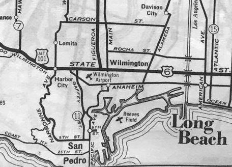
Los Angeles Harbor Airport / Wilmington Airport, Wilmington, CA
33.79, -118.29 (Southeast of Los Angeles International Airport, CA)
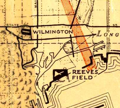
Wilmington Airport, as depicted on a 1938 street map (courtesy of Kevin Walsh).
According to Buzz Tupman, “Prior to WWII (1938-39) in L.A. Harbor a young pilot named Kenny Bates
was operating sightseeing rides in his J-3 Piper Cub on floats off the beach at Cabrillo.
My father, Thomas 'Hilton' Tupman, being a pilot, would often see the seaplane when leaving the harbor for family trips to Catalina.
He eventually introduced himself & Kenny proposed an idea to my Dad to acquire an piece of land
and build a small seaplane-accessible airport at the top of what was once called the Bixby Slough.
The property, located at Pacific Coast Highway & Figueroa, was the beginning of Los Angeles Harbor Airport.”
The earliest depiction which has been located of Wilmington Airport was on a 1938 street map (courtesy of Kevin Walsh).
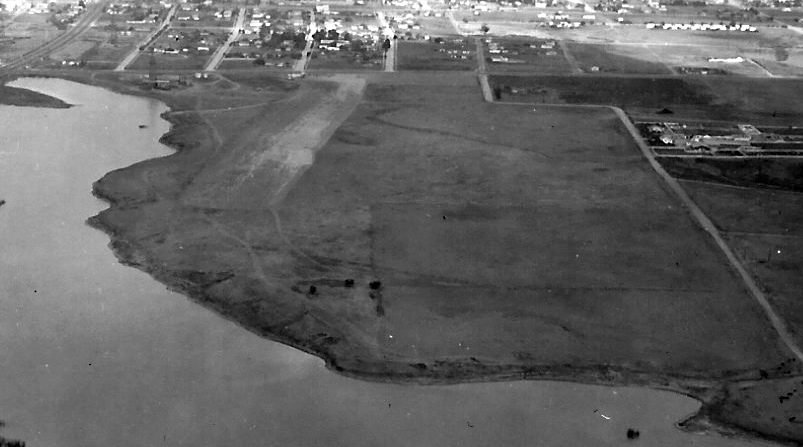
A circa 1938-41 aerial view of Bixby Slough (courtesy of Buzz Tupman), showing the location of Los Angeles Harbor Airport.
Buzz observed, “Pacific Coast Highway in the left lower corner, and Figueroa on the left upper corner.
I believe the airport was located to the top right of the slough.”
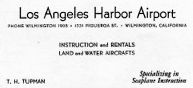
A circa 1938-41 business card for T.H. Tupman of Los Angeles Harbor Airport (courtesy of Buzz Tupman),
describing “Instruction & rentals” of “land & water aircraft”, “Specializing in seaplane instruction.”
According to Buzz Tupman, “Their aircraft inventory included: 1 J-3 Piper Cub on wheels, 2 J-3 Pipers on floats,
1 Taylorcraft on floats, 3 Interstate Cadets on wheels, and 1 Piper Cruiser.
The airport operated a flight school & rental business for both land and water aircraft, as well as tie-down space for a dozen or so aircraft.
My jobs even at that young age were hauling fuel to the seaplanes & dragging the tie-down to keep it free of weeds.”
Apparently Los Angeles Harbor Airport was also known as Wilmington Airport,
as that is how it was labeled on the 1939 LA Sectional Chart.
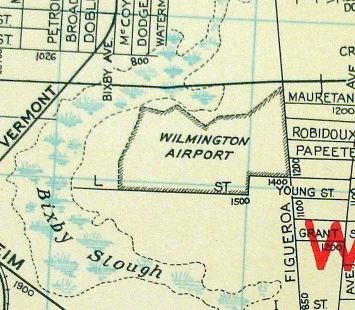
A 1940s street map depicted Wilmington Airport as an irregularly-shaped property outline in between Bixby Slough & Figueroa.
The last depiction which has been located of Wilmington Airport was on the October 1941 LA Sectional Chart,
which depicted Wilmington as a commercial/municipal airport.
According to Buzz Tupman, “The field was in operation for approximately 4 years until the war broke out at which time the field was closed
and the aircraft were shipped out to the high desert for military contract training.
The airport was abandoned.”
The 1944 LA Sectional Chart no longer depicted any airport in Wilmington.
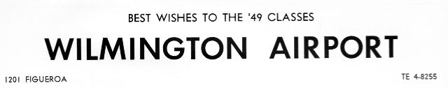
Wilmington Airport evidently reopened after WW2,
as it was an advertiser in the 1949 Banning High School Yearbook (courtesy of Chris Rubacha).
According to Buzz Tupman, on the site of Wilmington Airport, “eventually a school & a golf course were built after the war.”
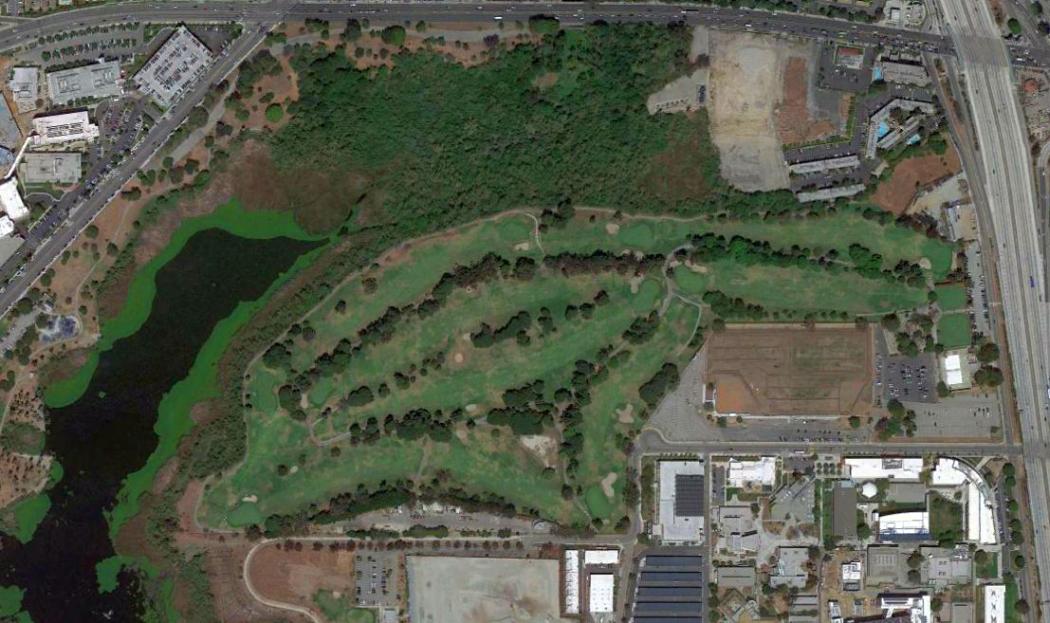
A 2013 aerial photo shows no trace of the former Los Angeles Harbor Airport.
Recent street maps label the site of Bixby Slough as Machado Lake, and the site of Los Angeles Harbor Airport as Harbor Park Golf Course.
Thanks to Buzz Tupman for pointing out this airfield.
____________________________________________________
Torrance Field / North Torrance Airport / Torrance Community Airport /
Bay Cities Airport, Torrance, CA
33.875, -118.35 (Southeast of Los Angeles International Airport, CA)
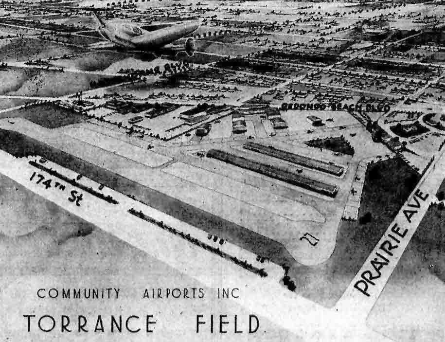
An artist's conception of Torrance Field from the 5/30/46 Torrance Herald (courtesy of John King).
According to “The History of the 'First' Torrance Airport(s)” by Jim Osborne,
“On April 5, 1946 a meeting was held at the Lawndale Civic Center & conducted by the Lawndale Civic Association
that would address the proposal brought forth by Ray Walker of Community Airports Inc.
for a 'Flying Field' to be located at the west end of the former McDonald Tract.
Representatives from the City of Torrance Planning Commission were on hand to discuss the issue.
The roughly 40-acre site was also under consideration for a newly-proposed college
prior to the selection of the eventual site just west of Alondra Park.
The creation of the new airport succeeded.”
Jim continued, “The new airport was originally named Torrance Field after plans were first drawn in early 1946,
but by April of the same year it became commonly known as the North Torrance Airport.”
The earliest depiction of Torrance Field which has been located
was an artist's conception of “Community Airports Inc. Torrance Field”
from an article entitled “North Torrance Airport to be placed in operation for small planes June 1”
from the 5/30/46 Torrance Herald (courtesy of John King).
The caption read, “North Torrance Airport opening set.
June 1 will see the new Torrance Airport of Community Airports Inc., headed by Col. W.J. Fox, opened for operations.
Above is an artist's conception of the completed airport as proposed.
Two 2,300' runways & taxiways already are paved.
Parkways for automobiles are being provided, as shown in the drawing,
along 174th Street & at the intersection of Redondo Beach Boulevard & Prairie Avenue.
The huge $20,000 hangar already is under construction,
and future development which will total $500,000 will call for display & sales rooms,
gasoline pits for servicing planes, wash ramps, and plane parking (tiedown) areas as indicated.
Only light private planes will be allowed on the airport except in emergency,
thus eliminating objectionable noise, it was said.”
According to Jim Osborne, “Despite some protests by nearby residents in Lawndale & Redondo Beach, the new airport opened on June 1, 1946
and was headed by Marine Col. William Fox who claimed it was to be the 1st in a chain of such community airports
and that it would also be 10 years ahead of its time in 'airdrome engineering'.
Fox further stated that only basic & advanced trainer planes known as BTs & ATs would be allowed to fly at the Torrance Field,
and that 'nosiy Army & Navy trainers would have no place on the private field'
in an obvious attempt to pacify worried homeowners.”
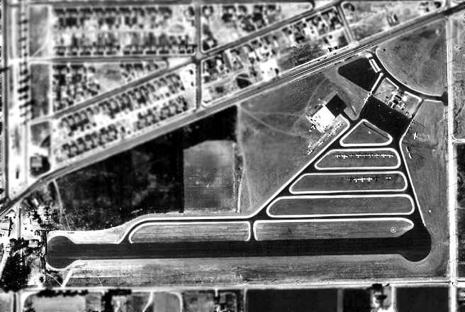
The earliest photo of North Torrance Airport which has been located was a 9/4/46 aerial view (courtesy of Jim Osborne).
It depicted North Torrance Airport as having a single 2,700' asphalt east/west runway along the south side of the property,
along with paved taxiways, several ramps, and a hangar on the northeast side.
Two dozen aircraft were visible on the field.
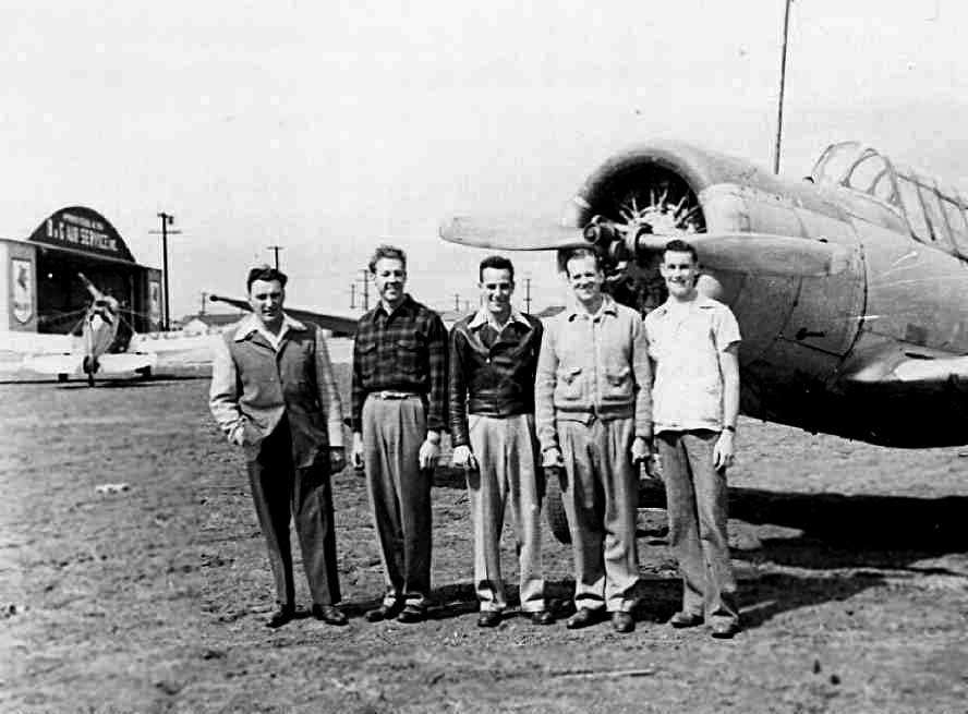
According to Jim Osborne, “A flight school known as B&G Air Service was operated at the new airport by Clifford Bantel
who trained students using Aeronca Champion 7-AC aircraft.
In an early attempt to drum up business, Bantel conducted a contest
that offered over '500 prizes of flying lessons' using the airplanes his company sold.”
Bill Switzer, a graduate of B&G recalled the airport having “2 or 3 tin hangars & a building that housed Mr. Bantel's office,
plus a small restaurant that was more like a lunch counter.
The runway departure flight path crossed over the Flying Fryers Ranch which was a turkey ranch at the west end of the airport.
The birds were frequently scared by low-flying aircraft.
There were also telephone wires at the east end that usually required slips to a landing.”
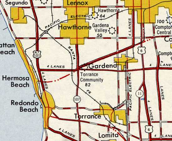
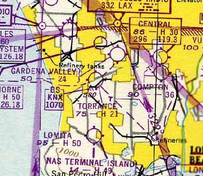
The 1946 USGS map depicted the field as Torrance Community Airport.
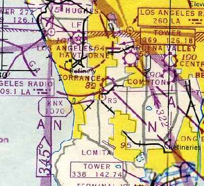
The earliest aeronautical chart depiction which has been located of the Torrance Airport
was on the February 1947 LA Sectional Chart (courtesy of Chris Kennedy).
It depicted Torrance as a commercial/municipal airport.
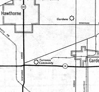
A 1947 USGS map depicted the Torrance Community Airport.
According to Jim Osborne, “Later it was also simply known as the Torrance Airport or the Torrance Community Airport
before finally being named the Bay Cities Airport in 1948.”
A circa 1948 photo of Bay Cities Airport (courtesy of Dave Pierson via Jim Osborne).
Standing in front of a Vultee BT-13 are Frank Shatz, Dave Pierson, Bert Bender, Jack Locke, Norm Peterson.
In the background at left can be seen the hangar of B&G Air Service.
Former Lawndale resident Richard Meyer also recalled the airport.
“When we were kids we would walk over to the airstrip that was just across the street from Royer's Red Barn Tavern
that was located on the northeast corner of Hawthorne Boulevard & Redondo Beach Boulevard.
The owners of the planes would tell us kids that they would pay us to wash the planes.
It seemed like such a smart way to keep the kids from vandalizing the planes.”
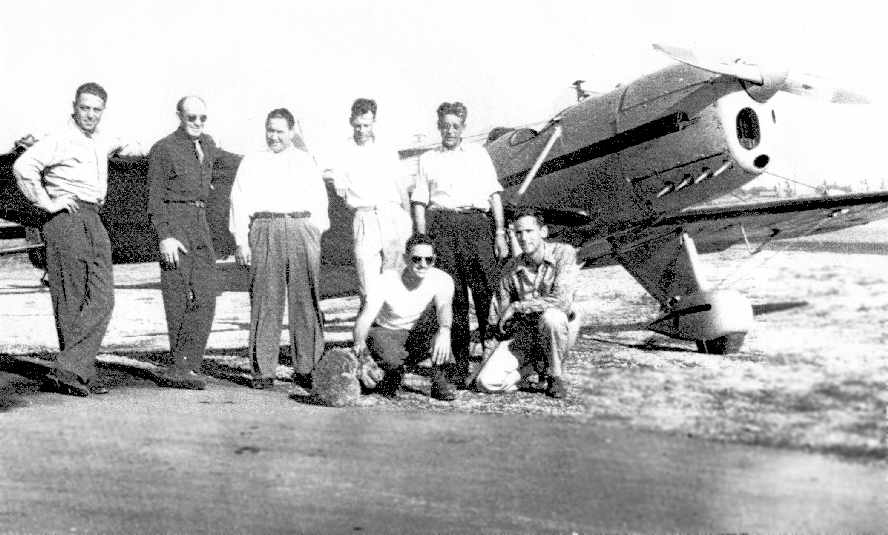
An undated (circa late 1940s?) photo of Bay Cities Airport (courtesy of Chuck Livergood via Jim Osborne).
Standing beside the 1935 Ryan S.T.A. airplane with a Monasko engine are: Jack Roberts (owner of Sky Store at Vail Field in Los Angeles),
Ray Wolsky (co-owner of Bay Cities shop), and 3 unidentified men.
Kneeling are: Ed Williams, and Chuck Livergood (co-owner of Bay Cities shop).
Roger Keeney, owner of Acme Aircraft, recalled, “I remember Bay Cities well.
There were a lot of tall trees at the west end of that runway that you had to watch out for while you were taking off.”
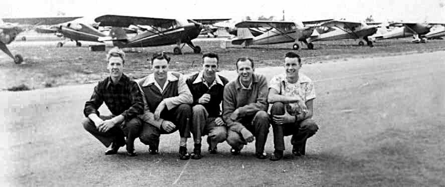
A circa 1948 photo of Bay Cities Airport (courtesy of Jim Osborne).
Gathered in front of the aircraft are Dave Pierson, Frank Shatz, Bert Bender, Jack Locke, Norm Peterson.
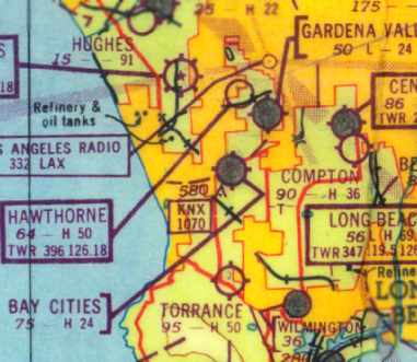
The last aeronautical chart depiction which has been located of the Torrance / Bay Cities Airport
was on the February 1949 LA Sectional Chart (courtesy of Chris Kennedy).
It depicted Torrance as having a 2,100' paved runway.
Chuck Liverwood & his partner Ray Wolsky operated an aircraft & engine shop about 1950 at Bay Cities.
A February 1950 map published by General Petroleum (which later became Mobil Oil)
depicted Bay Cities Airport as having a 2,400' paved runway.
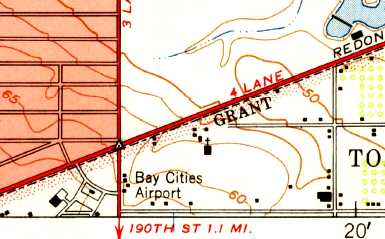
The 1950 USGS topo map depicted Bay Cities Airport as an open area with several buildings along the west & south sides.
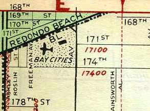
A 1951 street map (courtesy of Chris Kennedy) depicted Bay Cities Airport
as being located southeast of the intersection of Redondo Beach Boulevard & Freeman Avenue.
It depicted a single building on the northeast corner of the property.
Bay Cities Airport was evidently closed by 1951,
as it was no longer depicted on the March 1951 San Diego Sectional Chart (according to Chris Kennedy).
Jim Osborne continued, “Sadly, the Bay Cities Airport proved to be short-lived.
In all, it operated less than 5 years.
For a short time after its closing, some former residents recall seeing teenagers
using the long runway as a drag strip to race their hot rods.
Another Torrance pilot, Gene Duport once raced his own hotrod around the South Bay
and remembers a fatal crash that resulted in the shutting down of the racing at the former airport by the local authorities.
By 1951, new home construction had begun on the former airstrip land.
And coincidentally, Mr. Duport worked as a journeyman who installed wiring in the newly constructed homes.”
A 1952 aerial photo showed that houses & streets had covered the site,
with not a trace remaining of the former Bay Cities Airport.
Chuck Liverwood recalled that “After Bay Cities closed there was still a lumber yard on Redondo Beach Boulevard called Airport Lumber,
and people were always confused as to how the lumber yard got its name because it was so far from the Los Angeles Airport.
They didn't realize the location once served as an airport.”
The 2004 USGS aerial photo shows that the site of Bay Cities Airport has been densely developed,
with not a trace appearing to remain of the former airport.
Jim Osborne reported in May 2007, “Today this same location,
which now contains over 200 homes & also several businesses at its west end & at its northwest corner,
and which is partially bisected by the San Diego Freeway,
is still referred to by a few current & former residents as the 'Airport Tract' of Torrance.”
The site of Bay Cities Airport is located southeast of the intersection of Redondo Beach Boulevard & Freeman Avenue.
Thanks to Jim Osborne for pointing out this airfield.
____________________________________________________
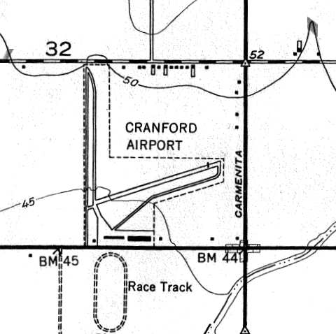
Artesia Airport / Cranford Airport, Cerritos, CA
33.862, -118.052 (Northeast of Long Beach, CA)
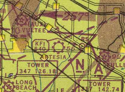
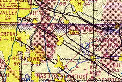
Artesia Airport, as depicted on the February 1946 San Diego Sectional Chart (courtesy of Chris Kennedy).
This small general aviation airport was evidently built at some point in 1945,
as it was not yet depicted at all on the August 1945 San Diego Sectional Chart (according to Chris Kennedy).
The earliest depiction of the field which has been located
was on the February 1946 San Diego Sectional Chart (courtesy of Chris Kennedy).
It depicted Artesia Airport as a commercial or municipal field.
The June 1946 Department of Commerce Airman's Guide (according to Chris Kennedy)
described “Artesia Airport” as being renamed “Cranford Airport”, as of June 18, 1946.
Cranford Airport, as depicted on the 1946 USGS topo map.
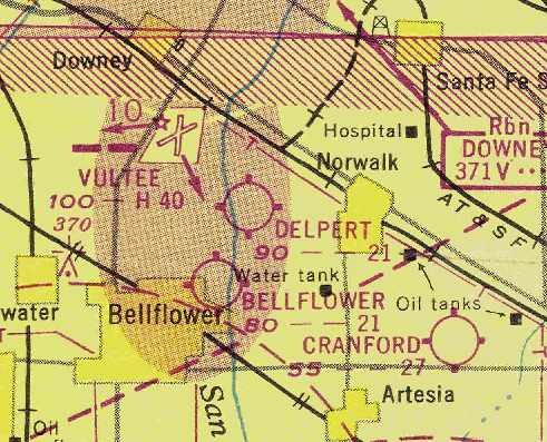
The September 1948 San Diego Local Aeronautical Chart (courtesy of Chris Kennedy)
described Cranford Airport as having a 2,700' unpaved runway.
The 1949 USGS topo map (courtesy of Francis Blake)
depicted Cranford as consisting of two 2,300' runways,
one oriented north/south & the other northeast/southwest.
Each runway had a parallel taxiway,
and a ramp along the south side of the field had 2 buildings (hangars?).
The 1949 San Diego Sectional Chart (according to Chris Kennedy)
described Cranford Airport as having a 2,700' unpaved runway.
Bill Alley recalled, "My grandfather owned a lumber yard in nearby Downey
and his wife [Fanny Alley] purchased the Cranford airport sometime in the years following WW2 as a real estate investment."
The earliest depiction which has been located of Cranford Airport
was an undated aerial view looking north from the 1950 Air Photo Guide (courtesy of Kevin Walsh).
The guide described Cranford Airport as having a 2,500' paved northeast/southwest runway & a 2,500' dirt north/south runway.
It listed the manager as George Owens.
Cranford Airport evidently gained a paved runway at some point between 1949-51,
as the March 1951 San Diego Sectional Chart (courtesy of Chris Kennedy)
depicted Cranford as having a 2,200' hard surface runway.
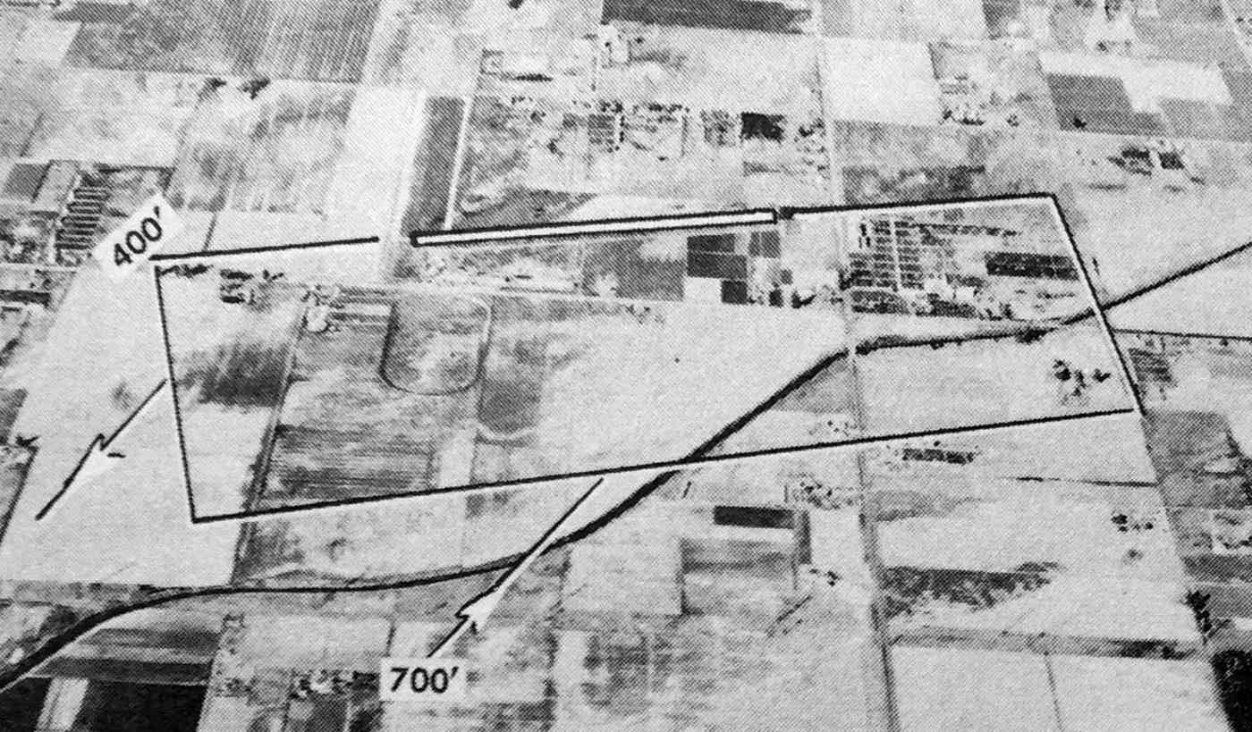
A 1952 aerial view depicted Cranford Airport as having 2 runways, one oriented north/south & the other northeast/southwest.
Each runway had a parallel taxiway, and a ramp along the south side of the field had 2 hangars.
A dozen light aircraft were parked on the southwest side of the field.
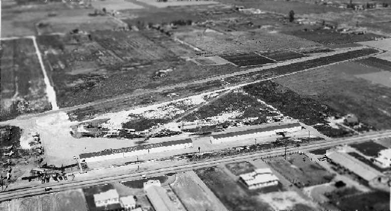
An early 1953 aerial view looking north at Cranford Airport (Bill Alley)
depicted the field as having a paved east/west runway, along with an unpaved north/south strip.
Two hangars were on the south side of the field (one of which had "Cranford Airport" painted on the roof),
and a number of small aircraft were visible on the southwest corner of the field.
A later 1953 aerial view was in start contrast to the earlier photos – with only a single airplane visible on the field.
Cranford Airport apparently closed at some point between 1953-54,
as it was no longer depicted on the September 1954 San Diego Sectional Chart (courtesy of Chris Kennedy).
It was evidently a very short-lived airfield, only lasting no more than 9 years.
Cranford Airport was not depicted at all on the 1964 USGS topo map.
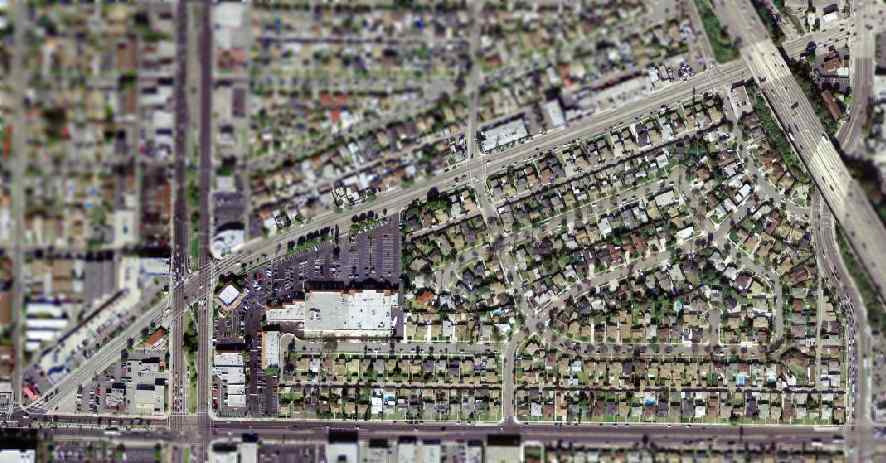
A 1972 aerial view showed no trace of the airport, with dense housing having covered the site.
In the March 2004 USGS aerial photo of the site of Cranford Airport,
incredibly, even though the area has been densely developed,
the former northeast/southwest runway appears to have remained intact.
The former runway is still quite recognizable in the photo -
it forms the north edge of the parking lot of the retail shopping complex
which has been built along the southern portion of the former airport site.
The site of Cranford Airport is located on the northwest corner
of the intersection of Orangethorpe Avenue & Carmentia Avenue.
Thanks to Francis Blake for pointing out this airfield.
____________________________________________________
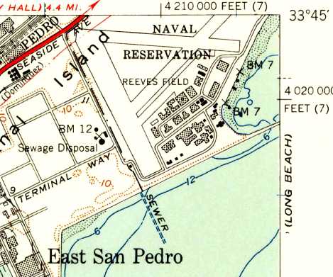
Allen Field / San Pedro NAS / Reeves Field, Long Beach, CA
33.75, -118.257 (Southeast of Long Beach, CA)
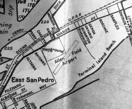
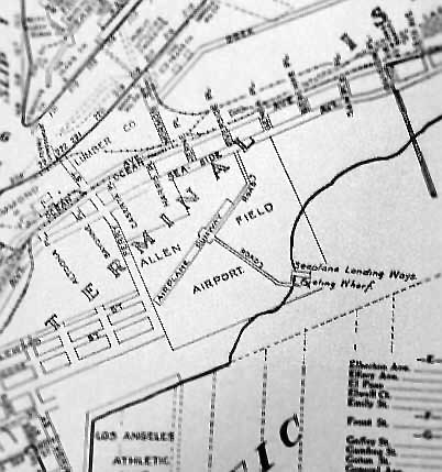
“Allen Field Terminal Island Airport” as depicted on a circa 1927-28 Security Bank map (courtesy of Kevin Walsh).
This former military airfield was located on Terminal Island, a sand-filled island in Long Beach Harbor.
The airfield was adjacent to the former Long Beach Naval Station.
According to Richard Landgraff (who worked at the Long Beach Naval Shipyard for 39 years
& recently wrote a book about the shipyard),
a civilian airfield, Allen Field, was first established on this site in 1927.
The Naval Reserve established a training center at the San Pedro airfield in 1927.
The earliest depiction which has been located of Allen Field was on a circa 1927-28 Security Bank map (courtesy of Kevin Walsh).
It depicted “Allen Field Terminal Island Airport” as a small square property outline (much smaller than the airfield's eventual size)
within which was a small northeast/southwest runway, and a taxiway leading toward the southeast.

The earliest aeronautical chart depiction which has been located of Allen Field
was on the 1929 LA – Las Vegas Air Navigation Map #132.
The Standard Oil Company's 1929 "Airplane Landing Fields of the Pacific West" (courtesy of Chris Kennedy)
described San Pedro Municipal Airport, "Allen Field", as having a 2,000' northeast/southwest oiled clay runway,
and a 200' seaplane launch way.
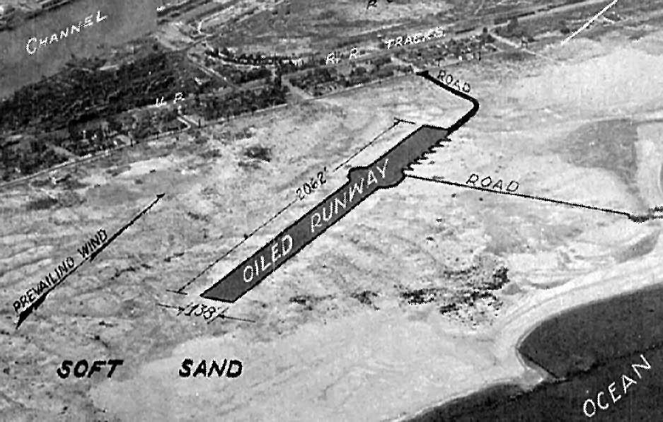
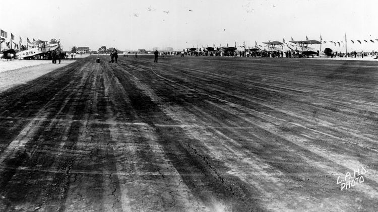
The earliest photo which has been located of Allen Field was an undated aerial view looking north
from the Richfield Oil Company's 1929 "California Airports" directory (courtesy of Jonathan Westerling).
It described "Allen Field" as having a single 2,062' northeast/southwest oiled runway,
but not having any other facilities.
“Allen Field Airport” as depicted on a 1932 map (courtesy of Kevin Walsh).
Allen Field was depicted as an auxiliary airfield on the 1934 San Diego Airway Chart (courtesy of Roger Connor).
“Allen Field Airport” was depicted on a 1935 Security Bank map (courtesy of Kevin Walsh) as having a northeast/southwest runway.
The Naval Reserve took complete control of Allen Field in 1935.
In 1936 the field was designated Naval Air Base San Pedro, Reeves Field.
The Airport Directory Company's 1937 Airports Directory (courtesy of Bob Rambo)
described Reeves-Navy airfield as having a single 2,000' oiled runway.
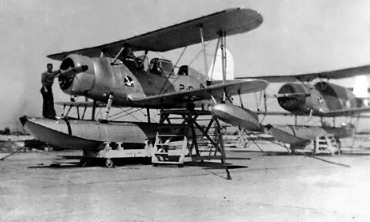
A 1938 U.S. Navy photo of SOC-3 Seagull floatplanes of Observation Squadron Two parked at Reeves Field.
The 1939 LA County Airports Map depicted Reeves Field as having 3 runways.
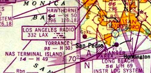
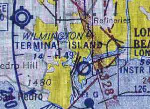
San Pedro NAS, as depicted on the 1941 LA Sectional Chart (courtesy of Chris Kennedy).
Frank Harris recalled, “P-38's... were at Reeves Field on Terminal Island & were in concrete bunkers with high walls.
There were a lot of PBY Catalinas there with red stars on them
and also P-39 Aircobras with Russian markings, but that was later on after the war started.”
A circa 1940s Thomas Brothers map (courtesy of Rex Ricks)
depicted the “Allen Field Airport” as having a single northeast/southwest runway,
with a road loading toward “Seaplane Landing Ways” on the southeast side of the field.
It was redesignated Naval Air Base Terminal Island is 1942.
The San Pedro airfield eventually consisted of 3 paved runways (the largest was 4,200' long),
a large seaplane ramp, and several hangars & other buildings.
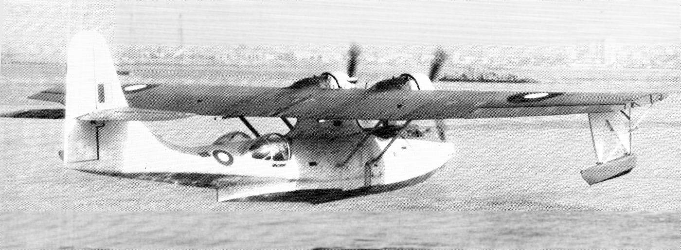
A rare 1945 U.S. Navy photo of a factory-fresh Boeing-built PB2B-2 Catalina landing in Long Beach Harbor at NAS San Pedro (courtesy of John Voss).
John Voss noted, “It was built of the Royal Australian Air Force. Boeing finished the aircraft in standard RAF Coastal Command colours with the RAF S/N of JX661.
It was eventually assigned the RAAF S/N of A24-350 & would be entirely repainted in O/A black for the 'Black Cat' operations.
The [original] caption on the photo states that there was a RAAF Acceptance & Ferry Detachment at NAS San Pedro.”
Originally, San Pedro's primary function was to serve as a base
for seaplanes assigned to ships of the Pacific Fleet.
During WW2, it was used to equip & perform flight tests on a large number
of aircraft produced at the nearby plants of Lockheed, Douglas & Vultee.
"NAS Terminal Island" was described by the 1944 US Army/Navy Directory of Airfields (courtesy of Ken Mercer)
as having a 4,900' hard-surface runway.
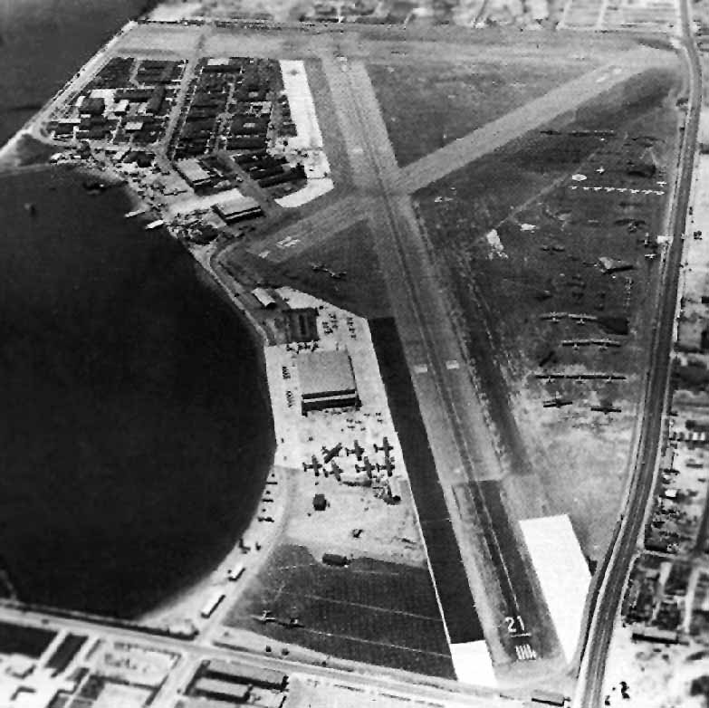
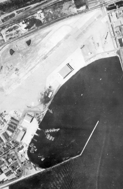
A 1945 aerial view looking southwest at NAS Terminal Island (National Archives photo).
A circa 1945 U.S. Navy photo (courtesy of John Voss) of NAS Terminal Island (Reeves Field),
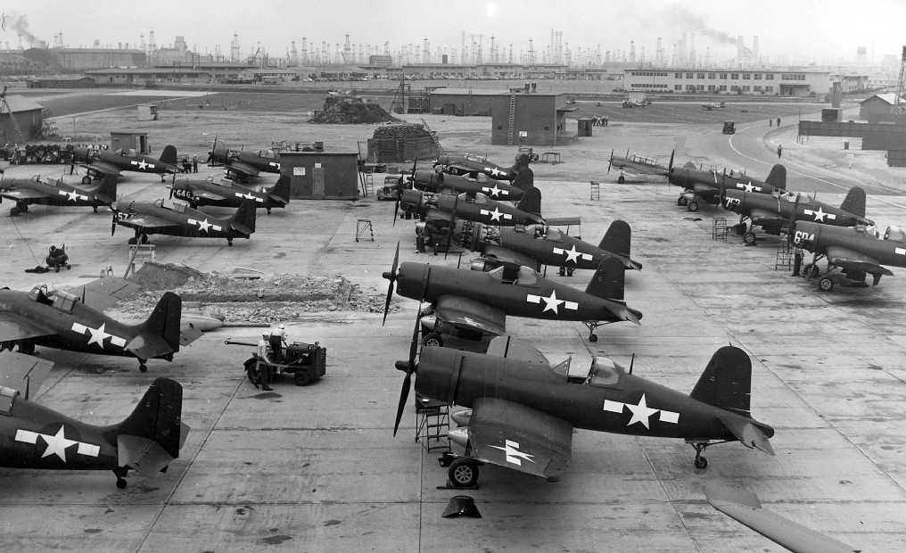
showing a number of ‘factory fresh” FM-2 Wildcats, F4U Corsairs and one tri-colored Curtiss SNC.
The 1945 AAF Airfield Directory (courtesy of Scott Murdock) described Terminal Island NAS
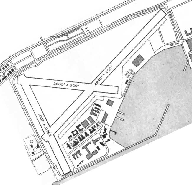
as a 334 acre rectangular property within which were 3 asphaltic concrete runways, the longest being the 4,940' northeast/southwest strip.
The field was said to have 2 metal hangars, measuring 260' x 80' & 150' x 130',
to be owned by the City of Los Angeles, and operated by the Navy.
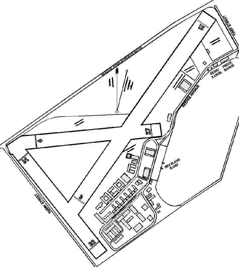
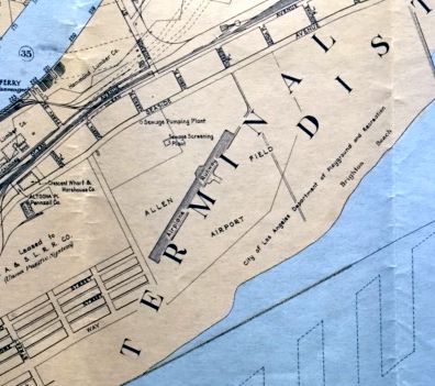
A map of Reeves Field by Richard Landgraff, author of a book on the history of Long Beach Naval Shipyard.
A 1947 aerial view looking northeast at Reeves Field, showing 3 paved runways & a hangar.
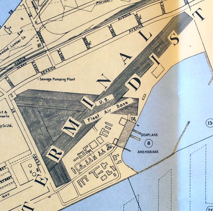
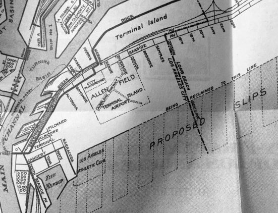
A July 1947 Board of Harbor Commissioners map of the Terminal Island “U.S. Fleet Air Base” (courtesy of Kevin Walsh)
depicted 3 runways, buildings, and the seaplane anchorage.
The 1947 Mojave Desert World Aeronautical Chart depicted NAS Terminal Island as having a 4,900' hard surface runway.
The Naval Air Station at Terminal Island was disestablished in 1947,
with the airfield continuing in operation is a reduced status.
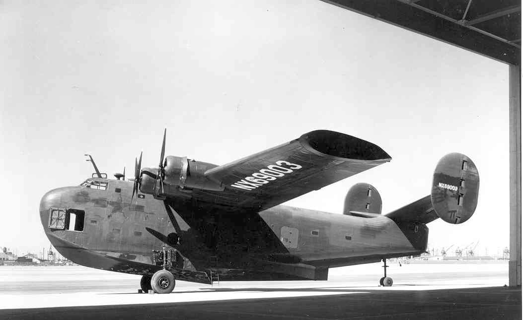
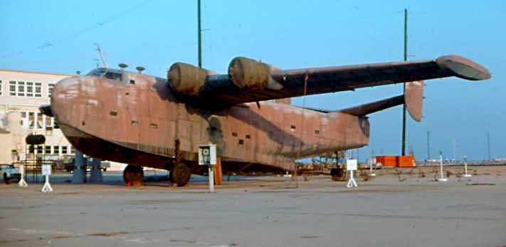
A circa late 1940s photo of a rare Consolidated PB2Y-5R Coronado in civilian markings, owned by Hughes Aircraft, evidently taken at Reeves Field.
This aircraft, BuNo 7099, was stricken from the Navy inventory in August 1946 & then by Howard Hughes.
He bought it to gain experience piloting a large flying boat, prior to his first flight of the massive Hughes HK-1 Hercules.
According to the book “Howard Hughes Aviator”, Hughes “never flew the PB2Y-5R,
and for the next 27 years the aircraft's home was in Long Beach.”
NAS Terminal Island was depicted as an active airfield on the 1949 San Diego Sectional Chart (according to Chris Kennedy).
The 1951 USGS topo map depicted Reeves Field as having 3 paved runways.
The Terminal Island airfield was depicted on the March 1951 San Diego USAF Sectional Chart(according to Chris Kennedy),
but the Aerodromes table described the field as "Closed".
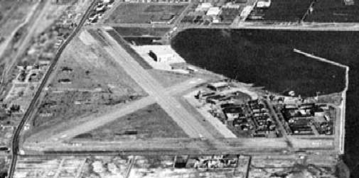
The last photo which has been located showing the runways of Reeves Field remaining intact was a 1952 aerial view.
The field consisted of 3 paved runways, with several hangars & other buildings along the south side.
No aircraft were visible on the property.
"Terminal Island" was still depicted on the September 1954 USAF LA Sectional Chart (courtesy of Chris Kennedy),
and described as having a 4,900' hard surface runway.
"Terminal Island" was still depicted on the 1955 San Diego Sectional Aeronautical Chart (courtesy of John Voss),
but the Aerodromes table described the field as "Navy. Closed. Inactive."
The airfield was described as consisting of a 3 bituminous runways (the longest being 4,940').
By the time of the 1960 LA Local Area aeronautical chart, Terminal Island was labeled as "Abandoned airport".
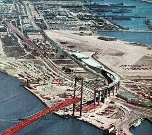
A 1963 aerial view looking south at the Vincent Thomas bridge under construction, with Reeves Field visible in the background (courtesy of Kevin Walsh).
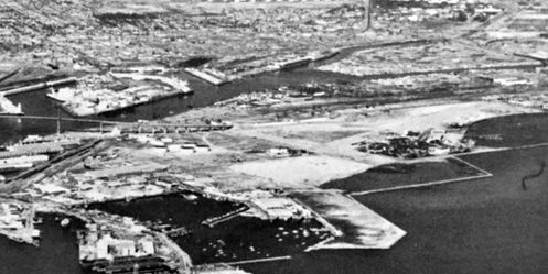
An undated aerial view looking north at Reeves Field from the March 1966 Southern CA Traveler (courtesy of Kevin Walsh).
A 1969 aerial view looking southwest (courtesy of John King) showed Catalina Island showed Reeves Field as abandoned,
but the majority of the runways, hangars, and other airfield facilities remained intact.
According to Richard Landgraff, the airfield property was given back to the city of LA in 1971
and was used for some time afterward to store imported automobiles.
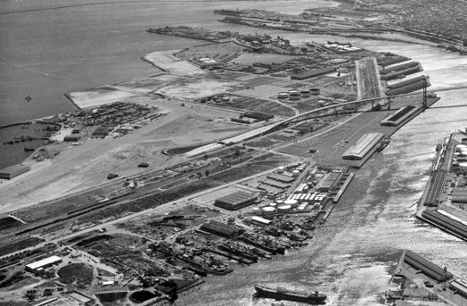
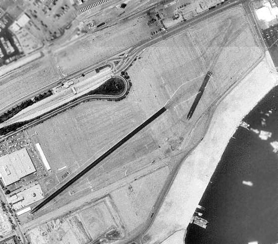
A 5/26/72 aerial view showed that 2 large buildings had been built over the northwest corner of the runways,
but the majority of the runways, hangars, and other airfield facilities remained intact.
According to Alex Calder, the Terminal Island airfield “was home to the Brotherhood Raceway,
a local strip where street folks could come down & race in a legal, non-dangerous way.
I used to shoot video down there for a friend."
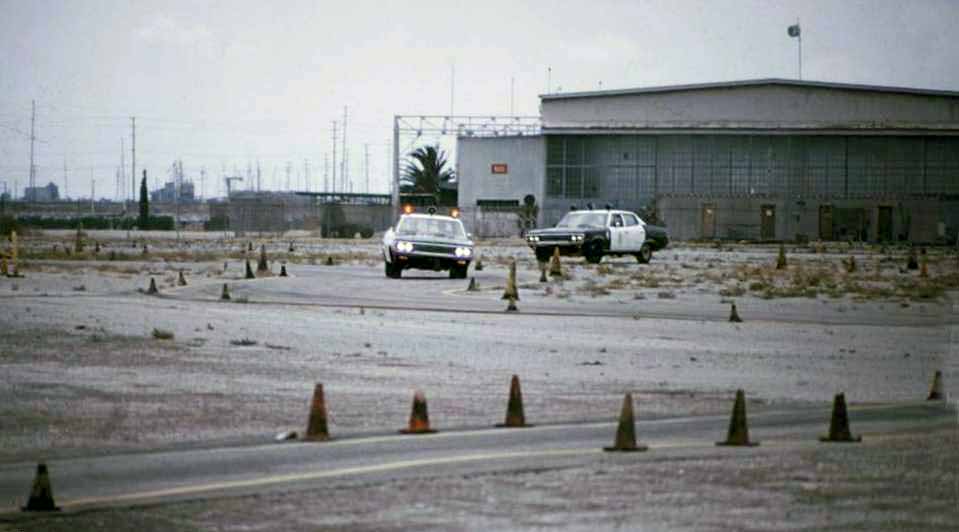
A 1974 photo by Eric Birkeland “of Terminal Island in 1974.
At that time it was being utilized as LAPD’s pursuit driver training facility.”

A June 1975 photo by Mark Morgan of the Consolidated PB2Y-3 sitting alone on the Reeves Field ramp.
Mark recalled, “I did 1st Class Cruise (summer 1975) out of NAVSTA Long Beach.
One day I saw some hangars & an expanse of pavement, 'Hmmm, wonder what that is?'
I meandered on over with my camera, stumbled across this HUGE flying boat, 4 engines, really bad shape, didn't have a clue what it was.
I learned later it was the last surviving PB2Y, BuNo 7099, formerly owned by Howard Hughes.”
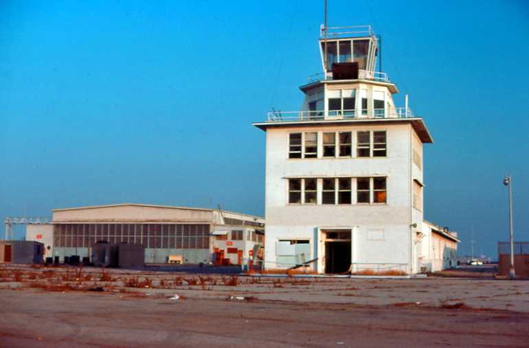
A circa 1975-76 photo by Jim Babin of the San Pedro control tower & a hangar.
Jim observed, “The tower was still in pretty good shape, and appeared to be an excellent example of a 1930s/40s structure.”
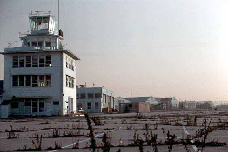
A circa 1975-76 photo by Jim Babin of the San Pedro control tower & several hangars.
A circa 1975-76 photo by Jim Babin of the San Pedro ramp,
with a sole aircraft still present, a rare Consolidated PB2Y Coronado flying boat.
A circa 1975-76 photo by Jim Babin of Consolidated PB2Y Coronado flying boat on the San Pedro ramp.
Jim recalled, “There wasn’t anybody around to provide any info on the PB2Y Coronado,
but I suspect it might be the same aircraft that the National Naval Aviation Museum in Pensacola had in the 1980s (they may still have it).”
John Snapp recalled, “The Brotherhood Raceway Park actually opened in December 1976.
I used to run my Camaro there.
It was run & operated by Big Willie & the Brotherhood of Street Racers.”
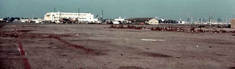
A 1980 aerial view showed that 3 large hangars still remained standing on the south side of the former Terminal Island airfield.
A large number of smaller airfield buildings had been removed between 1972-80,
and a majority of the runways had been covered by other construction.
John Snapp recalled, “The Brotherhood Raceway Park... A CHiPS episode was filmed there about 1980.”
A circa 1983 aerial view of Reeves Field (courtesy of Kevin Walsh) showed 2 closed-runway “X” symbols painted on remaining runway segments,
and what appears to be the Consolidated PB2Y Coronado flying boat still parked next to the hangars.
John Snapp recalled, “It was used for drag-racing until 1984.
Due to disputes with the property owner they never had a regular schedule,
they were only allowed so many race dates per year.
Between 1984-93 it was never used for racing.
It became a full-time track in late 1993 & closed for good in April 1995.”
In the 1994 USGS aerial photo, the asphalt strips that look like runways were built for vehicle testing by UCLA & police training, not for aircraft.
Landgraff notes, "If you look closely at the northeast end, you can see a discoloration of the ground that was the original Runway 21.
To the right is the new Naval Reserve Center which now sits over the very end of the original runway."
The former hangars had also been removed at some point between 1980-94.
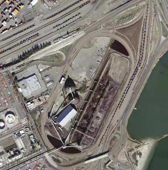
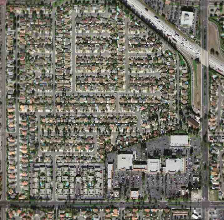
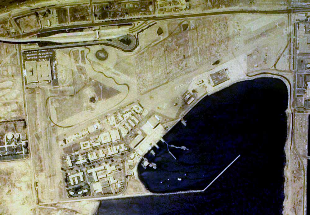
As seen in the March 2004 USGS aerial photo, a large industrial facility now covers the site of Reeves Field.
The only trace which appears to remain of the Naval Air Station is a single seaplane ramp leading down into the water.
____________________________________________________
Since this site was first put on the web in 1999, its popularity has grown tremendously.
That has caused it to often exceed bandwidth limitations
set by the company which I pay to host it on the web.
If the total quantity of material on this site is to continue to grow,
it will require ever-increasing funding to pay its expenses.
Therefore, I request financial contributions from site visitors,
to help defray the increasing costs of the site
and ensure that it continues to be available & to grow.
What would you pay for a good aviation magazine, or a good aviation book?
Please consider a donation of an equivalent amount, at the least.
This site is not supported by commercial advertising –
it is purely supported by donations.
If you enjoy the site, and would like to make a financial contribution,
you
may use a credit card via
![]() ,
using one of 2 methods:
,
using one of 2 methods:
To make a one-time donation of an amount of your choice:
Or you can sign up for a $10 monthly subscription to help support the site on an ongoing basis:
Or if you prefer to contact me directly concerning a contribution (for a mailing address to send a check),
please contact me at: paulandterryfreeman@gmail.com
If you enjoy this web site, please support it with a financial contribution.
This site covers airfields in all 50 states.