
Abandoned & Little-Known Airfields:
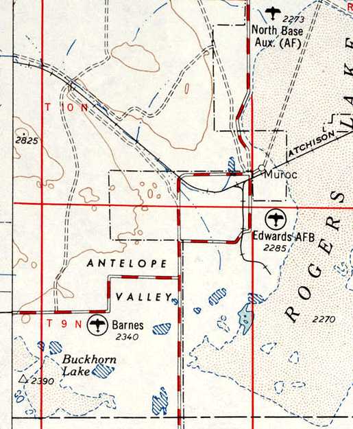
California - Northern Palmdale area
© 2002, © 2016 by Paul Freeman. Revised 11/14/16.
This site covers airfields in all 50 states: Click here for the site's main menu.
____________________________________________________
Please consider a financial contribution to support the continued growth & operation of this site.
Antelope Valley Intermediate Field Site 5 / Site 5B (revised 9/17/16) - Bohunk's Airpark / Bohunk International Airport (added 10/24/16) - Hawes Aux AAF #1 (revised 11/14/16)
Helendale Aux AAF #2 / Helendale Airport (revised 12/23/14) - (Original) Lancaster Airport (revised 7/11/15) - Liberty Field (revised 11/11/14)
Pancho Barnes Airfield (revised 9/17/16) - Sky Castle Airport (revised 5/22/14) - War Eagle Field / Lancaster Airpark (revised 2/19/14) - Victory Field (revised 9/17/16)
____________________________________________________
Bohunk's Airpark / Bohunk International Airport (0CL6), Lancaster, CA
34.694, -118.28 (North of Palmdale, CA)
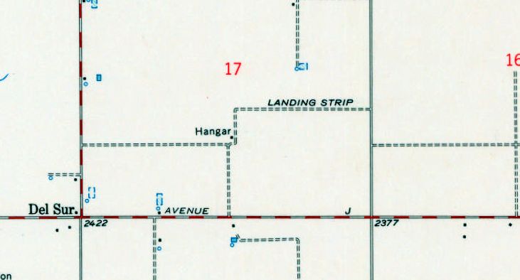
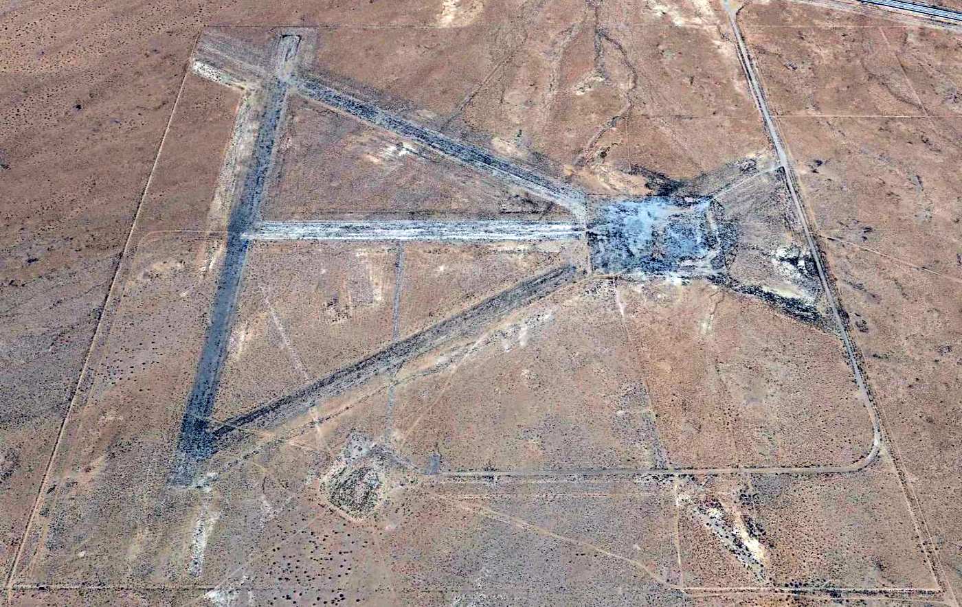
The 1958 USGS topo map depicted Bohunk's Airpark as an east/west unpaved runway labeled simply as “Landing Strip”.
The date of establishment of this small airfield in the California desert has not been determined.
The earliest depiction which has been located of Bohunk's Airpark was on the 1958 USGS topo map.
It depicted a single unpaved east/west runway, labeled simply as “Landing Strip”,
along with a hangar on the southwest side.
According to its FAA Airport/Facility Directory data, Bohunk's Airpark was activated in October 1987,
but that was evidently in its last incarnation, since it had been depicted on topo maps for nearly 30 years before that point.
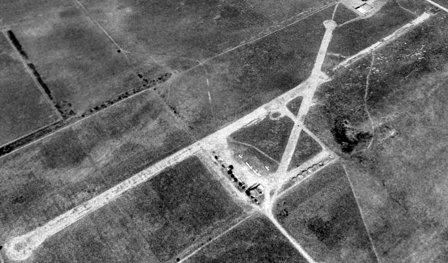
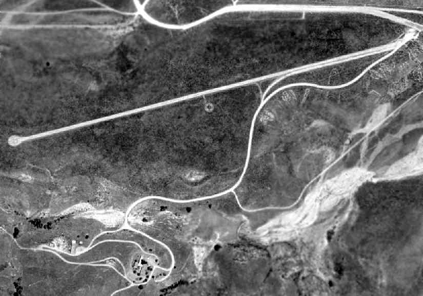
The earliest photo which has been located of Bohunk's Airpark was a 1994 USGS aerial view looking northeast.
It depicted Bohunk's as having 2 unpaved runways, with a cluster of T-hangars & at least 8 light single-engine aircraft on the south side.
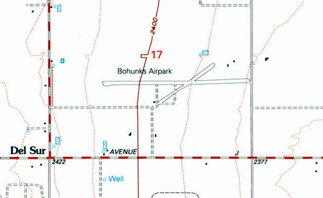
The earliest depiction which has been located which labeled Bohunk's Airpark by name was on the 1995 USGS topo map.
It depicted Bohunk's as having 2 runways, with one small building on the south side.

A 2015 aerial view looking northeast showed Bohunk's Airpark to have the same runway configuration as the earlier photo,
but many of the T-hangars had been removed at some point between 1994-2015, and the number of aircraft visible had decreased to only one.
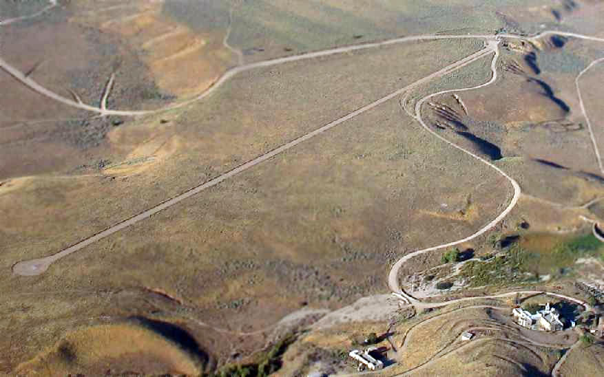
The 2016 Sectional chart depicted Bohunk's Airpark as a private field having a 1,900' unpaved runway.
As of 2016, the FAA Airport/Facility Directory described Bohunk's Airpark as a private airfield having a single 1,900' dirt Runway 9/27,
and it listed the owner as William Safranek.
It was said to have 21 aircraft based on the field: 20 single-engine aircraft & 1 helicopter.
But the remarks said “Land at own risk.”
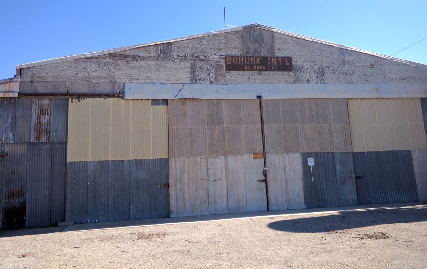
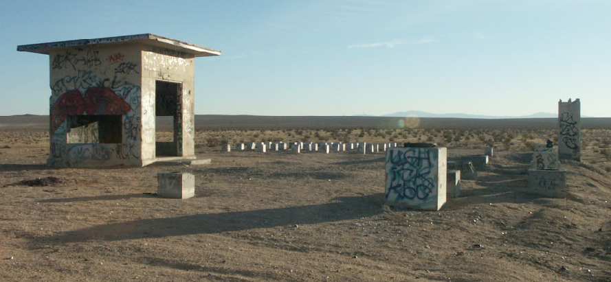
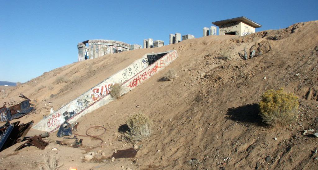
An 8/12/16 photo by Mike Delaney of the “Bohunk International” Airport hangar.
Mike reported, “The land is owned by a developer, who was surprised to find out they own an airport.
Looks like maybe a packed dirt runway, but it's in poor repair. No fences or signs of habitation, one hangar & some outbuildings.
The hangar looked like it was locked. The recreational vehicle that's parked on the site has tags that expired in 2010.”
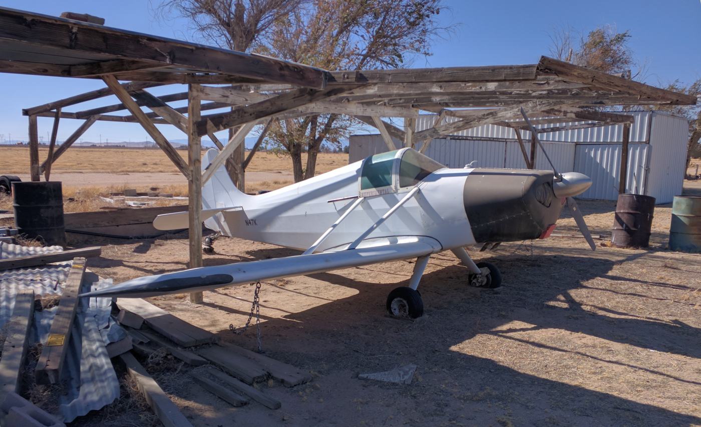
An 8/12/16 photo by Mike Delaney of N47K, a 1954 Stits Playboy SA3A at Bohunk's Airpark.
Mike reported, “The one airplane parked on the site has a valid registration but has flat tires, and looks like it has been parked on the site for a number of years.”
Bohunk's Airport is located northwest of the intersection of West Avenue J & 80th Street West.
Thanks to Mike Delaney for pointing out this airfield.
____________________________________________________
War Eagle Field / Lancaster Airpark, Lancaster, CA
34.7, -118.23 (Northwest of Palmdale, CA)

A 1941-42 photo of Wilfred Munsch & other cadets & instructors in front of a Stearman at War Eagle Field
(courtesy of Rick Munsch, whose father Wilfred was an RAF cadet at War Eagle).
War Eagle Field in Lancaster is not to be confused
with another airfield by the same name in Dos Palos, 175 miles to the northwest.
War Eagle Field was the site of a contract flying school, Polaris Flight Academy,
which was one of 4 schools operated by the Cal-Aero Flight Academy,
headquartered at Glendale's Grand Central Air Terminal.
The civilian schools were contracted by the US & foreign militaries to provide flight training for military cadets.
War Eagle Field opened in 1941.
It initially provided training to British & Canadian cadets.
Al Shaver recalled, “During 1941 & 1942 I was an instructor at War Eagle Field teaching RAF cadets.”

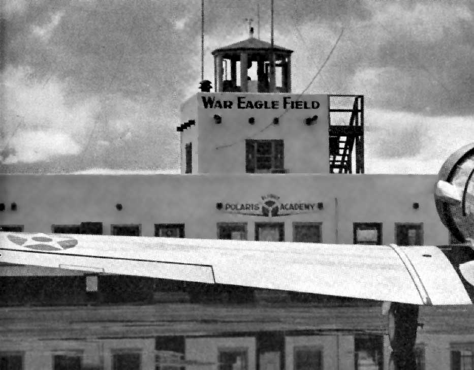
A 1941-42 aerial photo of Wilfred Munsch of buildings at War Eagle Field (courtesy of Rick Munsch).

A January 1942 aerial view looking south at War Eagle Field
(courtesy of Jeremy Davies, whose father attended training at the Polaris Flight Academy with the RAF).
In 1942, following the United States' entry into the war, it also began the training of USAAF cadets.
The War Eagle Flight Academy became at the time the only civilian school in the US to handle basic training of Army pilots.
Upon accepting the new role, construction commenced to double the size of the base.
The airfield at War Eagle Field was centered around 2 large hangars at the northwest end of the site.
A 2,400' long ramp just south of the hangars was oriented northeast/southwest,
and the two 2,400' runways extended to the east & south away from the ramp.
An undated view of the tower at War Eagle Field (courtesy of Dan MacPherson).
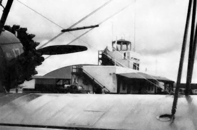
A 1942 view of the control tower through the wings of a Stearman trainer (courtesy of Dan MacPherson).
Every 4 & one-half weeks a new group of US pilots would arrive at Lancaster to commence their basic training.
After completing their course here, they were sent to Army Advance Training posts
where upon completion of their advance course they received their wings & commission.
The Vultee BT-13 was the predominant trainer aircraft used at War Eagle Field.

A WW2-era view of a hangar at War Eagle Field's Polaris Flight Academy.

A circa 1942 “Gold Star Merit Award” presented to RAF Cadet Wilfred Munsch
for having completed flight training without an accident at War Eagle Field (courtesy of Rick Munsch).
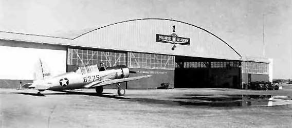
A WW2 era photo of a Vultee BT-13 in front of a Polaris Academy hangar at War Eagle Field.

A WW2 era photo of a cadets getting into a PT-17 at War Eagle Field (courtesy of John Voss).
John Voss observed, “It’s a PT-17 used by the RAF cadets with the fuselage code letter of 'BL' signifying British Lancaster.”

Vultee trainers on the flightline at War Eagle Field during WW2.
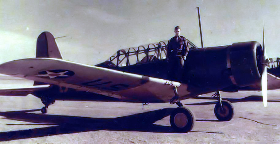
LT George Wood Mears, in front of a Vultee BT-13 at War Eagle Field during WW2.

A 1942 photo of War Eagle's Administration Building (courtesy of Dan MacPherson).
Bruce Stanton reported, “My father, Jay Stanton, was a Flight Instructor at the Polaris Flight Academy throughout most of WWII.”

A 7/22/43 aerial view looking west from the 1945 AAF Airfield Directory (courtesy of Scott Murdock)
depicted War Eagle Field as having 2 paved runways.
In 1944, the name of the Polaris Flight Academy was changed to Mira Loma Flight Academy.
The 1944 US Army/Navy Directory of Airfields (courtesy of Ken Mercer)
described "War Eagle, Army" as having a 3,100' runway.
Two smaller auxiliary landing fields were associated with War Eagle Field during WW2:
Liberty Field (located 8 miles northeast of War Eagle Field),
and Victory Field (located 6 miles northwest of War Eagle Field).
In an article in AOPA Pilot Magazine, Duane Cole described meeting famous test pilot Tony LeVier at War Eagle Field:
“I never had the opportunity to meet him until 1942, at War Eagle Field, where I was instructing military cadets.
By that time I knew he had gone to work for the Lockheed Aircraft Company,
and I'd heard of his mastery over the P-38, which started life with a tarnished reputation.
The new, unconventional twin-engine fighter had received bad press from several fatal crashes,
including the one that took the life of movie star Joe E. Brown's son.
To overcome its bad publicity, Tony had brought a P-38 to War Eagle Field
to demonstrate its capabilities to the cadets at a graduation ceremony,
and to assure them that there was nothing dangerous about the airplane when flown by well-trained pilots.
Having never seen him fly, I was completely amazed by his low-level spins;
single-engine rolls, both left & right, on first one engine then the other;
loops; Cuban eights; and all the other maneuvers the cadets had learned in their basic training.
Landing after his superb exhibition, Tony was surrounded by admirers & old friends.”
Duane continued, “Tony visited War Eagle Field on several occasions after that,
but none of them was more sensational than the visit he made in 1944.
I was in the office of Hank Reynolds, civilian director of the field, discussing my new job as the school's test pilot,
when suddenly, going faster than anything we had ever seen, an airplane made a low-level pass down the runway.
By the time we had burst through the door, the airplane had climbed to about 3,000 feet.
From there the pilot peeled off & buzzed the field in the other direction.
It was Tony in the new Lockheed XP-80 jet, the first time anyone on the field had ever seen it.
When I got home that evening, my wife, Judy, and her mother, who was visiting from Illinois,
began excitedly telling me about the super-fast airplane that had passed over our house.
We lived on Quartz Hill, only 3 or 4 miles from the field.
Judy's mother called it a 'zip'. When I asked her why, she said, 'We saw it coming & then zip, it was gone.'”
The 1945 AAF Airfield Directory (courtesy of Scott Murdock) described War Eagle Field
as a 640 acre square-shaped property having 2 bituminous runways, measuring 3,100' northeast/southwest & 2,950' east/west.
The field was said to have a total of 3 wood & metal hangars, the largest being a pair of 200' x 100' structures.
War Eagle Field was said to be owned by the Defense Plant Corporation, and operated by private interests.
It was said to have 2 auxiliary fields: #1 Liberty Field, and #2 Victory Field.
The Mira Loma Flight Academy at War Eagle Field was closed in 1945 with the end of World War II,
but the airfield itself at War Eagle Field apparently remained in operation for a few more years.

War Eagle Field was still depicted as an active auxiliary airfield
on the February 1947 LA Sectional Chart (courtesy of Chris Kennedy).
An 11/20/48 USGS aerial view showed a C-47 & 3 smaller single-engine aircraft on the ramp at War Eagle Field.

At some point between 1947-49, War Eagle Field was evidently renamed Lancaster Airpark,
as that is how it was labeled on the February 1949 LA Sectional Chart (courtesy of Chris Kennedy).
It was depicted as having a 3,300' hard surface runway.
A circa early 1950s aerial view looking southeast at War Eagle Field (courtesy of Jim Walker).
Note that the facility had already began to be converted for use as a prison (or was already in use as such),
as there were about a half dozen guard towers around the perimeter, with one in the center.
However, it was apparently still in use as an airfield, as there is a C-47 on the ramp at the right,
and one single-engine trainer in between the 2 large hangars.
Also note that the 1st two letters of the airfield name on the roof of the hangars had been painted out,
changing it from "War Eagle Field" to "Reagle Field" - ???

The 1951 USGS topo map depicted the hangars & buildings of “War Eagle Airfield”,
but did not depict any runways or other airfield area.
A 1953 aerial photo depicted that the War Eagle airfield remained intact,
but there were no aircraft visible on the field.
The 1953 Flight Chart (courtesy of Scott O'Donnell)
once again labeled the field as "War Eagle", but it was described as "Emergency only".
It was described as having a 3,300' runway.
The buildings at War Eagle apparently sat idle until 1954,
when the LA County Sheriff's Department & Department of Hospitals
opened the Mira Loma Custody Facility at the site, for inmates with tuberculosis.
The September 1954 LA Sectional Chart (courtesy of Chris Kennedy)
continued to depict War Eagle Field as available for "Emergency only".
The "Institution" was already depicted,
but apparently the airfield continued to coexist (at least for a short period of time) with the custody facility.
The airfield at War Eagle Field was evidently closed by 1964,
as it was no longer depicted at all on the 1964 LA Sectional Chart (courtesy of John Voss).
A 1974 aerial view did not show any signs of aviation use of the property.

Some of the original layout of the airfield at War Eagle Field
was still apparent as depicted on a 1978 map (courtesy of Dan MacPherson).
The tuberculosis facility at the former War Eagle Field closed in 1979.
In 1983, the facility re-opened due to jail overcrowding & expanded in 1986 to include female inmates.
The Mira Loma Custody Facility closed in 1993 due to County budget cuts.
Ironically, this former WW2-era airfield gained another active aviation use at some point prior to 1994,
even after being converted largely to a prison -
a single helipad (fenced-in) was depicted on the northeast corner in the 1994 USGS aerial photo.
The Mira Loma Custody Facility was re-opened in 1997,
to house INS detainees awaiting deportation hearings.
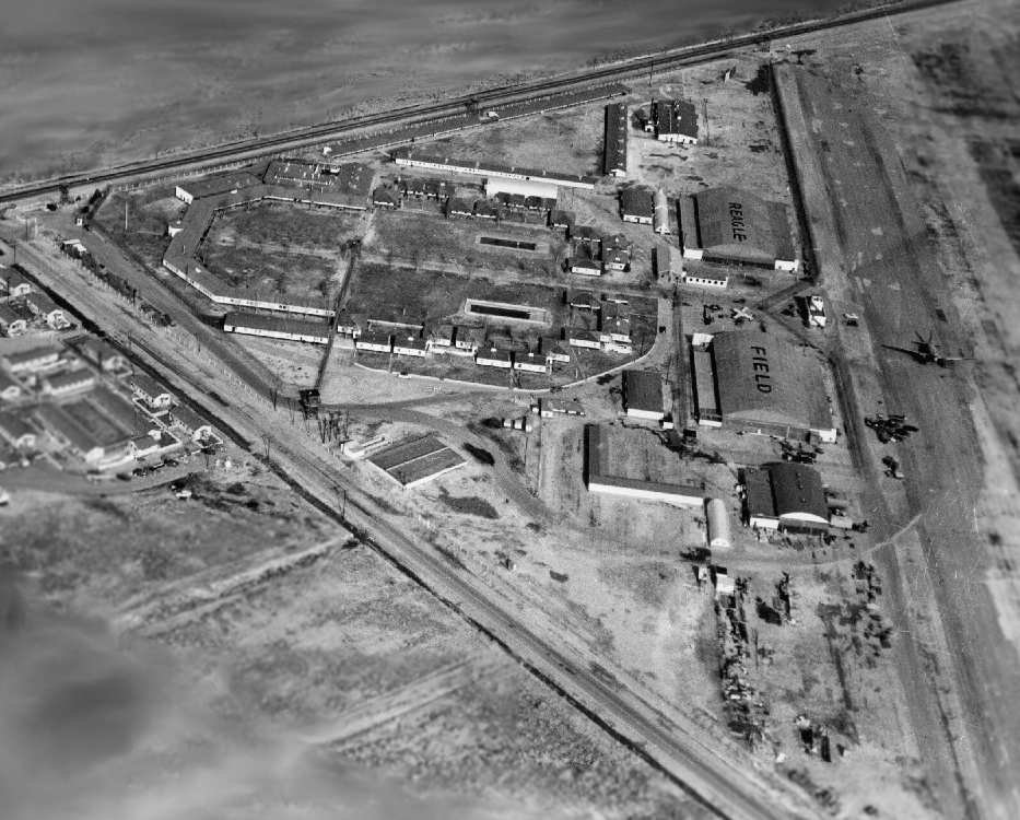
A 1997 aerial view by Dan MacPherson looking north at the WW2-era buildings at Mira Loma.
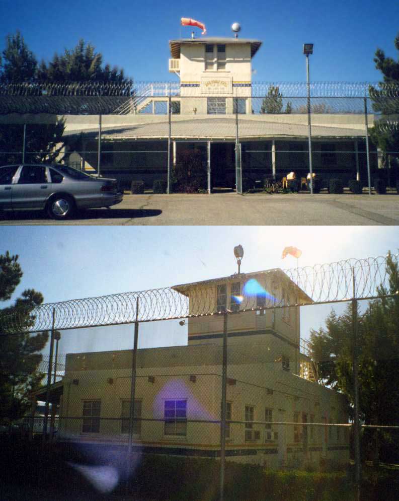
Two circa 1997 photos by Dan MacPherson of the former control tower of War Eagle Field,
now behind the fence of the Mira Loma Detention Center.

A circa 1997 photo by Dan MacPherson of the former Base Administration Building.

A circa 1997 photo by Dan MacPherson of the apparent remains of runway lighting, hidden in some brush near the airport.
They are triangular concrete bases with a fixture (electrical) that looks like it held a light bulb.

A circa 1997 photo by Dan MacPherson of the remains of the wind tetrahedron mount.
Not visible in the photo is the huge circle of rocks around this thing, still painted white after 60 years.

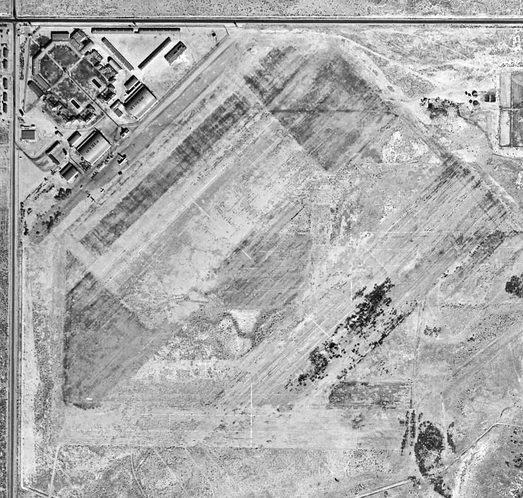
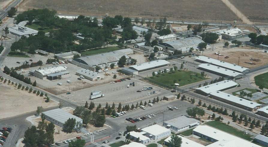
A circa 2001 aerial photo of the site. The WW2-era airfield buildings are in the northwest corner.
As of 2002, the former War Eagle Field was known as the Mira Loma Detention Center.
Two still intact hangars are still in use, as well as other WW2-era buildings.
On the roof of one of the hangars, the name "War Eagle" is still faintly perceptible.
Tim Tyler visited the site of War Eagle Field in 2003,
and he reported that it is "Now a series of detention facilities -
Challenger Memorial Youth Center on north side center,
with LA County Animal Care & Control shelter in front of it.
LA County’s Mira Loma Detention Center is on the northwest side,
and California State Prison LA County is on the entire south side.
Several old hangars & warehouse type buildings are now on the northwest section of the field,
some used by the Mira Loma Detention Center,
and some other potential War Eagle Field-era buildings are occupied by the 'High Desert Hospital'.
which is a former 170 bed hospital, now just an outpatient clinic, for ‘indigent’ people,
the North County Center for Vulnerable Families,
and Antelope Valley Service Planning Area 1 Public Health Administrative Office for LA County Health Services."
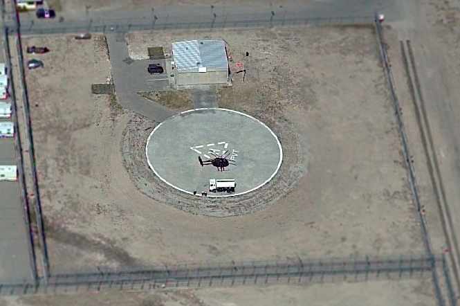
A circa 2005 aerial photo looking north at the helipad on the northeast corner of the Mira Loma facility,
with a single small hangar, and a single MD-500 helicopter on the pad.
The site of War Eagle Field is located southeast of the intersection of West Avenue I & 60th Street West.
The property is labeled "High Desert Hospital" on recent road maps.
See also: http://www.av.qnet.com/~carcomm/wreck19.htm
____________________________________________________
Sky Castle Airport, Del Sur, CA
34.701, -118.394 (West of Palmdale, CA)
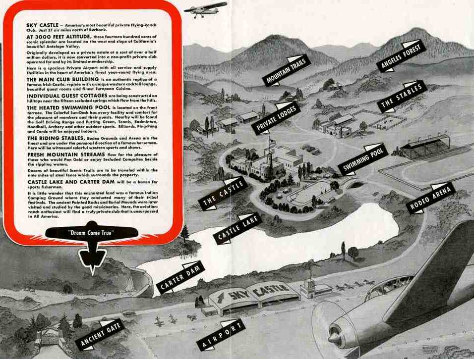
A circa 1940s brochure for Sky Castle (courtesy of Tom Pinard),
depicted the airport along with many features which were never built, including 2 hangars & administration building, rodeo arena, swimming pool, stables, etc.
Much of the following information was contributed by Jon Karkow.
What seems like a mysterious mirage in Los Angeles' backyard,
on the beautiful rolling hills near Del Sur, is a stone replica of a medieval Irish castle.
It is one of Southern California's most overlooked landmarks,
home to such characters as a cowboy star, the builder of Hancock Park & a playboy radio-TV heir.
Secluded on a tranquil hilltop, in the vast openness of the smog free high desert,
Antelope Valley's most curious architectural secret is a single-turreted granite palace fortified in mystery, and fantasy,
its story often known only through a web of rumors.
The surrounding land is still untouched as it was when a Los Angeles real estate baron
decided to build this storybook fortress in 1924.
It would become known as Shea's Castle, after its builder, Richard Peter Shea.
In the early 1920s, New York-born Shea was drawn to California & Lancaster
by the area's isolation & hopes that the clear, dry air would improve the health of his wife, Ellen.
Flush with cash after subdividing Hancock Park & other wealthy Los Angeles enclaves
that sold $56 million worth of property within 3 years,
Shea reportedly spent $500,000 on his 8-bedroom, 7-bath, 7-fireplace, 2-kitchen castle.
It was a boost to the local economy.
Shea hired more than 100 laborers to quarry thousands of tons of granite from boulders on the property
to form the castle's 3- to 5-foot-thick walls.
A stable in a similar motif was built just a short distance away from the castle.
Not long after the work of 2 years was done, the couple moved in.
But the 1929 stock market crash sent Shea's finances plummeting,
forcing the couple to abandon the castle & move back to LA.
Shea borrowed heavily against his castle, and it was taken over by the bank.
The bank was the castle's second owner.
A succession of at least 15 owners & renters over 5 decades followed.
Each left some mark on the castle.
No airfield at this location was yet depicted in the 1941 USGS topo map nor on the 1945 AAF Airfield Directory (courtesy of Scott Murdock).
In the 1940s, the property was purchased by a nonprofit flying club & named “The Sky Castle”.
A 3,000' dirt runway, a stone dam, and the lake were built
to accommodate the flying enthusiasts who flew in for a few hours or the weekend.
Flying Magazine featured a March 1948 article about the property.
The flying club was said to have nearly 300 members,
and its business manager was George Carter.
As many as 50 planes were said to be common on the field for Sunday morning breakfasts.
The airfield was described as a 3,200' “sod” runway.
The most celebrated tenant of the property was Roy Rogers, the singing cowboy star of movies & TV,
who leased the site for a time & trained his famed horse, Trigger.
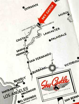
The location of Sky Castle, from a circa 1940s brochure (courtesy of Tom Pinard).
Tom Pinard recalled, “Sky Castle... our father, along with help from us boys, developed the runways & fly-in operation in the 1940s.
Cliff Pinard, owner of Hawthorne Aircraft Industries, the 'Stearman Shop',
was involved with the project, unfortunately short-lived.
We had one of our Stearmans out there to promote project
and as a lad, I recall flying over the Antelope Valley.... Lots of memories.”
Tom confirmed that Sky Castle had “no hangars... there was just a small pre-fabricated 'welcome office' at the strip.
While there were a few weekends of fly-ins, I don't remember any major Hollywood types
with the exception of Edgar Bergen flying in with 'Charlie McCarthy'.
The airport log book is missing but I remember his autograph in it.”
The earliest photo which has been located of Sky Castle was an 11/20/48 USGS aerial view.
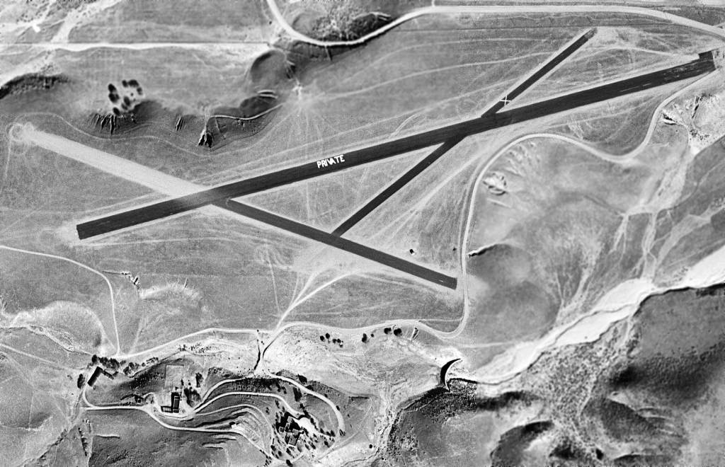
It depicted the field as having 3 newly-paved asphalt runways, with the primary runway prominently marked “PRIVATE”.
The castle was visible to the south of the runway, but no aircraft were visible on the field.

An undated photo from a 1948 magazine article showed 6 planes at Sky Castle parked in front of Shea's Castle (courtesy of Jon Karkow).
Its most notorious owner was millionaire playboy Tommy Stewart Lee.
In 1948, when his father's estate finally emerged from years of litigation,
Lee went on a spending spree, buying more cars, airplanes - and the castle.
With Lee in residence, the castle soon became a favored hangout for fast-driving, hard-living friends.
They landed their planes on the private airstrip that Lee upgraded.
He converted the stable into a garage for his race cars,
and a midget-car racetrack soon wove its way through the rolling hills behind the castle.
But within a few months of his buying the place,
Lee's relatives & business partners had him declared mentally incompetent.
The Sky Castle airfield was not depicted at all on the February 1949 LA Sectional Chart (according to Chris Kennedy),
nor on earlier charts.
In 1950, castle owner Tommy Lee jumped to his death from a fire escape at the top of a 12-story building.
The only aeronautical chart depiction which has been located of the Sky Castle airfield
was on the September 1954 LA Sectional Chart (courtesy of Chris Kennedy).
It described “Sky Castle Field” as having 3 runways, with the longest being a 3,650' "Natural oiled” runway.
A 1954 aerial photo depicted Sky Castle as having 3 unpaved runways.
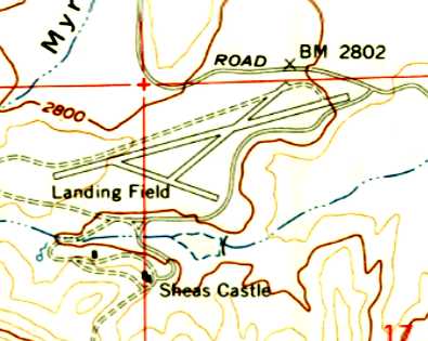
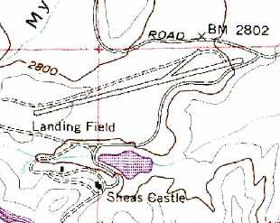
The 1957 USGS topo map depicted the “Landing Field” as having 3 runways.
The Sky Castle airfield was evidently abandoned at some point between 1954-58,
as it was no longer depicted at all on the March 1958 LA Sectional Chart (according to Chris Kennedy),
nor on later charts.
Aerial photos from 1959 & 1965 depicted 3 runways at Sky Castle.
In later years, through a succession of owners, the castle became a backdrop for movies,
such as the 1967 "Blood of Dracula's Castle".
The 1969 USGS topo map still depicted the “Landing Field” as having 3 runways.
A 1971 aerial view showed a change in Sky Castle's configuration, with the 2nd & 3rd runways having disappeared,
and the primary northeast/southwest runway appeared to have been paved at some point between 1965-71.
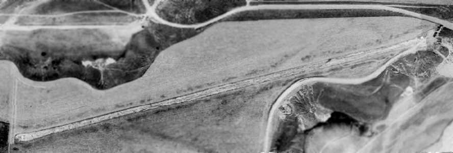
A 1974 aerial view showed Sky Castle to have a single paved northeast/southwest runway.
Sky Castle's 3rd runway had disappeared (along with most of the 2nd runway) from depiction on the 1974 USGS topo map.

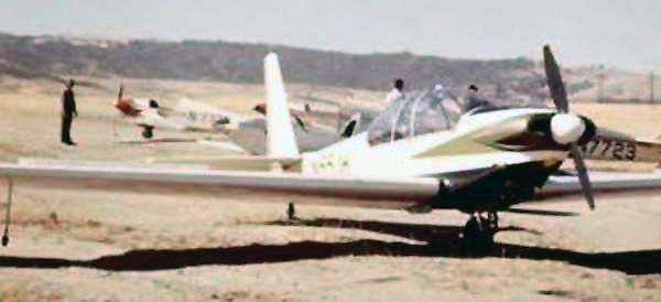
A 1975 photo of Mike Bittner, Mark Lambie, John Buckner, Charlie Webber, Charlie Gyenes, and Maurice Gyenes
in front of a Sportavia-Putzer RF5B motorglider at Sky Castle (courtesy of Collin Gyenes).
Collin Gyenes recalled, “My Dad's friend... was a caretaker at the castle in the mid 1970s.”
The last photo which has been located showing planes at Sky Castle
was a 1975 photo of a 2-seat Sportavia-Putzer RF5B motorglider
and 4 single-seat Sportavia-Putzer Fournier RF4Ds (courtesy of Collin Gyenes).
The Castle was also used as a setting for TV episodes,
including "Bat Masterson", "Air Wolf", "Rat Patrol" and "Buffy the Vampire Slayer".
In 1985, Sherman Oaks-based Genz Development bought the estate.
Plans were drawn up to restore the silted-up lake, install a golf course & other amenities
and divide the rest into 120 large lots for luxury homes.
The plans were halted in the early 1990s due to a change in the local economy.
The estate, which now encompasses 506 acres,
sits hidden in fairy-tale fashion along a section of the California Aqueduct
about 15 miles west of Lancaster/Palmdale, invisible from the nearest thoroughfare, Munz Ranch Road.
Undoubtedly the Castle & the beautiful landscape
have put indelible memories in the hearts of everyone who has visited or owned the property.
The 2002 USGS aerial photo depicted the runway at Sky Castle.
A 2005 aerial photo by Jon Karkow looking northeast at the Sky Castle runway,
with the Castle itself visible at the lower-right.
Jon Karkow reported in 2005, "The property is being sold for subdivision into a housing development – typical story.
I have never seen an airplane use the runway, though it appears in good condition."

A circa 2006 aerial view looking east at the Sky Castle runway,
showing a board with a closed-runway “X” symbol which has been placed at each end of the runway.

A circa 2006 aerial view looking west at the Sky Castle runway,
showing the remains of the airfield segmented circle on the south side of the runway.

A May 2014 photo by Kurtis Clark looking west along the alignment of the Sky Castle runway.
Kurtis observed, “I could see a cement pad at the end of the runway with an 'X' on it.”
The site of Sky Castle is located northwest of the intersection of Munz Ranch Road & Fairmont Road.
____________________________________________________
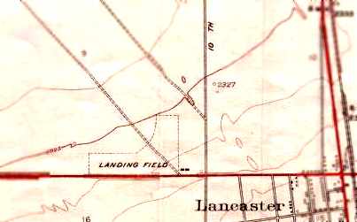
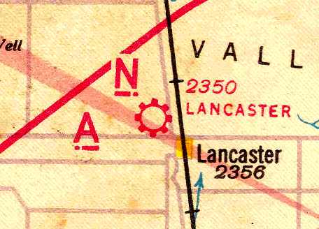
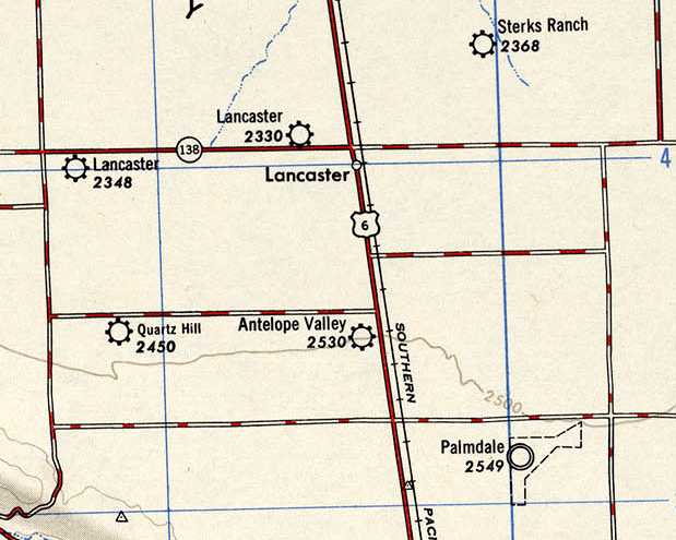
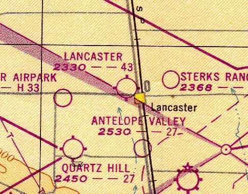
Lancaster Airport (original location), Lancaster, CA
34.71, -118.155 (North of Palmdale, CA)
Lancaster Airport, as depicted on the 1929 Rand-McNally Air Trails Map of CA (courtesy of Chris Kennedy).
The original airport for the town of Lancaster was located adjacent to the northwest side of the town.
The date of construction of Lancaster Airport has not been determined.
The earliest depiction of the field which has been located
was on the 1929 Rand-McNally Air Trails Map of CA (courtesy of Chris Kennedy).
It described Lancaster as a municipal airport, operated by the City of Lancaster.
The field was said to measure 2,000' x 1,250'.
The 1929 Airplane Landing Fields of the Pacific West (courtesy of Chris Kennedy)
described Lancaster as a municipal airport, operated by W. B. Carter.
The field was said to consist of 2 dirt runways in an “L” shape: 2,250' east/west & 1,350' north/south.
A hangar on the southeast corner was said to be marked with “Lancaster”.


The earliest aeronautical chart depiction which has been located of Lancaster Airport was on the 1932 LA Sectional Chart (courtesy of Rogr Connor).
It depicted Lancaster as a commercial/municipal airport.
The 1933 USGS topo map (courtesy of the CA State University, via Chris Kennedy)
depicted the Lancaster “Landing Field” as having being oriented east/west & north/south.
Lancaster was depicted as a commercial or municipal airport on the June 1940 LA Sectional Chart (courtesy of Chris Kennedy).
The Airport Directory Company's 1941 Airport Directory (courtesy of Chris Kennedy)
described Lancaster as a commercial airport.
The field was said to consist of 2 sand runways in an “L” shape: 2,600' east/west & 2,000' north/south.
The Lancaster Airport may have been temporarily closed at some point between 1941-44
(like many other small civilian airports near the coasts due to wartime security concerns),
as it was not listed among active airfields in the April 1944 US Army/Navy Directory of Airfields (courtesy of Ken Mercer).
The August 1945 USAAF Pilot's Handbook (courtesy of Chris Kennedy)
depicted Lancaster Airport as having 2 runways: east/west & northeast/southwest.
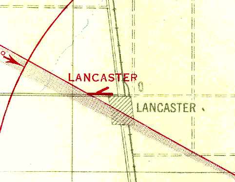
The original Lancaster Airport, as depicted on the 1947 USGS topo map.
An 11/20/48 USGS aerial photo depicted Lancaster Airport as having 4 unpaved runways, and 8 single-engine light planes & a few small buildings on the southeast side.
The last chart depiction which has been located of the original Lancaster Airport as an active airfield
was on the February 1949 LA Sectional Chart (courtesy of Dan MacPherson).
It depicted Lancaster as having a 4,300' unpaved runway.
The original Lancaster Airport was evidently closed at some point between 1949-52,
as it was no longer depicted at all on the 1952 Flight Chart (according to Chris Kennedy).
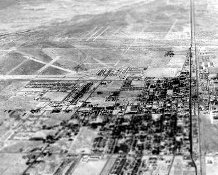
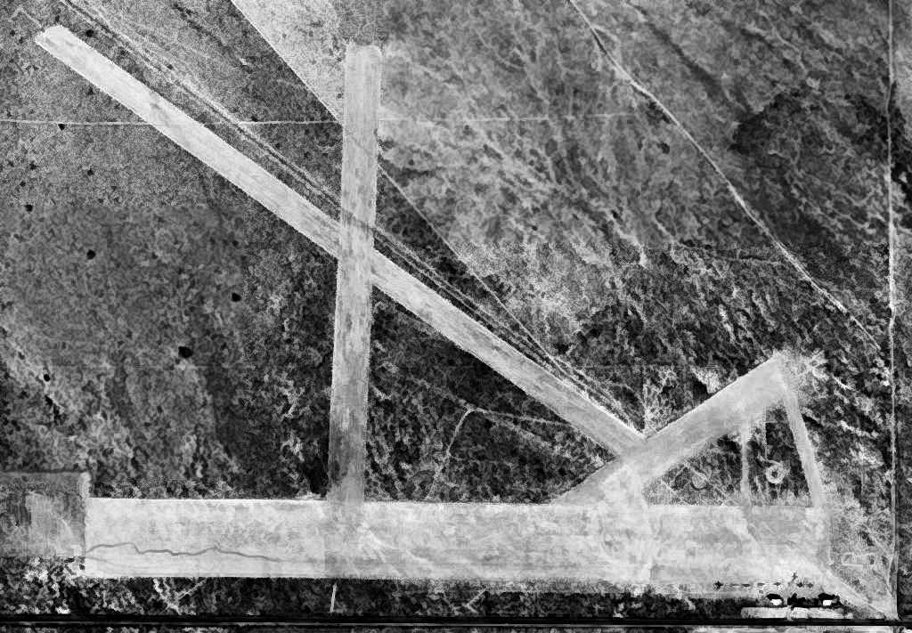
In a 1952 aerial view looking north at the town of Lancaster,
the western half of several runways of the Lancaster Airport could still be seen (top-left of picture),
but it appears as if new roads had already covered the eastern portion of the former airport.
A 1953 aerial photo showed the original Lancaster Airport having 3 dirt runways,
as well as 2 much smaller runways to the northeast (a predecessor field?).
There did not appear to be any aircraft on the field.
Patrick Ryan recalled, “The old Lancaster Airport at 10th Street West & Avenue I still had aircraft on it in mid-1954.
I remember seeing my first T-6 Texan in a dark blue paint job & other civil aircraft.”
Don Hyneman recalled, “A few years later that [the original Lancaster Airport] became housing tracts & Desert View Elementary School.
I used to walk there from the new housing tract near 10th Street West & Avenue H-8 (all dirt in the 1952 picture).
We moved in our new house in March 1955.
I always wondered why there was this nice flat dirt road at such an odd angle.”
In the 1959 aerial photo, not a trace was still recognizable of the former Lancaster Airport,
as the site had been filled in with dense housing.
The 1959 USGS topo map also depicted new streets covering the airport site.

A 2006 aerial photo, annotated by Chris Kennedy to show the outline of the former Lancaster Airport.
The site of the original Lancaster Airport is located northwest of the intersection of Sierra Highway & West Avenue I.
____________________________________________________
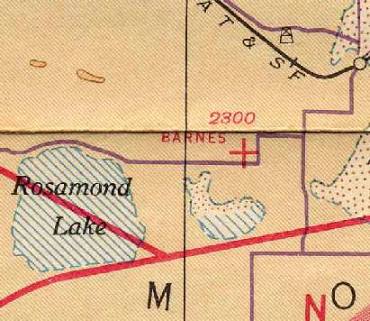
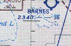
Pancho Barnes Airfield, Rosamond, CA
34.865, -117.966 (West of Edwards AFB, CA)
Barnes Airfield, as depicted on the 1941 LA Sectional Chart (courtesy of Chris Kennedy).
If you look 4 miles southwest directly along the extended centerline of the primary runway at Edwards AFB,
you will see the remains of another historic airfield, deteriorating in the desert sun.
It was this unlucky coincidence,
being located along the centerline of what would become the world's premier flight test center
that ultimately led to this field's unhappy closure.

An undated portrait of Pancho Barnes.
Former Hollywood stunt pilot Pancho Barnes purchased 80 acres of desert farmland in 1935
near a small Army Air Corps gunnery range at Rogers Dry Lake.
The small gunnery range eventually became Muroc Army Airfield,
which would play a large role in the future course of Barnes' ranch.
The ranch was a working ranch at first, growing alfalfa & raising livestock.
But Pancho was never without an airplane,
and one of the first things she did was to scratch out an airstrip on the desert hardpan.
Pancho set out to make the most of her new environment.
Due to the steady growth of the nearby Muroc AAF,
Pancho expanded her ranch to include 2 bars, a restaurant, a dance hall,
a motel & even a swimming pool - an exotic touch for the late 1930s.
Within a few years the ranch had expanded from 80 acres to 368.
The airmen loved Pancho’s party atmosphere as the opportunities for other recreation were severely limited.
Most of the booze came up from Mexico in Pancho’s plane & was dispensed freely.
The airstrip was enlarged & illuminated for the increasing number of guests & friends who flew in.
Soon Pancho found herself the proud mistress of the "Rancho Oro Verde Fly-Inn Dude Ranch".
Among military flyers, the ranch eventually became nicknamed the "Happy Bottom Riding Club".
The earliest chart depiction of the Barnes Airfield which has been located
was on the 1941 LA Sectional Chart (courtesy of Chris Kennedy).
Barnes Airfield was not yet depicted on the 1942 USGS topo map.

The earliest photo which has been located of Pancho Barnes Airfield was a 7/22/43 aerial view looking east
from the 1945 AAF Airfield Directory (courtesy of Scott Murdock).
It depicted the field as having 3 graded dirt runways, with a few small buildings on the northeast side.
The 1945 AAF Airfield Directory (courtesy of Scott Murdock) described Barnes Airport
as a 140 acre square-shaped property having a 3,800' northeast/southwest bare runway,
with a single 80' x 50' hangar on the northeast side.
The field was said to be owned by private interests, but not in current operation.
After WW2, when Muroc continued to expand in its new role
as the Air Force's primary flight test center (eventually becoming Edwards AFB),
the party went on at Pancho’s place.
Pancho was a staunch friend & confidante to many of the young fliers of the day:
Al Boyd, Pete Everest, Jack Ridley & many others.
With Chuck Yeager, a bond was formed which lasted her lifetime.
When Yeager broke the "sound barrier" in the X-1 in 1947,
Pancho was one of the few who knew about the official secret.
Yeager won a free steak dinner from Pancho for that feat,
thereby starting a tradition for all pilots celebrating their first supersonic flight.
Pancho’s barroom was at the literal center of the supersonic age
and served as the unofficial debriefing room for the most elite test pilots in the world.
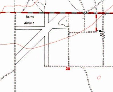
The 1947 USGS topo map misspelled the name of the field as “Barns Airfield”,
but depicted it with 3 runways with 1 small building on the northeast side.
Pancho Barnes Airfield, as depicted on the 1948 USGS topo map.

The only photo which has been located showing aircraft at Pancho Barnes Airfield was an 11/20/48 USGS aerial view.
It depicted the field as having 3 graded dirt runways,
with a small hangar & another small building on the northeast side.

A closeup from the 11/20/48 USGS aerial photo of Pancho Barnes Airfield,
showing 3 single-engine aircraft parked on the field.
After the first pool was destroyed in the 1952 Tehachapi earthquake,
a much more elaborate pool was built to replace it,
consisting of 2 massive, inter-connected quarter sections,
customized with special options demanded by Pancho including recessed underwater lighting
and, most astonishingly, a gently sloping ramp that allowed Pancho & her horse,
after particularly arduous rides, to cool off by walking directly into the pool.
At nighttime, the shimmering, iridescent blue-green glow of the swimming pool
became an unmistakable navigational beacon for fliers overhead.
In fact, it was then the only pool in the Antelope Valley.

An undated photo of the sign for “Pancho's Guest Ranch Hotel & Happy Bottom Riding Club”.
Pancho’s remote 368 acre Rancho Oro Verde property was,
at the height of its fame, reachable only by air or a brutal 20-mile dirt road from Lancaster.
In spite of its isolation, the compound offered a swanky 20 room motel
surrounding a remarkable 80’ fountain in the shape of the Army Air Corps insignia,
a well-stocked horse corral, a restaurant, airplane hangars, 3 landing strips, a dance hall, gambling den
and the world-famous bar where she hosted what she called "the fastest & bravest men on earth."
Bordered by lush planting of cottonwoods, Chinese elms, poplars & bamboo,
the Happy Bottom Flying Club was a verdant oasis in the desert & the site of a lifestyle as exuberant as its host.
Yeager’s boss in the flight test world, Col Albert Boyd,
was another legendary old-time pilot who had warm regard for Pancho & her accomplishments.
But after his departure from Edwards in 1952, the good times rapidly drew to a close.
Soon after the next commander arrived on the scene, the entire atmosphere began to change.
The reasons were many: conflicting requirements, personality clashes, and some genuine misunderstandings.
The immediate catalyst was airspace,
which was becoming increasingly crowded with large numbers of new aircraft being tested,
and the private airplanes of Pancho’s guests.
The borders of the base were already pressing hard upon Oro Verde,
and a master plan had already been written calling for it to expand to its present western boundary.
There was even talk of lengthening the Edwards runway to a total of 27 miles (!),
to accommodate the atomic-powered aircraft then on the drawing board (see Test Area North, ID).
Given that it was located only 4 miles away from the end of Edwards' Runway 4,
directly along the extended centerline,
the Happy Bottom Riding Club was doomed.
It was not long before condemnation proceedings were filed against Pancho’s property,
on the grounds that the ranch lay on a direct line with a proposed extension of the test center’s main runway.
But the situation was greatly worsened by a complete lack of rapport between the principals,
and conflicts soon escalated into name calling, unjust accusations,
and ultimately into a flurry of acrimonious lawsuits.
In the middle of the fray, in 1953, coming at the worst possible time,
a "mysterious" nighttime fire burned down the main buildings of the ranch,
taking its memories of Hollywood celebrities with it.
The September 1954 LA Sectional Chart (courtesy of Chris Kennedy)
continued to depict Barnes Airport, and described the field as having a 3,600' unpaved runway.
Later in 1954, as part of the expansion of the base boundaries,
Barnes' former ranch became part of the Edwards AFB property.
A 1959 aerial view showed Barnes Airport to consist of 3 dirt runways.
Barnes Airport was no longer depicted at all on the March 1960 LA Sectional Chart (courtesy of Dick Welsh)
nor on the 1969 USGS topo map.
According to Patrick Ryan, “When Pancho died [1975]
her son was allowed to fly over her old ranch at Edwards AFB to spread her ashes.”
No traces of the former Barnes Airport were depicted on the 1982 or 1994 USGS topo maps.

A 1994 USGS aerial view of the remains of the Pancho Barnes Airfield runways.
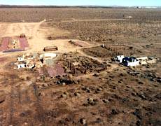
Recent photo of the remains of the "Happy Bottom Riding Club".
An aerial view by Richard Menzies of the remains at the "Happy Bottom Riding Club".
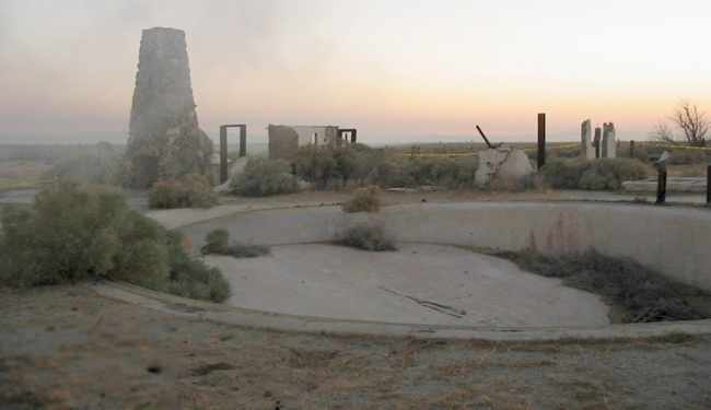
A circa 2003 photo of the remains of the swimming pool,
Today, the remains of her ranch are now part of the base’s small arms firing range.
The outline of the former airfield is still perceptible in aerial photos of the site,
with 3 runways: north/south, east/west,
and the primary runway, which runs northeast/southwest & is 5,500' long.
According to Dan MacPherson,
Pancho's hangar was purchased by Gus Briglieb & moved to El Mirage airport, where it still exists.
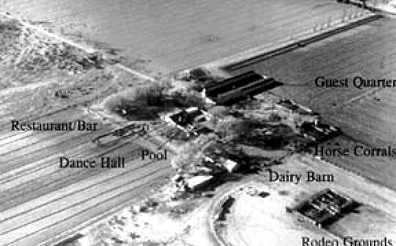
East of the airfield are the remains of the ranch.
Although the main building of the Happy Bottom Riding Club was lost in the fire, other things remain.
The remarkable 4-tiered cascading fountain that graced the motel esplanade still stands,
as well as the double-sided fireplace from the dining room.
On the east side of the ranch is the infamous wooden gate which Yeager struck on horseback (breaking 2 ribs),
the night before he became the first man to break the sound barrier.
Even the swimming pool remains largely intact.
North of what were the main buildings are the remains of a Ryan PT-19 aircraft
which was ‘borrowed’ by 2 young locals from Pancho’s personal fleet of airplanes & crashed short of the main runway.
According to the Edwards AFB web site, "visiting is prohibited for safety reasons".
In memory of the old days, however,
Air Force Flight Test Center personnel hold an annual barbecue on the old foundations of the club.
And in a hangar in nearby Mojave, Pancho’s black & red Travel-Aire Mystery Ship
is being restored to its original splendor.
Good news for the Pancho Barnes site came in 2014, when an Edwards AFB article (courtesy of Leigh Kelly)
reported how her Rancho Oro Verde site had been recommended as eligible for listing on the National Register of Historic Places,
and the 412th Test Wing Civil Engineering would work to preserve the site.

A 2015 aerial view showed the recognizable remains of 3 runways at the site of the Pancho Barnes Airfield.
The site of Barnes Airfield is located west of the intersection of Willow Springs Road & Barnes Road.
----------------------------------------
Note: The buildings of the former Barnes Motel were relocated at some point from her ranch
to 14301 Frontage Road, which is across the highway from the north base entrance to Edwards AFB.
Dan MacPherson photographed the buildings in 1998, which were being used as the Desert Sage Apartments.
See also:
http://www.edwards.af.mil/history/docs_html/people/pancho_barnes_biography.html
http://www.edwards.af.mil/articles98/docs_html/splash/jun98/cover/pancho.htm
http://www.clui.org/clui_4_1/lotl/00f/00f3a.html
____________________________________________________
Antelope Valley Intermediate Field Site 5 / Site 5B, Gorman, CA
34.79, -118.657 (Northwest of Los Angeles, CA)

Intermediate Field 5B,
as depicted on the 1929 "Rand McNally Standard Map of CA With Air Trails" (courtesy of Chris Kennedy).
Photo of the airfield while open has not been located.
This field was built as one of the Department of Commerce's network of Intermediate Fields,
established along commercial airways to serve as emergency airfields for airliners & airmail planes.
The date of construction of the Antelope Valley field has not been determined.
The earliest reference to the field which has been located
was in the Standard Oil Company's 1929 "Airplane Landing Fields of the Pacific West" (courtesy of Chris Kennedy).
It described the "Antelope Valley Field Site 5" as being a Department of Commerce Emergency field.
The field was said to consist of a 3,000' x 1,000' cleared area.

The only aeronautical chart depiction which has been located of the Antelope Valley Intermediate Field
was on the 1932 LA Sectional Chart (courtesy of Roger Connor), which labeled it as CAA Site “5B”.

A 1941 street map (courtesy of Chris Kennedy) depicted a rectangular plot of land labeled "U. S. Airport",
along with a single building along the southeast portion of the field.
No airfield was depicted on the Antelope Valley Intermediate Field site on a 1946 aeronautical chart,
or on USGS topo maps from 1939, 1943, 1947, 1974, 1975, or 1981.
A 1952 aerial view showed the Antelope Valley Intermediate Field site was comprised of farm fields,
with no recognizable trace of an airfield.
A single building sat on the southwest corner of the property -
it has not been determined if this building dated from the property's days as an airfield.
The 1994 USGS aerial photo of the Antelope Valley Intermediate Field site showed that the northern half of the property
had been covered at some point between 1972-94 by a circular irrigation track.

No trace of the Antelope Valley Intermediate Field was recognizable in a 2015 aerial photo.
The site of the Antelope Valley Intermediate Field is located in the extreme northwest corner of Los Angeles County,
northwest of the intersection of Route 138 & 290th Street West.
____________________________________________________
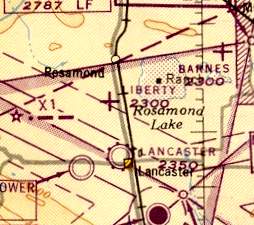
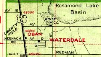
34.8, -118.16 (North of Palmdale, CA)

The August 1945 USAAF Pilot's Handbook (courtesy of Chris Kennedy)
depicted Liberty Field as having 2 runways: east/west & northeast/southwest.
Photo of the airfield while open has not been located.
The date of construction of Liberty Field is unknown.
It was reportedly established before WW2 by a local resident, Mr. Mallicoat,
as a private training school for military pilots.
However, it was evidently built at some point between 1941-44,
as no airfield at the site was depicted on the 1941 LA Sectional Chart (courtesy of Chris Kennedy) nor on the 1943 USGS topo map.
Liberty Field became one of 2 auxiliary landing fields (the other being Victory Field)
associated with the Polaris Flight Academy,
which operated during WW2 from nearby War Eagle Field.
The Polaris Flight Academy was a contract flying school which used civilian instructors
to provide flight training to US & foreign military cadets.
The 1944 US Army/Navy Directory of Airfields (courtesy of Ken Mercer)
described "Liberty, Army" as having a 3,900' hard-surface runway.
The earliest depiction which has been located of Liberty Field
was on the August 1945 USAAF Pilot's Handbook (courtesy of Chris Kennedy).
It depicted Liberty Field as having 2 runways: east/west & northeast/southwest.
Liberty Field was still depicted as an auxiliary airfield
on the 1945 Mojave AAF Aeronautical Chart (courtesy of Dan MacPherson).
The Polaris Flight Academy (renamed the Mira Loma Flight Academy) ended its training operations at War Eagle Field in 1945,
but Liberty Field apparently remained in operation as an airfield for a few more years.
Liberty Field was still depicted as an active auxiliary airfield
on the February 1947 LA Sectional Chart (courtesy of Chris Kennedy).

The 1947 USGS topo map depicted Liberty Field as consisting of 2 wide runways, labeled as “Landing Field”,
with 4 small buildings on the east side.

A 11/20/48 USGS aerial photo of Liberty Field (courtesy of Brian Rehwinkel).
Brian Rehwinkel observed, Liberty Field was “probably abandoned at this point, you can still see markings on the field.
You can see what looks like a hangar (?) and another small building at the northeast corner of Liberty Field.
[Some] type of structure (it almost appears to be an igloo) seems to be present immediately south of the intersection of the 2 runways.
One of the interesting things I noticed in looking at the aerial photo of Liberty Field is the 'transparency' of the runway paving.
If you look carefully, you can see that some of the ground features that appear on landscape around the field seen to continue under the runways.
I don’t know, but I suspect the field was paved with a dust palliative (a mix of sand & oil or a light layer of asphalt).”
Liberty Field was evidently closed as an airfield at some point between 1947-49,
as it was no longer depicted on the February 1949 LA Sectional Chart (courtesy of Chris Kennedy).
Liberty Field was still depicted (on the western edge) of a 1950 Pocket Atlas (courtesy of Dan MacPherson),
but that does not necessarily indicate that it was still an open airfield at that point.
In the 1950s the US Rubber Company constructed a 3,500' diameter circular automotive testing track,
roughly superimposed over the center of the former airfield.
“They would bring tires up from the Los Angeles factory which has an amazing history all it's own”, according to John Smith.
A 1953 aerial photo depicted the circular test track, within which was still visible the outline of the 2 runways.
One small building appeared to remain from the site's airfield days, within the test track, on the southeast side of the runways.
Nothing was depicted at the site of Liberty Field on the 1954 USGS topo map.
Patrick Ryan recalled, “At Liberty Field there was a building that looked like a very large garage back in the mid-1950s
with 'B.F. Goodrich' across the upper east side of the building.”
The 1957 USGS topo map depicted the circular “Test Track” covering the site of Liberty Field,
and no longer depicted the runways.
Dodge acquired the test track from US Tire (Uniroyal) in the 1960s, according to locals (via John Smith).

A 1972 aerial view depicted the original Liberty Field's 2 runways,
with the more recent circular test track having been built over it.
One small building appeared to remain from the site's airfield days, within the test track, on the southeast side of the runways.
A 1974 aerial photo showed that the last airfield building appeared to have been removed at some point between 1972-74.
“The test track was last maintained by the Dodge Motor Company”, said John Smith.
“It closed down completely in the 1970s when they moved to facilities further out in the desert.”
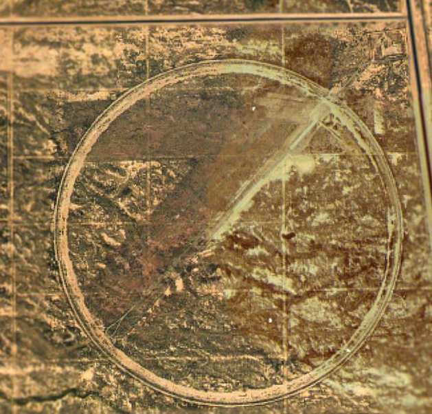
The circa 2001 aerial photo depicted the remains of 2 former runways,
over which the circular test track was later constructed.
One former runway was oriented east/west, the other northeast/southwest, together forming a number "7".
Both runways remained quite discernible, but in a fairly deteriorated state.
There were no perceptible remains of any buildings at the site.
The entrance to Liberty Field, as photographed by Rick Jackson in 2003.
"This is on Sierra Highway, just before the corner of Avenue B.
You can see the red entrance walkway to the cement pad behind it.
You can't see it in this photo, but there are curbs coming out from both sides of the beginning of the walkway.
I don't know if this is from WW2 or US Rubber.
You can't see this from Sierra Highway because a drainage ditch & berm have been built in front of it."
A 2003 photo by Rick Jackson.
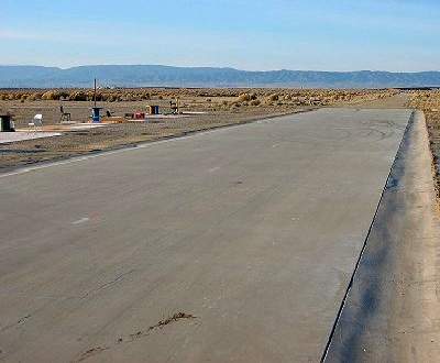
"Liberty Field looks like it's become home to model airplane flyers.
This section has been nicely paved. This is looking towards the SW.
Towards the end of the paved section is an asphalt section, with another paved section following that."

A 2003 photo by Rick Jackson. Rick noted, "This is looking from the asphalt section towards the northeast.
On the left is part of the original runway, and US Rubber test area."
Rick Jackson visited the site of Liberty Field in 2003.
He reports that several sections of relatively new looking pavement
appear to have been constructed for the use of model aircraft.
"The circular track around the runway is up on a berm.
From what I saw it's still drivable,
as long as you don't mind getting your car scratched from the bushes.
There's more concrete pads around, but who knows from what era."
John Smith visited the site of Liberty Field in 2005, and reported,
“The test track is actually inclined to about a 40 degree angle
and is surmounted by a highly decayed paved service road.
When we drove down into the bowl of the test track,
it's looked much like the photos [posted above].
The entire bowl area is paved to varying degrees,
but is decaying badly away from the track section & the central skid pads (now concrete model airplane runways).
The northeast/southwest runway is now heavily overgrown
and is nearly unrecognizable by casual examination.
Only close viewing or airborne observation would indicate an airfield existed there.
All extant building foundations nearby all date to the US Tire era.
We were unable to find possible sites for the airfield's administration building or hangars
(most likely on the north side of the field near or across Avenue B).
Squatters are living in & around the area & we didn't wish to risk confrontation.”
Hal Arbogast reported in December 2005, “I've just completed a metal detector sweep
of the East/West Liberty Field runway (in the dirt on the north side of the runway, Avenue B side),
having swept the Northeast/Southwest runway (in the dirt on the eastern side) about a month ago.
I found one piece of re-bar in the latter sweep,
but today recovered numerous old steel/iron construction bolts, carriage bolts, etc.
on the Avenue B side of the East/West runway
that bolsters your observation that hangars & administrative offices existed near Avenue B.
I even found the remains of a common table knife (no handle though).
I also found several areas of tarmac perpendicular to the East/West runway (toward Avenue B)
where aircraft mooring/parking possibly occurred,
and a cable 'termination' device possibly indicating the existence of aircraft tie-down cables.
Having prowled ruins in the desert Southwest for 20+ years,
I firmly believe the concrete pads I've come across during my sweeps on Liberty Field are all of the tire test track vintage...
typically pre-WWII structures were raised structures supported by partial concrete (or other materials),
and not full concrete foundations.”

A 2007 aerial view by Philip Pesce looking northeast at the site of Liberty Field.
Alan Radecki reported in 2008, “Liberty Field... The entire square mile plot of land, along with the square mile immediately south of it,
has been fenced off & will be plowed up for the construction of the expanded waste water treatment plant that serves the area.
Sad to see the airfield go!”

An October 2014 aerial view by Dustin Mosher looking southwest at the site of Liberty Field,
with the southern portion covered by a wastewater treatment facility.
Dustin observed, “The old runway outlines are still clearly visible. There is also a disused private strip to the west of the airport, opposite Highway 14.”
The site of Liberty Field is located southwest of the intersection of Sierra Highway & West Avenue B,
5 miles south of Rosamond.
Thanks to Dan MacPherson for determining the location of Liberty Field.
See also: http://www.av.qnet.com/~carcomm/wreck19.htm
____________________________________________________
34.785, -118.27 (North of Palmdale, CA)
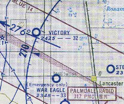
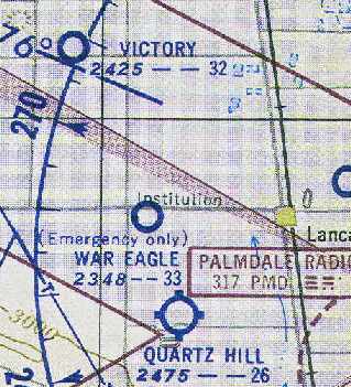
Victory Field, as depicted on the September 1954 LA Sectional Chart (courtesy of Chris Kennedy).
Photo of the airfield while open has not been located.
Victory Field was one of 2 auxiliary landing fields (the other being Liberty Field)
used during WW2 to support the training operations at Polaris Flight Academy, based at the nearby War Eagle Field.
The Polaris Flight Academy was a contract flying school which used civilian instructors
to provide flight training to US & foreign military cadets.
The date of construction of Victory Field has not been determined,
but it presumably was built during WW2, and was not a pre-war airfield.
Victory Field was not listed among active airfields
in The Airport Directory Company's 1937 Airport Directory (courtesy of Bob Rambo),
depicted on the 1941 USGS topo map, nor listed in the April 1944 US Army/Navy Directory of Airfields (courtesy of Ken Mercer).
The Polaris Flight Academy (renamed the Mira Loma Flight Academy) ended its training operations at War Eagle Field in 1945,
and at this point it is presumed that Victory Field was abandoned (at least for a few years).
It was not depicted at all on the 1945 or 1947 LA Sectional Charts (courtesy of Chris Kennedy)
nor on the 1947 USGS topo map.

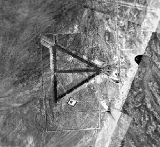
A 11/20/48 USGS aerial photo of Victory Field (courtesy of Brian Rehwinkel).
Brian Rehwinkel observed, Victory Field was “probably abandoned at this point, you can still see markings on the field.
The photo for Victory Field does not show any identifiable building,
although there seems to be a small structure immediately south of the intersection of the pair of runways making up the south field for Victory Field
and the same type of structure (it almost appears to be an igloo) appears immediately north of the intersection of the northern runways that make up Victory Field.”
Victory Field was not depicted at all on the 1949 LA Sectional Chart (courtesy of Chris Kennedy).
However, Victory Field was apparently reopened as a civilian airport at some point between 1949-54,
as the September 1954 LA Sectional Chart (courtesy of Chris Kennedy)
depicted "Victory" as a civilian public-use airfield.
The Aerodromes table on the chart described Victory as having a total of 4 runways,
with the longest being a 3,200' "Field mix" strip.
A 1954 aerial photo showed the remnants of Victory Field: a total of four 2,800' runways,
divided into 2 pairs of east/west & northeast/southwest strips.
Victory Field was evidently closed (for reasons unknown) at some point between 1954-58,
as it was no longer depicted as an airfield on the March 1958 LA Sectional Chart (according to Chris Kennedy).
However, the 1958 Sectional did continue to depict a reporting point at that same location labeled "Victory".
No airfield at this location was depicted on the 1959 USGS topo map.

A 1972 aerial photo showed the remnants of Victory Field: a total of four 2,800' runways,
divided into 2 pairs of east/west & northeast/southwest strips.
Leigh Kelly reported in 2005 that she had heard 2nd-hand that “remnants of Victory Field were still visible”
when an acquaintance first moved to Little Butte (the more-recent-airfield adjacent to the northeast side of the site of Victory Field).
Todd Schultz remarked in 2005, “Depending on the time of year, the runways completely blend in with the desert
but after all the rain this year most of the weeds can’t grow through the pavement.
The runways look like they were paved or hard packed tar-gravel mix.
There are remnants of 2 concrete buildings on the south side of each set of runways that have deteriorated & fallen down.”
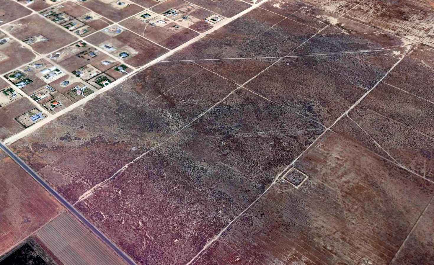
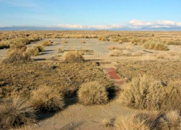
A 2015 aerial view looking northwest showed the remnants of Victory Field's multiple runways were still recognizable.
The site of Victory Field is located northeast of the intersection of West Avenue D & 90th Street West.
____________________________________________________
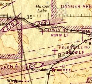
Hawes Aux Army Airfield #1, West of Barstow, CA
34.923, -117.375 (Northeast of Los Angeles, CA)

A 6/4/42 AAF aerial view looking south at Victorville Aux AAF #1 (from the National Archives, courtesy of Brian Rehwinkel).
This airfield was built during WW2 as one of 4 satellite fields for Victorville AAF (later renamed George AFB),
which participated in the 30,000 Pilot Training Program & later became a bombardier school.
Hawes was evidently established at some point between 1940-42,
as it was not yet depicted on the 1940 USGS topo map.
The earliest depiction which has been located of the field
was a 6/4/42 AAF aerial view looking south at Victorville Aux AAF #1 (from the National Archives, courtesy of Brian Rehwinkel).
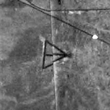
It depicted the field in its original configuration, with 4 paved runways.

A 4/20/43 AAF aerial view of Victorville Aux AAF #1 (from the National Archives, courtesy of Brian Rehwinkel)
showed construction underway to extend 3 of the runways.
A close inspection will reveal paving trucks & equipment on the north end of the runways.
The earliest aeronautical chart depiction which has been located of the Hawes Aux AAF
was on the 1944 LA Sectional Chart (courtesy of John Voss).
The 1944 US Army/Navy Directory of Airfields (courtesy of Ken Mercer)
described "Hawes Aux. #1, Army" as having a 5,600' hard-surface runway,
and the remarks included, "Auxiliary to Victorville AAF."
The 1945 Mojave AAF Chart (courtesy of Chris Kennedy) depicted Hawes #4 as an auxiliary airfield.
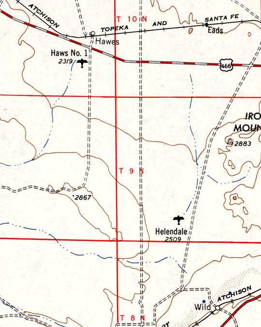
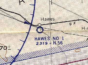
“Haws #1” [sic], as depicted on the 1948 USGS topo map.

The 1956 USGS topo map depicted Hawes Auxiliary Airport as having 4 paved runways.
"Hawes #1" was still depicted as an active military airfield on the 1960 LA Sectional Chart (courtesy of Chris Kennedy).
It was described as having a 5,600' hard-surface runway.
The Hawes airfield was evidently closed at some point between 1960-64,
as it was not depicted at all on the 1964 LA Sectional Chart (courtesy of John Voss).
A 1964 aerial view (courtesy of Bob Anderson)
depicted the Hawes airfield as having 4 paved runways laid out in a triangular configuration.
The radio site had not yet been built adjacent to the airfield.
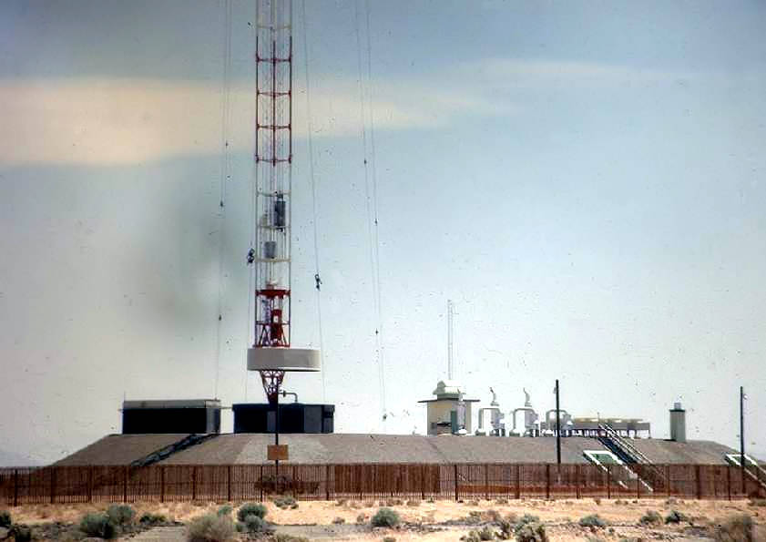
At some point between 1964-67,
a large Air Force radio relay station was built adjacent to the south side of the Hawes airfield,
named the "USAF Survivable Low Frequency Communications System Site, Hawes" (according to Tim Tyler).
On the 1967 LA Sectional Chart (courtesy of Chris Kennedy),
the Hawes site was marked with an obstruction symbol (approximately 1,000' above ground level),
due to the massive radio tower which occupied the site.
A 1968 aerial view of the former Hawes airfield (courtesy of Bob Anderson).
clearly depicted the new perimeter fence which had been constructed to enclose the new Air Force communications site,
as well as the antenna blockhouse just south of the runways.
The runway pavement appeared to remain intact.

An amazing picture from a unique perspective: a 1968-70 photo by Lyle Abel looking 1,000' straight down from the top of the Hawes radio tower.
Lyle observed of the picture, “The radials that you see in the desert are copper cables buried in the desert to form a counterpoise (a good ground reference for the RF transmitter).
They originate at the base of the tower & are separated by a degree, roughly, to an engineered point in the desert.”
Lyle Abel recalled, “I was stationed at the Hawes T/R site from 1968-71... I was one of the shift supervisors there.
We lived on Edwards AFB & would drive to the site for a 24 hour shift.
This was truly state-of-the-art equipment. When I arrived I didn't recognize any of it as high power radio equipment.
It looked like banks of computers to me. After I became familiar with the equipment I learned to really respect & appreciate it, I thoroughly enjoyed working with it.
On one occasion, someone peeked into the 'helix' room & noticed that it was flooded with water... a little scary, since there was 110 KW of RF energy floating around in there.
The contractor had failed to cap one of the pipes going from that room to the outside area. There had been flooding in the area & it ran into the room.
We got permission to shut down the transmitter & it took us most of the day to get rid of the water.
The barbwire fence was broken up in short lengths...not because it would affect the LF/VLF system, but because it would knock you on your butt it you touched it.
The short lengths could not build up a high voltage from the LF/VLF transmitter RF cutting through the wire 24 hours per day.
I can attest to that, because I was dumb enough to grab a loose length of wire on a light pole in an attempt to get rid of it... big shock!
When I arrived people were outside during shift changes, lunch, volleyball games & BBQs on weekends with the transmitter at full power.
We were all told that at that frequency 20-60 khz there was no danger.
After being there for 2 years HQ AF came out with an order that the site would be shut down for shift change
and people should not be outside while the transmitter was at full power... SCARY!
The transmitter was built by Westinghouse & it had refrigerated air pumped directly into the transmitter in 2 places... not just into an air conditioned room.”

A circa 1970 photo by Mel Carreira of the Hawes radio tower.
Mel Carreira recalled, “I was stationed there for about a year, around 1970.
It was an amazing system. It was a totally solid-state transmitter.
There was an identical transmitter site in Nebraska & a transmitter located on the flying command post Looking Glass.
The sysem was a backup for launching the ICBMs that were controlled by Strategic Air Command.
It could transmit data at 5 & 10 characters / second.”
Mel Carreira continued, “The tower was a little over 1,200 feet.
It was about the same height as the Empire State Building.
We used to go up the antenna via an internal elevator.
We used a cherry picker to get to the bottom of the elevator.
And I remember the Westinghouse engineer warning us to hop off the cherry picker cage & jump on to the antenna base.
It was very interesting place to work.
Everything was digital, which was amazing for the 1970s. I am still impressed with the technology.”
Mel Carreira continued, “My best story is... I was on duty in the secure double steel door transmitter room,
when all the alarms on the 487 L system went off.
We started to receive an unscheduled message from the site in Nebraska.
We thought it was WWIII.
Well, the message said '"We have been trying to contact the site for several hours
via telephone & land-line teletype from March AFB.
They knew the site was OK because we were outputting our idle signal.
That signal was monitored by receivers all over the world.
Well it turns out the telephone company routed the telephone & teletype lines via a microwave system that had failed.
We sent back a response to March AFB, via the HF radio.
After that, we had to contact March via teletype every hour.”
A circa 1970 photo by Mel Carreira of the base of the Hawes radio tower.
Jim Brough recalled, “I was stationed at Hawes from 1983-85.
I was a ground radio communications repairman at that time,
so I worked on the actual transmitter and receivers, as well as doing minor service work on the antenna.
One of the fun things was changing the aircraft hazard warning lights on the tower,
as that meant an elevator ride, and a breathtaking view.
The runway was still in existence during the early 1980s.
It was broken & covered with weeds, but clearly had not been (completely) removed.”
According to Mark Raymond (TSGT, USAF, retired),
for years the radio tower remained a prominent landmark on Route 58 west of Barstow.
According to Mark Raymond, "I can offer a guess as to why the runways were removed.
If the runways were steel-reinforced they would have disrupted the transmission pattern of the antenna tower.
When the facility was open it had a wood fence instead of chain link or barbed wire.
There was an 'outer perimeter' fence that was made of 3 strands of barbed wire
but it had insulators in the strands so it would not form a complete ring around the facility.
Low Frequency communications are strange that way."
The radio relay site was closed in the mid 1980s.
The giant tower was demolished with explosives,
"in the Fall of 1986", according to Tim Tyler.
Mel Carreira recalled, “It is too bad they didn't preserve the site & use the antenna for peaceful purposes.”
The Hawes runway pavement appeared to have been removed by the time of a 1994 USGS aerial view looking north.
The remains of the radio site were visible on the southern portion of the airfield.

A 2002 photo by Jon Vanover of the base of the former radio tower at Hawes.
The structures on the top of the building are (from right to left):
the "cherry picker" enclosure, the wall surrounding the base of the former tower, and the "dummy load" enclosure.
One of the concrete anchors for the former tower is in the foreground at right.
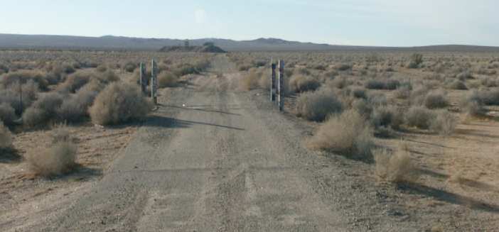
A 2003 photo by Tim Tyler of the road which leads to the former SLFCS radio facility at Hawes.
Tim reported, “The site is accessed off of Highway 58.
The first 100’ or so of the access road is 2 lanes & nicely paved, but then from that point on, it’s a dirt road."
A 2003 photo by Tim Tyler of the remains of a shack at Hawes.
A 2003 photo by Tim Tyler of the base of the former SLFCS radio facility at Hawes.
Tim Tyler reported in 2003, "The earth-covered blockhouse building is intact,
with all internal & exterior doors open (or missing).
One of the 3 diesel engines is still in the power plant room, yet somehow,
someone within the past year or so has been able to lift off the top half (which must weigh at least 2, 000 pounds)
and set it down on the ground, apparently to gain access to the cam shaft or other internal pieces.
Most of the rooms in the earth-covered bunker are covered with graffiti, and have been subjected to fires.
No obvious signs of what the rooms were used for, other than the generator room,
decontamination chamber, helix room at the base of the antenna area,
latrine, and what seems to have been a kitchen area.
Much of the large ventilation ducting is still in place on the ceilings,
some electrical panel boxes and metal conduit are intact, but with the wiring removed."
Tim continued, "There are some major hazards at the site -
holes on the roof from debris falling when the tower was dynamited
and penetrating through the approximately 1 foot of soil & then 1 foot of steel reinforced concrete ceiling.
I’ve been wanting to see this site for over a decade now,
but shame on our government for creating this attractive nuisance.
The tower guy wire cement anchors are still out in the field surrounding the site,
and there are small lengths of guy wire remains around the blockhouse."
A 2003 photo by Tim Tyler of the remains of pavement at Hawes.
Could this be a remnant of the former airfield, or the Hawes Radio facility?
Tim Tyler observed, "The grounds are a former WW2 era Hawes Auxiliary Airfield #1,
but I saw no traces of this mission on the grounds
while heading to/from the Survivable Low Frequency Communications System site,
nor while standing on the top of the SLFCS blockhouse.
I understand that for some reason, the runways were removed, even though the field is out in the middle of nowhere.
It was probably done during the SLFCS days,
to prevent curious pilots from flying in the vicinity of the 1,200’ tower and guy wires to ‘inspect’ the former airfield."
Tim continued, “Hawes is pretty much a non-existent community,
though I did pass a Hawes Creek while on Highway 58,
about a mile or 2 away from the turnoff into the SLFCS site.
I understand that the Army Corps of Engineers is now in the final stages
of contracting for the demolition of the site & the sister facility in Silver Creek, Nebraska.”

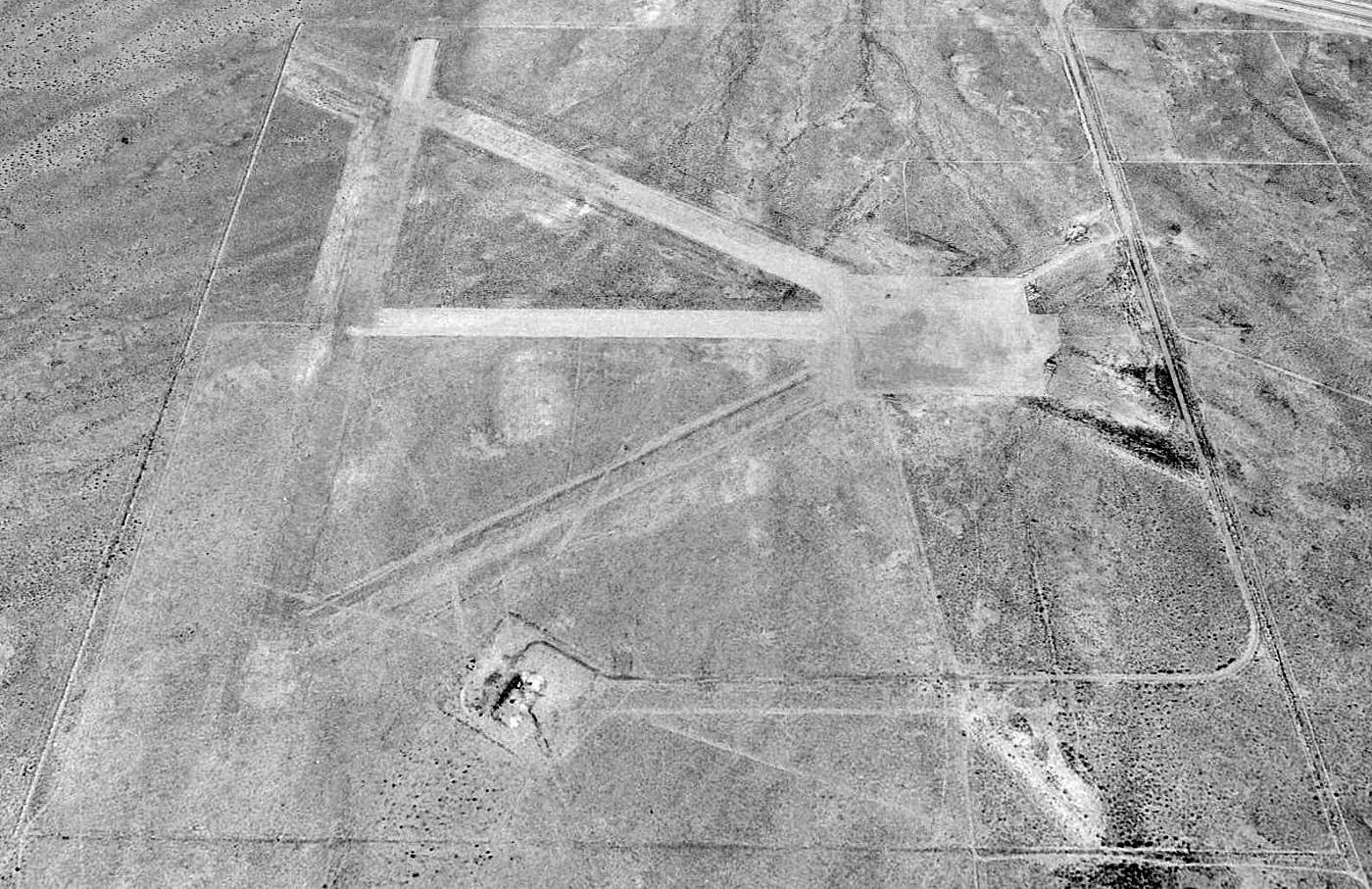
A January 2007 aerial view by Vince Osburn, looking northwest at the Hawes runways.
The remains of the radio site were visible on the southern portion of the airfield.
Greg Loskorn reported, “I went out to the Hawes site to get some more pictures (January 23, 2010)
and the bunker has been completely removed & the ground smoothed over.
Google Earth's recent photos confirm this.
The large concrete guy wire anchors are still scattered throughout the surrounding area though.
Too bad, I wanted to get some more pictures with a better quality camera before it was demolished.”
Lyle Abel recalled in 2011, “I returned a few years ago & was sad to see the tower laying around on the ground in pieces.”
A 2015 aerial view looking north at the remains of the Hawes runways & its radio tower site.

An amazing 11/13/16 aerial view by John Pflughoft looking west at the remains of the Hawes Auxiliary Airfield, taken from his Yuneec Q500 4k drone.
Thanks to Walt Witherspoon & Paul Hirose for information about Hawes.
____________________________________________________
Helendale Auxiliary Army Airfield #2 / Helendale Airport, Helendale, CA
34.82, -117.3 (East of Palmdale, CA)

A 1942 aerial view of the Helendale airfield (courtesy of Bob Anderson).
Photo showing the airfield while in use has not been located.
This airfield was established in 1942 as a satellite field for Victorville AAF (later renamed George AFB).
The earliest depiction which has been located of the Helendale airfield
was a 1942 aerial view (courtesy of Bob Anderson).
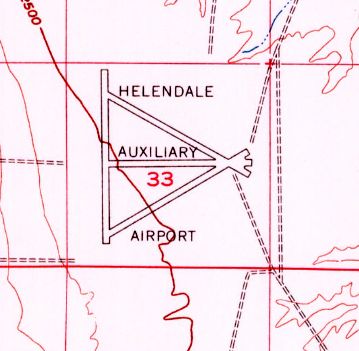
It depicted the field as having 4 paved runways laid out in a triangular configuration.
It was depicted as "Helendale #2" on the 1944 LA Sectional Chart (courtesy of John Voss).
The 1944 US Army/Navy Directory of Airfields (courtesy of Ken Mercer)
described "Helendale Aux. #2, Army" as having a 5,600' hard-surface runway,
and the remarks included, "Auxiliary to Victorville AAF."
Helendale continued to operate as a satellite field for Victorville AAF until the end of WW2.
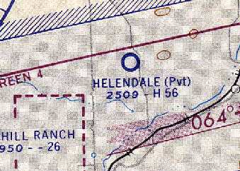
Helendale was reused after WW2 as a private civilian airfield.
Helendale Airport, as depicted on the 1948 USGS topo map.
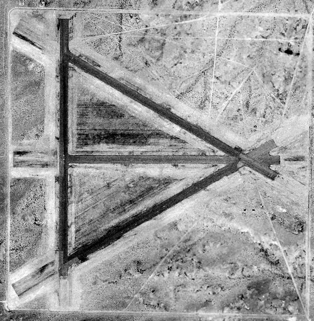
A 6/1/52 USGS aerial photo depicted Helendale as having 4 asphalt runways, but did not show any sign of recent usage.
The 1956 USGS topo map depicted Helendale Auxiliary Airport as having 4 paved runways.
The 1960 LA Sectional Chart (courtesy of Chris Kennedy)
depicted Helendale as a private airfield having a 5,600' hard-surface runway.
It was listed among active airports in the 1962 AOPA Airport Directory,
with a single 3,600' paved runway, but with the note "Closed to public".
A 1964 aerial view (courtesy of Bob Anderson)
depicted Helendale as being basically unchanged from its depiction in 1942,
with 4 paved runways laid out in a triangular configuration.

Helendale was depicted as an active airfield on the 1967 LA Sectional Chart (courtesy of Chris Kennedy).
Strangely, it was not labeled as a private airfield on the 1967 Sectional,
but the remarks block in the Aerodromes table says "Land at pilots own risk."
It was described as having 4 runways, with the longest being a 4,459' asphalt strip.
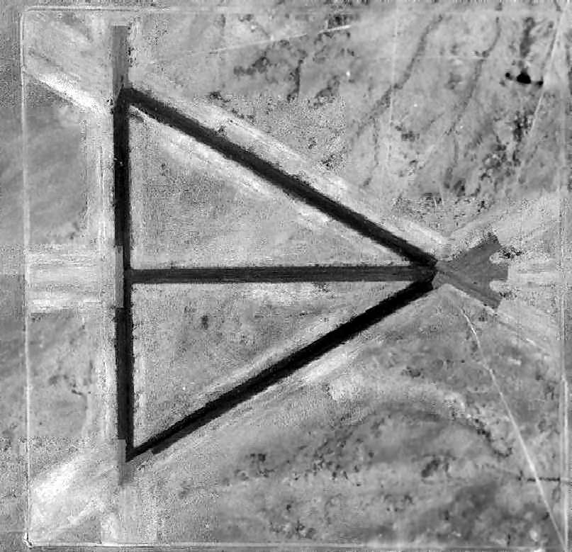
A 1972 aerial view showed the Helendale airfield to remain in fairly decent shape.
Starting in 1983, the runways of this WW2-era airfield were reused
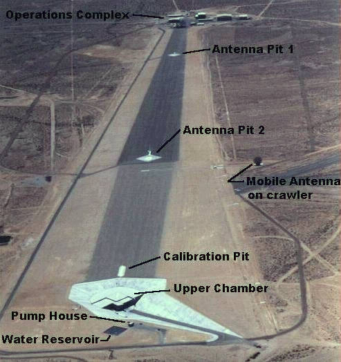
as a radar cross section testing range by Lockheed.
It was the most mechanically sophisticated of the Mojave Desert RCS ranges, and was expanded in 1985.
Its official name was the Helendale Avionics Facility
and was owned & operated by the Lockheed Martin Skunk Works.
One of the 3 paved runways (4/22, 4,600') of the old airstrip was still maintained & operational,
and had lighting for night operations.

The 1994 USGS aerial photo showed the runways of the Helendale's airfield on the northwest & the Helendale RCS range on east side.
A 1996 aerial view looking south along the Hawes radar test range.
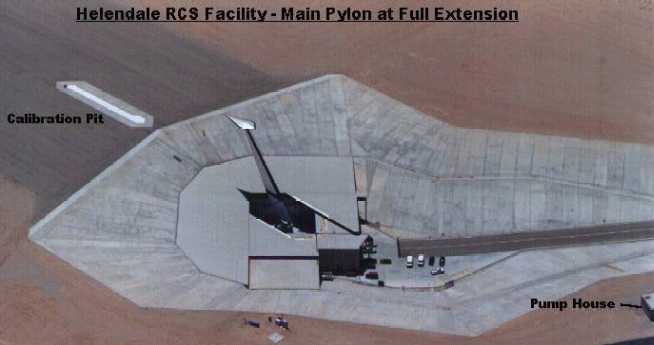
Close-up of the main pylon, used for mounting stealth aircraft shapes for RCS testing
(note generic stealth aircraft shape mounted on top).
The pylon is actually retractable, into a giant silo beneath,
to conceal aircraft configurations from reconnaissance satellites passing overhead.

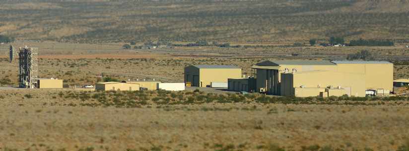
A 2003 photo by Tim Tyler of the hangars & buildings at the Helendale facility.
Tim reported that it consisted of a "Large, open area, with no signs of life -
two large mesh microwave dishes on pedestals.
Both were horizontal, one pointed north, the other pointed east.
Several small & large cream colored buildings are also on the site.
I was able to see the facility for quite a while as I headed south on Helendale Road.
I’m assuming the gated entrance I saw off Helendale Road is not used much.
Helendale Road is dirt, and very bumpy.
No signs of any people or activity."
He added that signs along the fence said "No Trespassing. Lockheed Corp." in an old looking font.

A 2003 photo by Tim Tyler of the remains of a runway at Helendale.

A December 2004 aerial photo by Ando Hiroshi looking northwest at the Helendale RCS range & the runways of the airfield.
A 2005 photo by Joshua Nyhus of the front of the Helendale facility buildings.
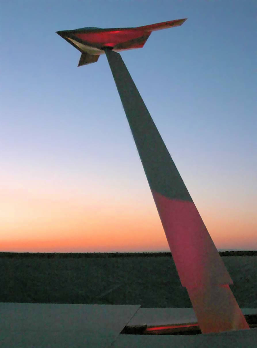
An undated photo from a 2005 press release showing Lockheed Martin's pole model of the X-47B unmanned combat aircraft
mounted & in position for testing as the sun sets at the Helendale Measurement Facility.

A 12/22/14 photo by Shannon Stimmel of the Helendale facility buildings.
The Helendale AAF site is located 5 miles north of Helendale & just west of the Mojave River.
It has a site address of 17452 Wheeler Road, Helendale CA 92342.
Thanks to Walt Witherspoon for information about Helendale.
____________________________________________________
Since this site was first put on the web in 1999, its popularity has grown tremendously.
That has caused it to often exceed bandwidth limitations
set by the company which I pay to host it on the web.
If the total quantity of material on this site is to continue to grow,
it will require ever-increasing funding to pay its expenses.
Therefore, I request financial contributions from site visitors,
to help defray the increasing costs of the site
and ensure that it continues to be available & to grow.
What would you pay for a good aviation magazine, or a good aviation book?
Please consider a donation of an equivalent amount, at the least.
This site is not supported by commercial advertising –
it is purely supported by donations.
If you enjoy the site, and would like to make a financial contribution,
you
may use a credit card via
![]() ,
using one of 2 methods:
,
using one of 2 methods:
To make a one-time donation of an amount of your choice:
Or you can sign up for a $10 monthly subscription to help support the site on an ongoing basis:
Or if you prefer to contact me directly concerning a contribution (for a mailing address to send a check),
please contact me at: paulandterryfreeman@gmail.com
If you enjoy this web site, please support it with a financial contribution.
This site covers airfields in all 50 states.