
Abandoned & Little-Known Airfields:Thompsonw
California: Western Riverside County
© 2002, © 2016 by Paul Freeman. Revised 10/28/16.
This site covers airfields in all 50 states: Click here for the site's main menu.
____________________________________________________
Please consider a financial contribution to support the continued growth & operation of this site.
Calimesa Airport (revised 3/1/12) - Lake Mathews Airport (revised 10/28/16) - Murrieta Hot Springs Airport (revised 3/1/12) - Norconian Club (revised 10/14/07)
Rancho California Airport (revised 10/18/15) - Thompson Field / Bear Creek Airport (revised 10/18/15)
____________________________________________________
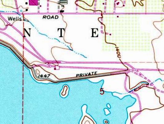
Lake Mathews Airport (52CA), Lake Mathews, CA
33.853, -117.427 (East of Los Angeles, CA)
The 1988 USGS topo map depicted the single paved east/west runway, ramp, and hangar of Lake Mathews Airport, but without any label.
Not much is known about the small private airfield, including its purpose.
Lake Mathews Airport was evidently established at some point between 1982-88,
as it was not yet depicted on the 1982 USGS topo map.
The earliest depiction which has been located of Lake Mathews Airport was on the 1988 USGS topo map.
It depicted the single paved east/west runway, ramp, and hangar of Lake Mathews Airport, but without any label.

The earliest photo which has been located of the Lake Mathews Airport was a 1994 USGS aerial view looking southeast.
It depicted Lake Mathews Airport as having a single asphalt east/west runway,
with a ramp & a small\ hangar on the southwest side of the runway.

The 1997 USGS topo map depicted the single paved east/west runway, ramp, and hangar of Lake Mathews Airport, but labeled it simply as “Landing Strip”.

A 2009 aerial view looking southeast depicted the Lake Mathews Airport runway being marked with “R” (as a private airfield).

The only aeronautical chart depiction which has been located of the Lake Mathews Airport was on the 2009 LA Terminal Aeronautical Chart.
It depicted Lake Mathews Airport as a private field having a 3,300' unpaved runway.
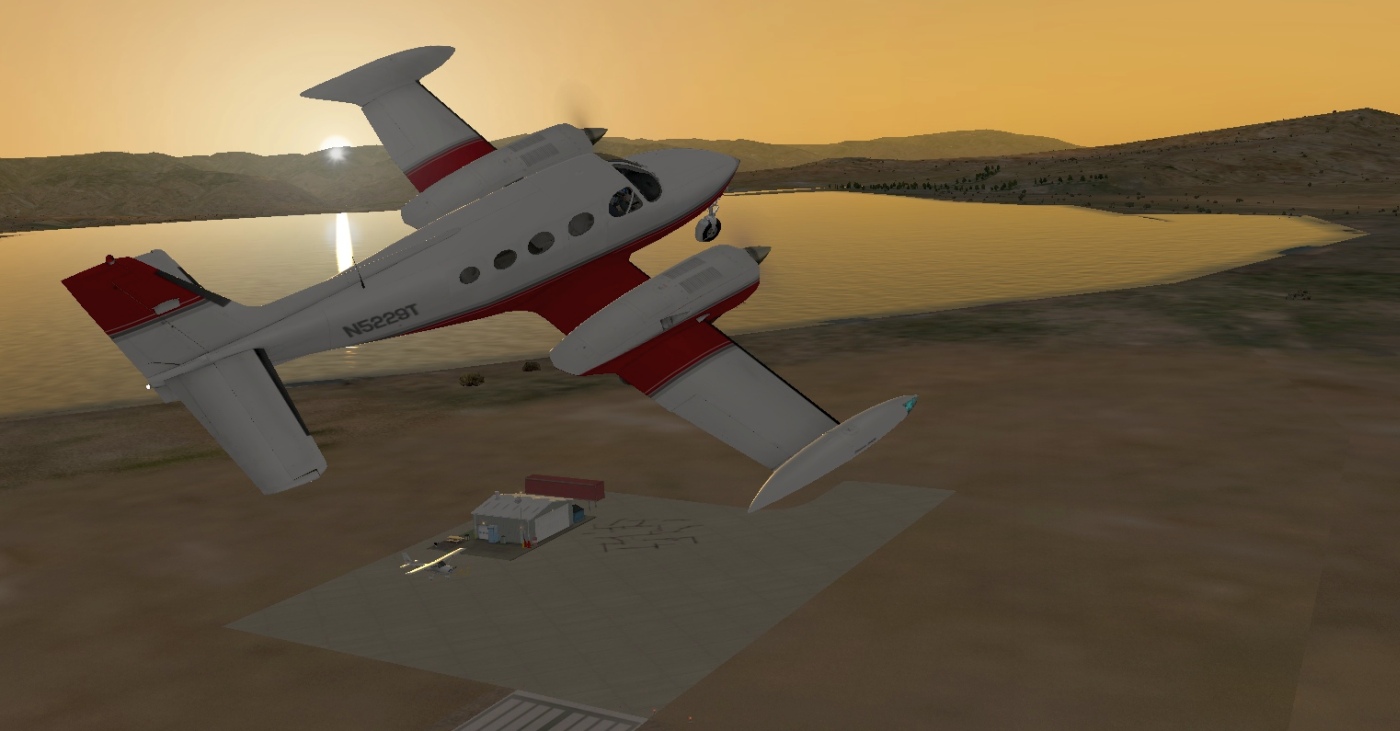
A flight simulator scenery depiction looking southwest at a Cessna 414 overflying the Lake Mathews Airport ramp & hangar at sunset.
The Lake Mathews Airport was evidently closed (for reasons unknown) by 2010, as the runway was marked with yellow closed-runway “X” symbols.

A 2016 aerial view looking southeast showed the Lake Mathews Airport runway & hangar remained intact, but the runway was being used to store unidentified objects.
Lake Mathews Airport is located southeast of the intersection of El Sobrante Road & McAllister Street.
____________________________________________________
Calimesa Airport, Calimesa, CA
33.97 North / 117.05 West (East of Los Angeles, CA)
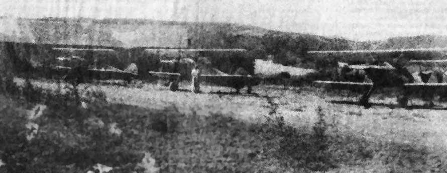
A 1946-47 photo (enhanced by Bill Grasha) of the Surber brothers' 3 Stearman biplanes at Calimesa Airport.
The Calimesa Airport was not yet depicted among active airfields in the 1945 AAF Airfield Directory (courtesy of Scott Murdock)
nor depicted on the 1945 San Diego Sectional Chart (courtesy of John Voss).
According to Mike Berry, “Vi [Violis] Surber lived on the property with his wife & 4 children before there was a field there
and the property was owned by the local water district.
Vi asked permission & they let him mow the field & let him put the runway in.
It was 1945 when Vi started the field. He & his family maintained the field.
The house they lived in was a old Stage Coach way back.”
According to an article in the 4/3/91 issue of the Yucaipa & Calimesa News-Mirror (courtesy of Mike Berry),
two brothers, Violis & Pete Surber, established an airfield in the 1940s on land belonging to the water district.
The barn on the property became a hangar,
and the 2 brothers bought junked aircraft & rebuilt them.
Aircraft operated from Calimesa included Stearmans, Cessnas, and Fairchilds.
Violis Surber registered the airfield with the FAA in 1945.
Mike Berry reported, “My father got out of the Army in 1946 & that's when he started flying out of Calimesa.
He owned a few different airplanes with Violis Surber & Rufus Biddix. They had a PT-17 Stearman & a PT-19. They also had a Luscombe.
My Dad was Jack Berry & he met my Mom in 1949 & their first date was in the Stearman.
My father had a wonderful time in those days & met many people that became friends.”
The earliest depiction of Calimesa Airport which has been located
was a 1946-47 photo of the Surber brothers' 3 Stearman biplanes at Calimesa Airport.

A 1948 aerial photo (from Riverside Flood Control, courtesy of Mike Berry, (enhanced by Bill Grasha)
depicted Calimesa Airport as having a single unpaved southeast/northwest runway,
with a few small buildings on the northwest & north side of the runway.

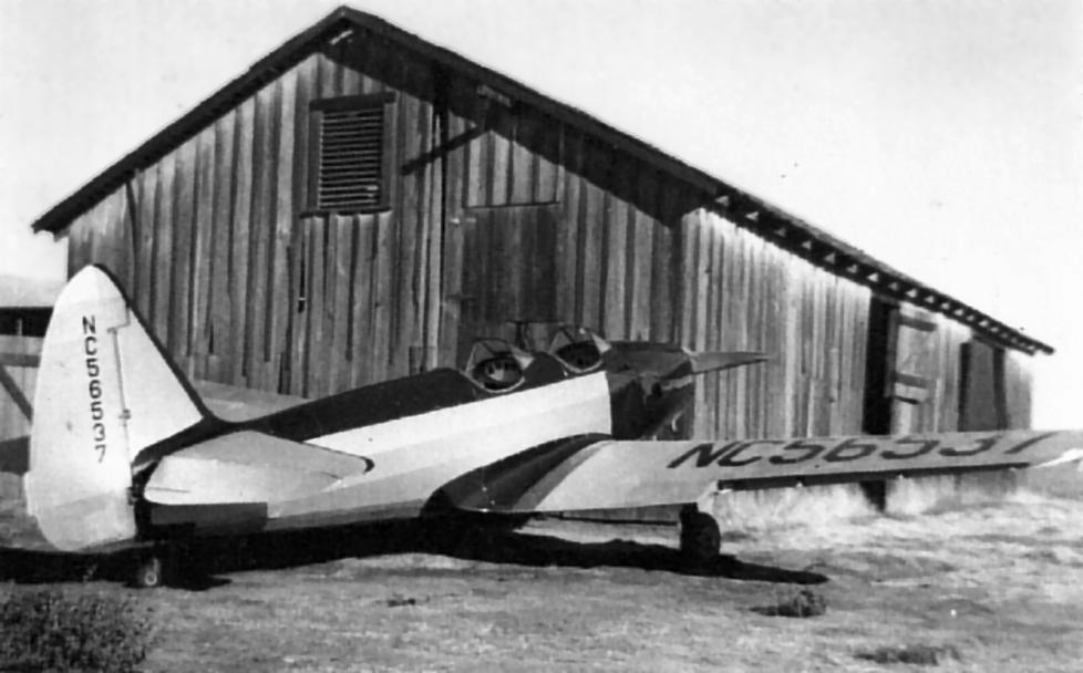
A circa 1940s photo of Calimesa Airport founder Vi Surber with his wife Mary & daughters Rosie & Sharon in front of a Fairchild PT-19 (courtesy of Mike Berry, (enhanced by Bill Grasha).
A circa 1940s photo of a surplus PT-19 in front of a barn at Calimesa Airport (courtesy of Mike Berry, (enhanced by Bill Grasha).
According to Mike Berry, “Those barns were 90 years old back in the 1940s.”

A circa 1940s photo of a Stearman biplane at Calimesa Airport (courtesy of Mike Berry, (enhanced by Bill Grasha).

A circa 1940s photo of a group in front of a Stearman at Calimesa Airport (courtesy of Mike Berry, (enhanced by Bill Grasha).
Mike reported, “My Dad [Jack Berry] is the 2nd from the right. He & the fellow to his right owned the PT-17 Stearman.”
According to an article in the 4/3/91 issue of the Yucaipa & Calimesa News-Mirror (courtesy of Mike Berry),
Calimesa was used for flight training, and also for aerial photography using a Stearman biplane.
The Surber family moved off the airport land in 1950, which made maintaining the strip more difficult.
The airport's heyday ended in 1953 when the expense of operating the aircraft became too great.

The 1953 USGS topo map depicted the Calimesa Airport as having a single northwest/southeast runway, with several small buildings on the west & north sides.

The only aeronautical chart depiction which has been located of the Calimesa Airport was on the 1955 San Diego Sectional Chart.
The Aerodromes table described as having a 1,700' clay runway.
Mike Berry reported of his father's flying from Calimesa Airport: “The last entry in his logbook was in 1956.”
According to an article in the 4/3/91 issue of the Yucaipa & Calimesa News-Mirror (courtesy of Mike Berry),
Calimesa Airport founder Violis Surber was killed by a drunk driver in 1957.
According to his daughter Rosie Adams, “He flew all those years, and then was killed on a freeway.”
The date of Calimesa Airport's closure has not been determined, but it was presumably shortly after 1957.
According to Mike Berry, Calimesa Airport “closed in 1957 or so.”
Sharon Lewis (daughter of Calimesa Airport founder Violis Surber) recalled,
“The airstrip always gave me a love of airplanes.
The airplanes were pure entertainment, and the camaraderie of the men who flew them,
the way they would talk & describe the way they flew, is something I will always remember.”
Surber's other daughter, Rosie Adams, recalled,
“I didn't realize how unique our airstrip was.
It wasn't until I was older that I realized everybody doesn't have an airport.”
A 1959 aerial view showed that the runway was no longer discernible – replaced by a farmed field.
The building on the north side of the runway had been removed at some point between 1948-59,
but the buildings on the northwest side still remained.
A 1967 aerial view showed that the buildings on the northwest side of the runway had been removed at some point between 1959-67.

A 1991 newspaper photo (courtesy of Mike Berry, (enhanced by Bill Grasha) of a windsock pole & frame – all that remained of Calimesa Airport.

A 11/16/09 aerial view no longer depicted any trace of Calimesa Airport, but the site remained an open field.
The site of Calimesa Airport is located west of the intersection of Roberts Road & Cherry Valley Boulevard.
____________________________________________________
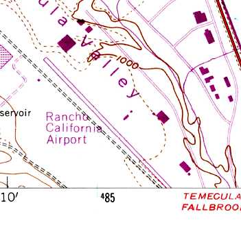
Rancho California Airport (2L0), Temecula, CA
33.5 North / 117.16 West (North of San Diego, CA)

The earliest depiction which has been located of the Rancho California Airport was a 1967 aerial view.
A 1947 aerial view did not yet depict any sign of an airfield at this location.
According to a report prepared by Anne Miller for the Temecula Valley Historical Society,
“In the mid-1960s, the LA Times began running large advertisements about Rancho California,
a new 87,000-acre planned community in the Temecula Valley.
In the Times on November 6, 1966, there was a photograph that showed a helicopter 'towing' an antique plow
at the groundbreaking of the Rancho California Airport.”
According to the report by Anne Miller, “Bill Harker flew into he airport in the early years.
He reported that the first time he landed there,
it was just a 1,200' gravel strip with one hangar, a small office, and a few planes tied down.
He was told that the airport was originally graded by some of the contractors
who were building the original Ranch California Plaza (now Tower Plaza)
because they commuted by plane to the job site.”
The earliest depiction of Rancho California Airport which has been located was a 1967 aerial photo,
It depicted the airport with a single paved runway & at least one paved taxiway.
There did not yet appear to be any hangars or other buildings at the airfield,
and there also did not yet appear to be any aircraft based at the field.
According to K.O. Eckland, Rancho California Airport
was described in a 1968 Jeppesen Airport Directory as having a 3,465' paved runway.

Rancho California Airport,
as depicted on the September 1971 USAF Tactical Pilotage Chart (courtesy of Chris Kennedy).
The 1973 USGS topo map depicted the Rancho California Airport as having a single northwest/southeast paved runway,
with a few small buildings along the east side.
According to the report by Anne Miller, “When Bill Harker flew into Rancho California Airport again in 1974,
it had been lengthened & paved.
He noted that the Unicom transceiver was located in the office of the old Rancho Inn
in the old Plaza on the edge of the pond (where the Tower Plaza is located today).”

A 1976 aerial photo of a portion of the Rancho California Airport
depicted the field as having a single paved runway,
with several paved taxiways leading to hangars.
At least 2 small aircraft were visible parked on the field.
Rancho California Airport was listed among active airports in the 1977 Pilot's Guide to CA Airports (according to Chris Kennedy).
The last photo which has been located of the Rancho California Airport was a 1978 aerial view.
It depicted a dozen light aircraft parked on the field.

The last aeronautical chart depiction which has been located of Rancho California Airport as still operational
was on the January 1979 LA Sectional Chart (courtesy of Mitchell Hymowitz).
It depicted “Rancho” Airport as having a 3,500' paved northwest/southeast runway.

The 1979 USGS topo map depicted the Rancho California Airport as having a single northwest/southeast runway,
with a few small buildings along the east side.
Rancho California Airport was described in the 1982 AOPA Airport Directory (courtesy of Ed Drury)
as having a single 3,000' asphalt Runway 12/30.
The operators were listed as Airmech Industries & Rancho Aviation.
It was still depicted as an active airfield on the 1987 CA Aeronautical chart,
with a single 3,500' paved runway.
In 1987 Rancho California was the site of a hard landing accident by a Beechcraft Bonanza,
in which turbulent crosswinds were identified as a contributing factor.
According to the report by Anne Miller, “In 1989 Rancho California Airport was closed
just a week after the new French Valley Airport opened.
Don Vierta noted that he was the last one to fly out of Rancho California as he moved his plane to French Valley.
The hangars from the old airport were later moved to French Valley.”
Tom Kramer noted, “The airport was closed due to it being in the middle of the town.
However, its closure was linked to the opening of one of the few new airports
in Southern California in the last few decades, French Valley Airport, just up I-215.”

Rancho California Airport was still depicted on the 1989 San Diego Terminal Area Chart (courtesy of Chris Kennedy),
but it was labeled "Closed".
The 1996 USGS aerial photo of the site showed that the property had been redeveloped,
and not a trace appeared to remain of the former airport.
A new road, Business Park Drive, had been built over the former runway area.

A circa 2001 aerial photo of the site of the former airport.
Chris Kennedy reported in 2003, "I have visited this site on the ground & found nothing."
The airport site is located northwest of the intersection of Interstate 15 & Rancho California Road.
____________________________________________________
Murrieta Hot Springs Airport, Murrieta, CA
33.56 North / 117.2 West (North of San Diego, CA)

Murrietta Hot Springs Airport,
as depicted on the 1953 San Diego-San Francisco Flight Chart (courtesy of Scott O'Donnell).
This little airport was apparently opened at some point between 1951-53,
as it was not yet depicted on the March 1951 San Diego USAF Sectional Aeronautical Chart (courtesy of Chris Kennedy)
nor on the 1953 USGS topo map.
The earliest reference to the airport which has been located
is the 1953 San Diego-San Francisco Flight Chart (courtesy of Scott O'Donnell)
which described the field as having an unpaved 2,200' runway.
Murrieta Hot Springs Airport was listed among active airports in the 1962 AOPA Airport Directory,
which described the field as having a single unpaved 2,200' Runway 9/27.
The Murrieta Hot Springs Airport may have closed as a public airport by 1966,
as it was no longer depicted at all on the 1966 San Diego Sectional Aeronautical Chart (courtesy of Chris Kennedy).
It was eventually replaced by the newly constructed Murrieta Temecula Airport, a few miles southeast.

The earliest photo that has been located of the Murrieta Hot Springs Airport was a 1967 aerial view.
It depicted the field as having a single unpaved northeast/southwest runway.
A few small buildings were on the northwest side of the runway,
and 6 light aircraft were parked on the southeast side of the field.

Murrieta Hot Springs Airport was labeled simply as "Landing Strip" on the 1973 USGS topo map.
It was depicted as having a single unpaved northeast/southwest runway,
with a few small buildings along the west side of the field.
The last photo which has been located showing the Murrieta Hot Springs Airport while in operation was a 1978 aerial view.
A single light aircraft was visible on the field.

Murrieta Hot Springs Airport was labeled simply as "Landing Strip" on the 1979 USGS topo map.
It was depicted as having a single unpaved northeast/southwest runway,
with a few small buildings along the west side of the field.
Tom Kramer recalled, “When I used to drive up Interstate 15, if you knew just when to look,
you'd see a few aircraft parked there with a hangar or two.
I do recall seeing a large piston engine passenger type aircraft there back in the 1980s.”
Lane Leonard reported, “I flew into there only once from the Lake Riverside Airport.
The large aircraft was a 4-engine De Havilland Heron.
Green & white with opposed engines & not Rangers.
The Heron was parked on the northwest corner of the airport & was visible from the freeway.
At that time I wondered about balanced field length with that type of aircraft.
Where the construction equipment is now located is where it was parked.
I never got to see it fly but one day driving by it looked like a large party of around 8 was preparing to board it.
It was there for about 6 months & then suddenly it was gone.”

As depicted in the circa 2000 aerial photo,
the airfield consisted of a 3,500' asphalt runway, an asphalt ramp north of the west end of the runway,
and several small buildings & hangars.
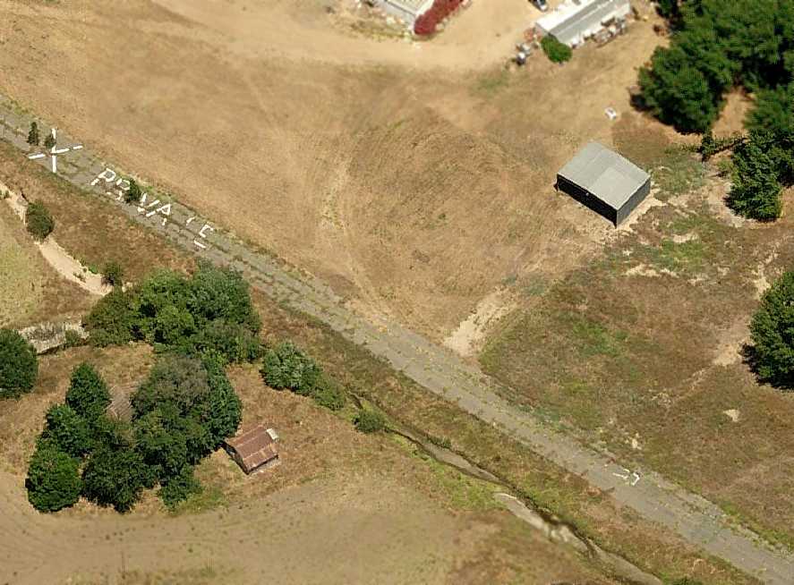
The airfield still exists largely intact, but is now surrounded by houses,
which was probably the reason for its closure.
Chris Kennedy reported in 2003, "I went by the Murietta Hot Springs Airport
and it looks pretty much like the [above] aerial photo,
although there are For Sale signs along the runway."

A Fall 2006 panoramic shot by Chris Davis of the Murietta Hot Springs Airport.
Chris observed, “the reason the airstrip V's is the distance from which I took the 180 degree shot (very close).”
A circa 2007 aerial view looking east at the remains of the Murietta Hot Springs Airport,
showing the runway pavement still marked with “X Private” & a remaining hangar.

A July 2009 aerial view by Woodrow Anselen looking southeast along the remains of the Murrietta Hot Springs runway.
Woodrow reported, “Its a funny thing; I have been flying this same area for 36 years,
and was never even aware there existed a Murrietta Hot Springs Airport until I saw it on your website.
By using your descriptions I was able to locate it, and flew out there last week;
the airstrip is only some 12 minutes flying time from my home airport (Corona, CA).
The runway is still plainly visible & generally intact.
On the northeastern end, however, you can see some very substantial trees growing right through the pavement.”

A July 2009 aerial view by Woodrow Anselen looking west at the former hangars & runway at Murrietta Hot Springs.
The airport site is located east of the intersection of Los Alamos Road & Monroe Avenue.
____________________________________________________
Thompson Field / Bear Creek Airport (L86), Murrieta, CA
33.57 North / 117.24 West (North of San Diego, CA)
Thompson Field, as depicted on the January 1979 LA Sectional Chart (courtesy of Mitchell Hymowitz).
This general aviation airfield was apparently built at some point between 1967-78,
as it was not depicted on the 1966 San Diego Sectional Aeronautical Chart (courtesy of Chris Kennedy)
nor depicted on a 1967 aerial photo.
The earliest reference to the field which has been located
was in the 1978 Pilot's Guide to CA Airports (according to Chris Kennedy),
which listed it in the "Unattended Airports" section as the "Thompson Transportation Center".
It was described as having a single 2,700' dirt Runway 15/33.
The earliest depiction which had been located of Thompson Field was a 1978 aerial photo.
It depicted the field as having a single unpaved northwest/southeast runway.
Two very small buildings were on the southeast side of the field, along with 4 light aircraft.
The earliest aeronautical chart depiction which has been located of Thompson Field
was on the January 1979 LA Sectional Chart (courtesy of Mitchell Hymowitz).
It depicted Thompson Field as having a 2,800' unpaved runway.
According to Bob Butt, "About Thompson Field - It was owned by Curt Thompson a local farmer.
Several of the farmers would come & sit in some old couches under the oak trees in the evenings & drink beer.
They had a pile about 5' high.
The runway was surrounded by the wild wheat that Curt would harvest & bail as feed.
I did my early flight training there in a Taylorcraft & a C-140
and we would go to the Temecula airport for fuel.
When Skylark airport flooded, the skydiving operation moved there until the waters receded.
The DC-3's are still owned & operated by the same person, they are at Skylark (Elsinore).
The last one to fly out of there landed at Skylark & has not flown since."
Bob Cannon recalled, "Thompson Field… I did all of my test flying for my banner tow mechanism there.
I believe [the owner's] name was Carl. He offered me the entire property for $1M.
The new Jack Nicklaus golf course nearby ran a large paved road right up to mid-field where their property ended.
I think they fully intended to buy the property eventually.
It was a fun place where one could also do some target shooting & have a picnic."

A 1982 aerial view depicted Thompson Field as having a single northwest/southeast runway.
A few very small buildings were on the southeast side of the field.
A total of 15 aircraft were visible on the field,
including several gliders, and what appears to be an aircraft towing a glider on the runway.
It was listed as "Thompson Transportation Center" in the 1982 AOPA Airport Directory (courtesy of Ed Drury),
with a single 2,800' dirt Runway 15/33,
and the operator listed as Skylark Gliderport.
In its last few years it was used for parachuting & ultralight aircraft operations.

Thompson Field was depicted as an active airfield on the 1989 San Diego Terminal Area Chart (courtesy of Chris Kennedy),
with a 2,700' unpaved runway.
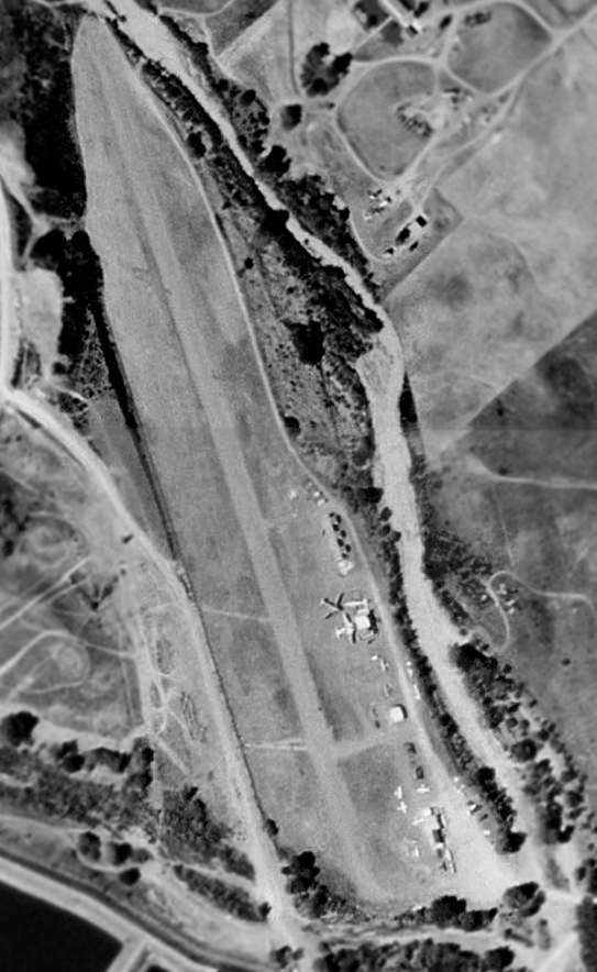
In a 1996 USGS aerial photo (enhanced by Bill Grasha), a total of 10 aircraft were visible parked outside, including three DC-3s!
One of those DC-3s was the last aircraft to fly out of the airport before its closure.
In addition to the single dirt runway, the airfield had several small buildings & hangars along the east side.
In its later years, the airfield was known as Bear Creek Airport.
Bear Creek Airport closed in 1997.
It eventually was surrounded by housing developments, which was most likely the reason for its closure.

In the June 2002 USGS aerial photo (enhanced by Bill Grasha),
the runway & airport buildings were still completely intact, just devoid of any aircraft.
Jere Vandewalle reported, “Aunt Lucy claims that as recently as 2002 (when she moved in) there were light aircraft operating there,
and since she saw lots of both kinds, I think she knows the distinction between those & ultralights.
There is still lots of traffic in the area & I wouldn't be surprised if landings continued after the closure for some time.”
According to Bob Butt, "Curt fought the city council over the construction of a bridge too close to the end of the runway
but although he won a judgment the bridge is still there.
When he died his brother did not have the strength to fight the city council
and sold it in 2002 or 2003 but it was actively in use by ultralights until the summer of 2003.
The post for the deposit of the landing fee is still there.
The buildings are being sold, dismantled, and moved."
Chris Kennedy reported in 2003, "I went by the Bear Creek Airport last week & it is still there,
although fenced & inaccessible.
There are houses up to within a hundred yards or so of it to the east."

A 2005 photo by Chris Kennedy (enhanced by Bill Grasha), taken just west of the bridge, looking South-Southeast at the former Bear Creek Airport.
The runway is still visible, as well as one former hangar.
Anne Miller reported in 2005, “Any evidence of the old runway is 'fading away'
and the site surrounded by new homes.
The high Calle Del Oso Oro bridge across the Murrieta Creek just off the north end of the runway virtually ended flying there.
The last DC-3 must been broken down & hauled out.”

A 2005 photo by Jere Vandewalle (enhanced by Bill Grasha)looking along the remains of the former runway of Thompson Field.
Jere observed, “Standing on the runway it is hard to imagine DC-3s there.”

A 2005 photo by Jere Vandewalle (enhanced by Bill Grasha) looking east at the remains of a former hangar at the site of Thompson Field.

A 2005 photo by Jere Vandewalle looking northwest at ruins in front of a former hangar at the site of Thompson Field.

A July 2009 aerial view by Woodrow Anselen looking north along the remains of the Bear Creek runway.
Woodrow reported, “I used to see a number of airplanes on Bear Creek, and for a while there were even 2 DC-3s based there.
For reasons I cannot understand, I never flew out there & landed; funny thing for me, as the airstrip is only about a 12 minute flight from Corona.
In these pictures you can clearly see the runway, which again seems to be in serviceable, though perhaps not great, shape.
I certainly have landed on worse!
There are no buildings left, but you can still see the remnants of some concrete pads.”
The airport site is located west of the intersection of Magnolia Street & Washington Avenue.
____________________________________________________
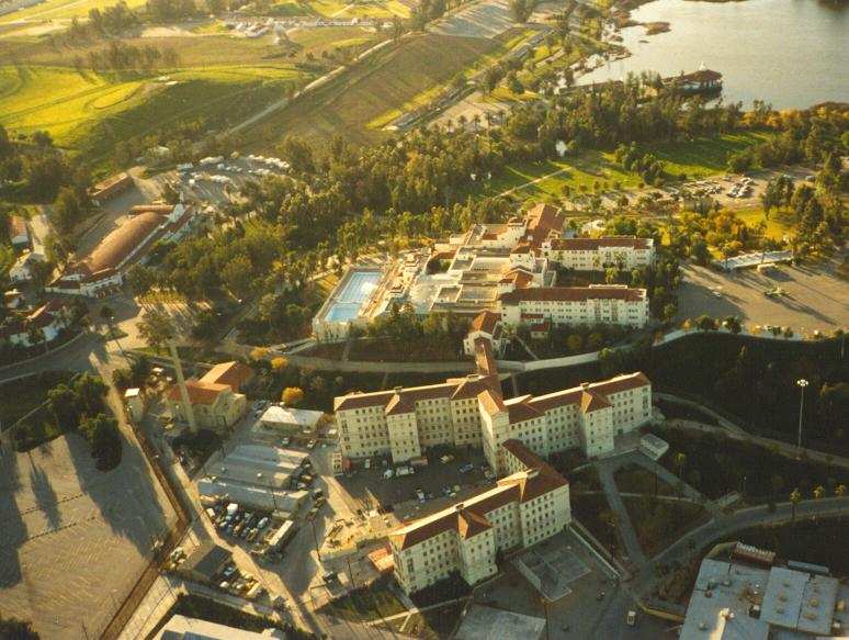
Norconian Club Airport, Norco, CA
33.93 North / 117.57 West (East of Los Angeles, CA)

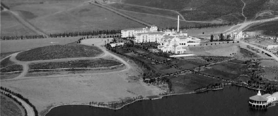
This was once a playground for the rich & famous.
The Norconian Club, a 700-acre luxury resort, was built by Rex Clark in 1928.
Frequented by silent-screen stars, the complex sported a gambling casino, golf course,
55 acre lake, a hot sulfur spring spa, a magnificent 5-story hotel, and its own airport.
Sitting atop a knoll, the hotel had a commanding view of Lake Norconian & the surrounding countryside.
The date of construction of the Norconian Club Airport has not been determined.
The earliest photo which has been located of the Norconian Club Airport was a 1928 photo,
showing a dirt runway with the club buildings in the background.
The earliest listing of the airfield which has been located
was in the Standard Oil Company's 1929 "Airplane Landing Fields of the Pacific West" (courtesy of Chris Kennedy).
It described the Norconian Lake Club Airfield as having 2 dirt runways,
with the longest being a 2,400' east/west strip.
After the stock market crash of 1929, the Norconian resort plunged into a 12-year decline.
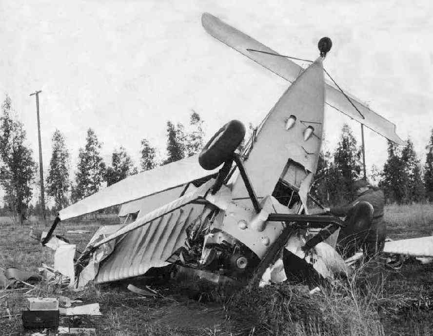
A 1/26/33 photo (enhanced by Bill Grasha) of the fatal crash of Marshal Boggs in an unidentified aircraft at the Lake Norconian Club.
Boggs, an inspector for the Civil Aeronautics Administration, was reported to be the 1st test pilot to use radio navigation.
In the 1930s, Will Rogers was reported to be a regular guest at the hotel, using the airfield to arrive & depart.
Amelia Earhart also used the Norconian air field to practice landings & takeoffs.

The earliest aeronautical chart depiction which has been located of the Norconian Club Airport
was on the 1934 San Diego Sectional Chart (courtesy of Scott O'Donnell).
It depicted “Norconian Club” as an auxiliary airfield.
A 1936 Commerce Department "Descriptions of Airports & Landing Fields in the US" (courtesy of Dan MacPherson)
described the "Norconian Club Field" as having a single north/south sod 2,000' x 400' runway.
The Airport Directory Company's 1937 Airports Directory (courtesy of Bob Rambo)
described Norconian Airfield in the same manner.
A 1938 aerial view depicted a single grass east/west runway on the northern side of the buildings.
It was still depicted as a commercial airfield on the 1939 LA Sectional Chart (courtesy of Jon Karkow).

The last aeronautical chart depiction which has been located of the Norconian Club Airport
was on the 1940 San Diego Sectional Chart (courtesy of Chris Kennedy).
It depicted “Norconian” as a commercial/municipal airport.
Owner Rex Clark eventually agreed to sell the complex to the Navy for $1.6 million in 1941.
The posh former resort was transformed by the Navy into a Naval Hospital.
According to NSWC Coronoa public affairs journalist Marlowe Churchill,
the Corona “runway [was] used in the first aeromedical flights of WWII casualties.”
During WW2, some of the facilities at the Norconian also were used for early guided missile research.
The installation was eventually named the Corona Naval Weapons Center.
A 1948 aerial view showed that the site of the runway had been covered by buildings
(most of which are still on the site as of 2005).
According to Troy Lyman, the site previously occupied by the airfield
was reused by the Navy in the to construct hospital overflow buildings to accommodate patients coming home from overseas.
These buildings were eventually reused as a prison, labeled the California Rehabilitation Center on topo maps.
A 1985 aerial photo by Dan MacPherson looking south at the former Norconian Club.

A circa 2001 aerial photo, annotated by Troy Lyman to show the location of the former Norconian Club runway.
No remains of the former airport were still perceptible.
Troy Lyman reported in 2005, “I have in our possession 2 photos showing the hotel & the old airfield.
The airfield was located just to the north of the hotel.
It would have been located just to the south of what is today 5th Street.”
In 2005, the Navy's Corona Naval Weapons Center was placed on the Base Realignment & Closure Commission list.
However, Tim Alsky reported in 2006 that “I'm happy to say that the Base Realignment & Closure Commission
decided last month that the Naval Surface Warfare Center will NOT be closed after all.
The historical site (former Norconian Club) was spared from the chopping block & will remain fully operational.”
____________________________________________________
Since this site was first put on the web in 1999, its popularity has grown tremendously.
That has caused it to often exceed bandwidth limitations
set by the company which I pay to host it on the web.
If the total quantity of material on this site is to continue to grow,
it will require ever-increasing funding to pay its expenses.
Therefore, I request financial contributions from site visitors,
to help defray the increasing costs of the site
and ensure that it continues to be available & to grow.
What would you pay for a good aviation magazine, or a good aviation book?
Please consider a donation of an equivalent amount, at the least.
This site is not supported by commercial advertising –
it is purely supported by donations.
If you enjoy the site, and would like to make a financial contribution,
you
may use a credit card via
![]() ,
using one of 2 methods:
,
using one of 2 methods:
To make a one-time donation of an amount of your choice:
Or you can sign up for a $10 monthly subscription to help support the site on an ongoing basis:
Or if you prefer to contact me directly concerning a contribution (for a mailing address to send a check),
please contact me at: paulandterryfreeman@gmail.com
If you enjoy this web site, please support it with a financial contribution.
This site covers airfields in all 50 states.