
Abandoned & Little-Known Airfields:
Colorado: Colorado Springs area
© 2002, © 2016 by Paul Freeman. Revised 11/26/16.
The CO pages of this website are sponsored by the Colorado Pilots Association:
____________________________________________________
Please consider a financial contribution to support the continued growth & operation of this site.
Aaardvark Field (revised 5/26/13) - Alexander Airport / Nichols Field (revised 10/1/16)
Black Forest Gliderport (revised 1/30/16) - (Original) Pueblo Municipal Airport (revised 11/26/16)
____________________________________________________
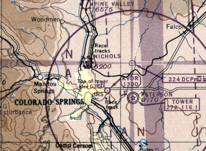
Alexander Airport / Nichols Field, Colorado Springs, CO
38.88, -104.813 (South of Denver, CO)

A 1928 view of the interior of the Alexander Aircraft Company plant.
The Alexander Film Company, under the brothers J. Don & S. Don Alexander, specialized in film advertising.
When the younger J. Don Alexander wanted 40-50 airplanes for his salesmen, he was forced to produce his own aircraft,
as no company at the time was able to fill such an order.
Originally headquartered in Englewood, the film-turned-aircraft company was forced to move to Colorado Springs in order to expand.
The Alexander Aircraft Company built a number of successful versions of the Alexander Eaglerock biplane, which were especially popular with barnstormers.
They were also used for carrying airmail, aerial photography, crop dusting, and air racing.
The earliest depiction which has been located of the Alexander Aircraft plant was a 1928 view of the interior,
showing several aircraft under construction.
For a brief period from 1928-29, Alexander was the largest aircraft manufacturer in the world,
and more aircraft were built in Colorado than anywhere else in the world.

A 5/19/29 photo of Alexander "Bullet" #8228, a low-wing monoplane, at the Alexander Colorado Springs plant.

Financial woes forced the Alexander Aircraft Company into bankruptcy in 1932.
The earliest airport directory listing which has been located of the Alexander Airport
was in The Airport Directory Company's 1937 Airport Directory (courtesy of Bob Rambo).
It described Alexander as a commercial airport, located 3 miles north of Colorado Springs.
The field was said to consist of a 160 acre T-shaped sod field with one oiled 4,200' north/south runway & 2 hangars.

The earliest photo which has been located of Alexander Airport was a 1938 aerial view (courtesy of Jim Densmore).
It depicted the field as having a single northwest/southeast runway, with a few small hangars on the west side.
Across the road to the west sat the facilities of the Alexander Aircraft Company.
The Alexander Airport had evidently closed (for reasons unknown) at some point between 1937-39,
as it was not depicted on the February 1939 Denver Sectional Chart
nor on the March 1940 Denver Sectional Chart.

An undated (1940s?) aerial view looking west at the Alexander Aircraft Company plant & film studios.

At some point between 1940-45, the former Alexander Airport was evidently reopened as Nichols Field,
as that is how it was depicted on the February 1945 Denver Sectional Chart.
It depicted Nichols as an auxiliary airfield.
The last aeronautical chart depiction which has been located of Nichols Field was on the March 1946 Denver Sectional Chart.
It depicted Nichols as a commercial/municipal airport.

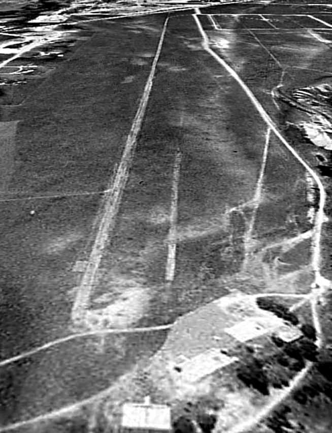
Nichols Field was evidently significantly expanded at some point between 1938-47, as depicted on a 7/25/47 aerial photo.
The original northwest/southeast runway was joined by 2 new runways, oriented northeast/southwest & northwest/southeast,
along with multiple taxiways.
Several buildings were depicted on the west side of the field.
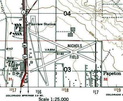
The 1949 USGS topo map depicted Nichols Field as having 3 paved runways, taxiways, and several buildings along the west side.
Nichols Field was evidently closed (for reasons unknown) at some point between 1946-50,
as it was no longer depicted on the April 1950 Denver Sectional Chart.
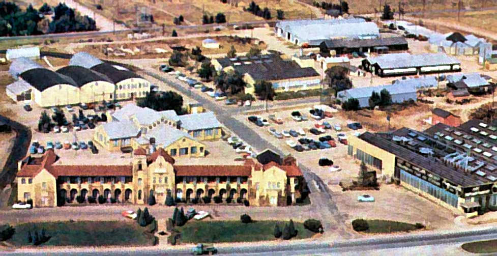
An undated (1950s?) aerial view looking west at the Alexander Aircraft Company plant & film studios.
A 10/24/60 aerial photo showed the Nichols Field site had been covered with new streets & buildings.
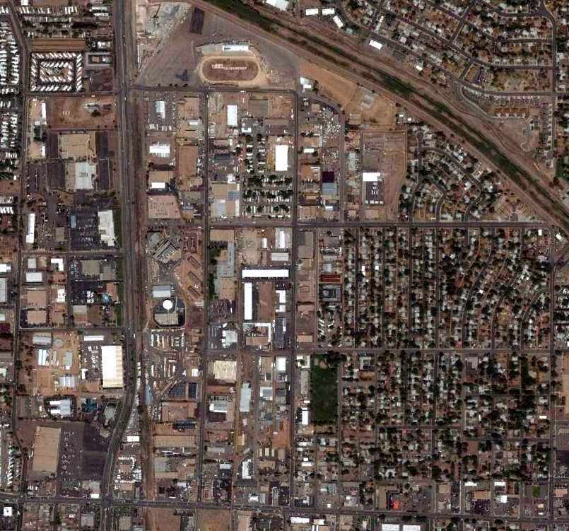
A 6/19/06 aerial photo shows no obvious remaining trace of Nichols Field,
although a few of the buildings used by Alexander Aircraft for manufacturing still remained.

A circa 2008-2011 aerial view looking west showed that a few of the buildings used by Alexander Aircraft for manufacturing still remained,
although their main building had been removed & replaced with a smaller bank building.
It is not apparent if any of the buildings on the west side of the airfield site (in the foreground) were former hangars.

A 2011 photo by Jim Densmore of the former Alexander Aircraft manufacturing buildings.
The site of Nichols Field is located northeast of the intersection of Route 85 & East Filmore Street.
____________________________________________________
Black Forest Gliderport, Black Forest, CO
38.97, -104.68 (South of Denver, CO)

Black Forest Gliderport, as depicted on the December 1968 Denver Sectional Chart (courtesy of Richard Doehring).
This general aviation glider airfield was evidently established at some point between 1962-68,
as it was not yet depicted on the 1962 USGS topo map.
The earliest depiction which has been located of Black Forest Gliderport
was on the December 1968 Denver Sectional Chart (courtesy of Richard Doehring).
It depicted Black Forest as a private field with a 6,000' unpaved runway.
Kevin Shaw recalled, “Black Forest Glider Port was a very active, internationally known location for high altitude wave flying over the nearby mountains.
It was owned by Mark Wild & Dave Johnson, and was most active in the 1960s & 1970s.”
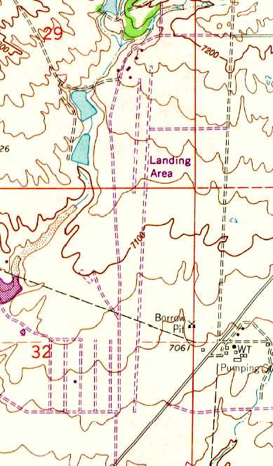
The earliest topo map depiction which has been located of Black Forest Gliderport was on the 1969 USGS topo map,
which a north/south unpaved runway, with several buildings at the north end, labeled simply as “Landing Area”.
The 1970 Denver Sectional Chart (courtesy of Ed Granato)
depicted Black Forest Glider Port as a private field with 2 parallel paved runways, the longest being 6,000'.

A 1972 aerial view looking north by Jim Foreman (courtesy of Mark Hess) depicted Black Forest as having a pair of parallel asphalt runways,
one of which was marked Runway 7, the other with an X.
Fifteen aircraft were visible on the field, including both gliders & single-engine aircraft.
The hangars were marked with “Black Forest” & “Glider Port” & the Unicom frequency.
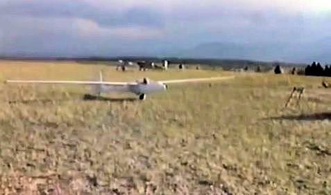
A 1972 photo by Jim Foreman (courtesy of Mark Hess) of a single-seat Burkhart Grob Flugzebau AG G102 Astir CS glider (serial #1171) at Black Forest,
with 4 other gliders in the background.
An amazing 1973 aerial view by Jim Foreman (courtesy of Mark Hess) depicted an amazing assemblage of at least 28 gliders & single-engine aircraft at Black Forest.

An undated photo of a glider in a tight turn over Black Forest from the movie “Memories of Black Forest Gliderport” by Jim Foreman.

An undated aerial view looking east at Black Forest Glider Port from the 1976 CO Airport Directory (courtesy of Alex Hauzer).
An advertisement for Black Forest Glider Port from the 1976 CO Airport Directory (courtesy of Alex Hauzer).

An undated photo of patch for the CO Soaring Association Black Forest Glider Port from the movie “Memories of Black Forest Gliderport” by Jim Foreman.

The last aeronautical chart depiction which has been located of the Black Forest Gliderport
was on the February 1977 Denver Sectional Chart (courtesy of Jim Hackman).
It depicted Black Forest Glider Port as a private field with 2 parallel paved runways, the longest being 5,000'.

A 1979 aerial view by Jim Foreman (courtesy of Mark Hess) of 2 gliders next to the Black Forest hangar.

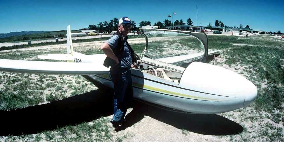
An undated photo of Jim Foreman & a Schweitzer SGS 2-32 glider tied down at Black Forest Gliderport.
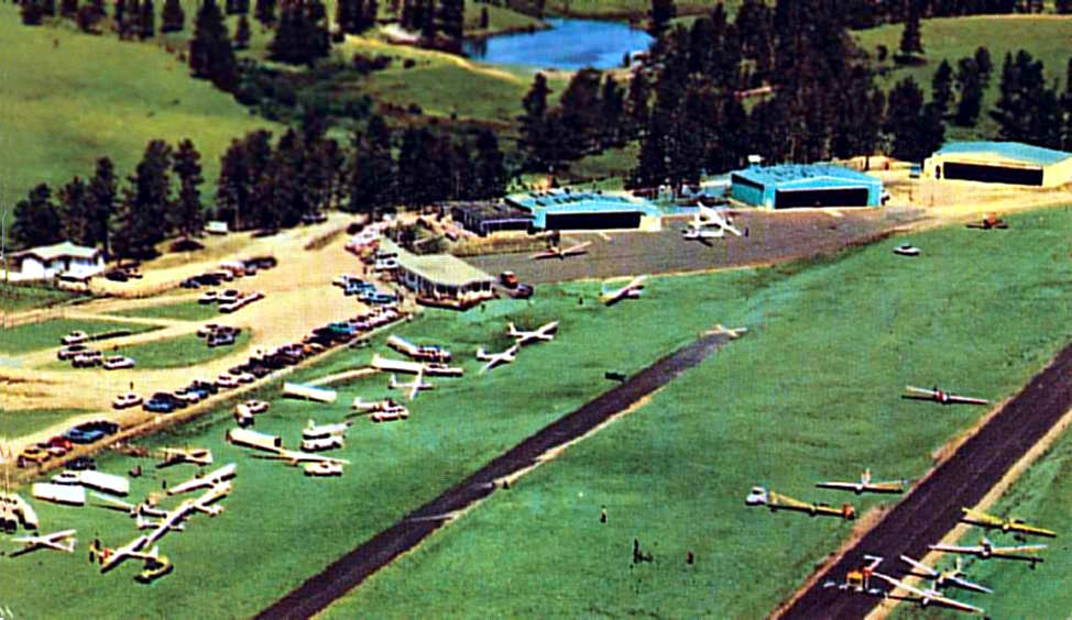
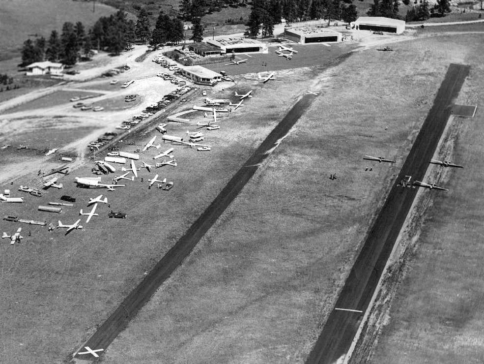
A circa 1970s aerial view looking north at a very busy Black Forest Gliderport(courtesy of Mike Newgard).
It depicted Black Forest as having 2 parallel asphalt runways, 3 hangars, and dozens of gliders.

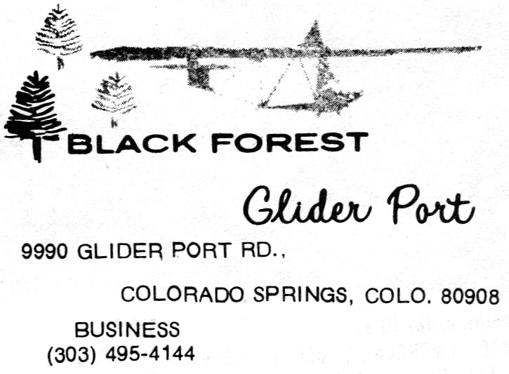
The logo of the Black Forest Gliderport.
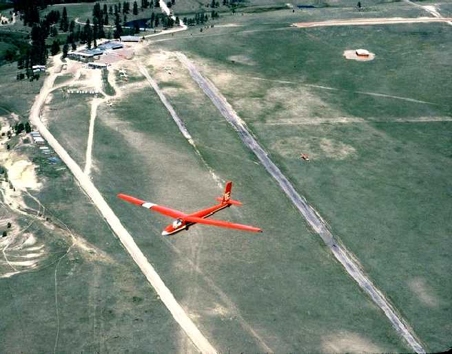
An undated aerial view by Jim Foreman looking north at a glider overflying Black Forest Gliderport,
with the paved runway, hangars, and a few gliders visible on the field.
Jim Foreman recalled, “It was a very unusual place with pilots coming from all over the world.
Also had a number of notable people come fly there, Neil Armstrong and most of the other astronauts came there at one time or another.
John Denver would often drop by for a day or two, especially if he wanted to get away from Aspen.
Hugh Downs kept a glider there for several years & would come there to fly.
In fact, the tail letters on his glider were OE for his program Over Easy.
You can see it in some of the photos like the red glider over the field (he sold it to the club for a dollar & the club had it repainted).
Christopher Reeve came a couple times as did John Wayne.
Beryl Markham (first woman to fly the Atlantic from east to west) when she was about 75.
She had never flown in a glider & wanted to get a ride.
I took her up & while she hadn't flown in many years, I could tell she still had the feel of an aircraft.
The world glider altitude record for women (41,428') was set there by Sabrina Jackintell who had a home at the northeast corner of the field.
That record still stands after 35 years.”
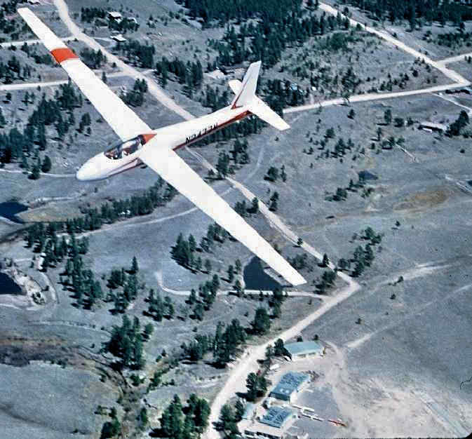
An undated aerial view by Jim Foreman looking north at a Schweitzer SGS 2-32 glider overflying Black Forest Gliderport,
with the hangars & a few gliders visible on the field.
An undated photo of N7531, a 1970 Schweizer SGS 2-32, serial #71 at the Black Forest Gliderport.
Kevin Shaw recalled, “Black Forest Glider Port... I gave instruction & rides there for a time in the early to mid-1980s.
In that era, the original owners sold the land to a real estate developer.
A real estate downturn delayed the redevelopment & allowed the airport operation to continue there for a time while an alternative location was found.”
Mike Newgard recalled, “It was very active until the mid-1980s. Lots of high altitude flights & some contests.”
The last pilot to land at Black Forest Gliderport, Darryl Hickey,
from Mike Cavanagh's 1986 video, The Last Day At Black Forest Gliderport.
According to Jim Foreman, “The day finally came when the insurance & airport permits ran out
and word was sent out that even though the place was technically closed, there would be one final party held at Black Forest Gliderport.
A tow plane was brought in & 5 or 6 people brought their gliders for one last flight.
Mike Cavanagh had a video camera & walked around visiting with people, unfortunately the sound was very bad and people could not be understood in places.
The last pilot to land at Black Forest Gliderport was Darryl Hickey.
Mike sent me the video which I posted on YouTube, The Last Day At Black Forest Gliderport.
It was more of a wake & I selected a funeral dirge from the Civil War as the musical backdrop to the video.
It was a great loss to soaring when it closed.”
Mike Cavanagh recalled, “After the LAST DAY & video I shot, the glider port ended up staying open for several weeks if not more.”
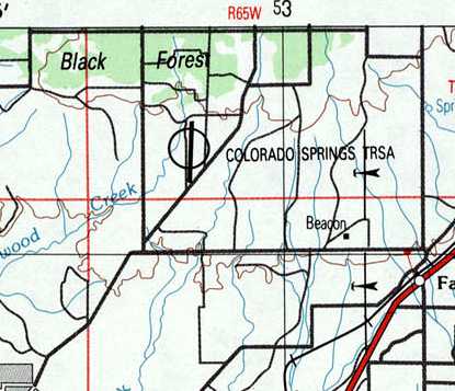
The last depiction which has been located of Black Forest Gliderport was on the 1989 USGS topo map.
It depicted the single runway of Black Forest,
but erroneously labeled the field as “Colorado Springs TRSA”, a dubious error by the mapmakers.
Jim Foreman reported, “The short version of what happened to Black Forest Gliderport.
First they tax hogs changed the zoning from ranch to light commercial
which multiplied the taxes by about 20 times which far exceeded any profit potential of keeping it open.
Mark Wild owned the 240 acres of the gliderport as well as 51% of Wave Flights, the commercial operation.
He was approached by a guy from Chicago who said he wanted to buy it as a long-time investment
so the property was valued for $3 million & the business for $300,000.
He paid the $300,000 up front & gave Mark a note for the $3 mil with a 10% interest to be paid annually.”
Jim continued, “Seeing the writing on the wall, the Colorado Soaring Association, which represented perhaps half of the income of the operation,
began to look for another home & bought the Owl Canyon Airport north of Fort Collins & moved there.
Their 5 gliders had been on leaseback to Wave Flights so that reduced the remaining equipment considerably.”
Jim continued, “At the end of the first year after the sale,
the Chicago owner couldn't come up with the $300,000 interest payment so it was added to the principal of the note.
Shortly after that, he began to sell the remaining equipment with Dick Seaman buying most of it.
He lived on what was called Glider Loop which was 80 acres carved out of the original land
which was divided into 5 acre plots and sold to settle the divorce when Mark & Ruth separated.
The ranch was originally 320 acres (half a section).”
Jim continued, “Then the Chicago owner sold the land to a guy named Aires from Phoenix
who was buying all the vacant land north & east of Colorado Springs that he could lay hand on.
Rumor had it that he paid $7.5 million which he borrowed from Lincoln Savings & Loan.
Mark still had the $3 million plus 10% interest 1stmortgage on the land but still hadn't received a dime from anyone, just rolling the interest back into the loan.
In order to get the taxes reduced, Aires simply gave all the hangars & other buildings to whoever wanted them as long as they were removed.
The Lennie Inn & Recreation Room somehow didn't go with the rest of the buildings & remained there for several years.”
Jim continued, “A year or so later the whole house of cards fell in with Lincoln S&L going toes up
and all the debt on all that money was dumped onto HUD & the government.
A new club called The Black Forest Soaring Society was formed from some local members of the Colorado Soaring Association
and made a deal to manage a new air park located about 20 miles to the north.
Mark Wild never got a dime out of the land but did finally regain ownership after about 7 years.
He had subdivided & sold most of it for homes but still had 40 acres right around where the hangars had been located when he died.”
The Black Forest Gliderport was evidently closed by 1997,
as it was no longer depicted at all on the January 1997 Denver Sectional Chart(courtesy of Richard Doehring).
Kurt Olson reported, “I met a guy [who] had a Black Forest Gliderport jacket on.
He said the reason they closed it was when they built the new east runway at KCOS, Black Forest Gliderport was in conflict with it.
It was a fun place with lots of activity.”
Kevin Shaw recalled, “The Black Forest commercial operation ended & a new successor club, the Black Forest Soaring Society was formed.
They purchased the hangers & clubhouse, and moved them to the new location –Kelley Air Park, a residential airport north of the old location.”
A 9/4/99 USGS aerial view looking south showed that all of the hangars & other airfield buildings had been completely removed,
with the ramp & hangar foundations remaining on the north side of the airfield site.
The entire length of the runway remained intact, though.
A 2005 aerial photo showed that streets & houses had covered the southern half of the airfield site at some point between 1999-2005.

A 10/23/11 aerial view looking south showed that the northern half of the Black Forest runway remained intact.
The site of Black Forest Gliderport is located north of the intersection of Forestgate Drive & Lochwinnoch Lane.
____________________________________________________
(Original) Pueblo Municipal Airport, Pueblo, CO
38.25, -104.66 (South of Denver, CO)

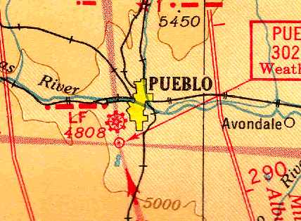
The location & layout of the Pueblo Airport, as depicted on the 7/26/27 Commerce Department Airway Bulletin (courtesy of David Brooks).
The original airport for the town of Pueblo was located on the southwest side of the town.
The date of construction of the airfield has not been determined.
According to a plaque by the Colorado Historical Society,
the hangar was constructed at the Pueblo Airport in 1925.
The earliest directory reference to the Pueblo Airport which has been located
was in the 7/26/27 Commerce Department Airway Bulletin (courtesy of David Brooks).
It described Pueblo Airport as a municipal field owned by the County, and operated by the Pueblo Commerce Club, caretaker Carle Jackson.
The field was said to consist of a 190 acre T-shaped sandy loam field, measuring 3,300' north/south.
A steel 120'x x 66' hangar was depicted on the east side.

The earliest photo which has been located of Pueblo Airport was a circa 1929-34 photo of 6 Air Corps Curtiss B-2 Condor heavy bombers.
According to Bill Grasha, “Only 13 were made so about half the production was visiting Pueblo.”
Pueblo's hangar & beacon tower are visible in the background.
The Airport Directory Company's 1933 Airport Directory (courtesy of Chris Kennedy)
described Pueblo as a municipal airport, located 3.25 miles southwest of the post office.
The field was said to consist of a 534-acre prairie grass field, “T” shaped,
containing a single 3,300' north/south runway.
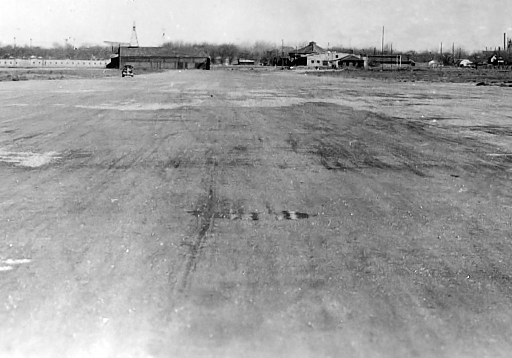
The earliest dated photo which has been located of the Pueblo Municipal Airport was a 2/7/38 view looking along an unpaved runway,
showing a hangar with a beacon tower, and several other small buildings.
The earliest aeronautical chart depiction of the Pueblo Airport which has been located
was on the December 1941 7M Regional Aeronautical Chart (courtesy of Chris Kennedy).

A 12/11/42 aerial view depicted Pueblo as having 5 runways, with a few small buildings & at least 4 light aircraft on the east side.
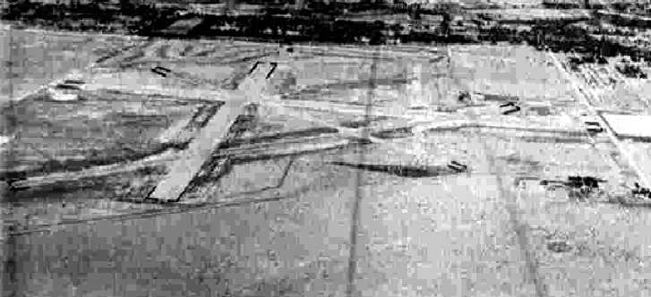
An 8/2/43 aerial view looking north from the 1945 AAF Airfield Directory(courtesy of Scott Murdock)
depicted Pueblo as having 4 paved runways.
The January 1944 Denver Sectional Chart (courtesy of Chris Kennedy)
continued to depict Pueblo as a municipal/commercial airport,
but it also depicted the newly-constructed Pueblo Army Air Field on the northeast side of the town,
which would eventually replace the original Pueblo Airport.
The 1945 Haire Publishing Airport Directory (courtesy of Chris Kennedy)
described Pueblo Municipal Airport as a “class 4” field, owned & operated by the City.
It was said to have 4 paved runways, with the longest being the 5,200' north/south strip.
A hangar was said to be marked with the field's name.
The field was said to offer airline service by Braniff & Continental.
The Southern Colorado Flying Service was listed as an operator,
and the Airport Manager was listed as E.G. Wayman.
The 1945 AAF Airfield Directory (courtesy of Scott Murdock) described Pueblo Municipal Airport
as a 546 acre irregularly-shaped property having 4 asphalt runways, the longest being the 5,200' north/south & northeast/southwest strips.
The field was said to have a single 128' x 70' steel & stone hangar,
and to have airline service by Braniff & Continental.
The airport was described as being owned & operated by the City of Pueblo.

The 1950 USAF Pilot's Handbook (courtesy of Chris Kennedy) depicted the original Pueblo Municipal Airport as having 4 paved runways,
with the longest being the 5,280' north/south strip.
A control tower & a building were depicted on the east side of the field.

The last photo which has been located of the Pueblo Municipal Airport was a 10/28/53 aerial view.
It depicted Pueblo as having 4 paved runways,
with some small buildings along the east side.

The last depiction which has been located of the original Pueblo Municipal Airport
was on the May 1954 Denver Sectional Chart (courtesy of Chris Kennedy).
It labeled the field as “Pueblo #1”, described it as a shared Air Force & public field,
and depicted the field as having a 5,300' hard-surface runway & a control tower.
The original Pueblo Municipal Airport was evidently abandoned at some point during 1954,
as it was no longer depicted at all on the November 1954 Denver Sectional Chart (according to Chris Kennedy).
In 1959, the Colorado Historical Society converted the old Pueblo Municipal Airport hangar into the original El Pueblo Museum.
A 1999 USGS aerial photo showed no recognizable trace of the original Pueblo Municipal Airport.

A 2007 photo by James O'Leary of the former Pueblo Airport hangar, since restored by the Colorado Historical Society.

A 2007 photo by James O'Leary of a plaque on the former Pueblo Airport hangar (with the word “hangar” misspelled).

A circa 2007-2010 aerial view looking north at the former Pueblo Airport hangar.
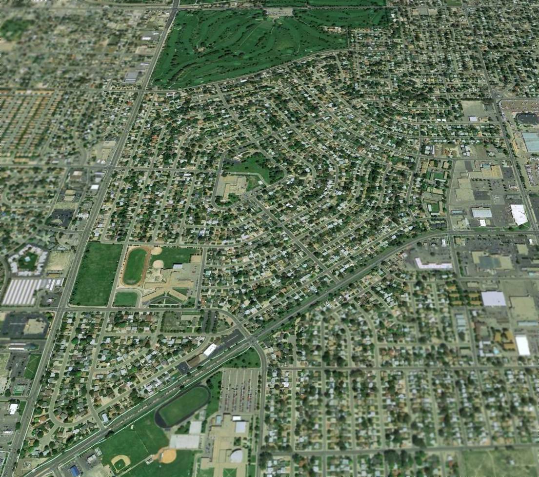
A 2013 aerial view looking north showed no recognizable trace of the original Pueblo Municipal Airport.
The site of the original Pueblo Municipal Airport is located northwest of the intersection of South Prairie Avenue & Route 78.
____________________________________________________
Aardvark Field, Colorado Springs, CO
39.035, -104.845 (South of Denver, CO)
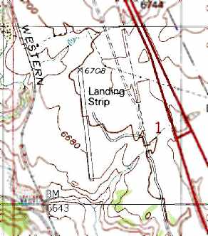
Aardvark Field was labeled simply as a “Landing Strip” on the 1986 USGS topo map.
Photo of the airfield while in use has not been located.
This small airfield is located on the north edge of the property of the Air Force Academy.
The date of construction of Aardavrk Field has not been determined.
It was not depicted at all on the 1983 USGS topo map.
The earliest depiction of the airfield which has been located is the 1986 USGS topo map,
which depicted the runway, labeled simply "Landing strip".
It was not depicted at all (not even as an abandoned airfield)
on the 1993 Denver Sectional Chart (according to Russ Roslewski).
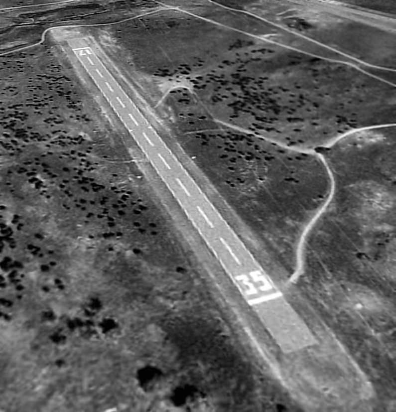
A 9/4/99 USGS aerial view looking northeast at Aardvark Field
depicted the field as consisting of a single 2,300 asphalt Runway 17/35, with no other facilities.
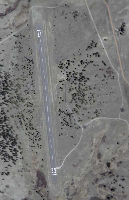
The 2002 USGS aerial photo depicted the field as consisting of a single 2,300 asphalt Runway 17/35, with no other facilities.
However, even though the airfield was not listed in the Airport Facility Directory as an active facility,
the runway was not marked as closed.
It was not depicted at all (not even as an abandoned airfield)
on the 2003 Denver Sectional Chart (according to Russ Roslewski).
According to a recent Academy graduate (via Russ Roslewski),
"The airstrip is used by the Academy's soaring training program.
The first flight or two before the cadets get into the gliders is done in a motorglider.
They use the runway for practicing patterns & approaches, though they do not touch down on it.
I suspect that may be due to lack of any support equipment or quick access in the event of a botched landing.
That explains why it's in good condition!
Operating here gets them away from the main airfield,
which at least up until several years ago I had seen listed as the busiest VFR tower in the world."
Therefore, this runway is not officially listed as an "airfield", since the aircraft apparently never actually land at it!
Truly a unique facility.

Aardvark Field, as depicted on an Air Force Academy local flying area publication (courtesy of Matthew Zimmerman).
According to Air Force Academy Cadet Matthew Zimmerman, "The airfield is known as 'Aardvark'.
It's listed on all our local area charts here.
It also can be (and has been) used as an emergency landing site for gliders if they can't get back to KAFF (extremely rare though)."
A 6/19/06 aerial view showed Aardvark Field still had runway numbers painted on its runway.

A 10/23/11 aerial view looking northwest showed that closed-runway X symbols were painted on each end of Aardvark's runway at some point between 2006-2011.

An April 2013 photo by Devan Mayer of Aardvark Field's windsock.

A 5/25/13 photo by Devan Mayer of a closed-runway X symbol painted on the end of Aardvark's runway.
Aardvark Field is located northwest of the intersection of Interstate 25 & North Gate Boulevard,
only 4 miles north of the Air Force Academy's main airfield.
Thanks to Russ Roslewski for pointing out this airfield.
____________________________________________________
Since this site was first put on the web in 1999, its popularity has grown tremendously.
That has caused it to often exceed bandwidth limitations
set by the company which I pay to host it on the web.
If the total quantity of material on this site is to continue to grow,
it will require ever-increasing funding to pay its expenses.
Therefore, I request financial contributions from site visitors,
to help defray the increasing costs of the site
and ensure that it continues to be available & to grow.
What would you pay for a good aviation magazine, or a good aviation book?
Please consider a donation of an equivalent amount, at the least.
This site is not supported by commercial advertising –
it is purely supported by donations.
If you enjoy the site, and would like to make a financial contribution,
you
may use a credit card via
![]() ,
using one of 2 methods:
,
using one of 2 methods:
To make a one-time donation of an amount of your choice:
Or you can sign up for a $10 monthly subscription to help support the site on an ongoing basis:
Or if you prefer to contact me directly concerning a contribution (for a mailing address to send a check),
please contact me at: paulandterryfreeman@gmail.com
If you enjoy this web site, please support it with a financial contribution.
please contact me at: paulandterryfreeman@gmail.com
If you enjoy this web site, please support it with a financial contribution.
____________________________________________________
This site covers airfields in all 50 states.