
Abandoned & Little-Known Airfields:
Eastern Colorado
© 2002, © 2016 by Paul Freeman. Revised 1031/16.
This site covers airfields in all 50 states: Click here for the site's main menu.
The CO pages of this website are sponsored by the Colorado Pilots Association:
____________________________________________________
Please consider a financial contribution to support the continued growth & operation of this site.
Alexander Dawson School Airfield (revised 5/2/13) -Arlington Aux AAF #4 (revised 11/16/14)
Burlington Municipal (revised 3/15/13) – (Original) Fort Collins Municipal / Christman Field (revised 1/10/16)
Las Animas Aux AAF #2 (revised 3/15/13) - Rocky Ford Aux AAF #1 (revised 3/15/13)
Valley Airport / Fort Collins Airpark / Fort Collins Downtown Airport (revised 10/31/16)
____________________________________________________
Alexander Dawson School Airfield, Boulder, CO
40.059, -105.107 (Northwest of Denver, CO)
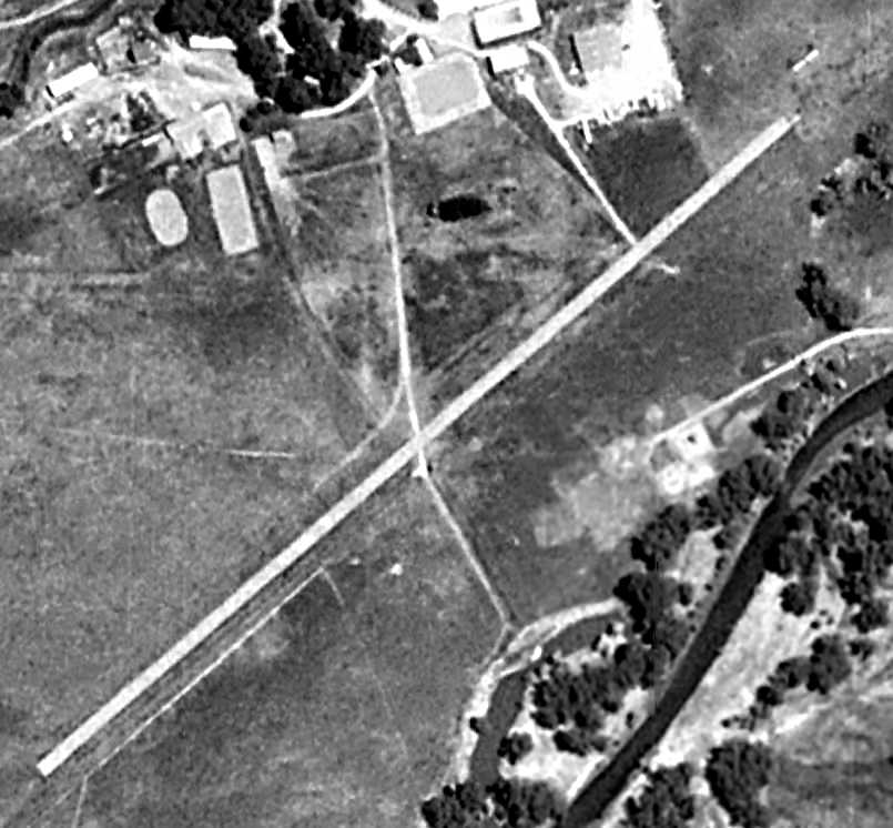
Alexander Dawson School Airfield, as depicted on the 1993 USGS aerial photo.
The date of construction of this runway on the grounds of a private school has not been determined.
According to the Dawson School website, “In the latter part of the decade [the 1970s], the first head of school, John Harmon,
hired his brother-in-law, a former PanAm pilot, to begin flying lessons & allowed students to earn a pilot’s license.
Only Privileged Citizens could take flying lessons.
You can still see the school’s original landing strip from the air.
There was also a power line on US-287, which the students had to take into account when landing.”
No airfield was depicted at this location on the 1979 USGS topo map.
The date of closure of the airfield has not been determined.
The earliest depiction which has been located of the Dawson airfield was the 1993 USGS aerial photo,
which depicted a single northeast/southwest paved runway to the south of the school buildings.
There were no aircraft visible on the field.
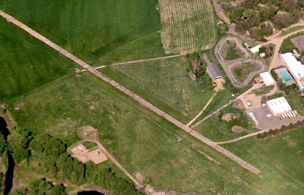
A circa 2005-2010 aerial view looking south at the Dawson School runway.
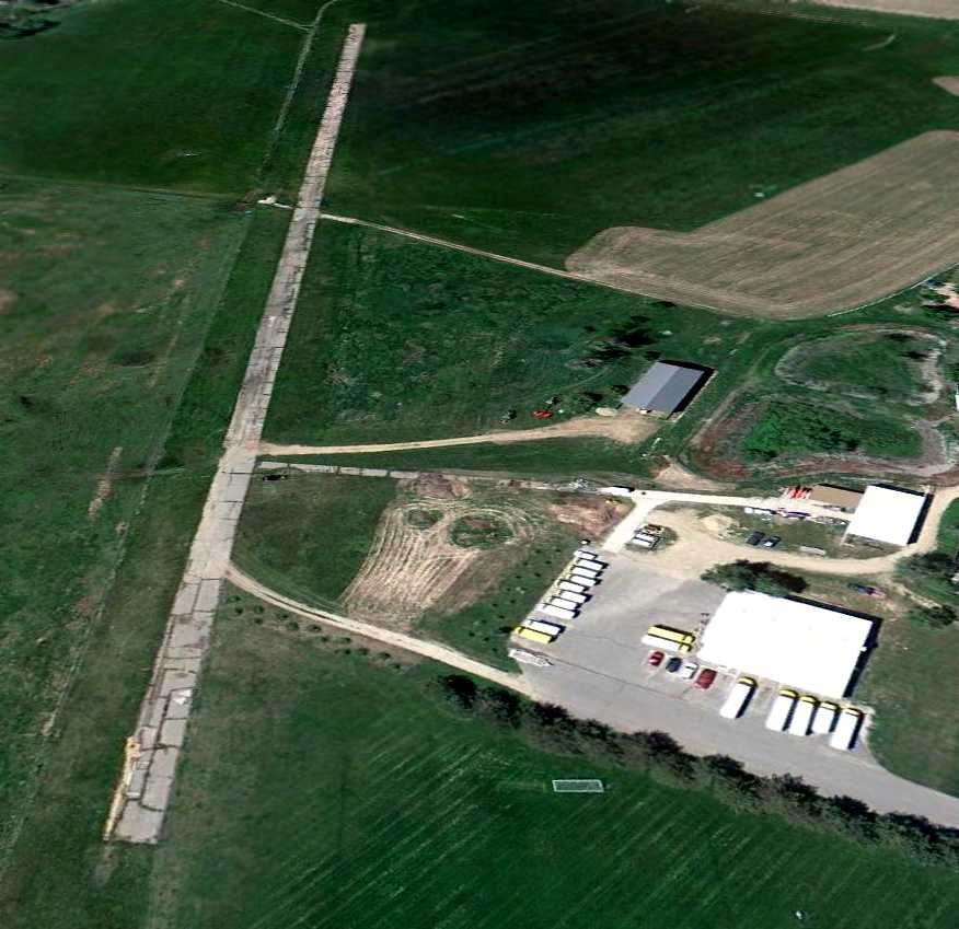
A 6/16/10 aerial view looking southwest at the Dawson School runway.
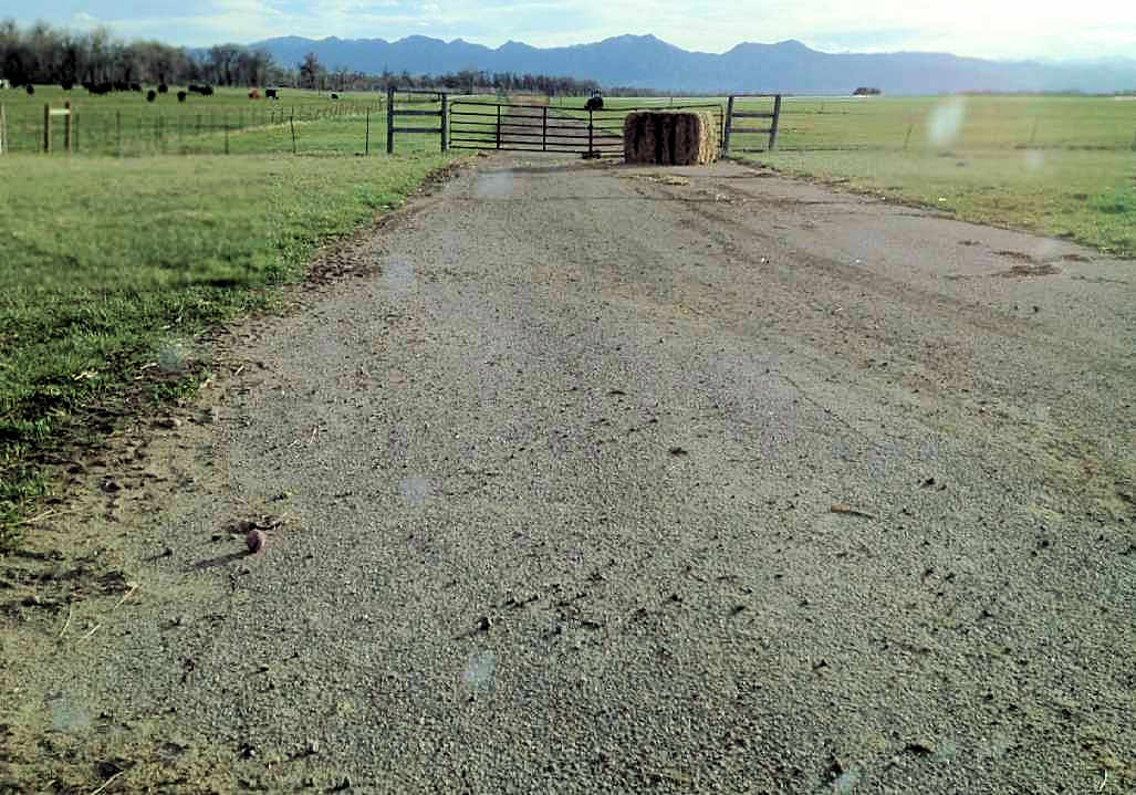
A 4/29/13 photo by Paul Freeman looking southwest along the remains of the Dawson School runway.
Even from close-up, you would not necessarily know it was a former runway.
The site of the Dawson School Airfield is located southwest of the intersection of Dawson Drive & Route 287.
____________________________________________________
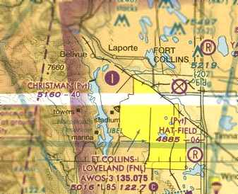
Fort Collins Municipal Airport (original location) / Christman Field (CO55), Fort Collins, CO
40.595, -105.143 (North of Denver, CO)

The original Ft. Collins Airport, as depicted on the January 1936 Cheyenne Sectional Chart.
The original airport for the town of Ft. Collins was located on the northwest side of the town.
According to the Fort Collins Library, “In May, 1929, the people of Fort Collins dedicated an airfield at the west end of La Porte Avenue.
A plane carrying mail left for Denver to advertise the availability of the field.”
The earliest official listing which has been located of the airport
was in the 9/1/1931 Department of Commerce Airport Directory (courtesy of Chris Kennedy).
It described Fort Collins Airport as a commercial field, located 3.5 miles west of the city.
It was said to consist of a rectangular 200 acre sod field,
within which were 5 runways, with the longest being a 3,000' northeast/southwest strip.
The field was said to offer a hangar, minor service, and fuel.
The earliest aeronautical chart depiction which has been located of the Ft. Collins Airport
was on the January 1936 Cheyenne Sectional Chart.
The Airport Directory Company's 1937 Airports Directory (courtesy of Bob Rambo)
described the Fort Collins Municipal Airport as being located 3.5 miles west of the city.
It was said to consist of a rectangular 200 acre sod field,
within which were a total of 5 runways, with the longest being a 3,000' northwest/southeast strip.
The field was also said to have a hangar.
The airport was evidently renamed “Colorado State College” at some point between 1939-41,
as that is how it was labeled on the December 1941 Cheyenne Sectional Chart (courtesy of Chris Kennedy).
It was still labeled “Colorado State College” on the July 1942 Cheyenne Sectional Chart (according to Chris Kennedy).
The earliest photo which has been located of “Fort Collins Airport (Colorado State College Airport)”
was a 8/29/43 aerial view looking north from the 1945 AAF Airfield Directory (courtesy of Scott Murdock).
It depicted the field as having 2 unpaved runways, with a few small buildings on the south side.
The airport was labeled “Fort Collins” on the January 1944 Cheyenne Sectional Chart (courtesy of Chris Kennedy).
The 1945 AAF Airfield Directory (courtesy of Scott Murdock) described “Fort Collins Airport (Colorado State College Airport)”
as a 300 acre irregularly-shaped property having 2 gravel runways, measuring 3,900' north/south & 3,700' northwest/southeast.
The field was said to have 3 brick hangars, the largest being a pair measuring 80' x 60',
to be owned by Colorado State College, and operated by private interests.

A 9/21/53 USGS aerial photo depicted Fort Collins Airport
as having 2 unpaved runways, with 3 hangars & 2 light planes on the southeast side.
It was still labeled “Fort Collins” on the November 1954 Cheyenne Sectional Chart (according to Chris Kennedy).
In April 1955, Univair sold the FAA aircraft type certificate for the former Erco Ercoupe
to the Forney Aircraft Company of Fort Collins, which later became the Fornaire Aircraft Company.
The Forney / Fornaire Aircoupe was similar to the Ercoupe 415-G except for engine & propeller combination,
revised engine cowling, outer wing panels, metal covered, baggage compartment extended,
and modifications of seats & instrument panel.
John Kern recalled, “I began my earliest flying stint in the 1950s at Fort Collins in a J3 cub at the Forney Airport.
J.D. Forney owned a company, Forney Arc Welders, and also the airstrip... one runway north/south & his hangar & his welder manufacturing plant.
I worked for him as I went to college in about 1956.
He had a Luscombe Observer that was a WW2 observer aircraft that I spent hundreds of hours polishing... I hated that airplane.”
Forney production began in Fort Collins in 1958.
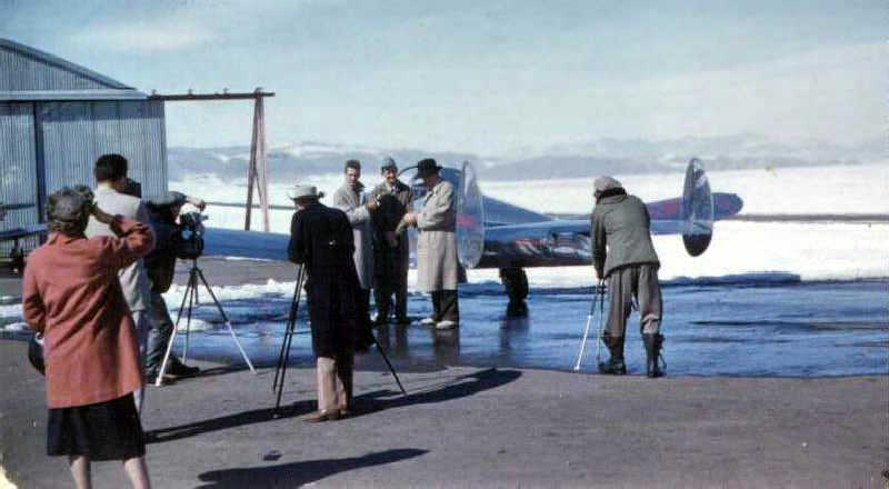
A circa 1958 photo (courtesy of William Werner) of ceremonies for the maiden flight at Christman Field of Forney's first aircraft.
William recalled that his father “worked with Forney many years ago in Fort Collins as his financial manager
and played a part in Forney getting started.
Forney was a small welder company in Fort Collins when my Dad started there.
Forney called my Dad from out of town & said he was buying parts to build 25 planes for about $50,000 surplus (in California) & was going into the plane business.
When the parts arrived there were missing parts & duplicate parts.
The companies that made the parts were out of business so they had to have new parts custom made to make up the difference.
It ended up costing more than they expected.
It was a loosing venture supported by the welder business.”
A total of 56 of the F-1 Forney Delux were produced in 1958, listing for $6,995 each.
A total of 59 of the F-1 Forney Explorer, Execta and Expediter were produced in 1959, listing for $6,995 each.
A total of 23 of the F-1A Forney Trainer were produced in 1959, listing for $7,450 each.
The airport was evidently renamed “Christman” at some point between 1954-59,
as that is how it was labeled on the June 1959 Cheyenne Sectional Chart (courtesy of Chris Kennedy).
It was depicted as having a 4,000' paved runway.
According to the Fort Collins Library, the airport was “named Christman Field in honor of a World War II pilot.”
In 1960 Forney sold the rights to the Aircoupe aircraft to the AirCoupe division of Air Products Company of the City of Carlsbad, NM.
William Werner recalled, “My Dad ended up brokering the deal to sell the company in the City of Carlsbad, NM for Forney.”
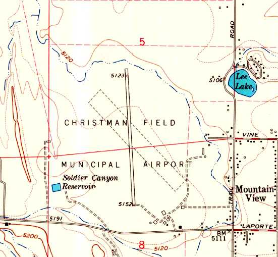
The 1962 USGS topo map depicted “Christman Field Municipal Airport” as having a north/south paved runway & an unpaved northwest/southeast runway.
Several buildings were depicted on the southeast side of the field.
Christman Field was still depicted as a public-use airport on the June 1965 Cheyenne Sectional Chart (according to Chris Kennedy).
When the new Fort Collins Airport opened in 1965-66,
Fort Collins passed ownership of Christman Field to Colorado State University.
At this point the airport may have been closed.
Strangely, Christman Field was not depicted at all on the December 1968 Cheyenne Sectional Chart (courtesy of Chris Kennedy).
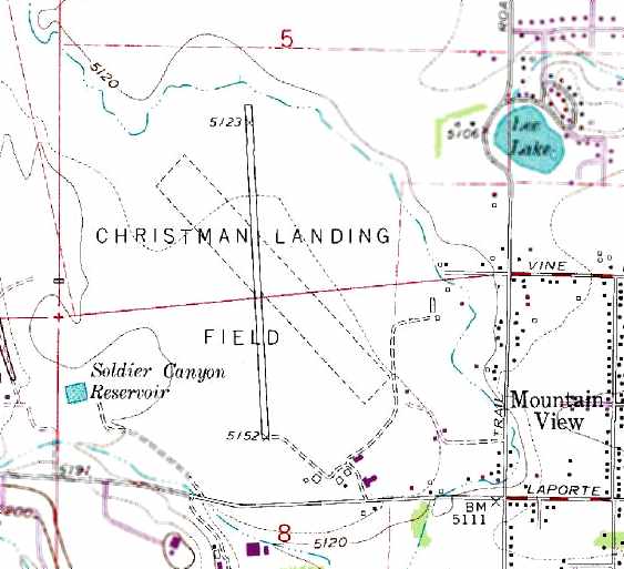
The 1971 USGS topo map depicted “Christman Landing Field” as having a north/south paved runway & an unpaved northwest/southeast runway.
Several buildings were depicted on the southeast side of the field.
Christman Field was evidently reopened as a private airfield at some point between 1968-76,
as that is how it was depicted on the March 1976 Cheyenne Sectional Chart (according to Chris Kennedy).
Mark Williams recalled, “I flew out of here in the late 1970s with the CSU Ram flying club.”
Mark also reported that Christman Field's rotating beacon was relocated to Fort Collins Downtown Airport in 1979.
Mark Williams recalled, “My last flight through here was in a Colorado Army National guard UH-1H in 1984.”
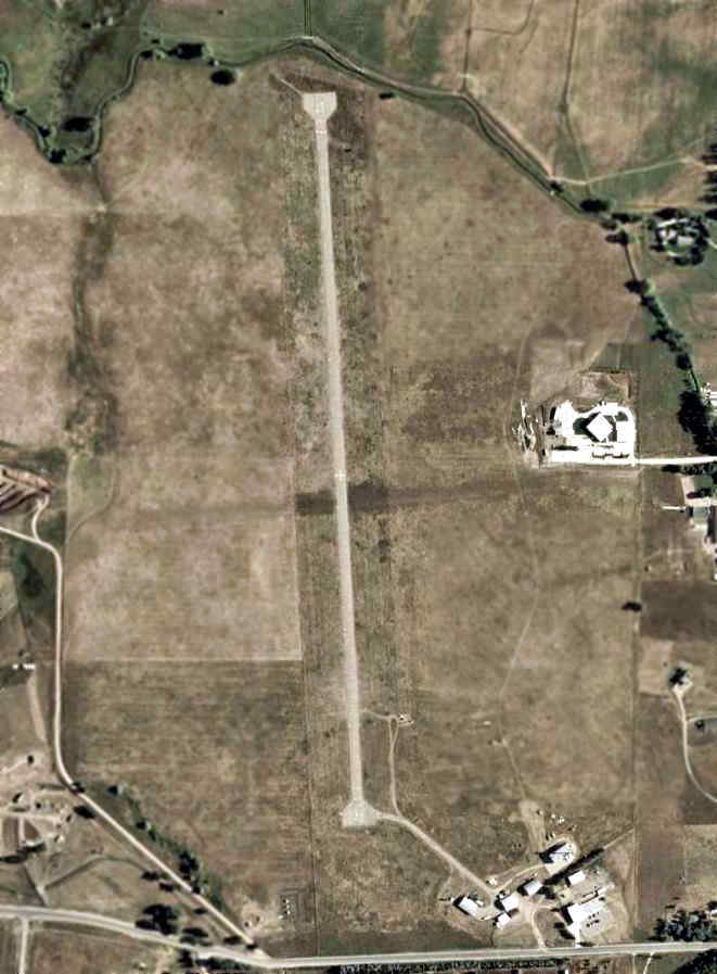
A circa 2006 aerial view of Christman Field showed the single north/south paved runway,
as well as the cluster of hangars to the southeast.
No planes were visible on the field.
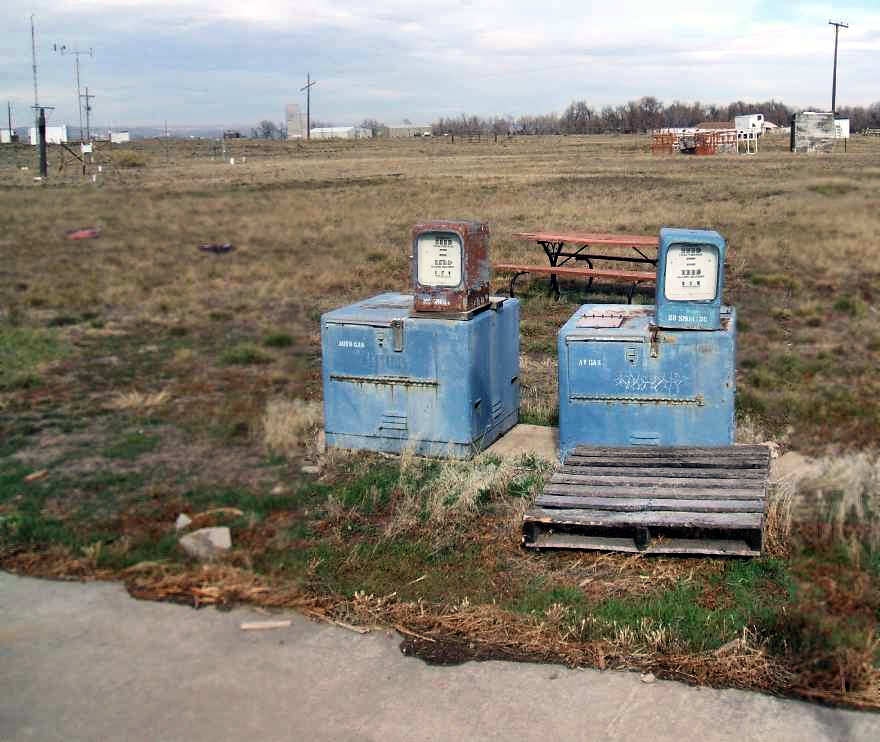
A 2006 photo by Mark Williams of 2 gas pumps at Christman Field.
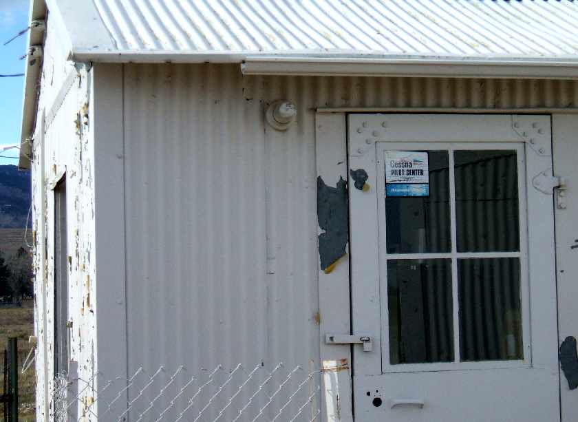
A 2006 photo by Mark Williams of a “Cessna Pilot Center” decal on the window of a building at Christman Field.
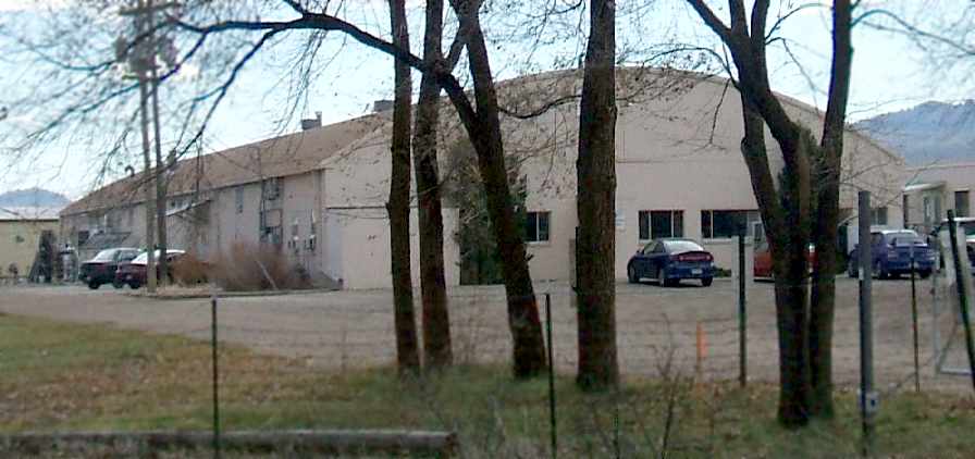
A 2006 photo by Mark Williams of the hangar at Christman Field in which Luscombes were assembled.
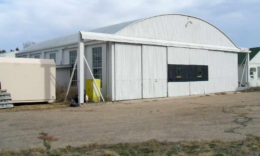
A 2006 photo by Mark Williams of a hangar at Christman Field.
In 2007, the FAA's Airport/Facility Directory data for Christman Field described it as being owned by Colorado State University,
with the airport manager listed as Walt Naylor.
The field was said to consist of a single 4,000' asphalt Runway 16/34, “Marked with '+' in middle” (which is visible on the aerial photo),
and it was said to have one single-engine aircraft based on the field.
Mark Williams reported in 2007, “The airport has been used sporadically over the years,
with aerial fire-fighting airplanes residing during the summer, and atmospheric science research aircraft.
This year, CSU has announced the permanent closure of the facility, which is sad, as it is one of the oldest airports in Colorado.
It is also the 2ndFort Collins airport to close since 2006, with the closure of 3V5, Downtown Fort Collins.”
The 2007 Denver Sectional Chart depicted Christman as a private field having a single 4,000' paved north/south runway.
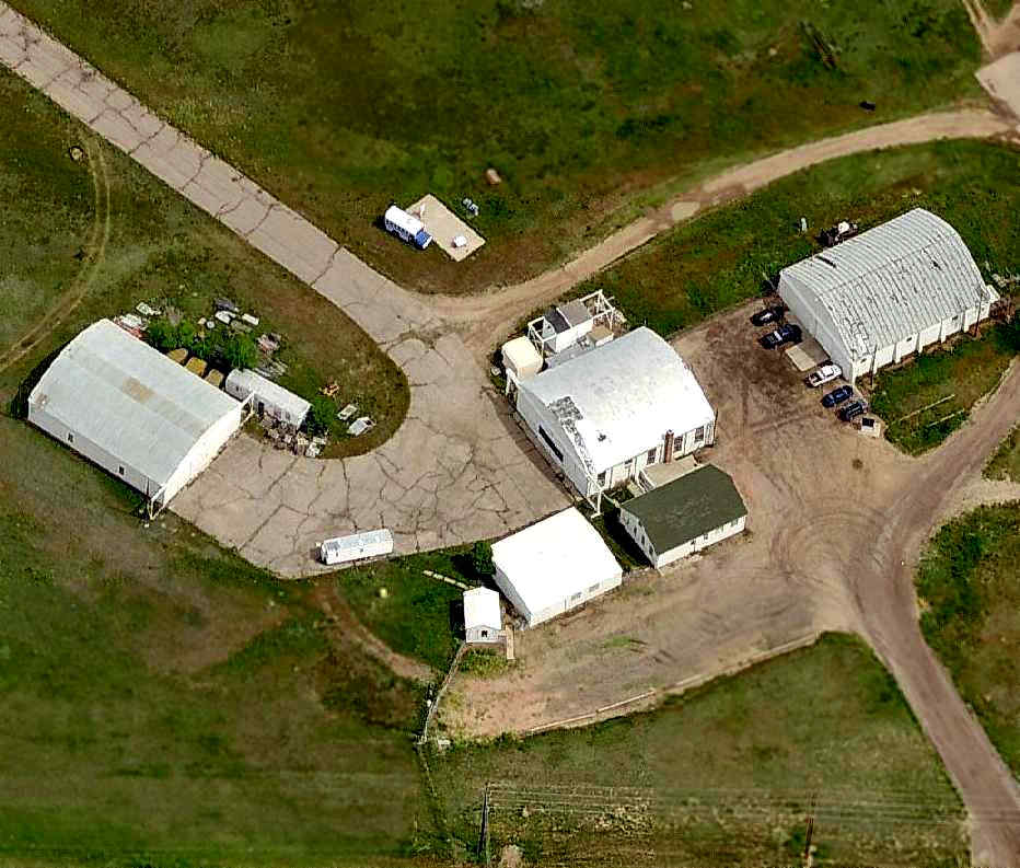
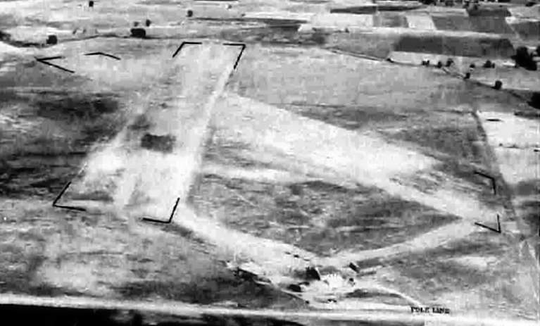
A circa 2007 aerial view looking north at 3 hangars which remain at the southeast corner of Christman Field.
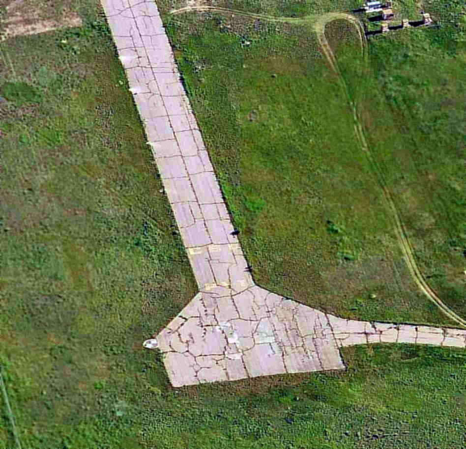
A circa 2007 aerial view looking north at the south end of Christman's former Runway 34.
Sean Parker reported in 2009, “I am a Mechanical Engineering student at Colorado State University in Fort Collins.
I spend much of my time in the Motorsport Engineering Research Complex (MERC) in the Foothills Campus here at CSU.
The facility is located in the former Fornyaire manufacturing facility, but is still a ways away from Christman Field itself
(it may be on the grounds but there is no paved road or path directly to the runway or the field facilities... at least not anymore).
The area around the airfield is pretty flat so there might have been a track or something at one time.
We are the large light colored complex due East of the center of the runway.
Prior to this being the MERC it was the AERC, the Atmospheric Engineering Research Complex,
and it is still listed on the map provided by CSU as such, even though the changeover happened almost a decade ago.
The facility is currently used for Senior and Graduate student's projects: the Formula SAE & Formula Hybrid race cars,
the SAE-Aero remote control airplane, composite engine valves, etc.
There is a full machine shop here that might use some of the old tooling from Forney.
As the runway is in such close proximity and in relatively decent shape, with the exception of some plant growth,
it is still used by some of the race teams to perform testing on their cars.
It's length obviously allows for some pretty high-speed testing!
I've also been aware of it being used intermittently as a base for firefighting aircraft during the summer,
but I've never physically seen an aircraft use the field.
At any rate the facilities on the south end of the runway are purely educational in nature now
and any fuel, spares, etc. would have to be brought in from elsewhere.”
Christman Field is located northwest of the intersection of Laporte Avenue & North Overland Trail.
____________________________________________________
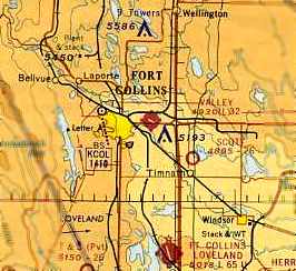
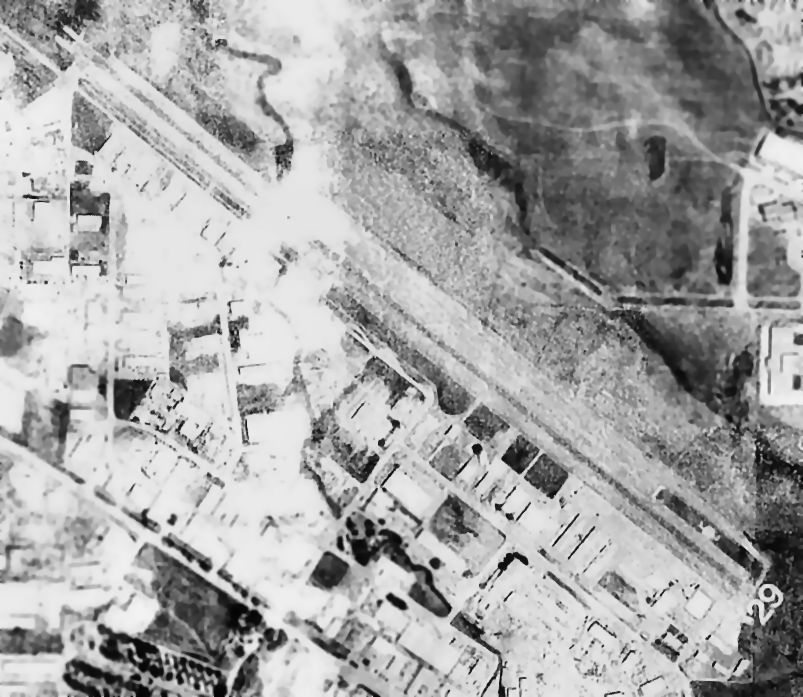
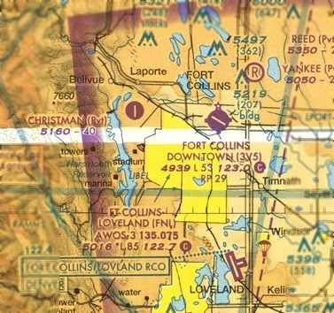
Valley Airport / Fort Collins Airpark / Fort Collins Downtown Airport (3V5), Fort Collins, CO
40.59, -105.045 (North of Denver, CO)
Valley Airport, as depicted on the December 1968 Cheyenne Sectional Chart (courtesy of Chris Kennedy).
No airfield was yet depicted at this location on the 1960 USGS topo map.
This airport on the northeast side of Fort Collins was established in 1966,
according to the inscription on a rock at the airport entrance.
The airport was first named Valley Airport,
as that is how it was depicted on the December 1968 Cheyenne Sectional Chart (courtesy of Chris Kennedy).
It depicted Valley as having a single 3,200' paved northwest/southeast runway.
Bill Bates recalled, “I was at CSU in the mid-1960s & got my ratings through the flying club.
The manager of the 'Airpark' as we referred to it then & my instructor was Elliott Ray.
He was a wonderful man who also flew for the Atmospheric Research Department.”
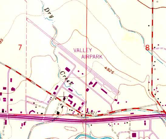
The earliest topo map depiction which has been located of Valley Airpark was on the 1969 USGS topo map.
It depicted Valley Airpark as having a single paved northwest/southeast runway, with a parallel taxiway & a ramp with several buildings on the south side.
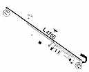
The 1972 Flight Guide (courtesy of Chris Kennedy)
shows that the runway at Valley had been lengthened to 4,700' at some point between 1968-72.
Several hangars were depicted on the south side of the runway.
By the time of the 1976 Airport Directory (according to Chris Kennedy),
the field had been renamed “Fort Collins Airpark”.
By the time of the September 1977Cheyenne Sectional Chart (according to Chris Kennedy),
the field had been renamed yet again, this time to “Downtown Fort Collins” Airport.
According to Mark Williams, it was “at one time was a bustling little airport.
I remember when the airport opened. I was 6 years old at the time.
By my teen years I was biking to Fort Collins Downtown Airport every spare moment.
I soloed at 16, in a Piper Warrior, (N75303) and received my license at 17.
I worked there as a line boy in 1978, driving the old Chevy fuel truck.
This airport was the home to Vintage Aircraft, Ltd., which was home to numerous P-51 mustangs.
I personally fueled 'Precious Metals' & 'Rare Bear' in the late 1970s.
I wish that I had owned a camera back then!
The beacon was moved from the old Christman Field, CO55, in 1979.”
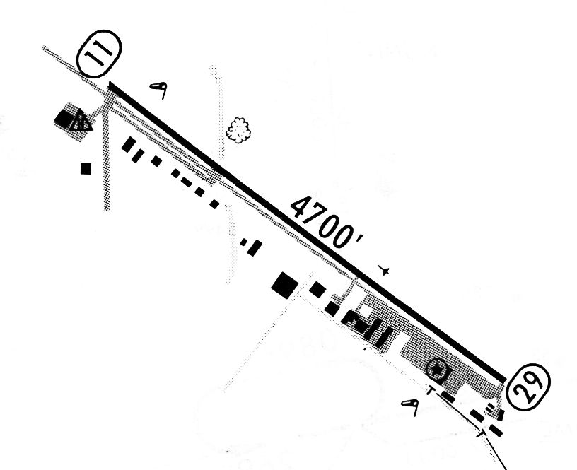
A 2/5/81 airport directory (courtesy of John Kielhofer)
depicted Downtown Ft Collins Airpark as having a 4,700' paved Runway 11/29.

The 1984 USGS topo map depicted the “Downtown Fort Collins Airpark” as having a single paved northwest/southeast runway,
and a ramp on the south side of the field with several hangars.
The earliest photo which has been located of Ft. Collins Downtown Airport
was an undated aerial view from the 1995 CO Airport Directory (courtesy of Jonathan Westerling).
It described the field as having a single 4,699' paved runway 11/29.
Martin Zakes recalled, “I worked there as a line boy in the late 1990s & saw its slow deterioration.
It was the best time of my life, though!”
According to Mark Williams, “In 2001 I returned to Fort Collins Downtown Airport as a part-time CFI.”
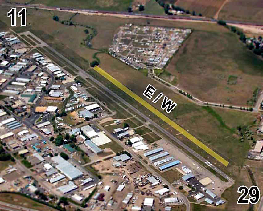
An undated aerial photo from the 2006 CO Airport Directory, looking north at the Fort Collins Downtown Airpark,
showing the paved Runway 11/29 as well as the turf East/West runway.
In its final year of operation (2006), the published FAA Airport/Facility Directory statistics for the Fort Collins Downtown Airport
described the field as having a single 5,326' asphalt Runway 11/29, “in fair condition”.
There was also listed a 3,400' turf East/West runway,
which had the remarks “Total landing area is 3,400' only easternmost/westernmost 1,700' used at any one time.
East/West runway very soft when wet.”
The field was said to be home to a total of 126 aircraft (including 20 multi-engine aircraft & 15 helicopters),
and it was said to conduct an average of 48 takeoffs or landings per day.
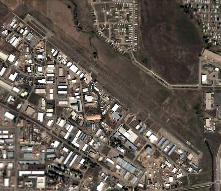
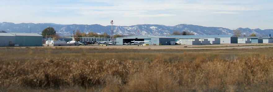
A 2006 aerial photo showed the Fort Collins Downtown Airport to have a modest number of planes
parked on ramps on the center & southeast parts of the field.
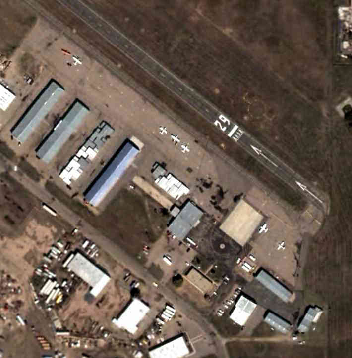
A closeup from the 2006 aerial photo showing several planes parked on the southeast ramp at the Fort Collins Downtown Airport.
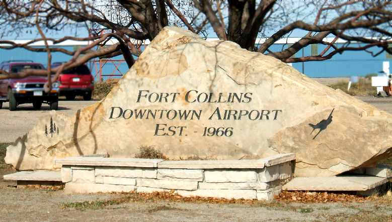
A 2006 photo by Mark Williams of a rock bearing an inscription
giving the date of 1966 for the establishment of Fort Collins Downtown Airport.
A 2006 photo by Mark Williams of the scene at Fort Collins Downtown Airport a few days before it closed,
showing a few light planes on the ramp.
Mark observed, “It looks busy, but the business is deceiving, as most of those airplanes are there for maintenance before being flown out!”
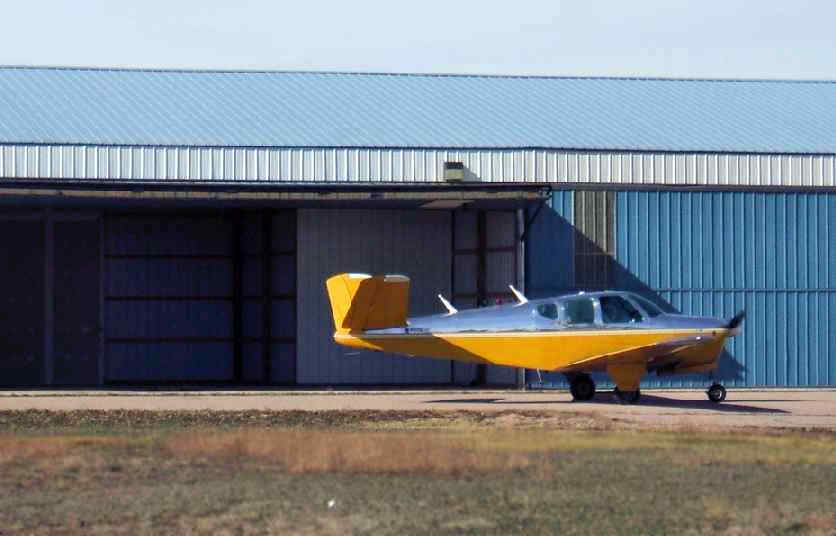
A 2006 photo by Mark Williams of a Bonanza taxiing in front of a hangar at Fort Collins Downtown Airport a few days before it closed.
The August 2006 Cheyenne Sectional Chart depicted the Fort Collins Downtown Airport
as having a single 5,300' paved runway.
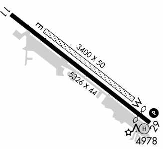
The September 2006 approach plate for Fort Collins Downtown Airport's VOR-DME/GPS-B approach (courtesy of Lew McCain)
depicted the field as having a 5,326' paved Runway 11/29 along with a parallel unpaved runway on the northeast side.
The Fort Collins Downtown Airport was closed in October 2006.
Mark Williams noted, “I find it difficult to comprehend that 3V5 is gone.
For me this was a field of dreams.
The field was a privately-owned public-use airport.
It probably was the victim of complacency.
I remember visiting the airport from time to time.
Having instructed in California, I would always ask 'How secure is 3V5's future?'
The answers I would get usually revolved around 'The airport is built on floodplain' & 'The owners don't want to sell.'
Sadly, this airport needed a strong pilots' group.”
A sad sight – a 2006 scene by Mark Williams of Fort Collins Downtown Airport 3 days after the airport closed, devoid of any planes.
This airport has a tremendous amount of aviation infrastructure – what a shame to see it going to waste.
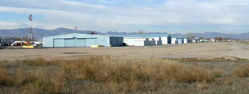
A circa 2007 aerial view looking south at the Geo-Seis Helicopters Heliport (0CO4), one of 2 remaining heliports at the site of Fort Collins Downtown Airport.
What appears to be an Aerospatiale Lama helicopter is on the helipad,
and a red Luscombe taildragger is also visible – what appears to be the last fixed-wing aircraft remaining at the closed airport.
Chris Goin reported, “The very large hangar on the left side is the former site of Vintage Aircraft.”
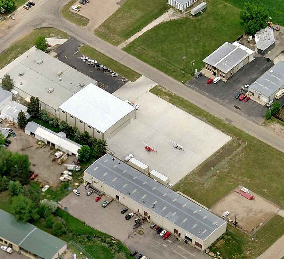
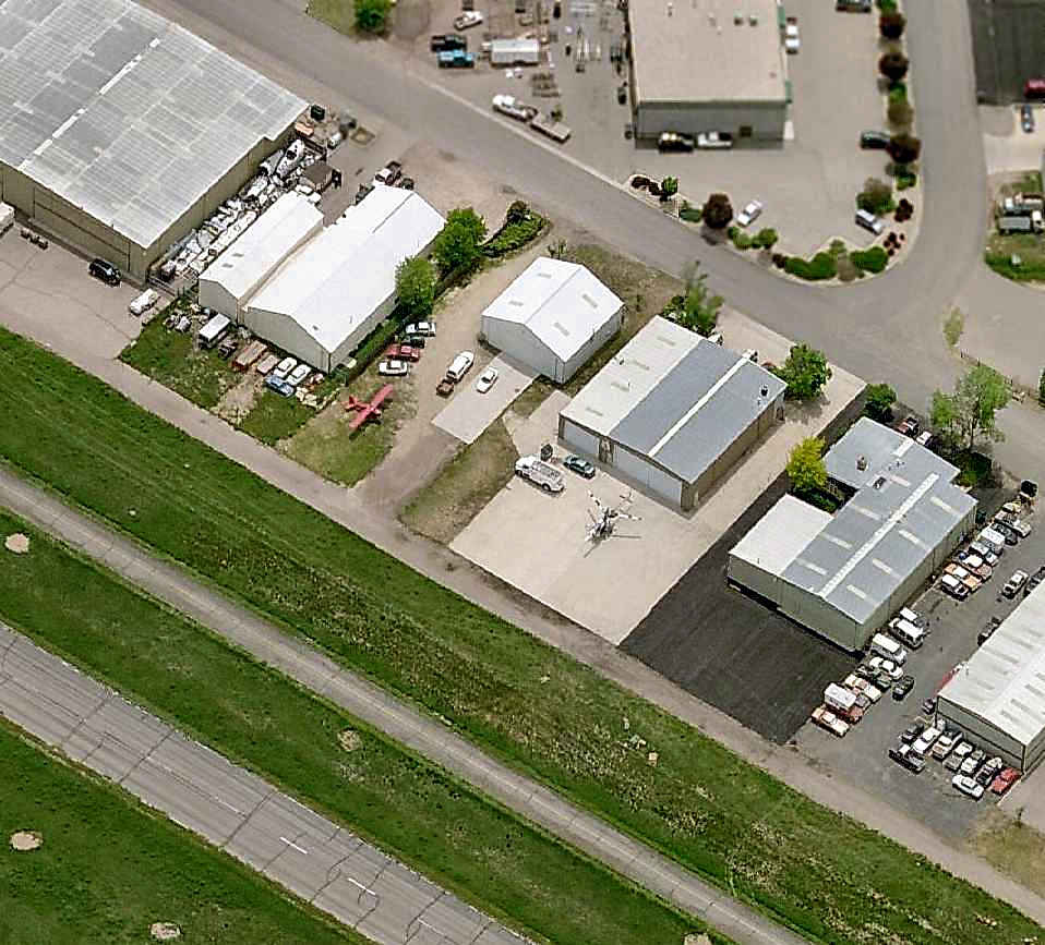
A circa 2007 aerial view looking north at the North Arrow Heliport (CD46),
operated by Paravion Technology, one of 2 remaining heliports at the site of Fort Collins Downtown Airport.
What appear to be 2 Bell JetRangers are visible on their ramp.

A 9/13/13 aerial view looking northeast showing flooding adjacent to Fort Collins Downtown Airport.
Allan Wendt reported, “Some of the hangars are flooded”, as a result of the large-scale floods that affected the area.
Chris Goin reported in 2015, “Geo-Seis is no longer along the runway, only North Arrow remains functional.
Helicopters fly over my house daily going in & out for maintenance and fuel.
The red Luscbome [pictured above near the Geo-Seis heliport]... Poor old girl has a bent right wing & rudder hanging off one hinge.
I was fortunate today, I stepped outside of my house & heard an engine roaring pretty loudly.
I figured we were about to see a big girl fly low overhead, however the sound continued from one direction.
I walked to where I could see the field & saw a Vultee BT-13 Valiant running up outside Vintage Aircraft's open hangar doors!
I jumped in my car & drove around to the runway & came up behind the old girl.
I was fortunate enough to talk with the gentlemen hanging out there & learned a few things.
The old Valiant had been sitting since the airport, and consequently Vintage, had closed.
The men there were former employees who pay for the hangar still & are preparing the old girl for her 'final' flight away from Downtown.
It sure was good to hear the old P&W roar as they were getting the rings to re-seat & checking everything out.”
Chris continued, “I say 'final' because of the other thing I learned. The rumor that the airport had been bought is true.
The gentleman who bought it would like to see it become active once more, however his condition is that the property taxes be paid for.
The challenge now, upon which the future of the airport hangs, is whether that can be achieved.
The hope is that the new Woodward Governor campus being built just blocks away at Mulberry & Lemay
will spur Woodward to help with the taxes for the benefit of having an airport just jogging distance away. Time will tell.
In addition to the Luscombe, an old Bellanca Viking sits languishing alongside the runway.
Her N-number expired on the 31st of December & I could not get her owner to return my calls,
so it seems the old wood-spar beauty may never ply the skies again.”
Fort Collins Downtown Airport is located northwest of the intersection of East Mulberry Road & South Timberline Road.
____________________________________________________
Burlington Municipal Airport (3V1), Burlington, CO
39.31, -102.28 (Southeast of Denver, CO)
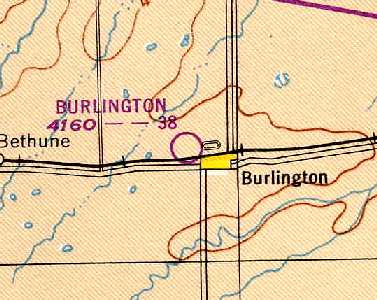
Burlington Airport, as depicted on the 1949 Denver Sectional Chart (courtesy of Chris Kennedy).
This general aviation airport was evidently opened at some point between 1935-36,
as the earliest reference to the Burlington Airport which has been located
was in the 1936 Civil Aeronautics Administration Airways Bulletin #2 (courtesy of David Brooks).
It described Burlington as having 3 turf runways, with a total field size of 3,170' x 2,608'.
Burlington Airport was also listed among active airfields
in The Airport Directory Company's 1938 & 1939 Airport Directories (according to David Brooks).
The earliest depiction which has been located of Burlington Airport
was on the 1942 7M Regional Aeronautical Chart (according to David Brooks).
Burlington Airport was depicted on the 1944 7M Regional Aeronautical Chart (according to David Brooks).
The Burlington Airport may have gone through a brief period of closure during WW2 (like many other small civilian airports),
as it was not listed in the 1944 US Army/Navy Directory of Airfields (courtesy of Ken Mercer)
on in the 1945 AAF Airfield Directory (courtesy of Scott Murdock).
The 1949 Denver Sectional Chart (courtesy of Chris Kennedy)
depicted Burlington Airport as having a 3,800' unpaved runway.
Burlington gained a paved runway at some point between 1949-69,
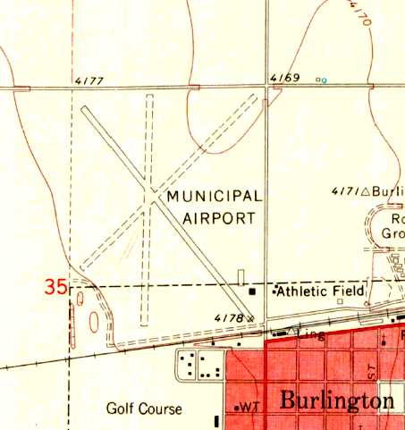
as the 1969 USGS topo map depicted the field as having a paved northwest/southeast runway, along with 2 unpaved strips.
Two small buildings (hangars?) were depicted at the southeast corner of the field.
The 1972 Flight Guide (courtesy of Chris Kennedy) depicted Burlington as having a 3,600' paved Runway 13/31,
in addition to 2 slightly shorter unpaved strips.
A ramp with 2 small buildings (hangars?) was depicted at the southeast corner of the field.
The 1976 AOPA Airport Directory (courtesy of Chris Kennedy)
listed the operators as Don Thompson & James Wear.
The 7/17/81 FAA Inspection Report (courtesy of David Field)
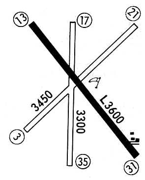
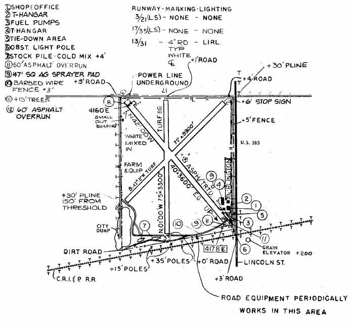
depicted Burlington Municipal Airport as having a 3,600' asphalt Runway 13/31 along with 2 shorter turf crosswind runways.
A shop, office, and 2 T-hangars were depicted on the southeast side of the field.
The manager was listed as Harlie Hahn.
Burlington was said to have 15 single-engine aircraft based at the field,
and it was said to conduct 1,012 takeoffs or landings per month.
The 1982 AOPA Airport Directory (courtesy of Ed Drury)
describe the runway configuration at Burlington Municipal
as a single 3,600' asphalt Runway 13/31 along with 2 slightly shorter unpaved strips.
The operator was listed as Dice Aviation.
In 1984, the new Kit Carson County Airport was opened 3 miles south of Burlington
(at a less constrained site which permitted a longer runway).
The original Burlington Municipal Airport was abandoned on 7/11/84,
according to the FAA Inspection File (according to David Field).
As seen in the 1993 USGS aerial photo,
some kind of sand or concrete processing facility
had been constructed over the southern portion of the former airport property.
However, the entire length of the paved runway at Burlington still existed in fairly decent condition,
with closed-runway "X" markings still visible on the pavement,
as well as the majority of the 2 unpaved runways.
Furthermore, the 2 former hangars also remained standing,
on the southeast corner of the property.

A 9/24/11 aerial view showed that further redevelopment had occurred on the airport property,
but the entire length of the paved runway at Burlington still remained recognizable.
The site of Burlington Municipal Airport is located northwest of the intersection of Colorado Avenue & Lincoln Street.
Thanks to Chris Kennedy for pointing out this airfield.
____________________________________________________
Rocky Ford Auxiliary AAF #1, Rocky Ford, CO
38.14, -103.69 (Southeast of Denver, CO)
The earliest photo which has been located of Rocky Ford Aux #1
was a circa 1943 aerial view looking north from the 1945 AAF Airfield Directory (courtesy of Scott Murdock).
This airfield was apparently built by the government during WW2,
and was not a prewar civilian airfield,
as no airfield at the location was listed in The Airport Directory Company's 1937 Airports Directory (courtesy of Bob Rambo).
Rocky Ford Aux AAF #1 was one of 3 auxiliary airfields used during WW2
by the Four Engine Advanced Flying School at La Junta AAF,
which conducted multi-engine training in the B-25, AT-17, and UC-78 (according to Ken Barber).
The other 2 auxiliary airfields used by La Junta AAF were
Las Animas Auxiliary #2 (6 miles north-northwest of Las Animas, CO),
and Arlington Auxiliary #4 (3 miles east of Arlington, CO).
The federal government acquired a total of 1,560 acres for Rocky Ford Auxiliary Field #1 in 1943-44.
It was much bigger than the typical WW2 training airfield,
as it was used for the training of heavy bombers.
The airfield consisted of 3 asphalt/concrete 6,300' runways,
along with a control building & a maintenance shed.
The earliest photo which has been located of Rocky Ford Aux #1
was a circa 1943 aerial view looking north from the 1945 AAF Airfield Directory (courtesy of Scott Murdock).
It depicted “La Junta Army Air Field Auxiliary #1 (Rocky Ford Field)” as having 3 paved runways.
"Rocky Ford Aux #1, Army" was described by the 1944 US Army/Navy Directory of Airfields (courtesy of Ken Mercer)
as having a 6,000' hard-surface runway.
Rocky Ford Aux #1, as depicted on the 1944 Denver Sectional Chart (courtesy of Chris Kennedy).
The 1945 AAF Airfield Directory (courtesy of Scott Murdock) described “La Junta Army Air Field Auxiliary #1 (Rocky Ford Field)”
as a 1,620 acre rectangular property having 3 bituminous 6,000' runways.
The field was said to not have any hangars, to be owned by private interests, and operated by the Army Air Force.
Rocky Ford Aux #1 was declared surplus in 1946,
and accountability was assumed by the War Assets Administration in 1947.
A former landowner reported that the Town of Ordway took possession of the site after the war,
removed the buildings from the site, and placed them on its city airport.
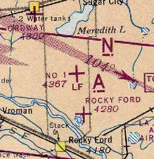
The 1949 Denver Sectional Chart (courtesy of Chris Kennedy)
depicted the former Rocky Ford Aux #1 as one of 2 "Ordway" Airports, which must have led to some confusion.
It described the field as having a 6,000' hard-surface runway.
Control of the site was taken from the Town of Ordway by the Civil Aeronautics Board
after a complaint was filed by the former landowner stating the site was not being maintained as an airport.
The site was then given by the Civil Aeronautics Board to the General Services Administration.
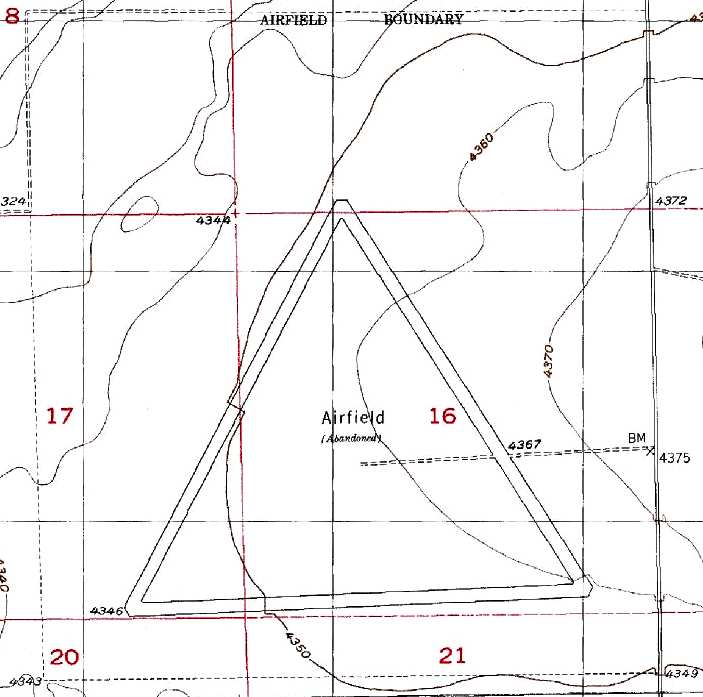
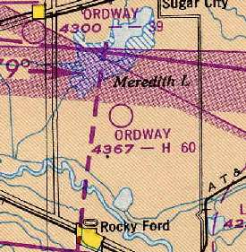
The 1955 USGS topo map 1955 depicted the 3 runways of Rocky Ford Aux #1 labeled simply as “Airfield (Abandoned)”.
Rocky Ford Aux #1 was depicted as an abandoned airfield
on the October 1963 Sangre De Christo Mountains World Aeronautical Chart (courtesy of Donald Felton).
The Rocky Ford Airfield was labeled "Airfield (Abandoned)" on the 1976 USGS topo map.
A 1992 Army Corps of Engineers report said that
"GSA controlled the site for several years before it was auctioned,
reacquired by the former landowner, and resold approximately 2 years ago to the current property owner."
During their 1992 visit, the Army Corps of Engineers found that the 3 asphalt/concrete runways
were the only remaining military improvements.
The report stated that the runways "…are not beneficially used by current owners",
and added that "The runways are in poor condition."
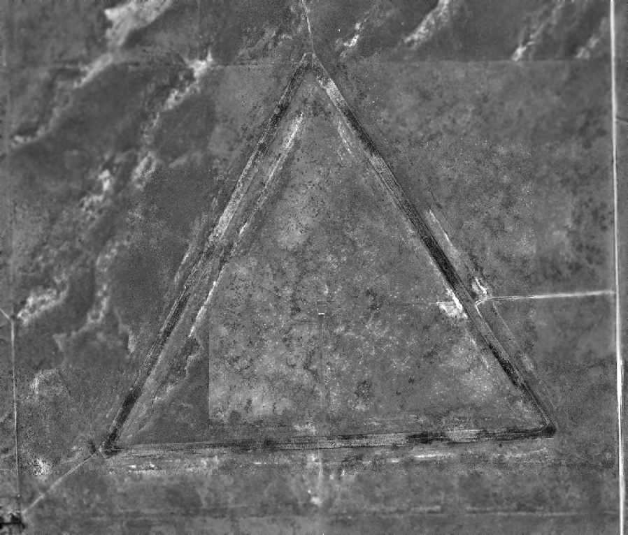
As seen in the 1998 USGS aerial photo,
the 3 large runways of the Rocky Ford Aux #1 Airfield remained quite recognizable.
Just like Las Animas Airfield, this airfield was not depicted at all (even as an abandoned airfield) on 2002 aeronautical charts,
which is strange for such a big field.

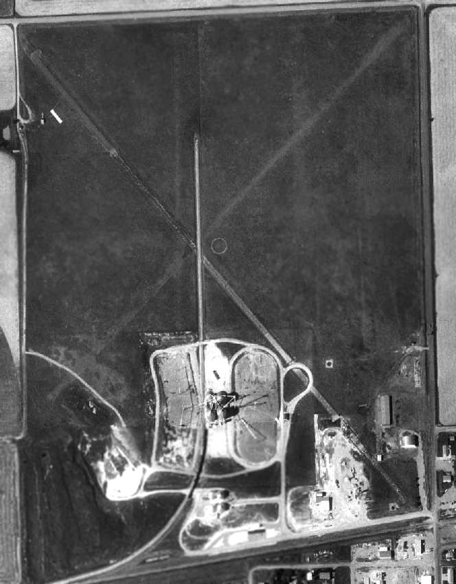
A 10/21/12 aerial view showed the Rocky Ford airfield to remain remarkably intact.
The Rocky Ford Airfield is located west of Route 22,
seven miles north-northeast of Rocky Ford, CO.
____________________________________________________
Las Animas Auxiliary AAF #2, Las Animas, CO
38.15, -103.27 (Southeast of Denver, CO)
The Las Animas Airport, as depicted on the 1936 Trinidad Sectional Chart (courtesy of Scott O'Donnell).
The date of construction of this airfield is unknown.
It was apparently built as a civil airfield prior to 1934,
as the 1934 Department of Commerce Airport Directory (according to Chris Kennedy)
described Las Animas Airport as being in an "L" shape, with 2 sod runways, with the entire field measuring 3,960' x 2,640'.
The directory also had a curious comment about the field: "Rifle butts in northwest corner."
Las Animas was depicted as an auxiliary airfield
on the 1936 Trinidad Sectional Chart (courtesy of Scott O'Donnell).
The Airport Directory Company's 1937 Airports Directory (courtesy of Bob Rambo)
described Las Animas Auxiliary Airfield as consisting of a 3,960' x 2,640' sod landing area.
The site was then reused during WW2 to build a much larger military airfield, Las Animas Aux AAF #2.
Between 1943-44, the federal government acquired a total of 1,446 acres for Las Animas Auxiliary Field #2.
They constructed runways, taxiways & aprons, a control building, and a maintenance shed.
Las Animas Aux AAF #2 was much bigger than the typical WW2 training airfield,
as it was used for the training of heavy bombers.
The airfield consists of 3 paved runways, with the longest being 7,400'.
Las Animas Aux AAF #2 was one of 3 auxiliary airfields used by
the Advanced Flying School at La Junta AAF (16 miles southwest),
which conducted multi-engine training in the B-25, AT-17, and UC-78 (according to Ken Barber).
The other 2 auxiliary airfields used by La Junta AAF were
Rocky Ford Auxiliary #1 (7 miles north-northeast of Rocky Ford, CO),
and Arlington Auxiliary #4 (3 miles east of Arlington, CO).
The earliest photo which has been located of Las Animas Aux #2
was a circa 1943 aerial view looking south from the 1945 AAF Airfield Directory (courtesy of Scott Murdock).
It depicted “La Junta Army Air Field Auxiliary #2 (Las Animas Field)” as having 3 paved runways.
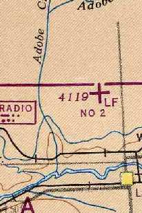
The Las Animas airfield was labeled simply "LF" on the 1944 Denver Sectional Chart (courtesy of Chris Kennedy).
"Las Animas Aux #2, Army" was described by the 1944 US Army/Navy Directory of Airfields (courtesy of Ken Mercer)
as having a 7,000' hard-surface runway.
The 1945 AAF Airfield Directory (courtesy of Scott Murdock) described “La Junta Army Air Field Auxiliary #2 (Las Animas Field)”
as a 1,446 acre square-shaped property having 3 bituminous runways, the longest being a 7,000' northeast/southwest strip.
The field was said to not have any hangars, to be owned by private interests, and operated by the Army Air Force.
The entire installation at Las Animas Aux #2 was reported as surplus to the needs of the Army Air Forces in 1946,
and accountability was assumed by the War Assets Administration in 1947.
After being abandoned by the military,
Las Animas Aux #2 was apparently reopened at some point between 1947-49 as a civil airfield,
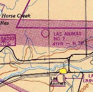
as that is how it was depicted on the 1949 Denver Sectional Chart (courtesy of Chris Kennedy).
It was described as having a 7,000' hard-surface runway.
Las Animas #2 was apparently abandoned (again) at some point between 1949-55,
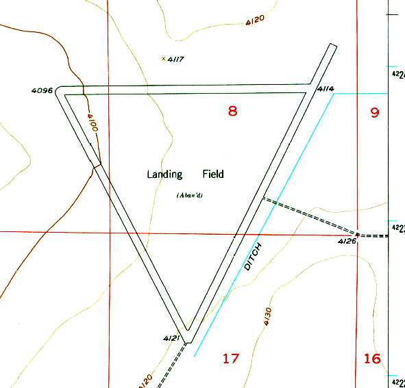
as it was labeled simply as “Landing Field (Aban'd)” on the 1955 USGS topo map.
Las Animas #2 was depicted as an abandoned airfield
on the October 1963 Sangre De Christo Mountains World Aeronautical Chart (courtesy of Donald Felton).
The Las Animas Airfield was labeled "Landing Field (Abandoned)" on the 1976 USGS topo map.
The Army Corps of Engineers conducted a visit to the site in 1992,
and found that the only remains at the site were the concrete foundation of the control building & the runways,
which were described as being "in poor condition".
The former airfield control building & maintenance shed had been removed from their location by the current property owner.
Strangely, the Las Animas Airfield was not depicted at all on 2002 aeronautical charts,
even as an abandoned airfield, which is quite unusual for such a big field.
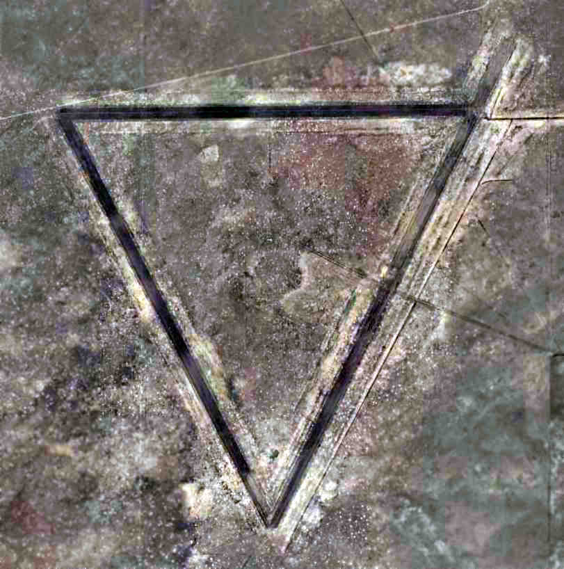
As seen in a 2005 aerial photo, the 3 former runways of the Las Animas airfield remained quite recognizable.
Jeris Danielson reported in 2006, “We visited what we believe to be Las Animas AAF Auxiliary #2 today
and have taken pictures of the north/south runway,
the access taxiway from this runway to the Operations area in the center of the triangle formed by the 3 runways,
several photos of tiedowns adjacent to the Ops building,
a photo of what I believe to have been a concrete block for the generator providing power to the Ops center
(this is a guess from an old Corps of Engineers Colonel who built a lot of aux airfields in Vietnam)
and a photo of the foundation of Ops/Maintenance building.
This site is on the ranch of a dear friend of mine whose father owned about 80,000 acres including this site.
She remembers her brothers riding their bicycles on the runway as it was the only paving in Bent County!
Her father clearly related to her his remembrance of the air operations conducted there in 1942-44.
We found lots of rusty C-ration cans, cable and other debris
that I assume were part of the day-to-day routine of the personnel using the facility.”
The Las Animas Airfield is located northwest of the intersection of Route 10 & Road MM,
six miles north-northwest of Las Animas, CO.
____________________________________________________
Arlington Auxiliary AAF #4, Arlington, CO
38.33, -103.27 (Southeast of Denver, CO)
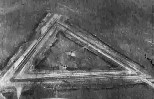
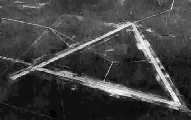
A 1943 aerial view looking northeast at Arlington Aux #4 from the 1945 AAF Airfield Directory (courtesy of Scott Murdock).
This was one of 3 auxiliary airfields used during WW2
by the Advanced Flying School at La Junta AAF (16 miles southwest),
which conducted multi-engine training in the B-25, AT-17, and UC-78 (according to Ken Barber).
The other 2 auxiliary airfields used by La Junta AAF were
Rocky Ford Auxiliary #1 (7 miles north-northeast of Rocky Ford, CO),
and Las Animas Auxiliary #2 (6 miles north-northwest of Las Animas, CO).
The earliest photo which has been located of Arlington Aux #4
was a circa 1943 aerial view looking northeast from the 1945 AAF Airfield Directory (courtesy of Scott Murdock).
It depicted “La Junta Army Air Field Auxiliary #4 (Arlington Field)” as having 3 paved runways.
"Arlington Aux #4, Army" was described by the 1944 US Army/Navy Directory of Airfields (courtesy of Ken Mercer)
as having a 7,000' hard-surface runway.
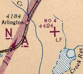
The Arlington airfield was labeled simply "LF" on the 1944 Denver Sectional Chart (courtesy of Chris Kennedy).
The 1945 AAF Airfield Directory (courtesy of Scott Murdock) described “La Junta Army Air Field Auxiliary #4 (Arlington Field)”
as a 1,440 acre square-shaped property having 3 bituminous runways, the longest being a 7,000' northeast/southwest strip.
The field was said to not have any hangars, to be owned by private interests, and operated by the Army Air Force.
After WW2, Arlington Aux #4 was apparently abandoned by the military.
It is not known if Arlington was ever reused for civilian aviation, but it appears as if it was not,
as it was not depicted at all on the 1949 Denver Sectional Chart (courtesy of Chris Kennedy).

A 9/8/54 1998 USGS aerial photo showed the Arlington airfield to remain intact, though without any sign of recent usage.

“Arlington Air Force” was depicted as an abandoned airfield on the 1958 USGS topo map.
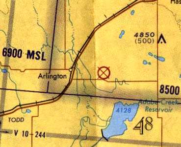
Arlington Aux #4 AAF was depicted as an abandoned airfield on the 1971 Wichita Sectional Chart (courtesy of Vince Granato).
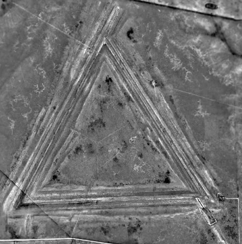
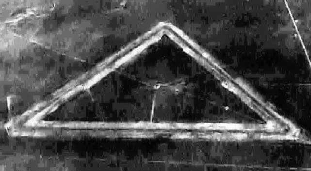
As seen in the 1998 USGS aerial photo,
the Arlington airfield consisted of 3 runways arranged in a triangle, with the longest being 7,000'.
Although somewhat deteriorated, the outline of the airfields was still plainly recognizable.
Just like the other WW2-era La Junta auxiliary airfields,
Arlington was not depicted at all (even as an abandoned airfield) on 2003 aeronautical charts,
which is quite strange for such a big field.
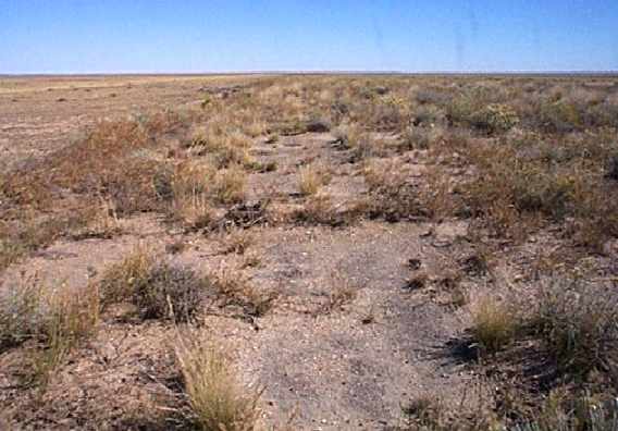
A 2005 photo by Leigh Hettick, looking north along the remains of what would have been Runway 08 or 09 at Arlington Aux #4.
Leigh reported, “You can see the runway outline primarily due to the slight grade change & the difference in vegetation.
Interestingly there's more vegetation on the old runways than the range land beside it.
When you look at the old asphalt, you can see these runways were built to handle the B-17's & B-24's that flew in this area.”
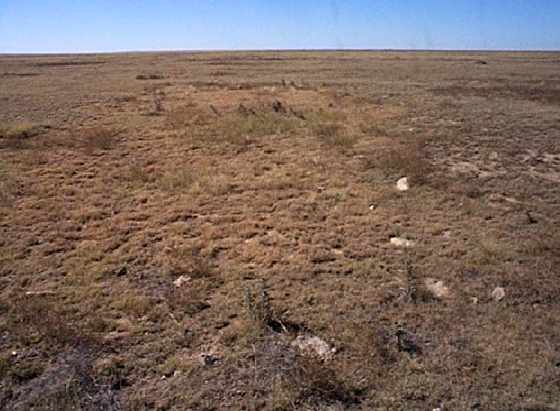
A 2005 photo by Leigh Hettick, looking “where the old operations/control building was in the center of the 3 runways.
In the 1980s you could see the skeleton of the structure when you flow over,
but it's gone now with just some broken bits of cement & clay pipe left.”

A 10/21/12 aerial view showed the Arlington airfield to remain remarkably intact.
Arlington Auxiliary Airfield is located north of County Highway E,
three miles east of the town of Arlington.
____________________________________________________
Since this site was first put on the web in 1999, its popularity has grown tremendously.
That has caused it to often exceed bandwidth limitations
set by the company which I pay to host it on the web.
If the total quantity of material on this site is to continue to grow,
it will require ever-increasing funding to pay its expenses.
Therefore, I request financial contributions from site visitors,
to help defray the increasing costs of the site
and ensure that it continues to be available & to grow.
What would you pay for a good aviation magazine, or a good aviation book?
Please consider a donation of an equivalent amount, at the least.
This site is not supported by commercial advertising –
it is purely supported by donations.
If you enjoy the site, and would like to make a financial contribution,
you
may use a credit card via
![]() ,
using one of 2 methods:
,
using one of 2 methods:
To make a one-time donation of an amount of your choice:
Or you can sign up for a $10 monthly subscription to help support the site on an ongoing basis:
Or if you prefer to contact me directly concerning a contribution (for a mailing address to send a check),
please contact me at: paulandterryfreeman@gmail.com
If you enjoy this web site, please support it with a financial contribution.
please contact me at: paulandterryfreeman@gmail.com
If you enjoy this web site, please support it with a financial contribution.
____________________________________________________
This site covers airfields in all 50 states.