
Abandoned & Little-Known Airfields:
Illinois: Central Chicago area
© 2004, © 2016 by Paul Freeman. Revised 12/3/16.
This site covers airfields in all 50 states: Click here for the site's main menu.
____________________________________________________
Please consider a financial contribution to support the continued growth & operation of this site.
Checkerboard Field / Maywood Airmail Field / Hines Field (revised 9/27/16) - Eagle Flying Field / Elmhurst Airport (revised 12/3/16)
Meigs Field (revised 9/27/16) - Mitchell Field (revised 3/27/16)
____________________________________________________
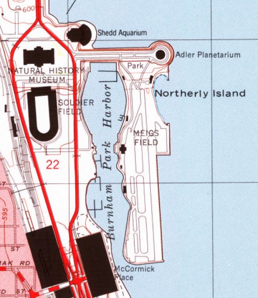
Meigs Field (CGX), Chicago, IL
41.86, -87.61 (East of Downtown Chicago)
A 1947 photo (courtesy of Mark Hess) of what was evidently the Meigs Field groundbreaking ceremony.
Plans for a lakefront airport for the city of Chicago go back to at least 1916,
when Edward Bennett (co-author of Burnham & Bennett's Master Plan of Chicago) first proposed airport on Chicago's lakefront.
In a 1916 letter, Bennett proposed, "The lakefront appears to offer a site naturally adapted for [airport] terminal facilities.
A site on the lakefront would appear also to be more conveniently placed
than any other large area available within a short distance of the central business district."
In 1920, the Chicago public approved a bond referendum to pay for construction of Chicago's lakefront.
Construction began on Northerly Island in 1922,
the same year that Mayor William Hale Thompson advocated locating the downtown airport there.
By the late 1920's consensus had grown.
The South Park Commission had voted to place Chicago's downtown airport on Northerly Island.
The business community concurred.
The Chicago Association of Commerce, in it's 1928 publication "Chicago - The Aeronautical Center" declared that:
"The city of Chicago has recently taken steps that are expected to lead
to an early agreement between the city, the South Park Commissioners & other parties
to the Lake Front Improvement Ordinance of 1919 which will make it possible for the South Park Commissioners
to proceed with the actual construction of the airport."
When the Great Depression hit in 1929, many grand civic plans were put on hold.
The plan for Chicago's downtown airport was postponed
but construction began on the first island, named Northerly Island.
A Planetarium was to be constructed on this island as well as an Aquarium on the Shore.
Then, in a bold move to pull itself up by its bootstraps, Chicago decided to host a world's fair.
In 1933, the Century of Progress fair opened on Chicago's lakefront,
built on Northerly Island & the south lakefront.
Aviation was a theme of the fair, with aircraft of all types featured.
The arrival of Italo Balbo's aerial flotilla to the fair was commemorated
with a monument that still stands in Burnham Park across the harbor from Meigs Field.
Blimps and airplanes plied the skies over the fair;
one attraction featured seaplane rides in Sikorsky S-38's owned by Pal-Waukee Airport.
Shortly after the fair closed in 1934, plans were made once again for a lakefront airport.
The Chicago City Council and Illinois State Legislatures passed resolutions to create the airport
and plans were advanced for as many as 3 runways for the airport.
Yet the combination of a poor economy, uncertainty over world events,
and mixed civic feelings over the use of the lakefront for an airport delayed construction.
In 1941, a report of the Chicago Aero Commission recommended once again
that the downtown airport be located on or near Northerly Island.
Finally, in 1946, the years of waiting ended.
The decision to build an airport on Northerly Island was finalized,
a long term lease with the Chicago Park District was signed, and construction begun.
The size of Northerly Island in 1946 was not sufficient to accommodate
the advances in aircraft & airport designs since construction of the original landfill,
so the Illinois state legislature granted an additional 24 acres of lake bottom,
nearly 1/3 of Meigs' current area, for construction of an airport.
A 1947 photo (courtesy of Mark Hess) showed several unidentified men with shovels
for what was evidently the Meigs Field groundbreaking ceremony.

A 1947 photo of a Stinson Reliant landing at Meigs, on what appears to be a runway still under construction.

An aerial view of the Grand Opening of Meigs, from the 12/11/48 issue of the Chicago Herald-American.
Meig's construction took over 2 years, culminating with a grand opening on 12/10/48.
Despite sub-freezing temperatures, the opening was attended by nearly 100 aircraft, including over 75 Flying Farmers.
The celebration was attended by many city & aviation leaders,
including Mayor Kennelly, Merrill Meigs, and Stuart Symington, Secretary of the Air Force.
Festivities included the dropping of 51 glass bottles containing store gift certificates into Chicago's harbor
from a Cessna 170 flown by Mr. & Mrs. John Wilson of Lockport, IL.
According to the Chicago Tribune, the best speech of the day was made by Lee Talladay,
a Flying Farmer from Milan, MI.
"I didn't expect when I got up & milked the cows at 4 o'clock this morning
to be rubbing elbows over lunch with the brass hats from Washington & the tycoons from Chicago's State Street stores.
But that just shows what can happen when aviation really comes into its own
as it has in this small instance of Chicago's lake front strip," said Talladay.

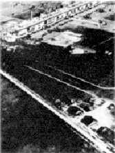
An aerial view looking southeast at Meigs Field soon after its opening in 1948.

A 1948 photo (courtesy of Mark Hess) of a large number of aircraft & spectators at Meigs Field.

A poster promoting the 6/30/50 Dedication of Meigs Field.

A 1950 map (courtesy of Kevin Walsh) depicted Meigs Field as having a single north/south runway.

A 1951 street atlas (courtesy of Kevin Walsh) depicted Meigs Field as having a single north/south runway.

A 1952 aerial view depicted Meigs with its original 2,800' runway.
Five planes were parked in front of the terminal on the northwest side,
and another 10 planes were parked on a ramp on the northeast side.

The 1953 IL Airport Directory (courtesy of Lee Corbin) depicted Meigs Field as having a single north/south paved 2,800' runway.
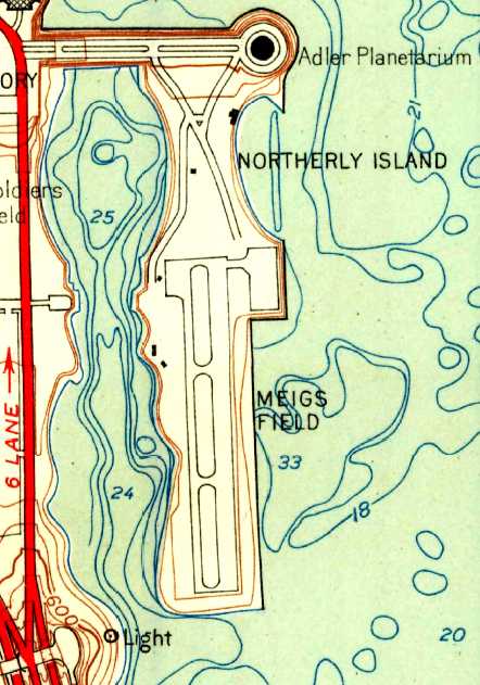
The 1953 USGS topo map depicted Meigs with its original 2,800' runway.
In 1955, Meigs' single runway was extended from 2,800' to its ultimate length of 3,900'.
A 1955 photo of a variety of business aircraft at Meigs Field.

A 1956 aerial view (courtesy of Mark Hess) looking northwest at Meigs Field.

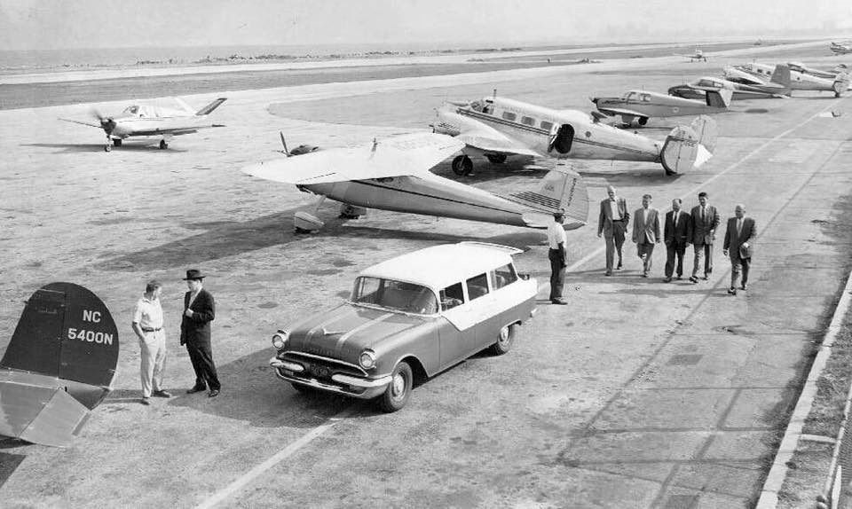
A 10/1/59 aerial view (courtesy of Mark Hess) looking southwest at s busy Meigs Field ramp,
showing dozens of general aviation & business aviation aircraft.
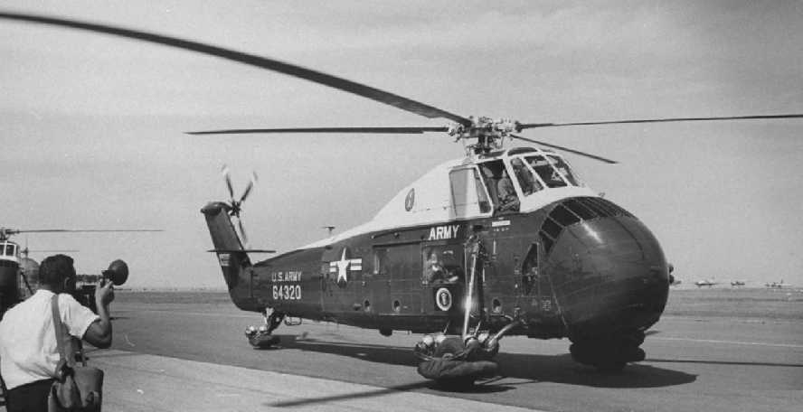
A July 1960 photo by Ed Clark of President Dwight Eisenhower's Sikorsky VH-34 at Meigs Field.

A 10/19/61 photo (courtesy of Mark Hess) of a Bell 47 in front of the new Meigs terminal building, presumably decorated for its dedication.
Mayor Richard Daley dedicated a new Meigs Field passenger terminal building in 1961.

A circa 1961 aerial view from the 1962 IL Airport Directory (courtesy of Jonathan Westerling)
depicted Meigs' newly lengthened runway, measuring 3,710' with a 235' paved overrun.
It also showed a large number (dozens) of aircraft parked on the field.
The operators were Butler Aviation & Chicago Helicopter Airways,
and the manager was listed as William O'Brien.
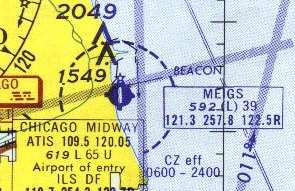
The June 1962 Chicago Sectional Chart (courtesy of William Pagett)
depicted Meigs as having a single 3,300' paved runway.
In 1962, an expansion of the airport was proposed,
including a 5,000' runway & additional aircraft parking on the east side, but no action was taken.

Two undated postcard photos (courtesy of Benton Bullwinkel) of Meigs Field (the top photo had a date of 1964 on the back).

A circa 1964-77 aerial view looking northwest at a Cessna 150 having just departed from Meigs Field's Runway 18, from a Cessna 150 brochure (courtesy of Alex Hauzer).

The 1968 Flight Guide (courtesy of Robert Levittan) depicted Meigs Field as having a 3,948' paved Runway 18/36.
The 1969 Chicago Sectional Chart depicted Meigs as having a single 3,900' paved runway.
In 1972, Mayor Richard Daley proposed Meigs' closure (what would ultimately become the first of many proposals),
but he backed down when threatened with the loss of federal FAA funding.

A circa 1973-74 photo by Bob Coveney looking north at Meigs Field, showing a Bell Jet Ranger, Bell 47, and several light aircraft.
Bob recalled, “We'd stop here for fuel on the way back from the Nike missile sites that were south of Chicago.”

A 1970s photo of 2 vintage biplanes at Meigs Field.

The last aeronautical chart depiction which has been located of Meigs Field
was on the May 1973 Chicago Terminal Aeronautical Chart (courtesy of Mitchell Hymowitz).
It depicted Meigs as having a 3,900' paved runway.
In 1980, Mayor Byrne proposed Meigs' closure for the 1992 World's Fair, another proposal which fortunately was not carried out.

A 7/28/84 photo of the Chicago Fire Department's N441FD, a 1961 Bell UH-1B, serial #371, at Meigs Field.
In 1989 the City of Chicago accepted FAA funding for Meigs,
along which Mayor Daley signed a grant agreement
pledging to seek purchase or lease extension of the airport property to 2009.
On October 15, 1992 a Boeing 727 that was donated from United Airlines to the Chicago Museum of Science & Industry
made its final landing at Meigs, on its way to be transported to the museum to become an exhibit.
This was notable because Meigs' runway was somewhat shorter than that used typically by a 727,
but the lightly-loaded jet did not require all of the runway.
The 727 was then barged off the airport, prepared for exhibit & eventually further barged to the museum.
In 1992, the City Department of Aviation published its intent to close the airport in its annual report.
What a progressive & supportive Department of Aviation.
That threat was carried out in September of 1996,
when the Park District & Department of Aviation closed Meigs (for the 1st time).
A sad day for Chicago-area aviators,
and a very bad precedent for aviation in general.
However, within 2 months, the State Legislature voted to reopen the airport under state control.
In January 1997, Governor Edgar & Mayor Daley struck a bargain:
Meigs would reopen for 5 years, with the City retaining control of the airport.
The agreement did not require the airport to close at the conclusion of the 5 year period.
Meigs was given a new lease on life when in reopened in February of 1997.
In February 1998, Meigs received its first instrument approach procedure,
ending Chicago's reign as only major American city without an instrument approach procedure to its nearest downtown airport.
Meigs Field, as depicted on the 1998 USGS topo map.

A November 1998 view looking northeast at the Meigs ramp, showing 3 Cessna Citation jets & 2 Beech King Airs.
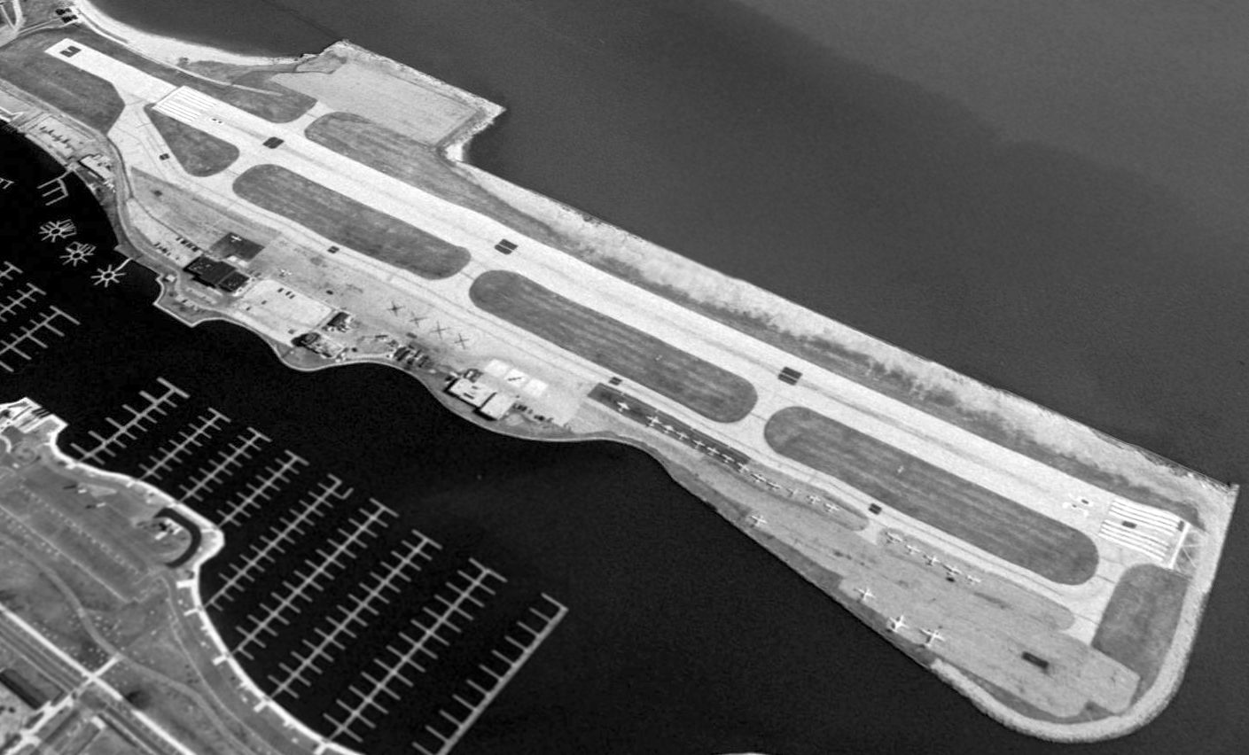
A 1999 USGS aerial view looking northeast, showing Meigs only 4 years before it was closed again.
Note the presence of over 2-dozen aircraft on the ramp,
but that the runway had been shortened to 3,500', with the northern threshold moved by 500'.

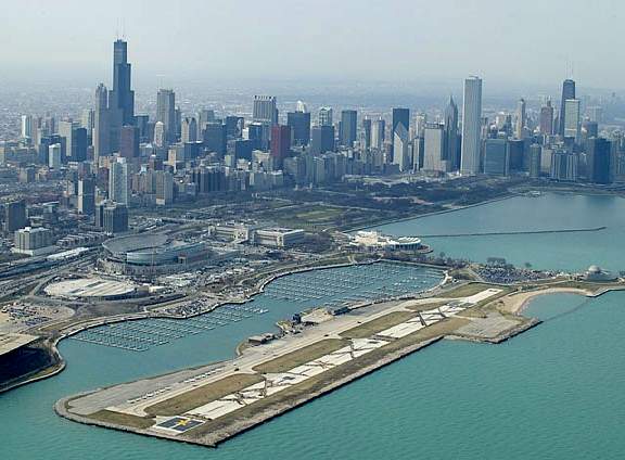
A beautiful September 2001 aerial view of Meigs by Dave Sims.

A 7/2/02 photo of a Cessna Citation II landing at Meigs Field by Zach Gollman.

The last photo which has been located showing Meigs while still in operation was a 12/30/02 aerial view looking northeast,
showing a large number of aircraft on the ramp.
The photo was taken only 3 months before the airport was destroyed in the middle of the night by the city's own government.
In its last years, it was estimated that Meigs Field contributed a minimum of 1,500 jobs
and $57.3 million annually to the local economy.

A 2003 aerial photo looking southeast at the destruction of Meigs Field -
carried out in the middle of the night by order of Mayor Daley in 2003.
A 2003 aerial photo looking northwest at the destruction of Meigs Field -
carried out in the middle of the night by order of Mayor Daley in 2003.
An outrage!
The above photos should sicken the stomach of anyone who believes in elective democracy & the rule of law.
On the night of March 31, 2003, under the cover of darkness & without any prior public notification,
the Mayor of Chicago, Richard Daley, sent in city bulldozers with police escort to destroy only runway at Meigs Field,
a publicly-owned general aviation airport.
All aircraft based at the field were stranded,
and the public (including rent-paying owners of aircraft based at Meigs)
were barred entrance to the property.
Daley had wanted to close the airport for years, even though it served as a desperately-needed reliever airport,
diverting business & private aircraft traffic away from already-choked O'Hare & Midway Airports.
Many municipalities would love to have such an airport with millions of dollars of paid-for aviation infrastructure,
yet Daley decided that he should destroy the infrastructure owned by his constituents.

A 2005 aerial photo by Ron Plante – showing that all of the publicly-paid-for runway infrastructure at Meigs Field has been completely destroyed.

A circa 2006 aerial view looking east at the former Meigs Field control tower.

A circa 2006 aerial view looking east at the former Meigs Field terminal building.

An April 2006 photo by Tobias Rad looking west at the former Meigs Airport terminal building.

An August 2013 photo by Kevin Raab looking northeast at the former Meigs Field control tower.
Kevin reported, “The the old control tower is not open to the public.”

An August 2013 photo by Kevin Raab looking southwest at the former Meigs Field terminal building.
Kevin reported, “Most of the land where the runway & taxiways used to be is fenced off & a park/wildlife area of some sort is currently under construction.
I was unable to find any signage anywhere commemorating the picturesque little airport that once was there.”

An August 2013 photo by Kevin Raab of the interior of the former Meigs Field terminal building.
Kevin reported, “The old terminal building is partially open to the public.”
Marty Coddington reported, “I was always a crusader for airports. Once they are gone...
The CGX thing still has me angry. Mayor Daily Sr. must be rolling in the grave. He was very proud & protective of CGX.”

A 2015 aerial view looking northeast at the site of Meigs Field shows that an amazing amount of tax dollars have been spent to completely remove the airport infrastructure,
and therefore eliminate any chance that the site would once again be able to serve as an airport.
To express your displeasure over the destruction of Meigs Field,
contact Mayor Daley at mayordaley@cityofchicago.org, 312-744-3334.
The history of Meigs, and details of the fight to reopen the field,
have been covered in great detail at the web site of The Friends of Meigs Field.
____________________________________________________
Eagle Flying Field / Elmhurst Airport, Elmhurst, IL
41.926, -87.962 (Southwest of Chicago O'Hare International Airport, IL)

“Elmhurst Greer College” Airport, as depicted on the 1930 Chicago Sectional Chart.
According to the Elmhurst Historical Museum, “Elmhurst Airport, originally covering 160 acres,
was located between Lake Street & Grand Avenue & between Church Road & Route 83.
It started when Chicagoan Joe James landed his biplane on a tract of land in north Elmhurst in 1923.
James & Elmhurst resident Fred Bouchard founded & operated the 'Eagle Flying Field' until James left in 1929.
That same year, the Elmhurst Airport was incorporated.
The airport had flight schools, commercial & private planes & support services.
The Elmhurst Press carried ads & articles about the airport.
One 1929 ad encouraged readers to join the 'Humming Bird' flying club, offering free flight instruction.”
The earliest depiction which has been located of Elmhurst Airport was on the 1930 Chicago Sectional Chart,
which labeled it as “Elmhurst Greer College” Airport.

An undated (circa 1930s?) photo of an unidentified biplane at Elmhurst Airport.
The Elmhurst Historical Museum continued, “The airport had 2 grass runways.
There were no runway lights until the last years of the airport's operation,
so pilots making night landings had to judge their distance by 2 flares that marked the end of the runways.
One of the major challenges to pilots flying into & out of the Elmhurst Airport
was a radio tower situated just east of the airport & aligned with one of the runways.”

An undated (circa 1930s?) photo of an unidentified biplane at Elmhurst Airport.

The March 1937 Chicago Sectional Chart (courtesy of Chris Kennedy)
depicted “Chicago Elmhurst” as a commercial/municipal airport.
A 1939 aerial photo showed Elmhurst having 3 grass runways, with several hangars along the south side.
According to the Elmhurst Historical Museum, “With the approach of World War II,
the Civil Aeronautics Administration created a program that was a cooperative effort
between colleges that offered ground study & airports that offered flight instruction in order to fast-track civilians into military service.
Both Elmhurst College & Wheaton College partnered with Elmhurst Airport in this program.
A local unit of the Civil Air Patrol used Elmhurst Airport as a recruiting station.”

A 9/26/43 aerial view looking north from the 1945 AAF Airfield Directory (courtesy of Scott Murdock)
depicted Elmhurst Airport as an open grass area.
The 1945 AAF Airfield Directory (courtesy of Scott Murdock) described Elhmust Airport
as a 100 acre rectangular property having 3 sod runways, the longest measuring 2,700' northwest/southeast.
Elmhurst was said to have 4 hangars (the largest being a 76' x 40' metal structure),
and to be owned & operated by private interests.
According to the Elmhurst Historical Museum, “Tufts-Edgecumbe Co. became the main business & manager of Elmhurst Airport in 1945.
It operated planes, improved the runways, and built training facilities.
It offered civilian classes, flying lessons, sales, and service.”

The last aeronautical chart depiction of Elmhurst Airport which has been located was on the 1946 Chicago Sectional Chart.
It depicted Elmhurst as a commercial/municipal airport.
Also note the depiction of “Orchard Place” airport a mere 3 miles northeast,
which would eventually grow to become O'Hare Airport.
According to Moody Aviation, “In 1946, Moody Aviation began, setting up operations at Elmhurst Airport near Chicago.
In the beginning, courses included Morse code, meteorology, and photography.
In 1950, Moody Aviation transferred operations to Wooddale Airport”

A 4/8/52 USGS aerial view depicted Elmhurst Airport with dozens of light aircraft parked on the south side of 3 unpaved runways.

The 1953 IL Airport Directory depicted Elmhurst Airport as having 3 turf runways, with the longest being the 3,200' northwest/southeast strip.
A row of small hangars was depicted along the south side, and the manager was listed as George Edgecumbe.

A 1953 aerial view looking north at Elmhurst Airport with Lake Street in the foreground,
showing a hangar marked with Elmhurst Airport on the roof & the back, a T-hangar, and 5 planes.

The last map depiction which has been located showing Elmhurst Airport still in operation was on the 1953 USGS topo map.
It depicted Elmhurst as having 4 unpaved runways. It did not depict any buildings on the airport.
Paul Hasz recalled, “In 1953, my parents moved to Oakdale Woods which was across from Elmhurst Airport.
Tthe main buildings were on Lake Street, but a small fixed base operator had an office on Grand Avenue.”
Dave Menard recalled, “Elmhurst Airport... I do not recall any paved runways.
I shot a beautiful Ryan ST there in the summer of 1955.”

The last photo which has been located of Elmhurst Airport depicted it perhaps at its peak of popularity,
with dozens of light aircraft parked on the south & north sides of 3 unpaved runways.
According to the Elmhurst Historical Museum, “Tufts-Edgecumbe remained managers of the airport until the airport closed in 1956
when the owners of the property failed to renew the lease.”
A 1962 aerial photo showed that the Elmhurst airfield remained clear,
and several hangars remained standing along the south side, but there was no sign of any aviation activity.
The 1963 USGS topo map no longer depicted Elmhurst Airport.
A 1974 aerial photo showed that at some point between 1962-74
a large number of commercial buildings had been constructed over the Elmhurst Airport site,
and the hangars had been removed, erasing any trace of the airport.
According to Marilyn Fornell, the Elmhurst Airport property “became the Caterpillar plant.”
According to the Elmhurst Historical Museum, “The property is now part of Elmhurst's industrial park.”

A 7/1/10 aerial photo did not show any trace remaining of Elmhurst Airport.
____________________________________________________
41.92, -88.04 (Southwest of Chicago O'Hare International Airport, IL)

A 1946 aerial view depicted Mitchell Field as having 2 grass runways.
This general aviation airport was originally built out in the open lands before Chicago grew up & consumed it.
Mitchell Field was evidently established at some point between 1945-46,
as it was not yet listed among active airfields in the 1945 AAF Airfield Directory (courtesy of Scott Murdock).
The earliest depiction of Mitchell Field which has been located was a 1946 aerial view.
It depicted Mitchell as having 2 grass runways,
with a hangar & a few small buildings on the east side of the field.
A total of 7 light aircraft were visible around the hangar.
Stormy Hunter reported, “Mitchell Field was listed in the 1948 Chicago & Suburbs Telephone Directory (which I own).
The listing reads: 'Mitchell Field... Columbine Avenue... Lombard-115.'”
Yet Mitchell Field was not yet depicted at all
on the December 1952 Illinois River World Aeronautical Chart (according to Chris Kennedy).
The earliest aeronautical chart depiction of Mitchell Field which has been located
was on the June 1954 Chicago Sectional Chart (according to Chris Kennedy).
It depicted the field as having a 2,800' unpaved runway.
In 1955 the remains of a Stearman-Hammond Y aircraft
(originally designed in circa 1934 as part of a contest to design a "flivver" low cost aircraft)
were located in the home of Carl Dahlin on the perimeter of Mitchell Field,
and shipped to the Smithsonian Institution in Washington.

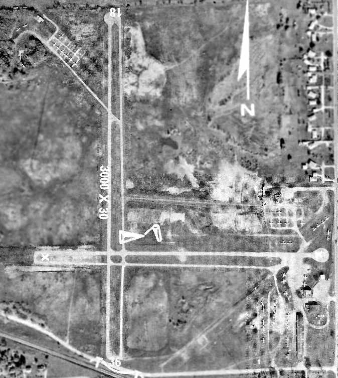
Mitchell Field, as depicted on the 1958 USGS topo map.
The 1960 Jeppesen Airway Manual (courtesy of Chris Kennedy)
depicted Mitchell Field as having 3 unpaved runways, with the longest being the 2,590' Runway 18/36.
The airport property had roughly doubled since 1946,
with the addition of land on the north side of the field for the new Runway 18/36.
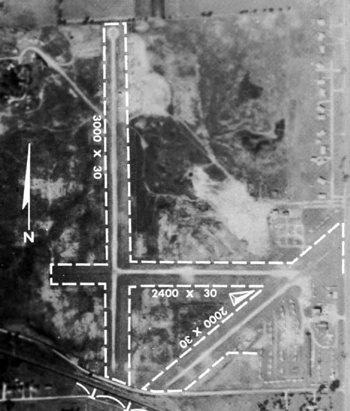
The 1960 IL Airport Directory (courtesy of David Brooks)
depicted Mitchell Field as having a total of 3 gravel & oiled runways,
with the longest being the 3,000' north/south strip.
Dozens of light aircraft were visible parked alongside some small hangars on the southeast corner of the field,
along with a few aircraft parked on the northwest corner of the field.
The manager was listed as K. T. Mitchell,
and the operators were listed as K. T. Mitchell, George Snyder (Snyder Helicopter Service), and Dick Lloyd (Lloyd Flying Service).
Within the next year one of Mitchell's runways was evidently closed,
and the remaining 2 runways were paved,
as the Aerodromes table on the December 1961 Chicago Sectional Chart (according to Chris Kennedy)
described Mitchell as having 2 paved runways, with the longest being 2,590'.
Marie Lloyd Montagne reported that her “first husband, Richard (Dick) Lloyd was the owner & operator of the Lloyd Flying Service.”
She recalled that his flying service moved from “Elmhurst Airport to Mitchell Field in Lombard.”
Stormy Hunter recalled, “In the 1960s, my grandfather Joseph Tucker owned a 1960 Mooney M20A,
and later sold it, and bought a 1966 Mooney M20C.
He kept these planes at Mitchell Field & frequently used to take me with him when he went there.
He didn't always go flying, he sometimes just went to hang out in the pilot's lounge
and shoot the bull with the other plane enthusiasts.
He'd always introduce me as his grandson & I felt very important
as I shook hands with all these pipe-smoking friends of Grandpa Joe's.
The airport had a swimming pool, which I remember was always half-full of stagnant water & dead leaves.
There was also a small restaurant which had a swinging wooden screen door with a huge 'Dr. Pepper' thermometer on it.
There was a pool table inside, and also a jukebox, which was filled with Jack Scott, Duane Eddy, Nat King Cole & the like.”

The 1962 USGS topo map depicted Mitchell Field as having 3 paved runways or taxiways, and several buildings on the southeast side.
In an aerial view of Mitchell Field from the 1962 IL Airport Directory (courtesy of David Brooks),
the official length of the primary north/south runway had been reduced to 2,450',
even though the runway visually looked identical to how it appeared in the earlier photo.
The northeast/southwest runway had been converted to a taxiway, along both sides of which were parked numerous aircraft.
The runway surface of the 2 remaining runways was described as bituminous.
The manager was listed as K. T. Mitchell,
and the operators were listed as K. T. Mitchell, George Snyder (Snyder Helicopter Service), and Dick Lloyd (Lloyd Flying Service).
Brad Sherman recalled, "I lived on the west edge & played on the property frequently,
I also would wash planes for quarters with some of my friends.
I saw several crashes while out playing. Only one fatal one.
Others were just 'dashboard faces'… ugh, not pretty.
The trees on the northwest corner hid several wrecked or abandoned planes that we used to play in.
It might have been where the Stearman was found.
Us kids would set the swamp at the end of the east/west runway on fire in autumn to clear it for that winter's ice skating… big fun.
Watching the fire trucks come from a safe vantage point & put it out after just enough reeds had been burned for a hockey rink.
We built some incredible tree houses in the trees & had campouts.
It was really fun to live next to a small but busy airport in the pre-9/11 days."
"It was packed with planes up until the final days.
Lot of EAA guys I think, couple of 'breezies', things like that.
A restaurant called the Kitty Hawk.. several vintage aircraft.
My neighbor's dad had an AT-6 Texan there & a BT-13, an Aeronca Champ, and a beautiful Cessna 195.
He flew stunts in the air show & would know a lot about the field… a former TWA pilot.
The field had a yearly air show that was fun. Local acrobatic pilots & tours."
Dave Menard recalled, “I have a soft spot for Mitchell Field as that is where I got my first 2 rides in an aircraft, with a good old Piper Cub being the first one.
My father used to repair aircraft radios in our basement & then take them back out to the airport to put back in.
I recall calling O'Hare Tower for radio checks & the thrill when they answered me!
The Nike ground-to-air missile site just across Route 53 from the airport [southeast of Mitchell Field]...
When one turned base to final coming in from the east,
it was usually over the site with the missiles in different states of erection which were impressive to say the least.”

The 1963 Chicago Local Aeronautical Chart (courtesy of David Brooks)
depicted Mitchell field as having a 2,500' hard-surface runway.

The 1968 Flight Guide (courtesy of Robert Levittan) depicted Mitchell field as having 2 paved runways: 3,100' Runway 18/36 & 2,450' Runway 9/27.
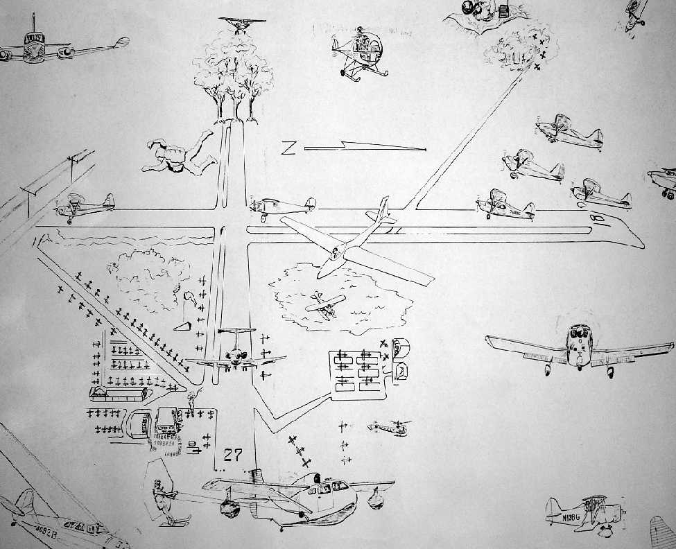
A small portion of a huge undated (pre-1974) poster by Carol Wagner (courtesy of Marty Coddington) entitled “Mitchell Field, Sunday Afternoon”.

A 1971 photo by Marc Stancy looking north at a Cessna 150 taxiing at the south end of Mitchell Field's Runway 36.
The last photo of Mitchell Field which has been located was an aerial view from the 1972 IL Airport Directory (courtesy of Bill Pagett).
The directory depicted the field as having a single 3,000' bituminous Runway 18/36,
along with a closed crosswind east/west runway.
Dozens of light planes were visible parked on the northwest & southeast sides of the field.
The operator was listed as Addison Aviation, with the airport manager being Joe Luppino.

The last depiction of Mitchell Field as an active airport which has been located
was on the May 1973 Chicago Terminal Aeronautical Chart (courtesy of Mitchell Hymowitz).
It depicted Mitchell as having a 2 paved runways, with the longest being 2,500'.
Brad Sherman recalled, Mitchell Field "was closed around 1973.”
Brad Sherman recalled, "A school was built on the northwest corner; DAVEA school.
Governor James Thompson came out & dug the first shovel of dirt.
I always thought of it as the first shovel of the airport's burial.”
Mitchell Field was definitely closed by 1974,
as it was no longer depicted at all on the 1974 Chicago Sectional Chart (according to David Brooks).
A 1974 aerial view showed that the site of the runway had been scraped clean,
and construction for Route 355 (which would eventually go right through the airport property) was approaching from the north.
By the time of the 1998 USGS aerial photo, the former airport had been completely obliterated,
with a major freeway (355) running right through where the field was located.
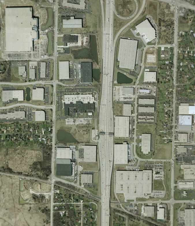
As seen in the 2002 USGS aerial photo, not a trace appears to remain of the former Mitchell Field.
The site of Mitchell Field is located south of the intersection of Route 355 & Army Trail Boulevard.
____________________________________________________
Checkerboard Field / Maywood Airmail Field / Hines Field, Broadview, IL
41.858, -87.84 (Northwest of Chicago Midway Airport, IL)
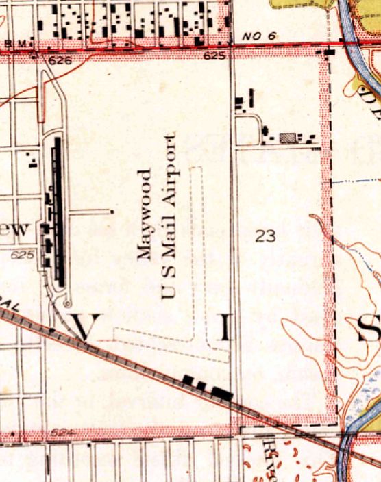
“Maywood U.S. Mail Airport”, as depicted on the 1928 USGS topo map.
In 1919, a company called Society Brand Clothes bought land on the east side of First Avenue between Roosevelt & Cermak Roads,
(in what now is Miller Meadow),
according to the website of the Loyola University Health System.
The airfield was opened by David Behncke & Bert Russell,
according to the Franzosenbusch Heritage Society.
A metal hangar was constructed, and 2 planes were purchased to deliver the company's clothes to towns outside the Chicago area.
Each plane, painted with a checkerboard design, carried large signs advertising Society Brand Clothes.
Since these were the only planes using the field, it was called Checkerboard Flying Field.
Also in 1919, the U.S. Post Office Department extended its air mail service from Cleveland to Chicago.
In the beginning, the mail planes used a portion of Grant Park as a landing field.
However, winds from Lake Michigan made landing precarious,
so a new location had to be found.
Maywood's Checkerboard Field was chosen.
Bud Sherman recalled, “I taught at Morton East High School in Cicero. A few of the old teachers had been students at Morton in the 1920s.
According to them in the 1920s the students in the Industrial Arts Department built an airplane.
They used special machines in the wood shop to bend the wood into the appropriate shapes.
They flew the airplane from Checkerboard Field. How they got there from the school was a question I never thought to ask. It must be at least a distance of 8 miles.
Eventually there was a crash. There were no injuries to personnel, fortunately. However, the school board promptly canceled the program before injures would occur.”
In 1923, a new field was built on the west side of First Avenue, south of Roosevelt Road,
on the grounds of Edward Hines Memorial Hospital.
The new Checkerboard Air Mail Field received Chicago's air mail from Cleveland and Omaha,
and Maywood was the main repair & overhaul center for the entire air mail service, which continued to expand to other cities.
It was also called Maywood Air Mail Field at this time.
In 1923, Behncke sold the field to Wilfred Yackey, a former military and airmail pilot.
From 1923 until Yackey's death in an airplane crash,
the Yackey Aircraft Company & Checkerboard Field were the center of aircraft manufacturing activities in the Chicago area.
On 4/15/26, Charles Lindbergh, the chief pilot for Robertson Aircraft Corporation's Chicago-to-St. Louis airmail route
took off from Maywood on the service's inaugural flight to St. Louis.
As Charles Lindbergh later wrote in Apples of Knowledge, "It took me 2.75 hours to reach St. Louis,
including stops at Peoria & Springfield, Ill.
Hurtling through the air at 90 miles an hour behind my mail sacks,
I thought of the 2 MPH oxcart travel of my father's boyhood."
Lindbergh's Chicago-to-St. Louis trips sometimes were plagued by bad weather or aircraft failure.
Already a 2-time member of the "Caterpillar Club",
a group of pilots who had the distinct honor of owing their lives to parachutes,
he insisted that each pilot on his air mail route be equipped with a parachute in case of emergency.
Five months after his inaugural flight, Lindbergh became a 3-time member of the Caterpillars.
He described his September 1926 flight from St. Louis that didn't quite make it to Maywood in his book, "We".
"The fog extended from the ground up to about 600 feet...
at no time, however, was I able to locate the exact position of the field,
although I understand that the searchlights were directed upward
and 2 barrels of gasoline burned in an endeavor to attract my attention."
When his fuel ran out, about 30 miles from Checkerboard Field,
Lindbergh was forced to parachute from his plane.
However, he had neglected to cut the switches to the plane's engine.
With less weight, the small amount of fuel left in the line drained to the carburetor, and the plane continued to fly.
"The plane was making a left spiral of about a mile diameter,
and passed approximately 300 yards away from my 'chute,
leaving me on the outside of the circle.
I was undecided as to whether the plane or I was descending the more rapidly
and glided my 'chute away from the spiral path of the ship as rapidly as I could.
The ship passed completely out of sight, but reappeared in a few seconds,
its rate of descent being about the same as that of the parachute.
I counted the 5 spirals, each one a little further away than the last, before reaching the top of the fog bank."
In 1927 Checkerboard Field lost its air mail contract due primarily to 2 events.
The U. S. Mail Service started contracting the airmail flights to private companies.
One of the stipulations was that private facilities must be used by the private air mail companies,
but Maywood Air Field was a public field owned by the Village of Maywood.
Furthermore, Wilford Yackey, who ran the Maywood field, died while performing acrobatics in one of his company's monoplanes.
A wing snapped off after a series of dazzling maneuvers & he died in the crash.
Without his enthusiasm & effort the air mail service ceased to use the former Checkerboard Field.
The earliest depiction which has been located of the airport was on the 1928 USGS topo map,
which depicted “Maywood U.S. Mail Airport” as having 2 unpaved runways with 3 buildings along the south side.
An undated aerial photo, showing the hangars of Checkerboard Field at the bottom.
The 1933 USGS topo map depicted “Maywood U.S. Mail Airport” in an unchanged fashion.

A 1933 Rand-McNally map (courtesy of Kevin Walsh) depicted “Checkerboard Aviation Field”
along with the adjacent “Veterans Auxiliary Field” & a beacon to the west.
At some point between 1927-33, the field was evidently renamed as Hines Field.
The Airport Directory Company's 1933 Airport Directory (courtesy of Chris Kennedy)
described Hines as a commercial airfield, having 2 cinder runways in an "L" shape:
2,300' north/south & 1,900' east/west.
The field was said to have hangars at the south end,
and hospital buildings to the west & northwest.
The Department of Commerce's 1934 Airport Directory (courtesy of Chris Kennedy)
described "Hines Field" as the "old air-mail field".
The description of the airfield configuration was identical to that in the 1933 directory.
Bruce Lathrop recalled, "My father remembers watching airmail planes take off & land
at the old airport north of Cermack & west of First Avenue.
The airport was located south of Hines Veterans Hospital."

The last depiction of Hines Field as an active airfield which has been located was
on the March 1937 Chicago Sectional Chart (courtesy of Chris Kennedy).

from the IL Air Photo Imagebase (courtesy of Bruce Lathrop).
But it is not apparent if the airfield was no longer in operation at this point.
Hines Field was evidently closed at some point between 1937-42,
as it was no longer depicted at all on the October 1942 Chicago Sectional Chart (courtesy of Brad Lawrence)
or on subsequent aeronautical charts.

A 1944 map (courtesy of Kevin Walsh) still depicted the “U.S. Mail Air Service Field”, even though it was no longer in use by that point.
The 1945 USGS topo map depicted an unlabeled clearing in the place of the airfield,
but still depicted the 3 buildings along the south side.
A 1951 aerial view showed that the area of the runways had been covered with buildings at some point between 1938-51.

A 1951 street atlas (courtesy of Kevin Walsh) still depicted the “Landing Field”, even though it had ceased to exist by that point.
David Bossert reported in 2005, “I visited the old Checkerboard Airfield site about 3 years ago.
The city had installed a plaque that commemorates the airfield, and briefly describes its history.”

An April 2004 USGS aerial photo shows that the site of the former Hines Field
has been thoroughly covered over by buildings.
However, the 2 original air mail service hangars still remained standing -
the 2 dark colored buildings at the southeast corner of the site.
The site of Hines Field is occupied by the Hines Veterans Hospital & the Loyola Medical Center.
The runway that Lindbergh used on his first flight from Maywood to St. Louis
ended near the present location of the Loyola Lifestar helipad & the new emergency medical building.
John Donat reported in 2005, “The original air mail service hangars from the Hines Airfield exist,
and are in use by the Veterans Hospital for storage & repair of X-Ray equipment.
The buildings are listed in the Illinois historical buildings list.”

A 2005 photo by David Bossert of the “The east building... a very long, brick, 2-story, industrial looking with a flat roof.”
A 2005 photo by David Bossert of the western portion of the east building,
which “has a pitched roof & looks like it was a former hangar,
with the hangar doors replaced by a huge brick wall on the west end.”

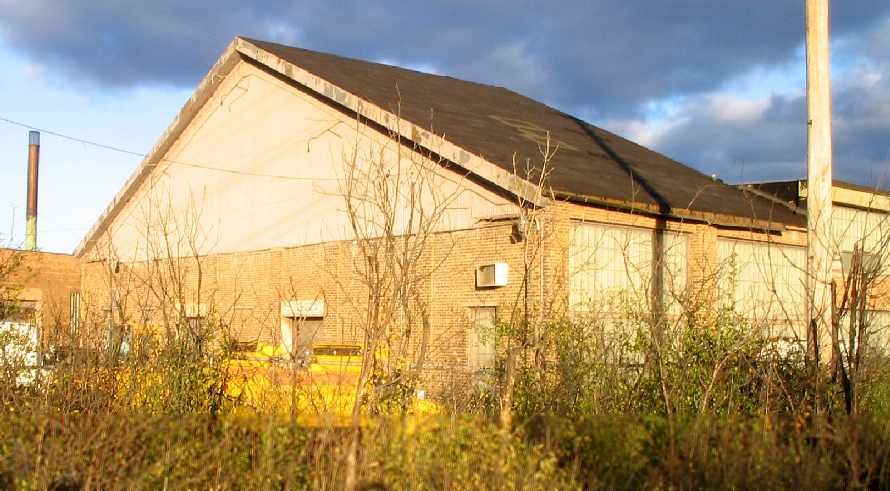
A 2005 photo by David Bossert of “The western building... a pretty large hangar made of corrugated steel,
with hangar doors on the east & west ends.”

A 2005 photo by David Bossert of the “commemorative monument located in the Miller Meadows Forest Preserve,
which borders the east side of Hines Veterans Hospital.
The monument is located 200 ft south of the park entrance off Roosevelt Road, east of First Avenue.
Although the monument claims it marks the site,
the monument is actually located more than a quarter mile east of the most northeast corner of the old field.”

A circa 2006 aerial photo looking south at the 2 original air mail service hangars at the southeast corner of the site.

A July 2012 photo by George Slad “of the north side of the southeast-most structure (former hangar & airmail building.”
George reported, “I spoke with a couple of employees in the building & they were familiar with some of the history of the building & area as it mentioned in new-hire training.”
The site of Hines Field is located north of the intersection of Tripp Avenue & Air Mail Road.
____________________________________________________
Since this site was first put on the web in 1999, its popularity has grown tremendously.
That has caused it to often exceed bandwidth limitations
set by the company which I pay to host it on the web.
If the total quantity of material on this site is to continue to grow,
it will require ever-increasing funding to pay its expenses.
Therefore, I request financial contributions from site visitors,
to help defray the increasing costs of the site
and ensure that it continues to be available & to grow.
What would you pay for a good aviation magazine, or a good aviation book?
Please consider a donation of an equivalent amount, at the least.
This site is not supported by commercial advertising –
it is purely supported by donations.
If you enjoy the site, and would like to make a financial contribution,
you
may use a credit card via
![]() ,
using one of 2 methods:
,
using one of 2 methods:
To make a one-time donation of an amount of your choice:
Or you can sign up for a $10 monthly subscription to help support the site on an ongoing basis:
Or if you prefer to contact me directly concerning a contribution (for a mailing address to send a check),
please contact me at: paulandterryfreeman@gmail.com
If you enjoy this web site, please support it with a financial contribution.
please contact me at: paulandterryfreeman@gmail.com
If you enjoy this web site, please support it with a financial contribution.
____________________________________________________
This site covers airfields in all 50 states.