
Abandoned & Little-Known Airfields:
Northeastern Maryland
© 2002, © 2016 by Paul Freeman. Revised 10/20/16.
This site covers airfields in all 50 states: Click here for the site's main menu.
____________________________________________________
Please consider a financial contribution to support the continued growth & operation of this site.
Aberdeen Airpark (revised 3/27/14) – Lovett Field / Original Cecil County Airpark (revised 10/20/16)
Aberdeen Proving Ground Airfield / (Original) Phillips AAF (revised 10/20/16)
____________________________________________________
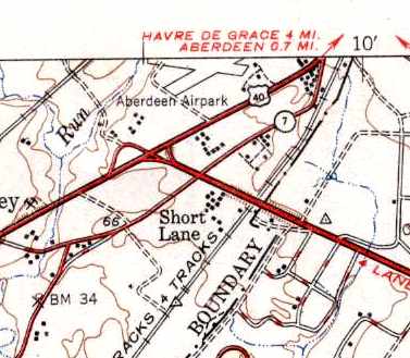
Aberdeen Airpark, Aberdeen, MD
39.5, -76.18 (Northeast of Baltimore, MD)
Aberdeen Airpark, as depicted on the 1946 USGS topo map.
According to the book "Maryland Aloft" by Preston, Lanman, and Breilhan,
Aberdeen Airpark opened in about 1946.
It was owned by Merrill Bowden,
and was said to comprise of a 100-acre property between Route 40 on the south & a railway line on the north.
It offered flight instruction, charter, fuel, and minor repairs.
Its 2 runways were 2,100' & 1,800' long.
The earliest depiction of Aberdeen Airpark which has been located was on the 1946 USGS topo map.
Aberdeen Airpark was not yet depicted on the April 1947 Washington Sectional Chart (according to Chris Kennedy).

The earliest aeronautical chart depiction of Aberdeen Airpark which has been located
was on the November 1947 Washington Sectional Chart.
It depicted Aberdeen as having a 2,400' unpaved runway.
According to a Harford County Directory (courtesy of Mike Wotovich),
“Aberdeen Airpark was started in 1947 on the site of the old Bradford Estate
and has since become the centre of aviation activity in Harford County.”
The field was said to have 2 sod runways, 2,150' & 2,000',
and to have 20 aircraft based on the field.
The owner & operator was said to be Thomas Hill,
an aeronautical engineer who also worked for Baltimore's Glenn L. Martin Aircraft Company,
and later for the Army's Aberdeen Proving Ground.
Hill & his wife lived in a home on the airport property.
The Albatross Flying Club was based at Aberdeen Airpark.
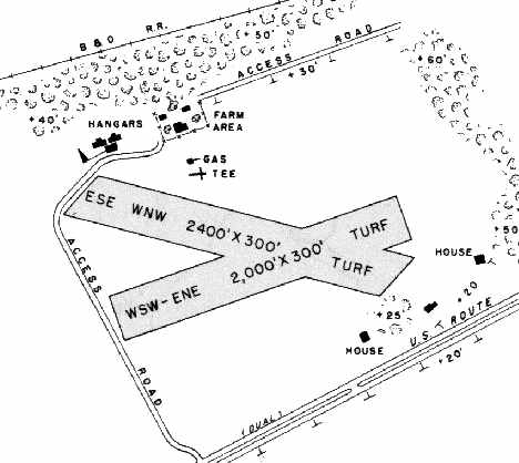
The 1950 MD Airport Directory (courtesy of Stephen Mahaley)
depicted Aberdeen Airpark as having 2 turf runways: 2,400' east-southeast/west-northwest & 2,000' west-southwest/east-northeast.
Several small hangars & buildings were depicted on the northwest side of the field.
The 1951 USGS topo map depicted Aberdeen Airpark as having 2 unpaved runways.

The earliest photo which has been located of Aberdeen Airpark was a 4/10/52 USGS aerial view.
It depicted the field as having 2 grass runways, with 6 light planes parked around several small buildings on the northwest side.
According to the book "Maryland Aloft",
a 1953 publication described Aberdeen Airpark as the center of aviation in the county,
and the headquarters of the Albatross Flying Club.

An advertisement for Aberdeen Airpark from a 1953 directory (courtesy of Mike Wotovitch).

A circa 1950s aerial view looking northeast at Aberdeen Airpark (courtesy of Mike Wotovitch)
depicted the field as having 2 grass runways.
According to Mike Wotovitch, “It was a very active field in the 1950s
and holds a special spot in my life since I flew my first solo & did much of my flying from there.
With Philips Field's hardtop runways across Route 40,
an obviously rattled Marine F4U pilot opted for this rain-soaked muddy runway.
He ran out of runway, hit the ditch, and went over on his back.”

A circa 1950s aerial view looking east at Aberdeen Airpark (courtesy of Mike Wotovitch)
showed a total of 11 single-engine aircraft parked on the field.

A circa 1950s photo by Mike Wotovitch of the barn/hangar painted “Aberdeen Airpark”.
Joe Regan recalled, “Aberdeen Airpark is the airport from which I had my very 1st airplane ride in a Piper Tri-Pacer at age 10.
Our family home was located in a small tract on the edge of the airfield.
I would walk across the corn field & hang around operations trying to find things to do.
It was actually quite a busy place around that time while owned by the Hill family. I was friends with their son, Clayton.
Finally, someone gave me a ride. Hooked! I did some private flying as I could afford it throughout my high school & college days.”
By 1960, the MD Airport Directory showed that only the shorter of Aberdeen's 2 runways remained in operation
(the west-southwest/east-northeast strip).
The March 1964 Washington Sectional Chart depicted Aberdeen as having a 2,000' unpaved runway.
The last aeronautical chart depiction which has been located of the Aberdeen Airpark
was on the March 1977 Washington Sectional Chart (courtesy of Chris Kennedy).
It depicted Aberdeen as having a 2,000' unpaved runway.
The last reference which has been located of Aberdeen being an active airfield
was its listing in the 1979 AOPA Airport Directory (according to the book "Maryland Aloft").
Aberdeen Airpark was closed at some point in 1979,
and the property was developed into housing in the same year.
By the time of the 1982 USGS topo map, the Aberdeen Airpark was no longer depicted at all.

A 5/25/13 aerial photo showed the site of the former Aberdeen Airpark completely developed with housing,
with not a trace recognizable of the former airport.
The site of Aberdeen Airpark is located at the intersection of Edmund Street & Cornwall Street.
____________________________________________________
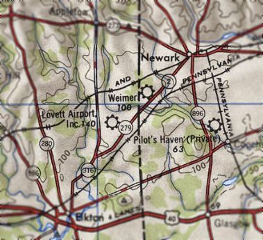
Lovett Field (2nd location) / (Original) Cecil County Airpark (2N0), Elkton, MD
39.65, -75.8 (Southwest of Wilmington, DE)
Lovett Airport, as depicted on the 1946 USGS topo map.
Lovett Field was not depicted at all (in either Delaware or Maryland)
on the 1945 Washington Sectional Chart (courtesy of John Voss)
or the 1946 Washington Sectional Chart (courtesy of Mike Keefe).
According to the book "Maryland Aloft" by Preston, Lanman, and Breilhan,
Lovett Field was reopened at some point in 1946,
at a new location just to the west across the Maryland state line
(replacing the original Lovett Field just across the state line in Delaware).
The earliest depiction which has been located of Lovett Field in Maryland was on the 1946 USGS topo map.
A 1946 MD Airport Directory described the field as having 3 hangars, an office,
and 70 aces that were usable for landing.
Waldo Lovett of Newark, Delaware, was listed as the owner & manager.

The earliest aeronautical chart depiction which has been located of Lovett Field in Maryland
was on the 1947 Washington Sectional Chart.
It described the field as having a 2,200' unpaved runway.
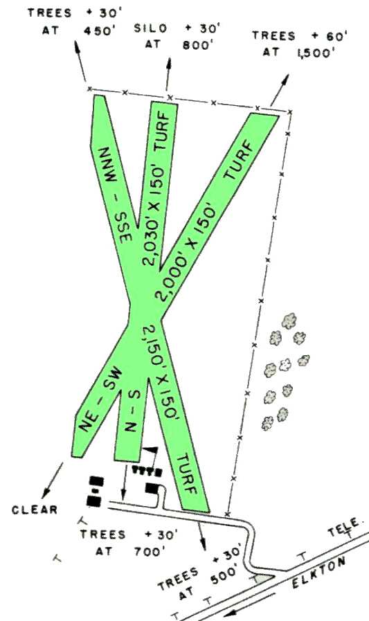
The 1950 MD Airport Directory (courtesy of Stephen Mahaley)
depicted Lovett Airport as having 3 turf runways (the longest being 2,150').
Several small hangars & buildings sat at the south end of the field.
The earliest photo which has been located of Lovett Airport was a 1952 aerial view.
It depicted Lovett as having 3 grass runways,
with several small buildings at the south end of the field.

The 1953 USGS topo map depicted Lovett Airport as having 2 unpaved runways, with several buildings on the south side.

A 1954 aerial view depicted Lovett as having 4 grass runways,
with several small buildings at the south end of the field.

A circa 1950s aerial view by Mike Wotovitch looking southwest at Lovett Airport,
showing the grass runways with several buildings at the south end.
Mike recalled, “You couldn't mistake that 'Union Jack' runway layout.”
A 1961 aerial view depicted 2 single-engine aircraft visible parked outside at Lovett Field.
“Lovett Inc.” was listed among active airports in the 1962 AOPA Airport Directory,
and described as having 3 sod runways.
The 1964 Washington Sectional Chart described the field in much the same manner.
According to the book "Maryland Aloft", Waldo Lovett operated the field until as late as 1965.
By 1966, the field had been renamed Cecil County Airpark,
and the manager was Jane Stradley.
The field was labeled "Cecil County" on the 1967 Washington Sectional Chart (courtesy of Mike Keefe).

The 1968 Flight Guide (courtesy of Robert Levittan)
depicted Cecil County Airport as having 3 turf runways (the longest being 2,150' Runway 16/34).
Several small buildings sat at the south end of the field.
A 1968 aerial view depicted 3 single-engine aircraft visible parked outside at Cecil County Airport.
The 1972 Washington Sectional Chart (courtesy of Mike Keefe)
depicted Cecil County as having a 2,100' unpaved runway.

The runway at Cecil County was evidently paved at some point between 1972-75,
as the February 1975 Philadelphia Terminal Aeronautical Chart (courtesy of Mitchell Hymowitz)
depicted Cecil County Airport as having a single 2,600' paved northwest/southeast runway.
The 1982 AOPA Airport Directory (courtesy of Ed Drury)
described Cecil County as having a single 2,600' asphalt Runway 17/35.

Diagram from 1987 Maryland State Aeronautical Chart.

The 1992 USGS aerial photo was taken shortly before the field's closure.
A total of 12 light planes were visible parked on the southwest side of the field,
and one plane was on the middle of the runway.
The 1993 Jeppesen Airport Directory depicted the Cecil County Airpark
as having a single 2,500' paved Runway 17/35,
with a ramp & three buildings on the west side of the field.

The last aeronautical chart depiction which has been located of the original Cecil County Airport
was on the March 1993 Washington Sectional Chart (courtesy of Carl Taylor).
It depicted the field as having a single 2,500' paved runway.
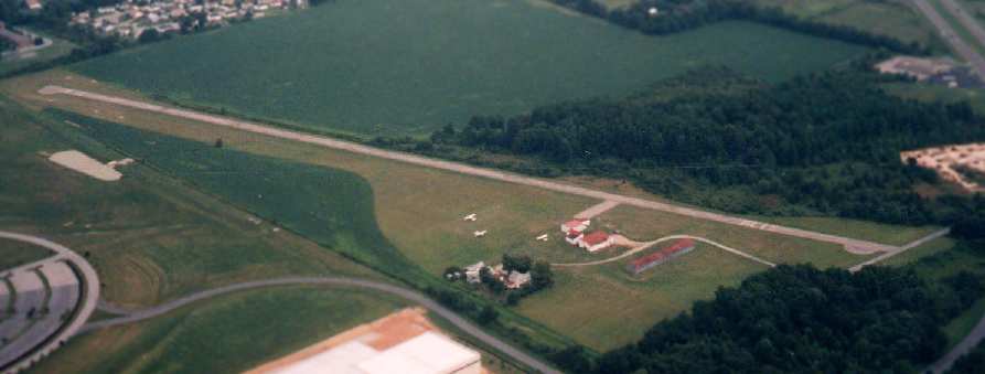
A 1997 aerial picture by Philip K. looking east at the Cecil Airport (shortly before it closed).
Note the starkly reduced number of aircraft visible on the field compared to the 1992 photo – only 3 aircraft.

The 1998 USGS topo map depicted the original Cecil County Airport as having a single paved runway.
The original Cecil County Airport was closed at some point between 1997-98,
when the increasing commercial value of the property caused the owner to sell the land to the WL Gore Company.
It was no longer depicted at all on the 1998 Washington Sectional Chart (courtesy of Mike Keefe).
According to New Garden Aviation, “The Cecil County Airport in Elkton was lost to developmental pressure & now is a Gore Products site.”
Paul Freeman flew over the site in 2000.
Only a few hundred feet of runway pavement remain at the north end of the runway.
The remainder of the pavement of the runway has been removed, along with all of the airport buildings,
and a large office complex sits over the south end of the former runway.

A circa 2006 aerial view of the remains of the original Cecil County Airpark shows the north end of the runway pavement remaining intact.

A 2013 aerial view looking southeast at the site of the original Cecil County Airpark showed a building covering the southern portion,
but the northern end of the runway remained recognizable.
The name of this airport lives on, as the former Raintree Airpark (several miles to the south)
has been renamed Cecil County Airport.
Thanks to AJ Maltenfort for providing information about Cecil County.
____________________________________________________
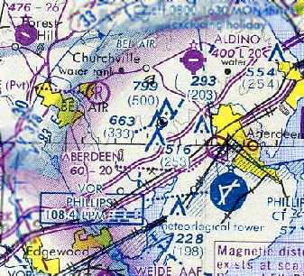
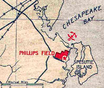
Aberdeen Proving Grounds Airfield / Original Phillips Army Airfield, Aberdeen, MD
39.47, -76.11 (Northeast of Baltimore, MD)
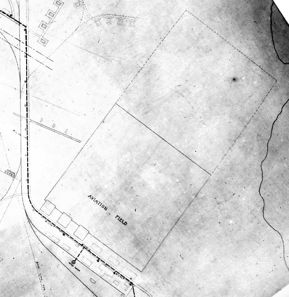
A map of the “Aviation Field” from a January 1919 completion report for Aberdeen Proving Grounds (courtesy of Ron Plante).
This former military airfield is located on the grounds of the Aberdeen Proving Ground.
According to the book "Maryland Aloft" by Preston, Lanman, and Breilhan,
shortly after the Proving Ground opened in 1917,
"an air detachment arrived & set up a base for airplanes & dirigibles
at a location described as 'behind the automotive test course.'
A report dated March 1919 stated that by the previous midsummer a landing field, shops, and hangars
worth more than a million dollars had been built halfway between headquarters & the water range,
and a bombing field had been chosen near the Bush River."
The earliest depiction which has been located of the Aberdeen Proving Ground Airfield
was a map from a January 1919 completion report for Aberdeen Proving Grounds (courtesy of Ron Plante),
which depicted the “Aviation Field” as a rectangular area with 3 buildings along the southwest side.
The airfield at Aberdeen Proving Ground was built to operate aircraft that supported the creation of bombing tables;
the techniques these tables provided were a means of improving the adequacy of aerial bombing.

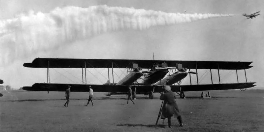
An undated photo of a Handley Page biplane bomber carrying a massive 4,000 pound bomb.
In September 1921, a Handley Page bomber at Aberdeen Proving Ground dropped a 4,000 pound bomb - then a world record.
According to the Harford County Directory (courtesy of Mike Wotovitch),
“In 1922 a giant Army C-2 dirigible arrived here for testing aerial bombs.”
On 6/5/23, another Handley Page bomber crashed on takeoff at the proving ground.
Pilot Lt. Wendell Phillips perished, but his actions were credited with saving the lives of 5 others onboard the plane.
The airfield was shortly renamed in his honor.

An undated photo of a JN-4 Jenny biplane at Phillips AAF.
An aeronautical bulletin issued by the Army in 1923 described the airfield
as an irregularly-shaped are offering a landing distance of 2,000'.
The 1923 “Camp Site Guide Including All Airplane Landings in the U.S.A.” by the U.S. Touring Information Bureau (courtesy of Jonathan Westerling)
described Aberdeen as a government airfield, measuring 2,000' northwest/southeast by 2,000' northeast/southwest.
It was said to have “several hangars, marked”.

A 10/30/23 photo of an Army Martin biplane bomber (model undetermined) equipped to lay smokescreens at Phillips Field (from the National Archives, courtesy of Ron Plante),
with 2 hangars in the background.
A 10/30/23 photo of the sole example of the Lowe-Willard-Fowler tri-motor night bomber named "The Owl" at Phillips Field (from the National Archives, courtesy of Ron Plante),
with an Army Martin biplane bomber laying a smokescreen above it.

A 1926 photo of a massive 4,000 pound bomb at Aberdeen Proving Ground.

The 1929 "Rand McNally Standard Map of MD with Air Trails" (courtesy of Chris Kennedy)
described Philips Field as being 2,000' x 2,000' in size.

The May 1932 J-18 Washington D. C. Airway Map (courtesy of Chris Kennedy)
depicted the original Phillips Field. along with the nearby Site 62A & 62B Airway Beacons.
Interestingly, the chart also depicted a "hangar" to the southwest of the original Phillips Field,
in the location eventually occupied by the replacement Phillips Field.

A 1932 map shows the hangars & other structures south of the Phillips “Aviation Field” (from NARA Philadelphia, courtesy of Ron Plante).
Phillips Field, as depicted on the 1934 U.S. Navy Aviation Chart (courtesy of Chris Kennedy).
The 1934 Department of Commerce Airport Directory (according to Chris Kennedy)
described "Phillips Field, Army" as having an "L" shaped, 2,500' x 1,500' sod landing area.
It also said, "Field under construction, lights disabled.
Pilots are cautioned to exercise extreme care in landing during daylight hours, unsafe for night operations."

The original Phillips AAF, as depicted on the 1935 Washington Sectional Chart.
Interestingly, the chart also depicted a "hangar" to the southwest of the original Phillips Field,
in the location eventually occupied by the replacement Phillips Field.
The January 1, 1936 Department of Commerce Airway Bulletin
described Phillips Field as consisting of am irregularly-shaped sod field,
with 3 paved runways: 3,000' northeast/southwest & northwest/southeast, and 2,400' north/south.
A hangar & other buildings were said to be located on the south side of the field.

Aerial view looking north at the original Phillips AAF,
from the Airport Directory Company's 1937 Airports Directory (courtesy of Bob Rambo).
The directory described Phillips Field as having 3 hard-surfaced runways, with the longest being 3,000'.
The aerial photo in the directory depicted a single hangar with a checkerboard pattern on the roof,
southwest of the runways.
According to the book "Maryland Aloft",
"It has been reported that the technique of dive-bombing was first tried at Aberdeen Proving Ground,
and that a 75mm aircraft cannon was test first here during a B-18 flight in 1939."
Phillips AAF was depicted on the 1940 & 1942 Washington Sectional Charts (courtesy of Mike Keefe),
along with the notation, "Civilian emergency use only."
According to the Harford County Directory (courtesy of Mike Wotovitch),
“The old airfield was abandoned early in 1943
and all the Air Corps activities were moved to the present airport location.”
The original Phillips Field was replaced by a larger airfield to the west (the present-day Phillips AAF),
as the original airfield was not large enough to operate modern bombers.

The original Phillips Field was depicted as "Abandoned Airport" on the 1944 USGS topo map.
By the time of the 1944 Washington Sectional Chart (courtesy of Mike Keefe),
the old airfield was no longer depicted at all on the chart.

The "Abandoned Airport" was still depicted on the 1991 USGS topo map,
with 3 paved runways (the longest being 4,400').
An auto test course had been constructed adjacent to the north side of the field.

A 1995 USGS aerial view looking north showed the original Phillips Field's 3 former runways were still recognizable,
as well as the hangar which remains standing at the south side of the field.

A circa 2006 aerial view looking south at the 1930s-era hangar which remains standing at the site of Philips Field.
Note the attached airfield operations office.

A 2013 aerial view looking north showed the original Phillips Field's 3 former runways were still recognizable.
____________________________________________________
Since this site was first put on the web in 1999, its popularity has grown tremendously.
That has caused it to often exceed bandwidth limitations
set by the company which I pay to host it on the web.
If the total quantity of material on this site is to continue to grow,
it will require ever-increasing funding to pay its expenses.
Therefore, I request financial contributions from site visitors,
to help defray the increasing costs of the site
and ensure that it continues to be available & to grow.
What would you pay for a good aviation magazine, or a good aviation book?
Please consider a donation of an equivalent amount, at the least.
This site is not supported by commercial advertising –
it is purely supported by donations.
If you enjoy the site, and would like to make a financial contribution,
you
may use a credit card via
![]() ,
using one of 2 methods:
,
using one of 2 methods:
To make a one-time donation of an amount of your choice:
Or you can sign up for a $10 monthly subscription to help support the site on an ongoing basis:
Or if you prefer to contact me directly concerning a contribution (for a mailing address to send a check),
please contact me at: paulandterryfreeman@gmail.com
If you enjoy this web site, please support it with a financial contribution.
please contact me at: paulandterryfreeman@gmail.com
If you enjoy this web site, please support it with a financial contribution.
____________________________________________________
This site covers airfields in all 50 states.
For the site's main menu: Home