Abandoned & Little-Known Airfields:
Northern Maine
© 2002, © 2016 by Paul Freeman. Revised 11/26/16.
This site covers airfields in all 50 states: Click here for the site's main menu.
____________________________________________________
Please consider a financial contribution to support the continued growth & operation of this site.
Estcourt Station Airport (revised 7/15/16) - Milford Air Force Auxiliary Airfield (revised 4/27/12) - Red Pine Grove Airfield (revised 11/26/16)
____________________________________________________________________________
Estcourt Station Airport, Estcourt Station, ME
47.44, -69.15 (North of Bangor, ME)
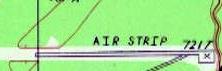
The Estcourt Station runway was depicted as “Air strip” on the 1987 USGS topo map.
Photo of the airfield while in use has not been located.
Not much is known about this airfield, including its name, purpose, or date of construction.
It has the distinction of being the northern-most airport in Maine,
being located a mere 900' from the Canadian Border.
The Estcourt Station Airport was evidently established at some point between 1956-87,
as it was not yet depicted on the 1956 USGS topo map.
The February 1969 Aroostook Sectional Chart only depicted a seaplane base at Estcourt, but not airport.
The earliest depiction which has been located of Estcourt Airport was on the 1987 USGS topo map,
which depicted a single paved east/west 2,600' paved runway, with a small paved ramp on the southeast side,
with an additional unpaved 1,800' overrun on the west side.
The field was labeled simply as “Air Strip”.
A clue as to the purpose of the Estcourt Airport came from Dean Wilber, who reported:
“The airstrip at Estcourt Station looks identical to the one located off the Ragmuff Road near Chesuncook Lake, beyond the middle of nowhere.
They both have the small shed & a big tank. My grandparents lived near the one on Ragmuff.
They told me that the airstrip was built in the 1980s when there was a huge outbreak of Spruce Budworm in Maine.
The airstrip was where planes were loaded with pesticides to spray (crop dust) the forests & kill the budworms.”
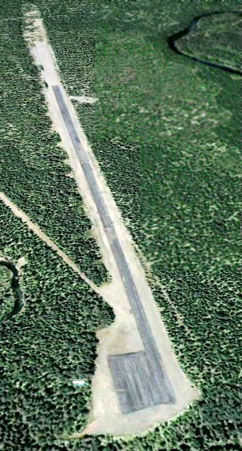
The earliest photo which has been located of the Estcourt Station Airport was a 6/24/06 aerial view.
It depicted the field as having single paved east/west paved runway, with a small paved ramp on the southeast side,
with an unpaved overrun on the west side.
There did not appear to be any buildings at the airfield.
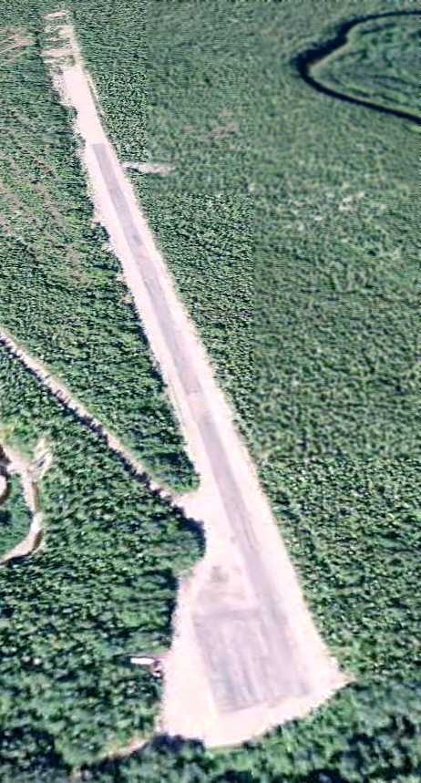
A 9/1/11 aerial view looking west showed the Estcourt Station Airport to remain unchanged compared to the 2006 photo.
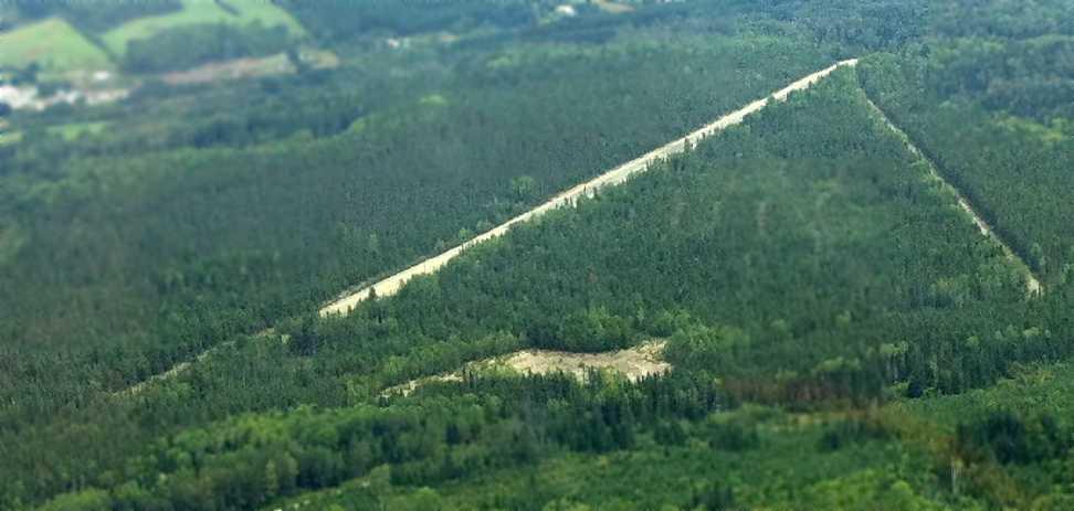
An August 2012 aerial view looking northeast at Estcourt Station Airport by Ron Denning (courtesy of Mike Denning).
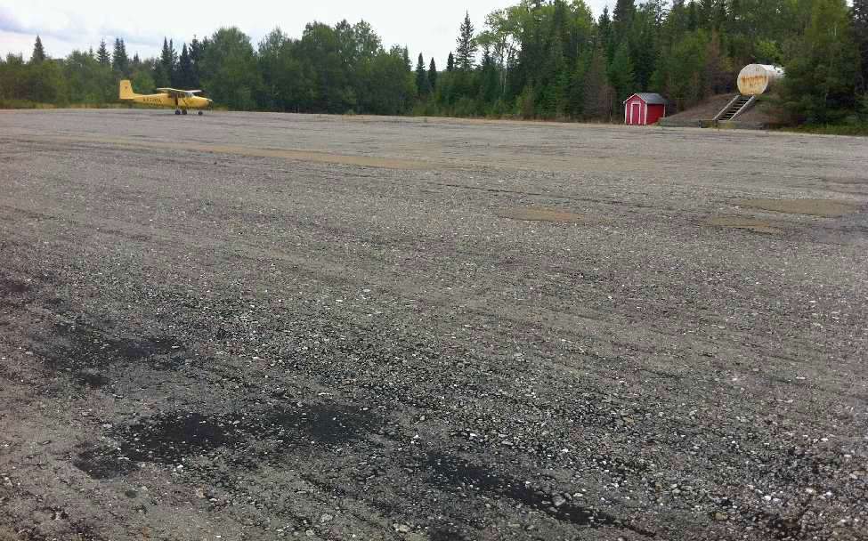
An August 2012 photo by Ron Denning (courtesy of Mike Denning) of their 1956 Cessna 172, showing a water tank & small shed next to the Estcourt Station runway.
An August 2012 photo by Ron Denning (courtesy of Mike Denning) looking along the Estcourt Station runway.
Mike reported, “The runway surface is asphalt that seems to have been made on site with the local gravel. The rocks in the asphalt are fairly large.
The condition is in the lower-fair range, there are some bad spots at about the half-way point.
Overall the whole paved area of the runway & parking area has a soft feeling under foot.
When the Border/Customs agency was contacted in Estcourt prior to the trip the agent we spoke with said that the runway is still used occasionally, by who he did not know.
From the end of the paved runway westbound it is approximately 4 miles to the Canadian border.
From the paved end of the runway eastbound the border is approximately 0.25 miles.
We approached from the southwest & landed eastbound keeping well away from the river that depicts the border.
Takeoff was westbound with an immediate left turn that also kept us away from the border.”
Estcourt Station Airport is located at the eastern terminus of Airport Road, appropriately enough.
Thanks to Patrick Therrien for pointing out this airfield.
__________________________________________________________________________
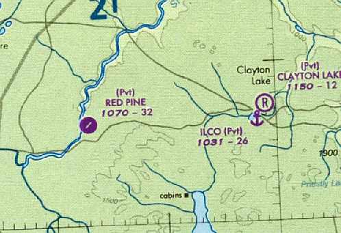
Red Pine Grove Airfield (ME21), Dickey, ME
46.597, -69.79 (North of Bangor, ME)
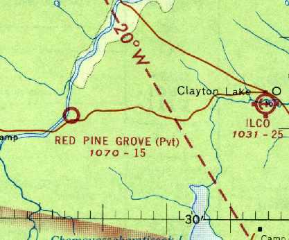
Red Pine Grove Airfield, as depicted on the April 1966 Aroostook Sectional Chart (courtesy of David Brooks).
Photo of the airfield while in use has not been located.
This airfield is located only 11 miles from the Canadian border,
in the extremely remote northwest corner of Maine.
The Red Pine Grove Airfield was evidently constructed at some point between 1965-66,
as it was not yet depicted on a 5/1/60 aerial photo nor on the 1965 Aroostook Sectional Chart (according to David Brooks).
The earliest depiction of this field which has been located
was on the April 1966 Aroostook Sectional Chart (courtesy of David Brooks).
It depicted “Red Pine Grove” as a private airfield with a 1,500' unpaved runway.
According to Charles Beam, “Red Pine was originally built by a large paper company.
It was a wonderful place to take a spouse or girlfriend for a picnic & some fishing.”
The 1966 AOPA Airport Directory (according to David Brooks)
described Red Pine Grove as having a single 1,500' packed gravel Runway 9/27.
It was said to be unattended, private, and closed to the public.
The 1970 AOPA Airport Directory (according to David Brooks)
described the field in the same manner, but added that it was for emergency use only.
Jonathan Ludlow reported, “This year I again made my annual pilgrimage to the North Maine Woods.
The driver for the outfitter who drove us in was a veteran Maine aviator.
When asked about Red Pine this gent stated firmly that it had been built to support the campaign against the spruce budworm during the 1970s.
According to my informant the field was the base to a flight of converted TBM Avengers.”
According to Jeremy Williams, “I can offer this about Red Pine Grove:
I remember the field was paved sometime in the 1970s
as a result of the spruce bud worm epidemic & used as a base for aerial application.
There are stories of TBM’s & other WW2 aircraft going down in the North Maine Woods not only during WW2,
but as a result of old aircraft being used in the spraying project.”
Joseph Shovlin reported in 2007, “I was up at a commercial campground on Ross Lake.
One of the employees of the site told me that Red Pines was expanded some 30 years ago for DC-3s
which were being used to spray the forest for some sort of wood disease.
He said it hadn't been used since that time,
and that the locals would bring their various & sundry autos out & see if they can get them up to 60 MPH on the asphalt.”
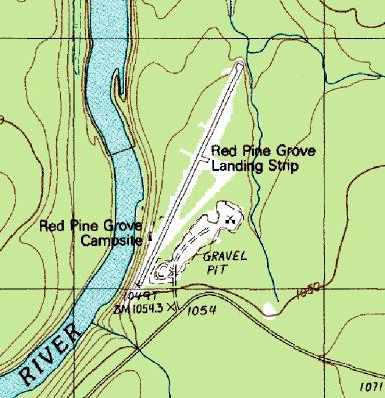
Red Pine Grove apparently gained a paved runway (with a different orientation) at some point between 1970-86,
as the 1986 USGS topo map depicted the “Red Pine Grove Landing Strip”
as having a single 3,000' paved runway.
There did not appear to be any buildings associated with the airfield,
although the “Red Pine Grove Campsite” had one small building depicted on the west side of the runway.
According to an accident report (courtesy of Joseph Shovlin), on 5/28/90 a Piper PA-22 was on final approach to Red Pine
“at 20' AGL & about midfield of a 3,200' runway, when a go around was attempted.
He determined that he would not be able to clear the trees, and elected to land at the end of the runway and roll into the trees.”
The airfield was labeled simply as “Landing Strip” on the 1993 USGS topo map.
As of a 1998 tax document (courtesy of David Brooks),
the “Red Pine Grove Landing Area” was listed with an airfield code of ME21.
The last chart depiction which has been located of Red Pine as an active airfield
was on the 2004 Montreal Sectional Chart (courtesy of David Brooks).
It depicted “Red Pine” as a private airfield having a single 3,200' paved runway.
Jonathan Ludlow reported that the Red Pine airfield “is nicely depicted on Microsoft Flight Simulator 2004 - A Century of Flight Edition.”
The Red Pine airfield apparently was abandoned (for reasons unknown) at some point between 2004-05,
as it was no longer depicted on the 2005 Sectional Chart,
or listed among active airfields in the FAA Airport/Facility Directory.
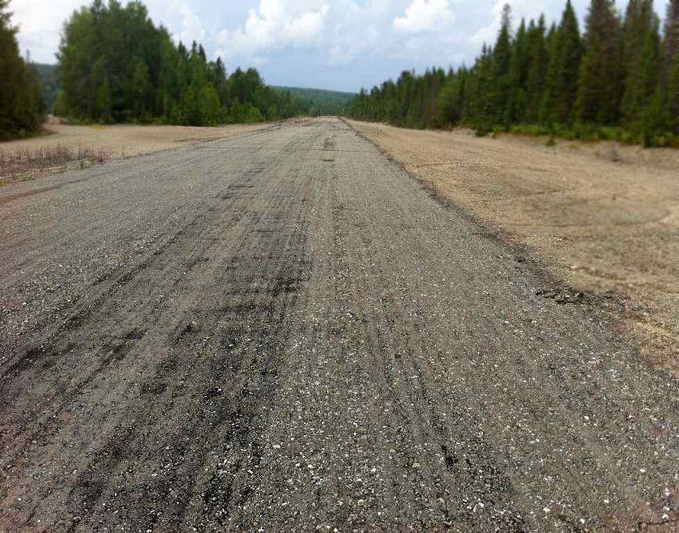
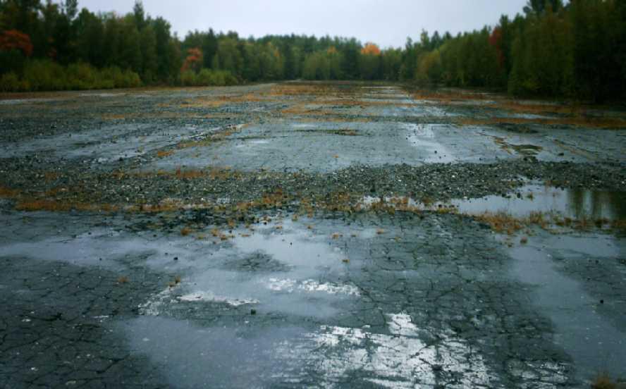
A 2005 photo by Jonathan Ludlow,
showing the fairly decent condition of the Red Pine Grove runway pavement.
Jonathan Ludlow reported in 2005, “I have just completed a canoe trip down the St John River in Maine.
On the trip I encountered an apparently abandoned strip.
The location was about one mile down river from Moody Bridge on the river right in T11R16.
From the location you will note that this is in Maine's 'unorganized' townships about 80 miles from the nearest paved road.
The nearest inhabited location is Daaqam in Quebec Province.
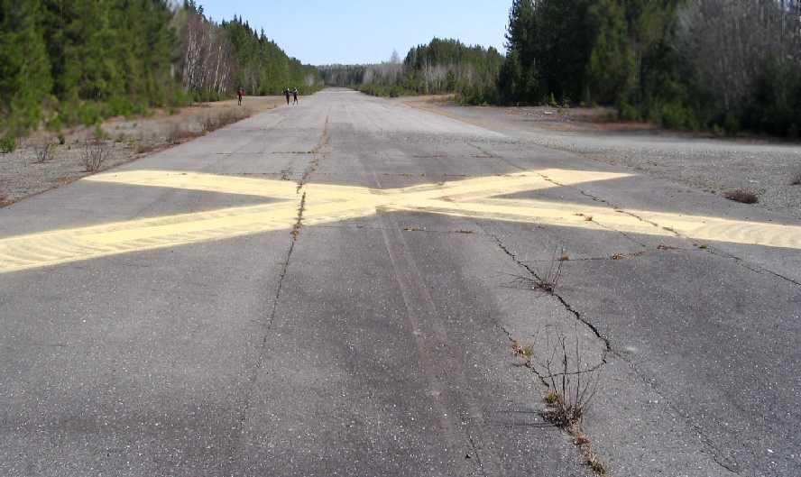
The strip is described somewhere as 2,100'. It looks longer. The main runway is north-northeast.
The runway is X'ed [marked with closed-runway symbols] at both ends & in the middle.
It is in pretty good condition (blacktop) with only a few frost cracks.
The other arm of the V is aligned northeast is mostly dirt with some evidence of very old blacktop.
There is a dirt track to the logging company road at the southwest end of the V.
There are several North Maine Woods camping places on the West side of the main runway.
These are designated fireplace sites consisting of a fire ring & a picnic table, and a lovely North Maine Woods outhouse.
As to activity there were several tire marks at the southwest end. I did not inspect the northeast end.
On the whole the setup looked perfect for fly-in hunters, fishermen or canoe trippers.
I very much doubt however if the strip which must cost many $$$ to build was installed for their benefit.
It looks too substantial for logging operation support -
the logging companies are very good at building stuff that is (only just) good enough - look at their bridges!”
Jeremy Williams reported in 2006, “I have landed at Red Pine many times & find the field still quite usable.”
Charles Beam reported in 2006, “ Several years ago the land was transfered to an environmental outfit.
I believe they decided to ban noisy aircraft from their land.
Initially they placed boulders at each end.
I think the lawyers, fearing a lawsuit should an airplane make an emergency landing,
had the rocks removed, and put a white X at each end & in the middle.
I flew by there in August & the X's are now yellow.
The asphalt looked to be in good shape.”
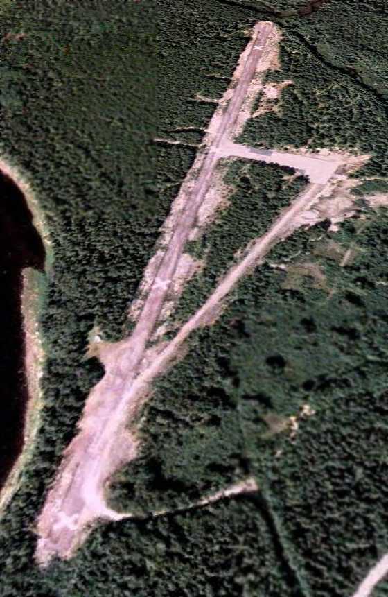
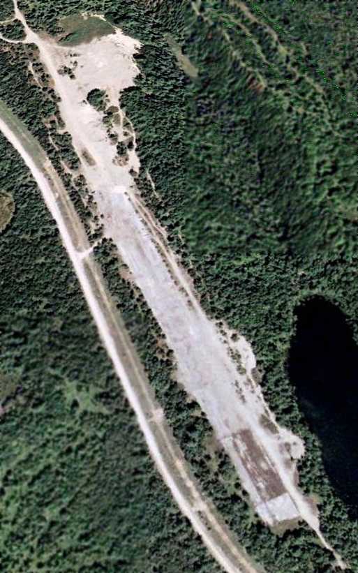
A 9/30/07 aerial view looking north depicted the Red Pine Grove runway,
with closed-runway “X” symbols visible at each end.
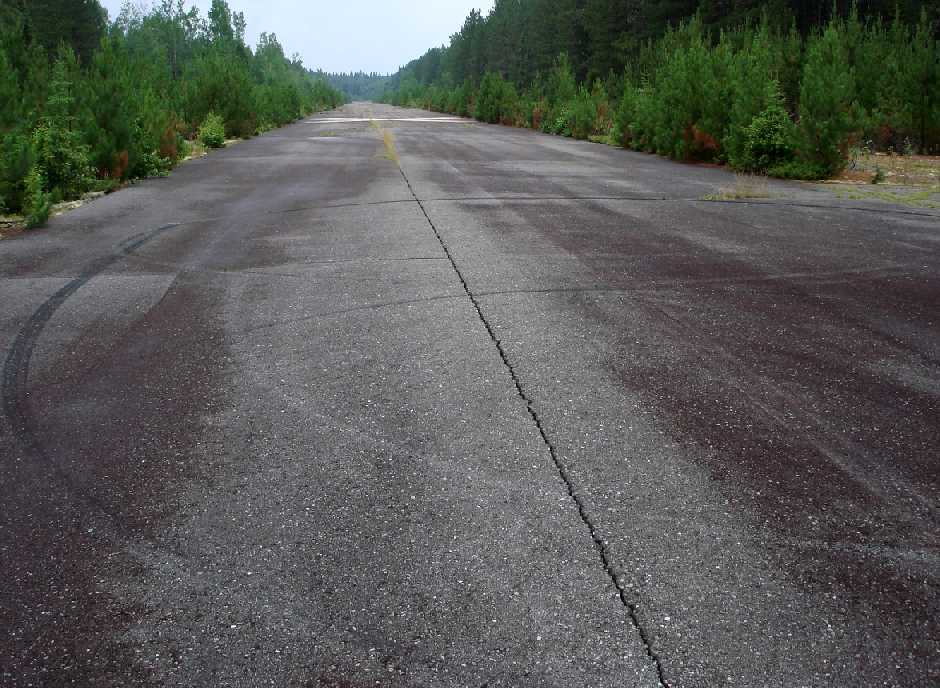
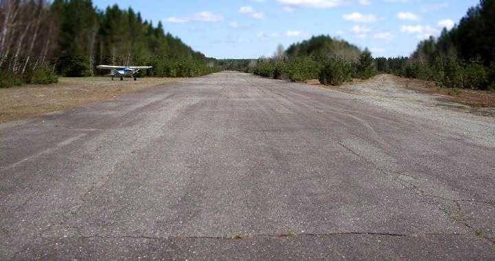
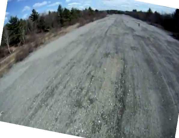
A July 2010 photo by Peter Fernald showing the fairly decent condition of the Red Pine Grove runway pavement.
Peter reported, “The actual runway was in good shape.
The campsites are very well kept & the St. John River is a nice place to fish at certain levels.
I have only flown a little as a pilot but the runway was better then some I have landed on.”
A 2011 photo by Mike Smallidge of his PA22/20 at Red Pine Grove.

A 2013 aerial view looking northwest depicted the Red Pine Grove runway as remaining intact, painted with closed-runway “X” symbols.
__________________________________________________________________________
Milford Air Force Auxiliary Airfield, Milford, ME
44.98 North / 68.47 West (Northeast of Bangor, ME)
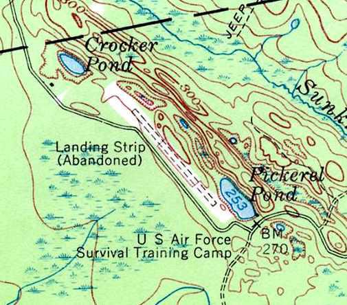
“Landing Strip (Abandoned)”, as depicted on the 1957 USGS topo map (courtesy of Gary Small).
According to Pete Noddin of the Maine Aviation Historical Society,
“This strip & the adjacent buildings on Pickerel Pond were constructed in 1942
as the administrative support area for the Bangor (Dow AAF) Precision Bombing Range
which was located in an open bog just south of the airstrip.”
Gus LeBlanc recalled, “My uncle John was stationed at Dow AFB (now Bangor International) as a SAC commander.
I was also told by my uncle John that the field was used during WW2 to train medium bomber pilots on short field landings & take offs.
He also indicated that the site was used briefly towards the end of the war
to temporarily house some German POWs due to the camp in Aroostook County being full.”
No airfield at all was depicted at this location on aeronautical charts
from 1942, 1944, 1945, or 1954 (according to Chris Kennedy).
According to Pete Noddin, “After WW II, when Dow AAF was reactivated by the 14th Fighter Group,
the bombing range did not meet current safety clearance requirements.
It operated under a waiver & was used by F-47N & F-84B aircraft as a bombing/strafing range until 1948.
At that time a new range was opened near Deblois Maine.
The bombing range portion of the property was sold as surplus in 1952.
When SAC began occupying Dow AFB in 1953, with the 506th Strategic Fighter Wing,
the buildings, pond and strip were used as an aircrew survival training facility.
This use appears to have ended sometime in the 1957-58 era.”
The earliest depiction of this field which has been located
was on the 1957 USGS topo map.
It depicted a single 2,500' runway, oriented northwest/southeast,
labeled “Landing Strip (Abandoned)”.
The property was also labeled “U.S. Air Force Survival Training Camp”.
Gus LeBlanc recalled, “The Pickerel Pond airstrip... I grew up in Old Town
and in the 1960s & 1970s spent a lot of time at the airstrip & surrounding area.
At that time the remnants of the Air Force survival school still existed on the site.
There was a building which housed school personnel
and there was a 'slide for life' structure with a cable which led to the pod & had a trolley slide on it.
My uncle John was stationed at Dow AFB (now Bangor International) as a SAC commander.
He took me out to the facility on several occasions.
The original bombing range in the bog south of the field...
When I spent time out there in the 1960s & 1970s the remains of the range still existed.
In the middle of the bog was a large pyramid structure (bombing target) mad of wood.
Unknown to many there was also a spotting tower in the tree line west of the bog.”
Gary Small recalled of this airfield, “I discovered it while going to the University of Maine in nearby Orono about 1974 or 75.
I was exploring the network of logging roads in the area east of Old Town,
and burst out of the woods onto this old airstrip.
It is literally in the middle of the woods, miles from the nearest town.
As I remember, the strip was either paved or concrete,
although it was broken up & weeds small trees were coming up.
I was told that it was an auxiliary or emergency field for Dow Air Force Base in nearby Bangor.
At the time, the National Guard was using it as a training area.”
This field was depicted as an abandoned airfield on the October 1976 Halifax Sectional Chart (courtesy of Chris Kennedy).
On the 1988 USGS topo map, the runway was no longer depicted at all
(even though the clearing around the former runway was still depicted),
and the site was no longer labeled as having any military connection.
Gus LeBlanc recalled, “The spotting tower in the tree line west of the bog... I visited the area about 1991 & the tower was still there.”
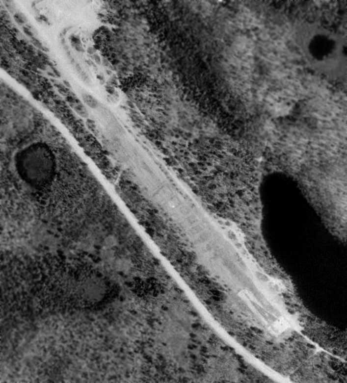
As seen in the 1997 USGS aerial photo,
the abandoned runway is still quite recognizable, although somewhat deteriorated.
Bill Robichaud visited the site of the Milford airfield in 2006.
He reported, “Its condition seems to be unchanged.
There were many 'No Trespassing' signs along the roadside,
which the airfield runs parallel to, so I did not enter the site.
However I was able to see down its length, the pavement seems to be quite broken up,
but not unrecognizable as an airstrip.
There was a truck parked on the southern end of the strip,
though the Maine Youth Fish & Game camp gate was open (located on the other side of Pickerel Pond),
so it may have been one of their vehicles.”
A 7/25/07 aerial view looking north depicted the remains of the Milford runway.
A 2008 photo by David Dauphinee looking along the abandoned runway at Milford.
David reported, “It is largely unchanged from the update from 2006.
The pavement is broken up & missing in some places with weeds growing through. In many places, paint is still evident.
It was easily accessed by taking Studmill Road east from Route 2 in the Milford/Greenbush area.
I drove straight through the open gate for the youth conservation camp on Pickerel Pond & then walked up a small hill to my left.
Visitors should use caution as the site is clearly used by several hunters for target practice (shell casings everywhere).”
Gus LeBlanc reported in 2008, “The remnants of the Air Force survival school... are now used by the Maine Youth Fish & Game Association.”
A still from a 4/26/12 video by Brian Barainca taken from his radio-controlled model aircraft, on short final to the runway at Milford.
Brian is visible on the top-right on the runway.
The site of the Milford airfield is located southeast of the intersection of County Road & St. Regis Road,
9 miles east of Milford, ME.
____________________________________________________
Since this site was first put on the web in 1999, its popularity has grown tremendously.
That has caused it to often exceed bandwidth limitations
set by the company which I pay to host it on the web.
If the total quantity of material on this site is to continue to grow,
it will require ever-increasing funding to pay its expenses.
Therefore, I request financial contributions from site visitors,
to help defray the increasing costs of the site
and ensure that it continues to be available & to grow.
What would you pay for a good aviation magazine, or a good aviation book?
Please consider a donation of an equivalent amount, at the least.
This site is not supported by commercial advertising –
it is purely supported by donations.
If you enjoy the site, and would like to make a financial contribution,
you
may use a credit card via
![]() ,
using one of 2 methods:
,
using one of 2 methods:
To make a one-time donation of an amount of your choice:
Or you can sign up for a $10 monthly subscription to help support the site on an ongoing basis:
Or if you prefer to contact me directly concerning a contribution (for a mailing address to send a check),
please contact me at: paulandterryfreeman@gmail.com
If you enjoy this web site, please support it with a financial contribution.
please contact me at: paulandterryfreeman@gmail.com
If you enjoy this web site, please support it with a financial contribution.
____________________________________________________
This site covers airfields in all 50 states.
For the site's main menu: Home