Abandoned & Little-Known Airfields:
Northern Michigan
© 2002, © 2016 by Paul Freeman. Revised 11/3/16.
This site covers airfields in all 50 states: Click here for the site's main menu.
____________________________________________________
Please consider a financial contribution to support the continued growth & operation of this site.
Acme Skyport (added 4/5/16) - Au Gres Airport (revised 9/17/16) - Mason Landing Field / Kelleys Airport (added 5/13/15) - Marquette County Airport (revised 9/21/14)
Raco Landing Field / Raco AAF (revised 2/24/16) - Rexton Airport / D A R Airport (revised 12/24/15) - Standish City Airport / Standish Industrial Airport (revised 11/3/16)
Vanderbilt Airport (1st location) (revised 11/20/14) - Vanderbilt Airfield (2nd location) (revised 11/9/14)
____________________________________________________
44.766, -85.471 (Northwest of Detroit, MI)
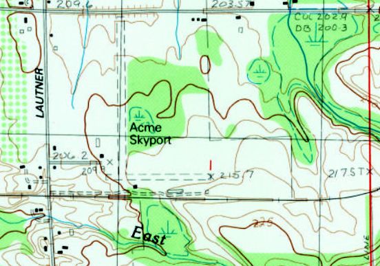
Acme Skyport, as depicted on the 1983 USGS topo map.
According to the Yorkburg Manor website (courtesy of Marc Boudreau), “Willard & Isabelle Ritter... In 1969 they developed an airport on the back of the farm that was known as the Acme Skyport.”
The earliest depiction which has been located of Acme Skyport was on the 1983 USGS topo map.
It depicted Acme Skyport as having 2 perpendicular unpaved runways,
with a few small buildings on the southwest & south sides.
Marc Boudreau recalled, “Acme Skyport... I used to take my students over there from nearby TVC for soft field practice.
There is a shorter private East/West runway that, oddly enough, was not technically connected to the North/South runway.
Called Gramp's Acres or something similar on the charts, it was not part of the public-use portion.
There was only one owner, but I just always assumed he preferred the public not use the rather short East/West runway.
There was a difference in elevation between the south end of the North/South runway & the East/West one, which was a little lower. Uneven terrain between them, as well.

The 1989 USGS topo map depicted “Acme” Airport as having 2 perpendicular runways.
The March 1990 Airport/Facility Directory (courtesy of Marc Boudreau) described Acme Skyport as having 2 runways: 18/36 & 9/27.
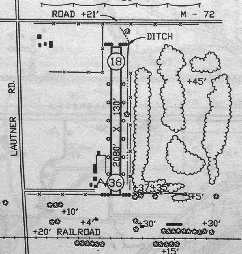
The 1992 MI Airport Directory (courtesy of Marc Boudreau) depicted Acme Skyport as having only a single 2,080' Runway 18/36,
and cautioned that the E/W runway was closed.
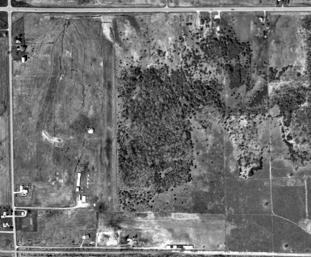
The only photo which has been located showing aircraft at Acme Skyport was a 1993 USGS aerial view.
It depicted Acme Skyport as having 2 perpendicular unpaved runways,
with 4 light single-engine aircraft visible parked to the southwest of the Runway 18/36.

The only aeronautical chart depiction which has been located of Acme Skyport was on the 1993 MI Aeronautical Chart (courtesy of Marc Boudreau).
It depicted Acme as having a 2,100' unpaved runway.
Acme Skyport was evidently closed (for reasons unknown) at some point between 1993-97,
as it was no longer depicted on the 1997 Michigan Aeronautical Chart (according to Marc Boudreau).
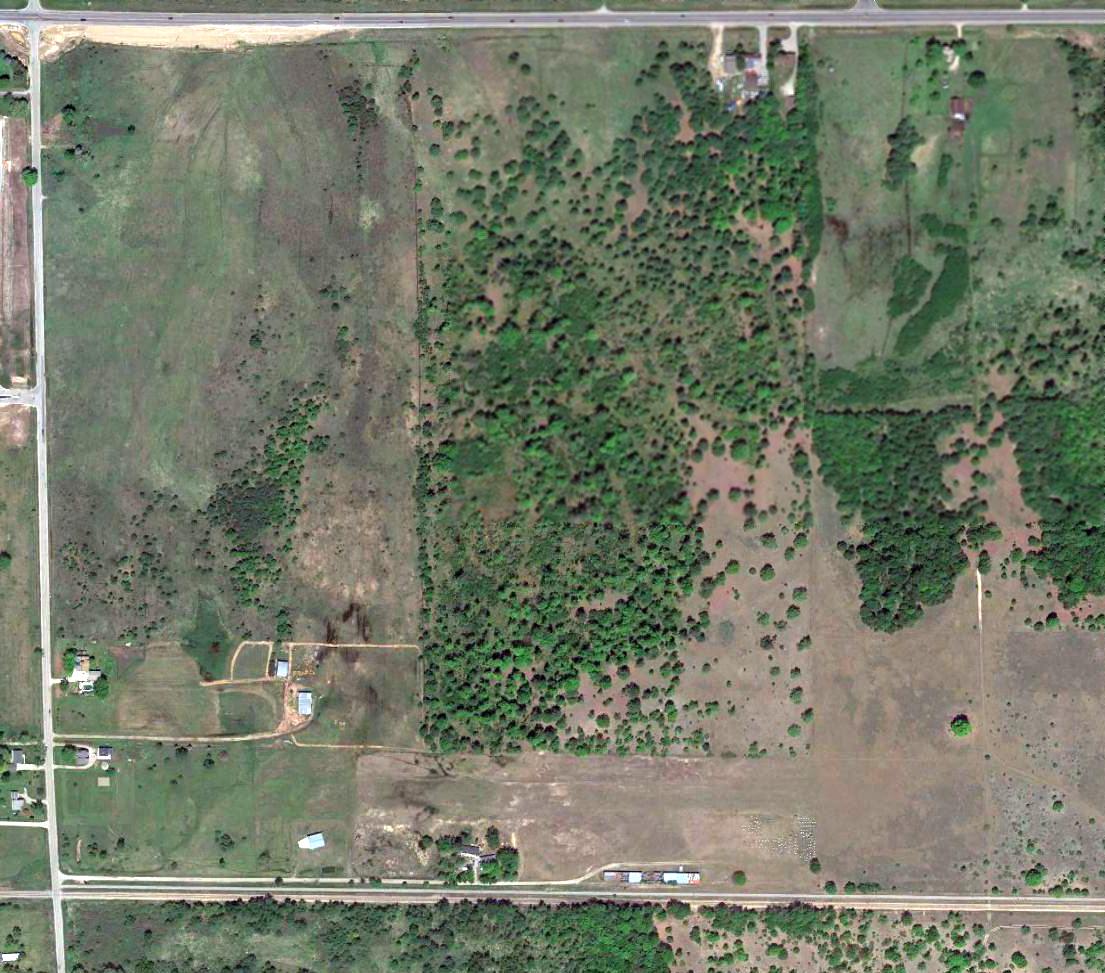
A 2015 aerial view showed Acme Skyport to remain intact, though devoid of aircraft.
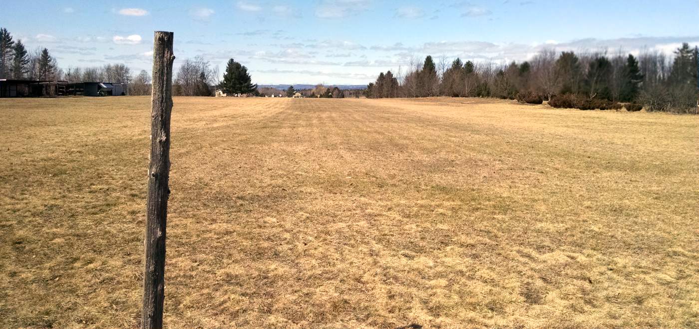
A 3/20/16 photo by Marc Boudreau at Acme Skyport, “Looking west on Runway 27. The far end is not visible due to the sloping terrain.
It looks like it might possibly still be maintained for someone's private use.
The main North/South runway is no longer usable.”
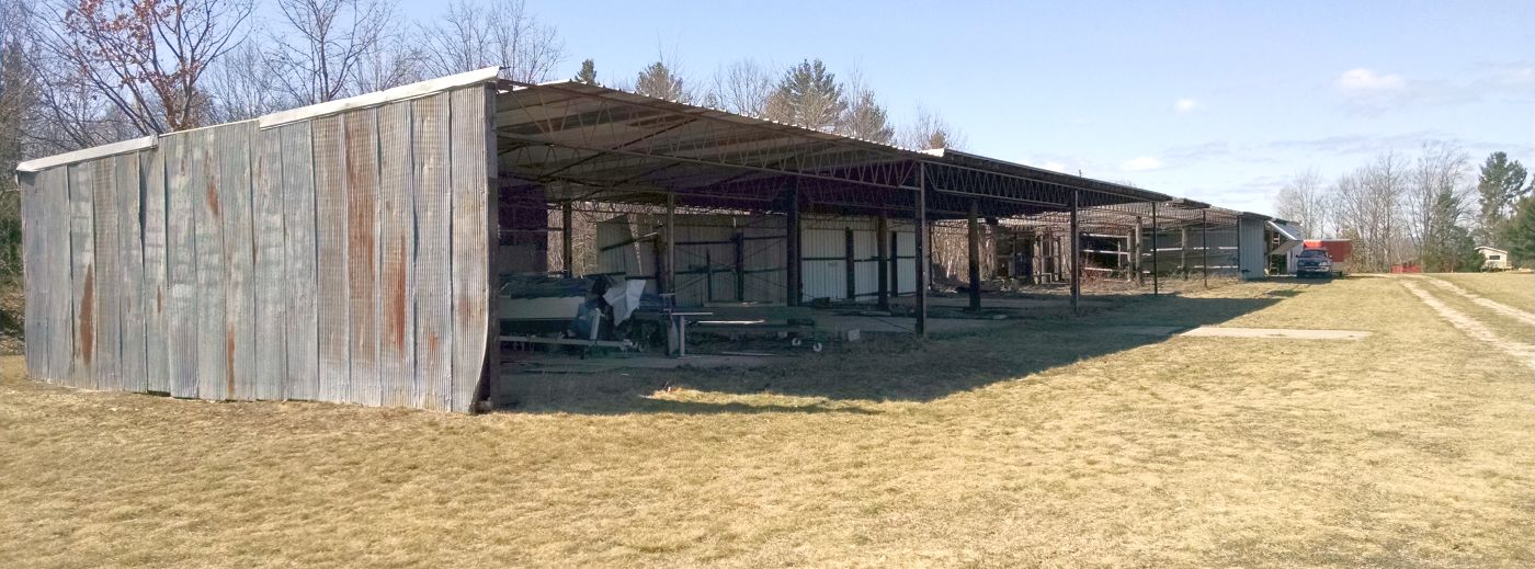
A 3/20/16 photo by Marc Boudreau at Acme Skyport, “of dilapidated hangers on the southeast side of the airport.”
No aircraft are visible, and a boat is stored in one hangar.
Mark reported, “A couple old hangers remain northwest of the 'intersection' & one 'newer' hanger south of the intersection with a concrete apron,
although I remember 2 former metal T-hangar type buildings for maybe 5-6 airplanes each.
One was located Northwest of the 'intersection', and another fairly dilapidated one south, both parallel to their respective runways.”
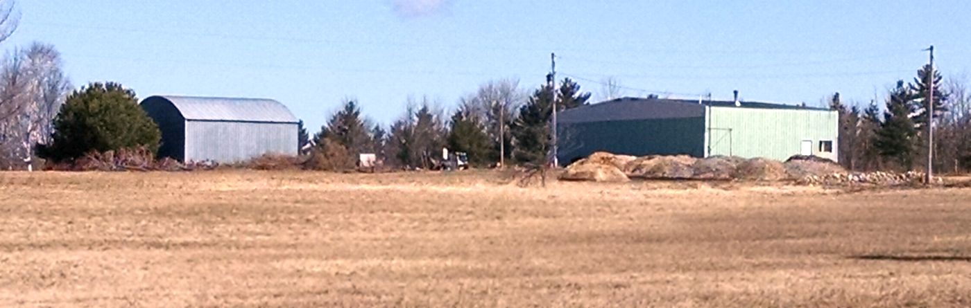
A 3/20/16 photo by Marc Boudreau at Acme Skyport, “Looking northeast from the threshold of Runway 9 towards the 2 hangars to the northwest of the runway intersection.
The hangars shown to the north of these 2 separate hangers on the 1992 Michigan Airport Directory are no longer extant.”
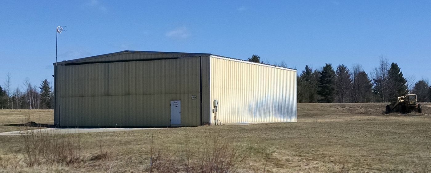
A 3/20/16 photo by Marc Boudreau at Acme Skyport, “of the hangar on the southwest side, with windsock frame.”
As of 2016, Acme Skyport was no longer depicted on aeronautical charts.
The site of Acme Skyport is located southeast of the intersection of Lautner Road & Route 72.
Thanks to Marc Boudreau for pointing out this airfield.
____________________________________________________
Mason Landing Field / Kelleys Airport (0MI3), Grayling, MI
44.63, -84.48 (Northwest of Detroit, MI)
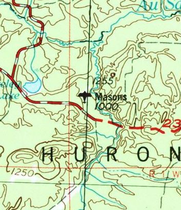
“Masons” Landing Field, as depicted on the 1954 USGS topo map.
According to its FAA Airport/Facility Directory, this small general aviation airport in northern MI was activated in July 1942.
The earliest depiction which has been located of Mason Landing Field was on the 1954 USGS topo map.
The 1963 USGS topo map depicted Mason Landing Field as having 3 unpaved runways.
There were no buildings depicted on the field.
It was still depicted as Mason Landing Field on the 1983 USGS topo map.
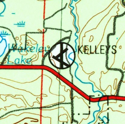
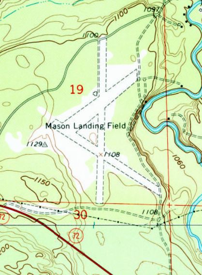
At some point between 1983-89 it was evidently renamed Kelleys Airport,
as that is how it was labeled on the 1989 USGS topo map.
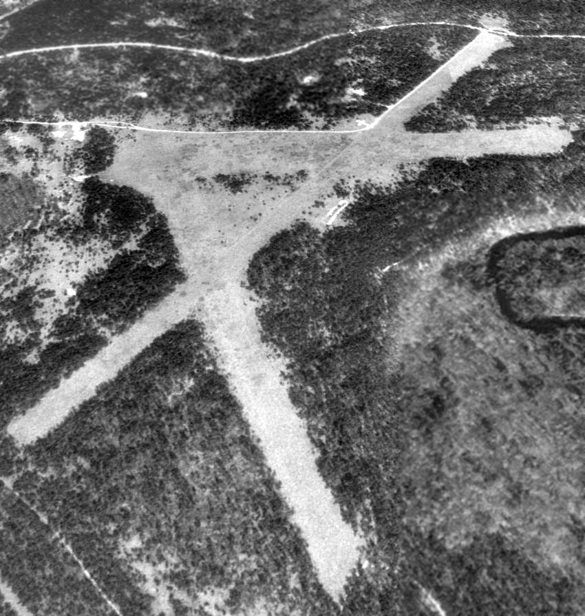
A 1992 USGS aerial view looking northwest showed Kelleys Airport remained intact, but without any sign of any recent aviation usage.
A 9/23/14 aerial view looking southeast by Randy Coller showed Kelleys Airport remained intact, but without any sign of any recent aviation usage.

A 9/23/14 photo by Randy Coller of the foundation of a T-hangar on the northwest side of Kelleys Airport.
Randy Coller reported, “I walked the entire length of one runway & most of the length of the 2nd runway. The runways overgrown with trees - no markings, no windsock.
Automobile tire ruts on the runway. Trees are growing on the runways.
No based aircraft. No evidence of use. The airport is unsuitable for aircraft.
Markers on the runway indicate property is owned by U.S. Forest Service.”
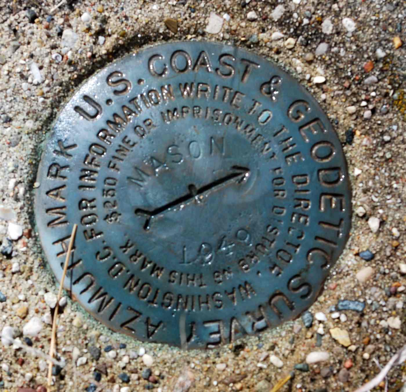
A 4/21/15 photo by Randy Coller of a USGS survey marked next to the foundation of a T-hangar on the northwest side of Kelleys Airport.
As of 2015, the FAA Airport/Facility Directory described Kelleys Airport as having 3 turf runways, with the longest being 3,700' Runway 18/36.
The owner was listed as James Kelley.
However, Randy Coller reported, “I called the U.S. Forest Service on 5/13/15.
They verified that the site is owned by the Forest Service & they wish to have the site abandoned as an airport.
They have no intention of opening it as an airport.”
The site of Kelleys Airport is located northeast of the intersection of Oxbow Road & Route 72.
Thanks to Randy Coller for pointing out this airfield.
____________________________________________________
Vanderbilt Airport (1st location), Vanderbilt, MI
45.15, -84.67 (Northwest of Detroit, MI)
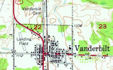
The original Vanderbilt Airport, as depicted on the 1954 USGS topo map (courtesy of Mike Denja).
The original airport for the town of Vanderbuilt was located adjacent to the west side of the town.
The date of establishment of Vanderbilt Airport has not been determined.
The earliest reference which has been located to Vanderbilt Airport
was in the 1938 Commerce Department “Descriptions of Airports & Landing Fields in the U.S.” (courtesy of Mike Denja).
It described Vanderbilt Airport as a municipal field located ¼ mile west of Vanderbilt on the south side of U.S. Highway 27.
Vanderbilt was said to have 2 sandy runways in a cross shape,
measuring 1,800' north/south & 1,400' northeast/southwest.
Vanderbilt Airport may have gone through a period of closure during WW2 (like many other small civilian airports),
as it was not listed among active airfields in the 1945 AAF Airfield Directory (courtesy of Scott Murdock).
The earliest depiction which has been located of Vanderbilt Airport was on the 1954 USGS topo map (courtesy of Mike Denja),
which depicted a single unpaved northwest/southeast runway adjacent to the west side of the town, labeled simply as “Landing Field”.
Note that this is a different runway configuration than described in 1938, so this may have been located in a slightly different spot.
The original Vanderbilt Airport was evidently closed at some point between 1954-55,
as the 1955 USGS topo map showed the property had been covered by the new Interstate 75.
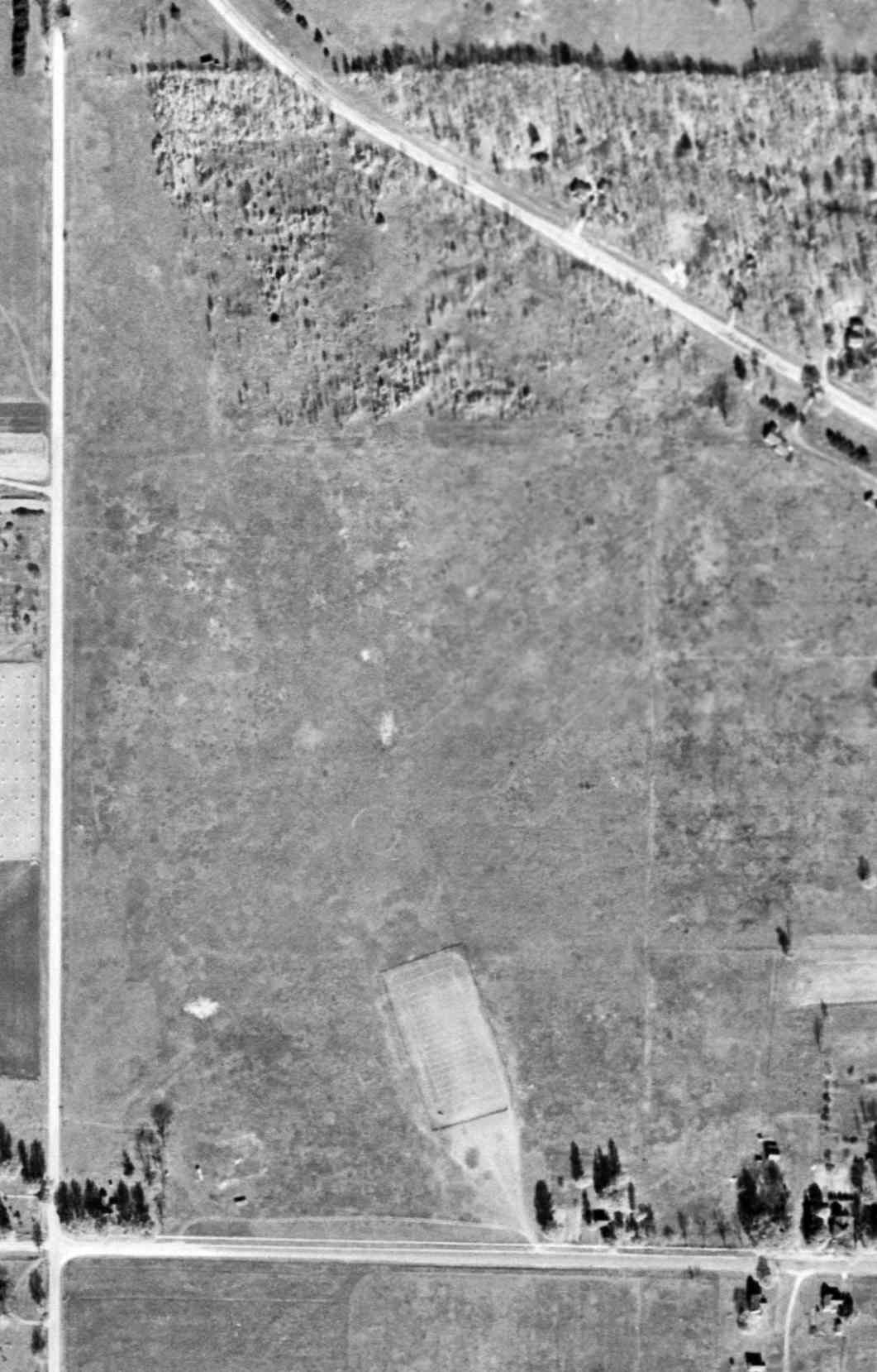
The earliest photo which has been located of the original Vanderbilt Airport was a 10/24/52 USGS aerial view.
It showed traces of a grass northwest/southeast runway, with an airport circle marking in the center.
But what appeared to be a football field had been constructed on the south end of the runway,
and there was no indication of any recent aviation use.
A 2014 aerial view showed no trace of the original Vanderbilt Airport, with Interstate 75 covering the site.
Aaron Matelski reported in 2015 of the original Vanderbilt Airport, “The only thing [that] remains is the old ring for the wind sock.”
The site of the original Vanderbilt Airport is located northwest of the intersection of West Main Street & Lafayette Street.
Thanks to Mike Denja for pointing out this airfield.
____________________________________________________
Vanderbilt Airfield (2nd location), Vanderbilt, MI
45.173, -84.633 (Northwest of Detroit, MI)

The 1979 USGS topo map (courtesy of Mike Denja) depicted 2 runways of the Vanderbilt Airfield, but without any label.
The 2nd location of the Vanderbilt Airfield (2 miles northeast of the town)
may have been established to succeed the original Vanderbilt Airfield (adjacent to the west side of the town),
after the original site was covered by construction of Interstate 75.
As the 2nd location sat adjacent to the east side of a facility labeled on street maps as Center Manufacturing,
it may have served as their private airfield.
The Vanderbilt Airfield may have been constructed at some point between 1955-79,
as it was not yet depicted on the 1955 USGS topo map.
The earliest depiction which has been located of the 2nd location of Vanderbilt Airfield was the 1979 USGS topo map (courtesy of Mike Denja),
which depicted 2 runways without any label.
The Vanderbilt Airfield was not depicted on the 1986 USGS topo map.
The earliest photo which has been located of Vanderbilt Airfield was a 1993 USGS aerial photo,
which depicted 2 unpaved runways with a small hangar on the west side.
A 2013 aerial view looking east at the Vanderbilt Airfield showed the runways remained clear.
A 2014 aerial view by Greg Wilson looking east at the Vanderbilt Airfield showed the runways remained clear.
No airfield at this location was depicted on the 2014 Sectional Aeronautical Chart.
Vanderbilt Airfield is located northeast of the intersection of Interstate 75 & East Alexander Road.
Thanks to Greg Wilson for pointing out this airfield.
____________________________________________________
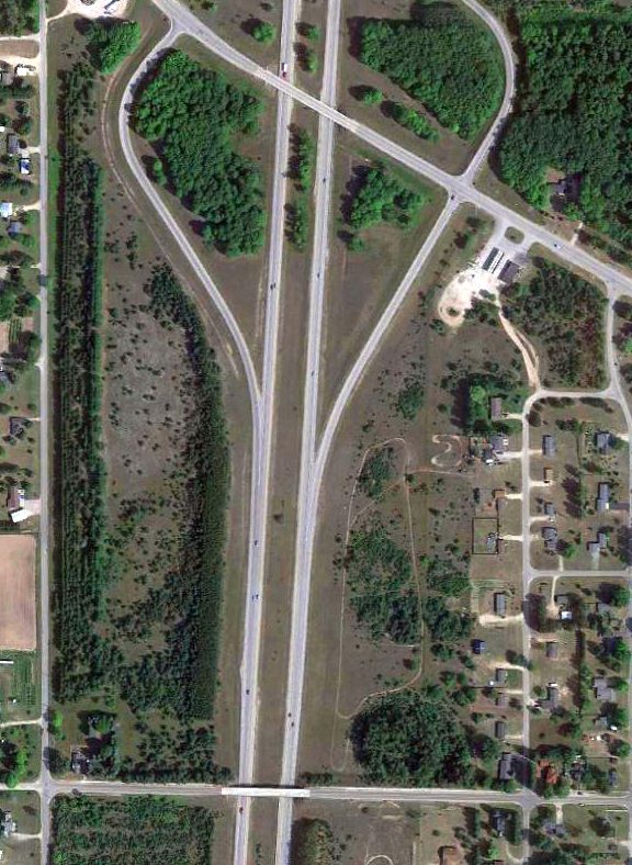
Standish City Airport / Standish Industrial Airport (Y75), Standish, MI
43.98, -83.975 (Northwest of Detroit, MI)

Standish City Airport, as depicted on the 1967 USGS topo map.
This small general aviation airport was evidently established at some point between 1945-67,
as it was not listed among active airfields in the 1945 AAF Airfield Directory (courtesy of Scott Murdock).
The earliest depiction which has been located of Standish City Airport was on the 1967 USGS topo map.
It depicted Standish City Airport as having a single unpaved east/west runway, with a few small buildings on the north side.
The earliest photo which has been located of the Standish City Airport was a 5/21/66 USGS aerial view (courtesy of Mike Denja).
It depicted Standish as having a single east/west runway 9/27, with 1 single-engine aircraft & 5 T-hangars on the north side.
The 1974 USGS topo map depicted Standish City Airport in the same fashion as the 1967 topo map.
A 7/8/83 airport directory (courtesy of John Kielhofer)
depicted Standish Industrial Airport as having a single 2,500' paved Runway 9/27, with a ramp & 1 small building on the southwest side,
and several T-hangars on the north side.
The 1985 USGS topo map labeled it as “Municipal Airport”.
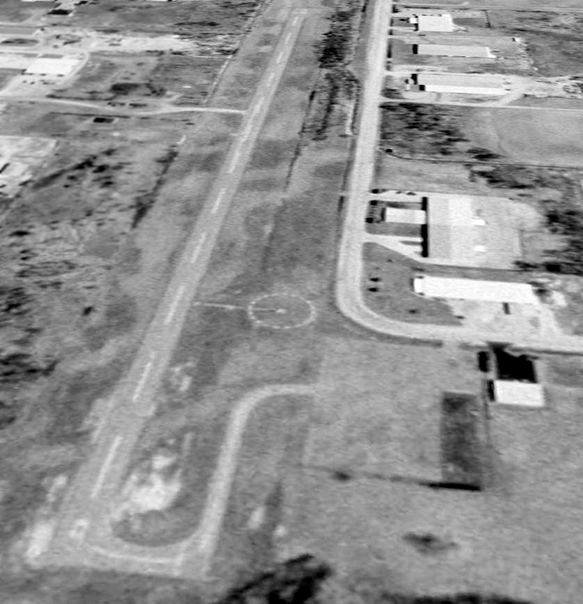
A 4/9/99 USGS aerial view looking northeast depicted Standish City Airport as having a single paved Runway 9/27, with a paved ramp on the southwest side.

The only photo which has been located showing an aircraft at Standish Airport was a 5/31/05 aerial view looking northeast,
which showed one single-engine aircraft on the ramp.

A 10/9/13 aerial view showed closed-runway “X” symbols painted on the Standish runway.
A large quantity of unknown objects were being stored on the runway & the ramp.
According to Wikipedia, Standish Industrial Airport was closed possibly in 2006.
According to its last FAA Airport/Facility Directory data,
Standish Industrial Airport was owned by the City of Standish, and the manager was Greg Norgan.
It had a single 2,500' asphalt Runway 9/27, “in fair condition”.
Standish Industrial Airport is located southwest of the intersection of West Cedar Street & Airpark Drive.
____________________________________________________
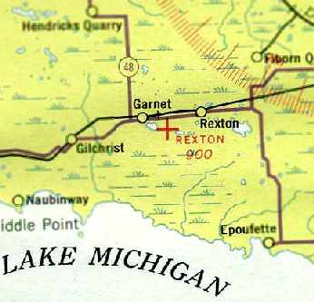
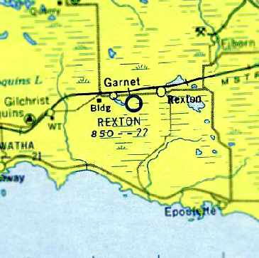
Rexton Airport / D A R Airport, Rexton, MI
46.153, -85.271 (North of Detroit, MI)
Rexton Airport, as depicted on the January 1942 Lake Superior Sectional Chart (courtesy of Chris Kennedy).
This small general aviation airport was established at some point between 1933-34,
as it was not listed among active airfields in the Airport Directory Company's 1933 Airport Directory (according to Chris Kennedy).
The earliest reference to Rexton Airport which has been located
was in 1934 Department of Commerce Airport Directory (courtesy of Chris Kennedy).
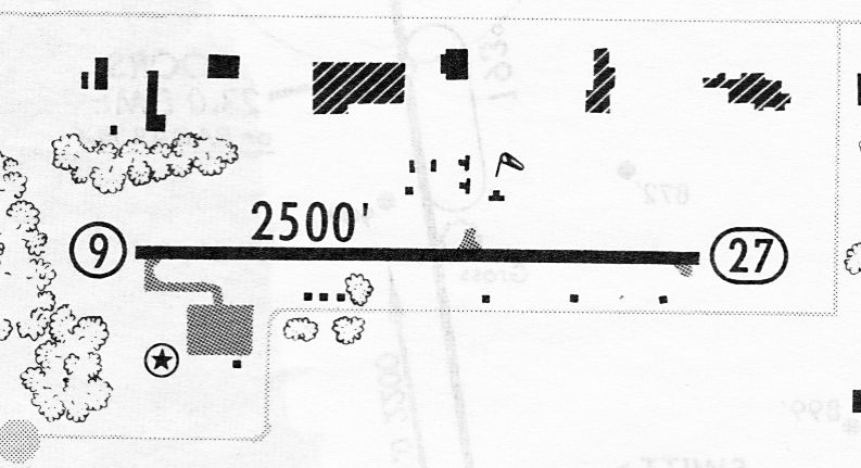
It described “Rexton Airport” as a state airport, located along the south side of Route 2, 1.5 miles southwest of Rexton.
The field was said to have 2 sandy loam runways, oriented in a T-shape, measuring 2,100' east/west & 1,700' north/south.
The earliest depiction of Rexton Airport which has been located
was on the January 1942 Lake Superior Sectional Chart (courtesy of Chris Kennedy).
It depicted Rexton as an auxiliary airfield.
On the December 1942 4M Regional Aeronautical Chart (according to Chris Kennedy) it was still labeled as “Rexton”.
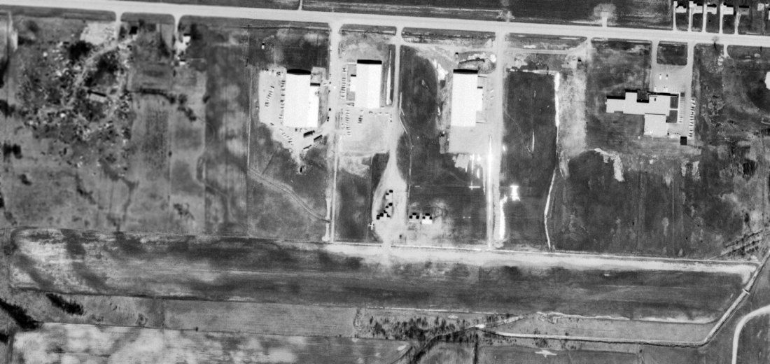
The earliest photo which has been located of Rexton Airport was a 9/19/43 aerial view looking north (courtesy of Brian Rehwinkel).
Brian Rehwinkel observed, “The photo was taken in the middle of the war & it shows an empty field, which seems par for the course for this airfield.”
At some point between 1942-44, it was apparently renamed as “D A R Airport”,
as that is how it was labeled on the June 1944 Lake Superior Sectional Chart (courtesy of Chris Kennedy).
It depicted “D A R” as an auxiliary airfield.
It was still listed as “D A R” in the December 1944 Army/Navy Airfield Directory (according to Chris Kennedy).
The airfield was evidently renamed “Rexton Municipal” at some point between 1944-45,
as that is how it was listed in the 1945 Haire Publishing Company Airport Directory (according to Chris Kennedy).
It was said to be owned by the State, and its condition was described as “Rough. Not maintained.”
An admittedly low-resolution 6/1/53 aerial view depicted Rexton Airport as having 2 perpendicular unpaved runways.

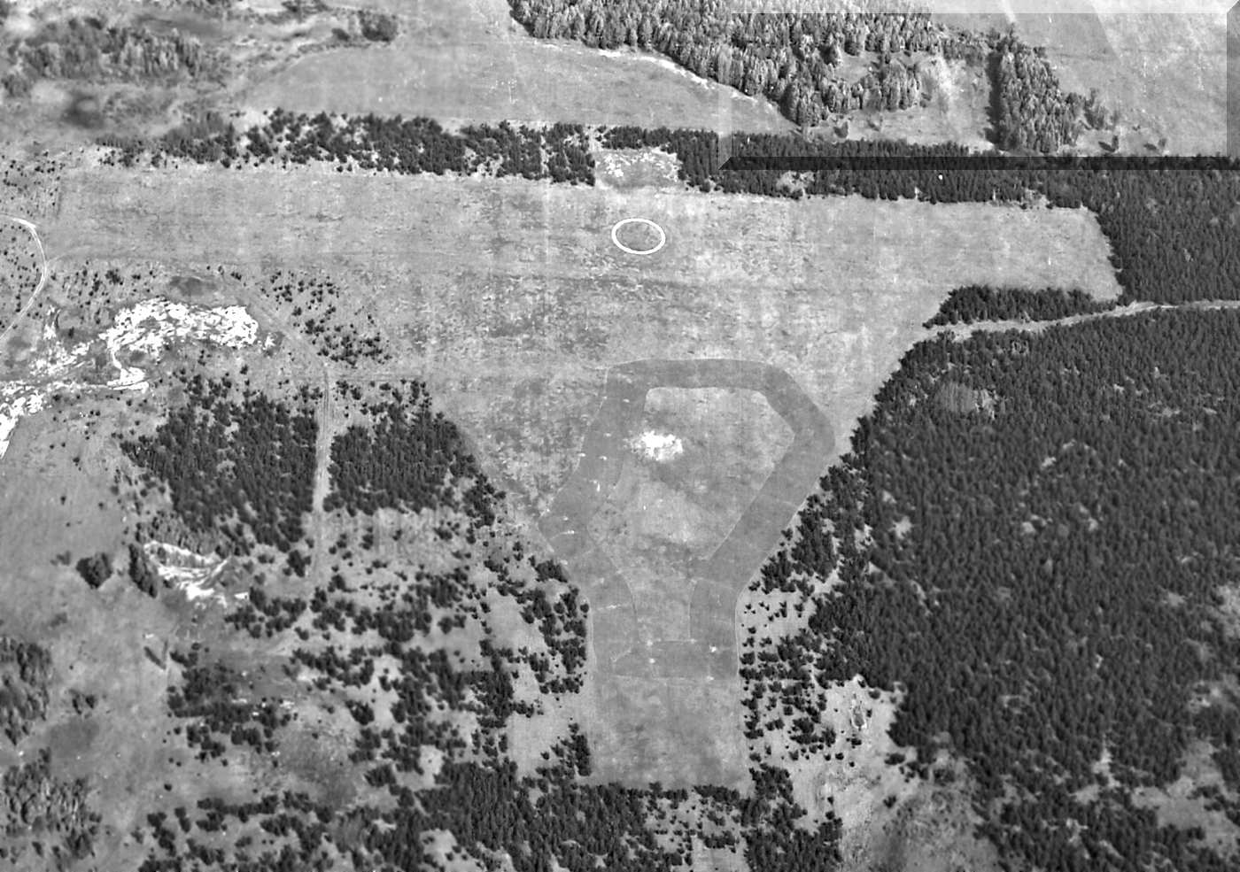
The last photo which has been located of the Rexton Airport while it was in operation was a 5/2/55 USGS aerial view (courtesy of Brian Rehwinkel).
It depicted Rexton as having 2 perpendicular unpaved runways, with a prominent airport circle marking in the center.
There did not appear to be any buildings at the site.
The last aeronautical chart depiction which has been located of the Rexton Airport
was on the May 1957 Lake Superior Sectional Chart (courtesy of Chris Kennedy).
It depicted Rexton as having a 2,200' unpaved runway.
Rexton Airport was still listed in the 1957/58 Aviation Week Airport Directory (according to Chris Kennedy).
The field's status was described as "Emergency field only."
Rexton Airport was still depicted on the 1958 USGS topo map.
Rexton Airport was evidently closed (for reasons unknown) at some point between 1958-61,
as it was no longer listed among active airfields in the 1961 Aviation Week Airport Directory (according to Chris Kennedy).
No airfield or airfield features were depicted at the site of the Rexton Airport on the 1963 or 1973 USGS topo maps,
although the 1973 topo map labeled “Airport Road”, but not the airport itself.
In the 1998 USGS aerial photo the airport circle marker was still plainly evident.
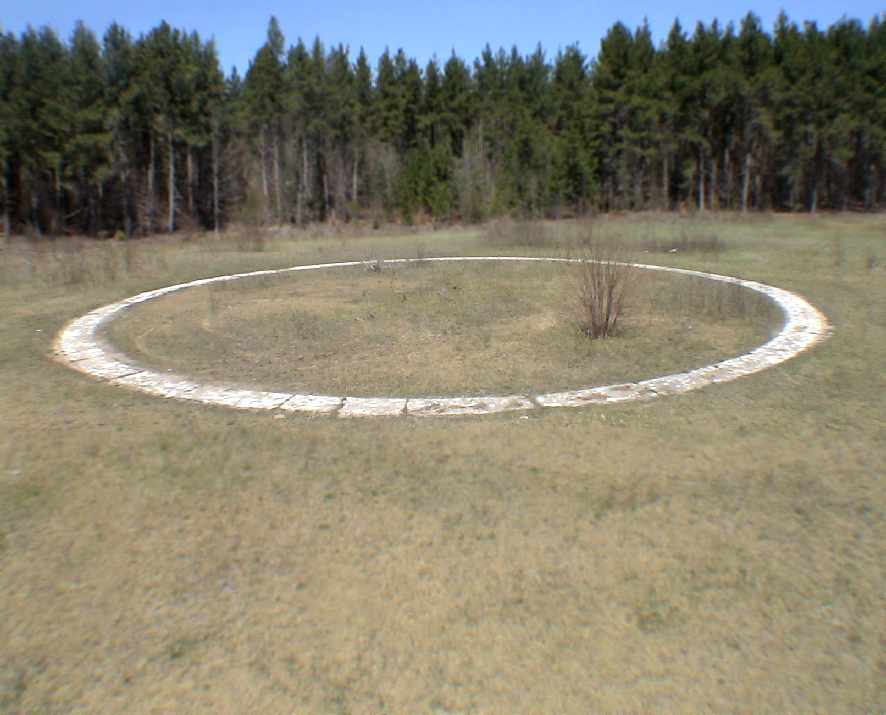
A 2007 photo by Will Denihan of the former airport circle marker,
which remains remarkably completely intact at the site of the Rexton Airport.
Will reported, “My dad has a cabin just a couple of miles from Rexton,
and there is a dirt road named 'Airport Road' which makes a mile or so loop around a forested area with a concrete circle in it's midst,
the circle is roughly 150' in diameter & was obviously painted white at some point in the past,
possibly with reflective paint of some sort.
There are sections of the circle that still have remarkably good paint.”
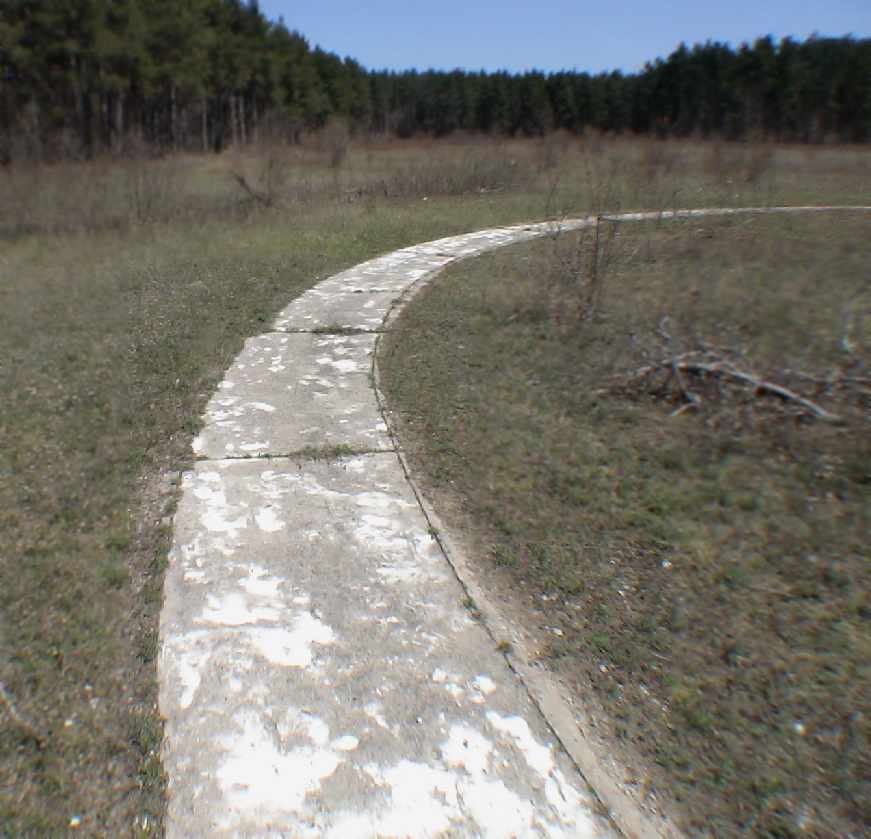
A closeup 2007 photo by Will Denihan of the former airport circle marker at the site of the Rexton Airport.
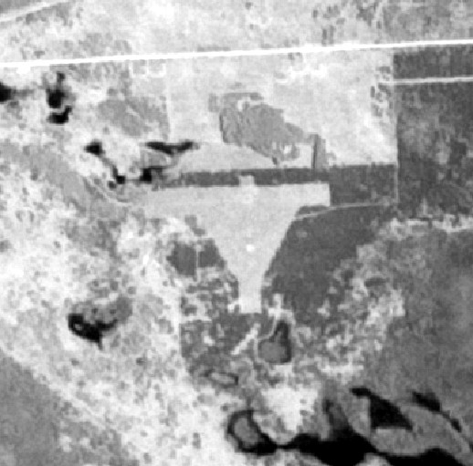
In a 7/26/10 aerial photo, the airport circle marker was still plainly evident, along with the presumed airfield outline.
____________________________________________________
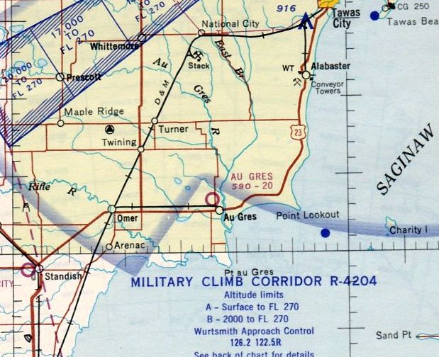
Au Gres Airport (3Y7), Au Gres, MI
44.053, -83.7 (North of Detroit, MI)
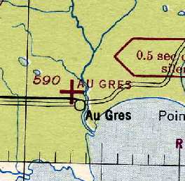
Au Gres Airport, as depicted on the 1944 Lake Huron Sectional Chart (courtesy of Chris Kennedy).
Photo of the airport while open has not been located.
The Au Gres Airport was dedicated on July 4, 1936,
according to a postmark commemorating the occasion (courtesy of Mike Denja).
The earliest listing of Au Gres Airport which has been located
was in The Airport Directory Company's 1937 Airports Directory (courtesy of Bob Rambo).
It described Au Gres as having two 2,000' grass runways.
The Airport Directory Company's 1938 Airports Directory (courtesy of Chris Kennedy)
described Au Gres in the same manner.
The 1946 MI Airport Directory (courtesy of Doug Ranz)
depicted Au Gres as having two 2,000' turf runways.
The 1963 AOPA Airport Directory (courtesy of Chris Kennedy)
described Au Gres as having two 2,000' sod runways: 4/22 & 13/31.
The last aeronautical chart depiction which has been located of Au Gres Airport
was on the May 1965 Lake Huron Sectional Chart (courtesy of Ron Kunse).
It depicted Au Gres as having a 2,000' unpaved runway.

The last depiction which has been located showing Au Gres Airport while in operation was on the 1976 USGS topo map (courtesy of Mike Denja).
It depicted Au Gres Airport as having 2 unpaved runways, with a single building on the northeast side.
The 1982 AOPA Airport Directory (courtesy of Ed Drury)
described Au Gres as having two 2,000' sod runways: 5/23 & 14/32.
Au Gres Airport evidently closed (for reasons unknown) at some point between 1982-86,
as it was not listed in the 1986 Flight Guide (according to Chris Kennedy).
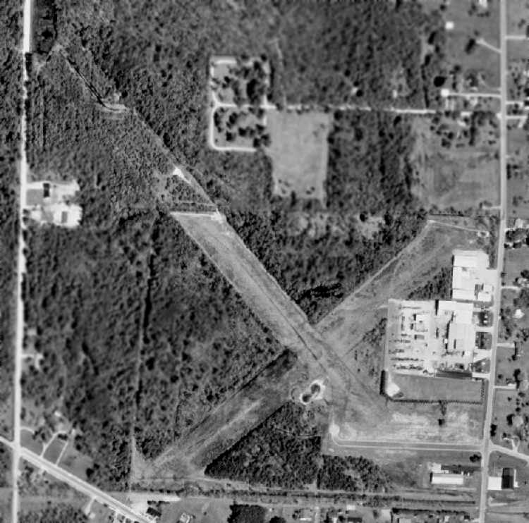
By the time of the 1998 USGS aerial photo,
several buildings had been built over the eastern portion of the airfield,
and a new street had been built over a portion of the southeast end of Runway 14/32.
However, the outline of the majority of both runways still remained quite recognizable.
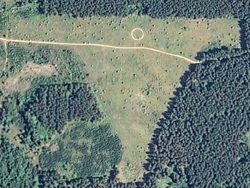
The “Old Airport Disc Golf Course” was established in 1999 on the site of Au Gres Airport.
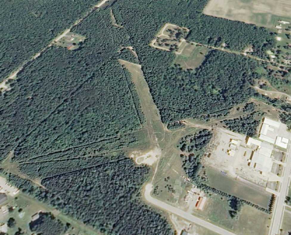
In a 7/26/10 aerial view looking northwest, the outline of the majority of both runways still remained quite recognizable.
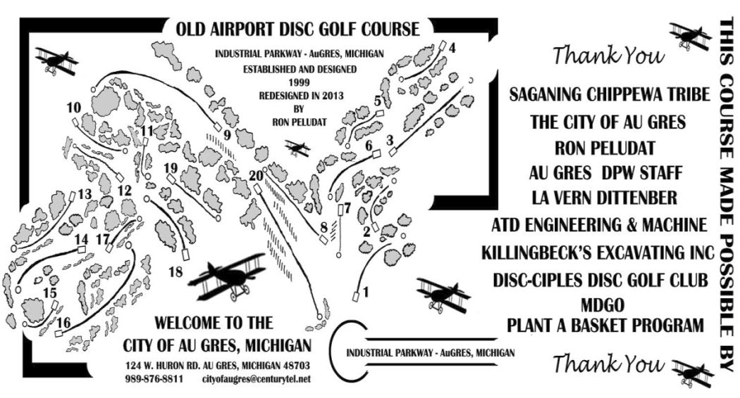
A 2013 map of the “Old Airport Disc Golf Course” located on the site of Au Gres Airport (courtesy of Mike Denja).
The site of Au Gres Airport is located northwest of the intersection of North Court Street & West Cherry Street.
____________________________________________________
Marquette County Airport (original location) (MQT), Marquette, MI
46.533, -87.56 (North of Green Bay, WI)
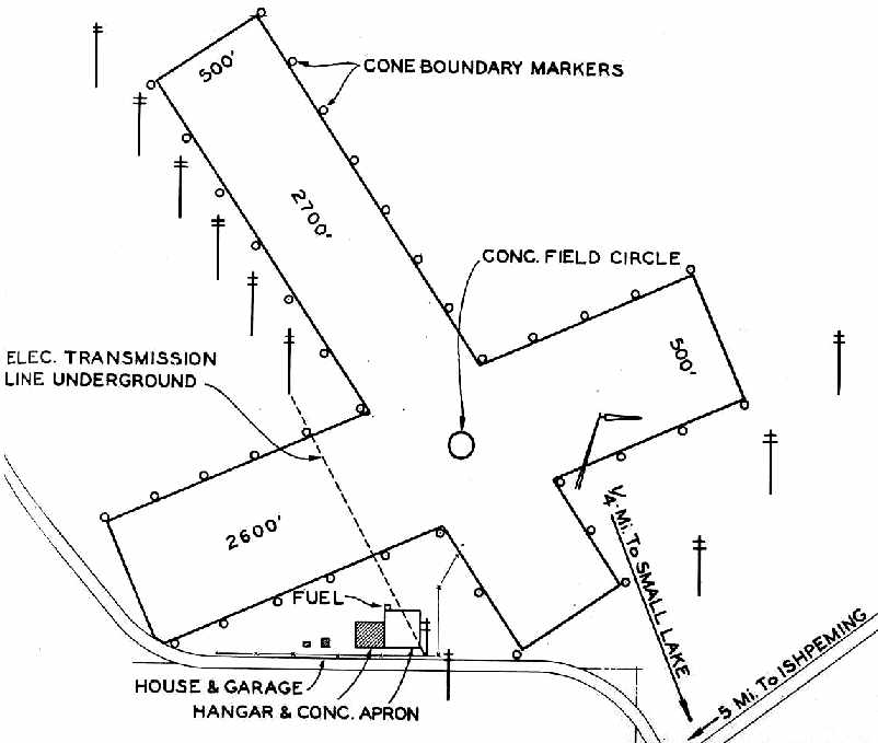
Marquette County Airport, as depicted on the 1940 MI Airport Directory (courtesy of Chris Kennedy).
The Marquette County Airport was dedicated on July 12, 1932,
according to a postmark commemorating the occasion (courtesy of Mike Denja).
The earliest depiction of the Marquette County Airport which has been located
was in the 1940 MI Airport Directory (courtesy of Chris Kennedy).
It depicted the “Marquette County Landing Field” as having 2 unpaved runways
(2,700' northwest/southeast & 2,600' northeast/southwest).
A hangar & concrete apron were depicted south of the runway intersection.
The earliest aeronautical chart depiction of the Marquette County Airport which has been located
was on the 1942 Regional Aeronautical Chart (courtesy of Chris Kennedy).
The 1946 MI Airport Directory (courtesy of Doug Ranz) depicted Marquette County Airport
as having 2 turf runways (2,700' & 2,600'), and a hangar south of the runway intersection.
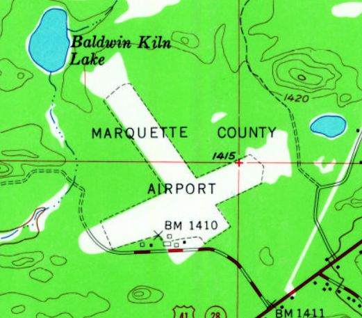
The 1953 USGS topo map depicted Marquette County Airport as having 2 unpaved runways, with a few small buildings along the southwest side.
According to David York, the older terminal at Marquette County Airport
(the brown brick building) was built in 1957, and was also used by the U.S. Weather Service.
Marquette had apparently gained paved runways (in a different configuration as well) at some point between 1946-60,
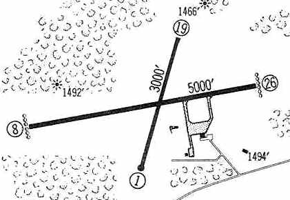
as the 1960 Jeppesen Airway Manual (courtesy of Chris Kennedy)
depicted the field as having 2 paved runways: 5,000' Runway 8/26 & 3,000' Runway 1/19.
A ramp on the southeast side had 2 buildings.
An aerial view looking north at the Marquette County Airport,
from the 1962 Sky Eye Northern Michigan Airport Directory (courtesy of Chris Kennedy).
The field was described as having 2 paved runways: 5,000' east/west & 3,000' north/south.
Marquette County Airport was listed among active airports in the 1962 AOPA Airport Directory,
with 2 paved runways, and the operator listed as Peninsula Air Service.
In the 1982 AOPA Airport Directory (courtesy of Ed Drury),
the field was described as having a 6,500' asphalt Runway 8/26 & a 3,000' asphalt Runway 1/19.
The operators were listed as Marquette Executive Air & Northern Airmotive Inc.
According to David York, in 1983 the older terminal building at Marquette County Airport
was replaced by a new, larger terminal building.
However, it was not destined to serve a very long life.

A 1988 photo by Scott Anttila of the Northern Airmotive hangar at Marquette County Airport.
Scott recalled, "I learned to fly at MQT, miss the airport much, and do not want parts of it to be forgotten."
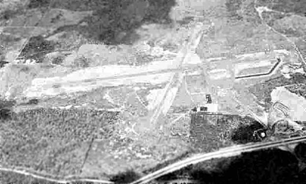
A 1994 USGS aerial photo, taken while the field was still open.
When nearby KI Sawyer AFB was closed by the Air Force,
it became the "new" Marquette County Airport in 1999,
and the original Marquette County Airport was closed.
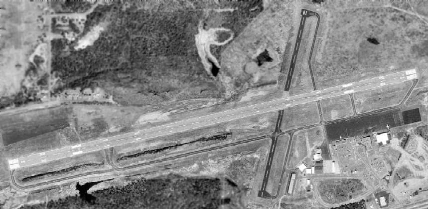
At the time of its closure, Marquette County Airport consisted of 2 paved runways
(the longest, 8/26, was 7,000' long), taxiways, ramps & hangars.

A 2003 photo by David York looking along the closed Runway 26 at the former Marquette County Airport.
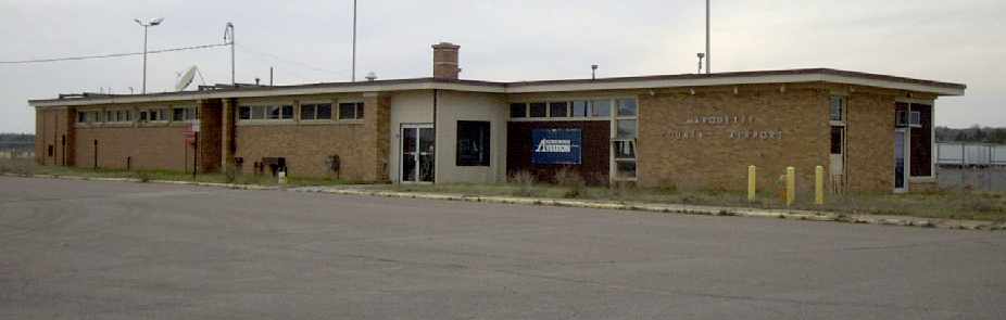
A 2003 photo by David York of the old terminal building at the former Marquette County Airport.

A 2003 photo by David York of the new terminal building at the former Marquette County Airport.
This public building was abandoned only 16 years after it was built.
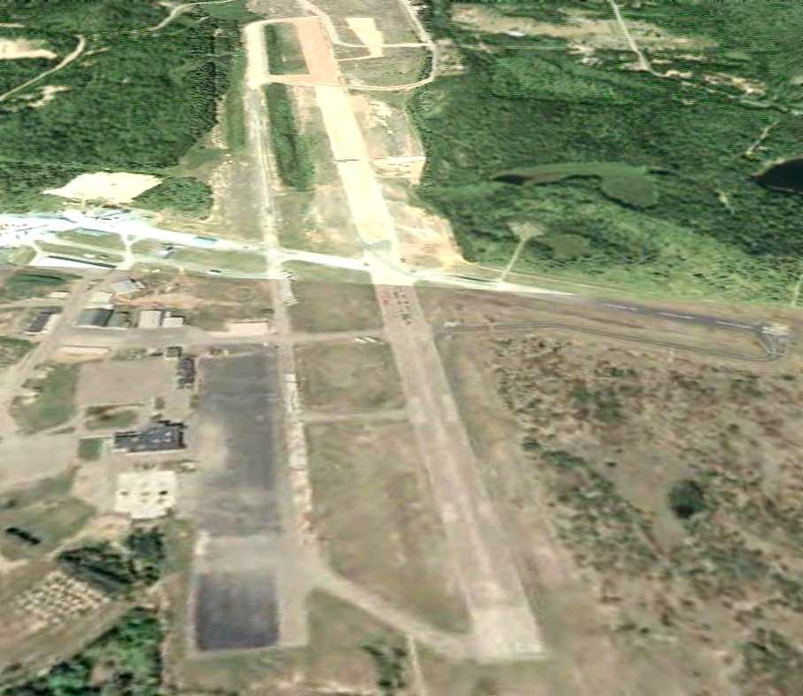
A 6/30/06 aerial view looking west showed the extensive aviation infrastructure remaining at the former Marquette County Airport.
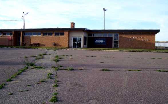
A 2007 photo by John Grego of the abandoned old terminal building at the former Marquette County Airport.
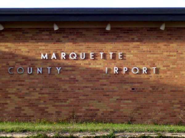
A 2007 photo by John Grego of the sign on the abandoned old terminal building at the former Marquette County Airport.
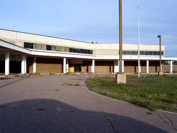
A 2007 photo by John Grego of the abandoned new terminal at the former Marquette County Airport.
____________________________________________________
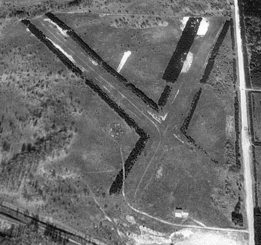
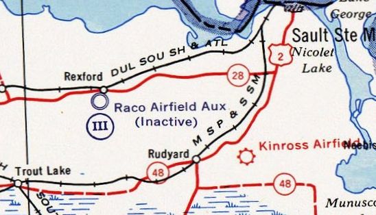
Raco Landing Field / Raco Army Airfield, Raco MI
46.352, -84.815 (North of Detroit, MI)

“Raco Landing Field”, as depicted on the 1940 MI Airport Directory (courtesy of Chris Kennedy).
Photo of the airfield while open has not been located.
This site has had (at least) 6 completely distinct uses over the years.
The property adjacent to the west side of the airfield has a series of rifle ranges
that were established before the first World War.
The date of construction of the first airfield at Raco has not been determined.
A “Raco Landing Field” was depicted on the south side of Route 28, 4 miles west of the town of Raco,
on the 1940 MI Airport Directory (courtesy of Chris Kennedy).
It depicted the field as consisting of a 2,000' square, surrounded by “disced boundary markers”.
The site of the pre-WW2 civilian Raco Landing Field was evidently reused by the military at some point after 1940
for the construction of a much more elaborate military airfield,
intended to provide protection to the Sault Sainte Marie locks.
The earliest aeronautical chart depiction of Raco Field which has been located
was on the 1942 Regional Aeronautical Chart (courtesy of Chris Kennedy).
It depicted Raco as an auxiliary airfield.
Raco Field may have been under the administrative control of Alpena AAF.
As no threats materialized to the locks,
the airfield was apparently little-used, or possibly never used at all.

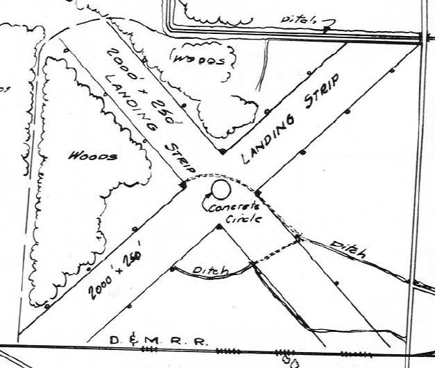
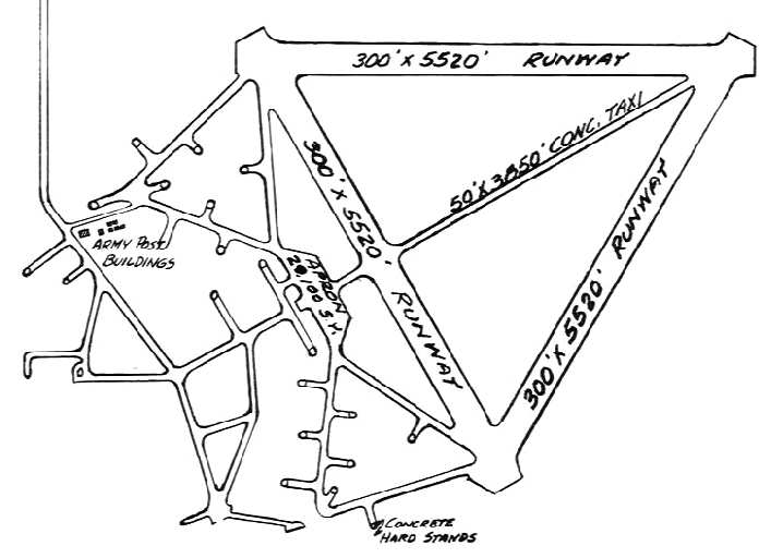
An undated (circa 1945?) map of “Raco Airport” (from the St. Louis National Personnel Records Center, courtesy of Ron Plante).
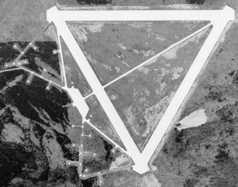
It depicted Raco as having 3 paved runways, along with an extensive network of concrete hardstands to the west of the runways.
It is possible that the Raco military airfield was intended to be reused as a civil airport after the end of WW2,
as the 1946 MI Airport Directory (courtesy of Doug Ranz) listed it as the "Raco Airport".
Although it was depicted as being adjacent to the property of the "Fort Brady Military Reservation",
there was no mention of any military ownership of the airfield itself.
The Raco airfield was depicted as having three 5,520' runways,
along with its extensive network of concrete hardstands to the west of the runways.
According to Dale Lutz (whose grandfather performed contract work at RACO during the 1960s),
during WW2 & the early part of the Cold War,
the Army reused the western portion of the Raco property as an anti-aircraft artillery site.
Two triangular shaped roads were laid out, extending outward from the western runway,
along which were situated a total of 18 heavy AAA guns.
The guns were apparently placed on top of the square pads,
while a number of 20-30' diameter concrete "silos" were located around the guns,
in which was stored their ammunition.
The silos were filled with concrete in the 1980s.
In Lutz's words, "These guns were poised to intercept bomb runs by the Nazis or the Ruskies
at low altitudes into the entrance of the Soo locks & shipping narrows tens of miles away."
A 1947 Army Corps of Engineers map (courtesy of Mike Denja) depicted “Raco Airfield Aux” as inactive.
The 1951 USGS topo map (courtesy of Mike Denja) depicted Raco Field
along with the numerous anti-aircraft artillery pads to the southwest.
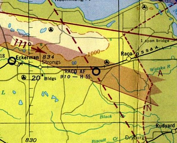
"Raco AF" was still depicted as a military airfield on the November 1952 Lake Superior Sectional Chart,
with a 5,500' paved runway.
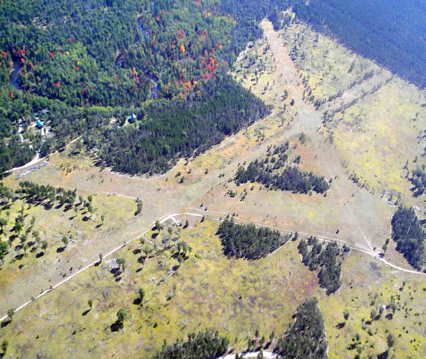
The earliest photo which has been located of Raco AAF was a 6/2/53 aerial view (courtesy of Mike Denja).
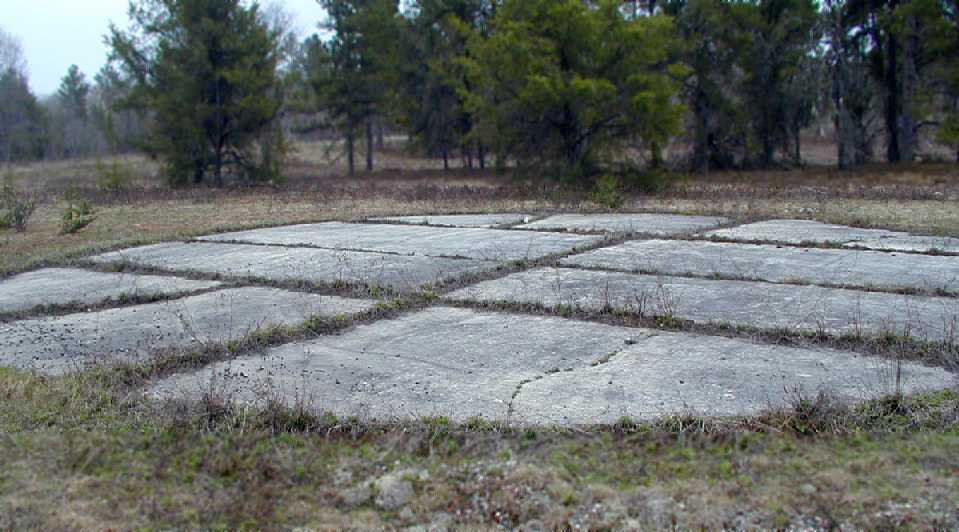
It depicted Raco as having 3 concrete runways, along with the numerous anti-aircraft artillery pads to the southwest.
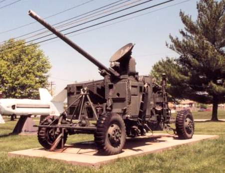
A 75mm Skysweeper gun on display at the Army Ordnance Museum, Aberdeen, MD.
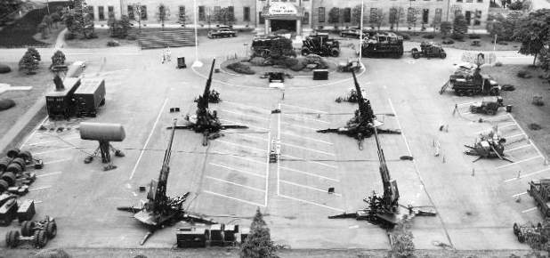
A 1955 static display of Army Antiaircraft command 90mm & 75mm Skysweeper guns & radars.
Although the type of guns used at Raco is unknown,
an official history of the Army Antiaircraft Command includes the following:
"ARAACOM AW battalions defended linear targets, like locks & airfields, from air attack.
A new weapon system was developed & fielded in the early 1950s to replace their 40mm guns & 0.50 caliber machine guns.
Called the Skysweeper, it was the first weapon to emerge in the atomic age
with radar, computer & gun on one carriage, a fully integrated gun & fire-control system.
With its 75mm gun, the Skysweeper could find & track approaching aircraft as far away as 15 miles
and destroy air targets as far away as 4 miles.
Its automatic loading & firing capability allowed it to fire 45 rounds/minute.
Peak deployment for Skysweeper battalions was achieved in the mid-1950s when 8 battalions were deployed.
As more & more Nike missile systems were deployed,
ARAACOM slashed the number of AAA guns in the command in the last half of 1957.
By the end of the year only three 75mm Skysweeper battalions remained,
one at Sault Sainte Marie." [which is apparently referring to Raco].
"Raco AF" was still depicted as a military airfield on the 1957 Lake Superior Sectional Chart (according to Chris Kennedy).
Part of the airfield property was later reused by the Air Force to build a launch site
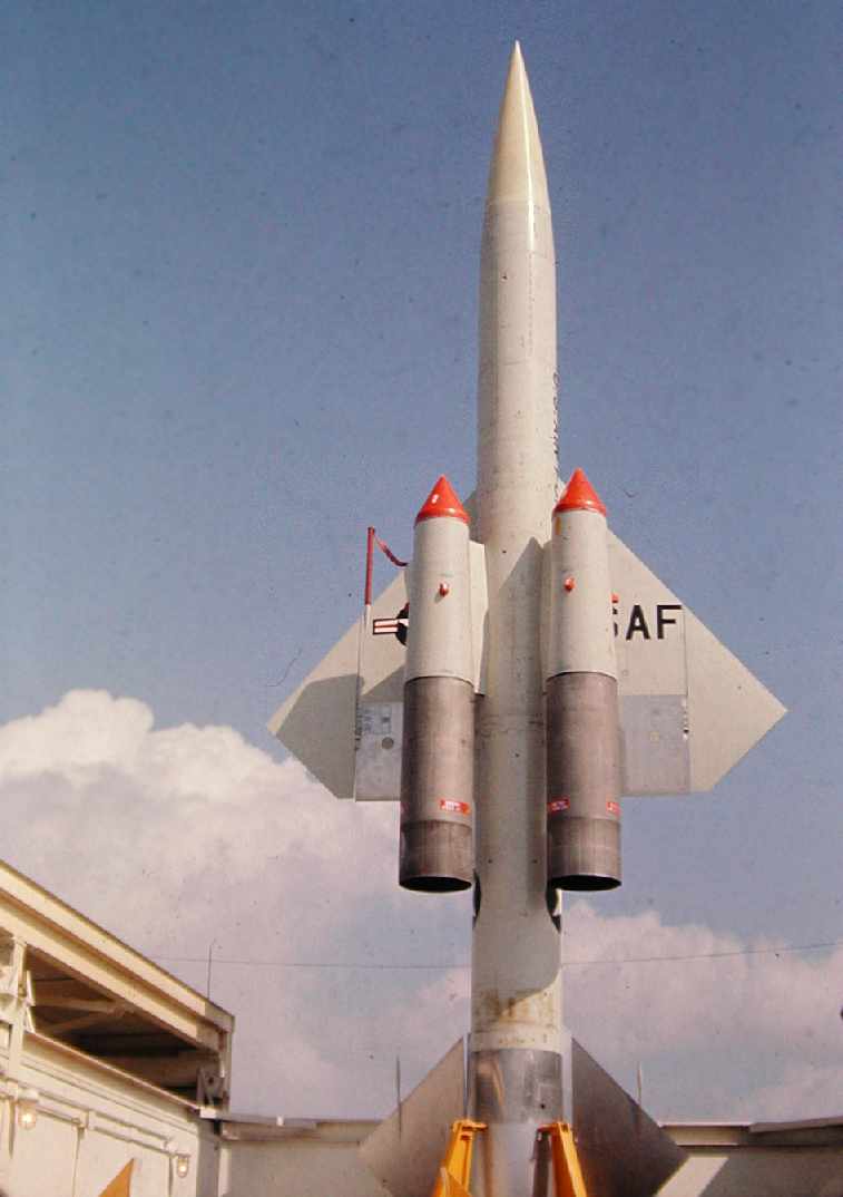
for the huge BOMARC ramjet surface-to-air missiles.
The BOMARC was a long-range surface to air missile,
intended to shoot down Soviet bombers with a nuclear warhead.
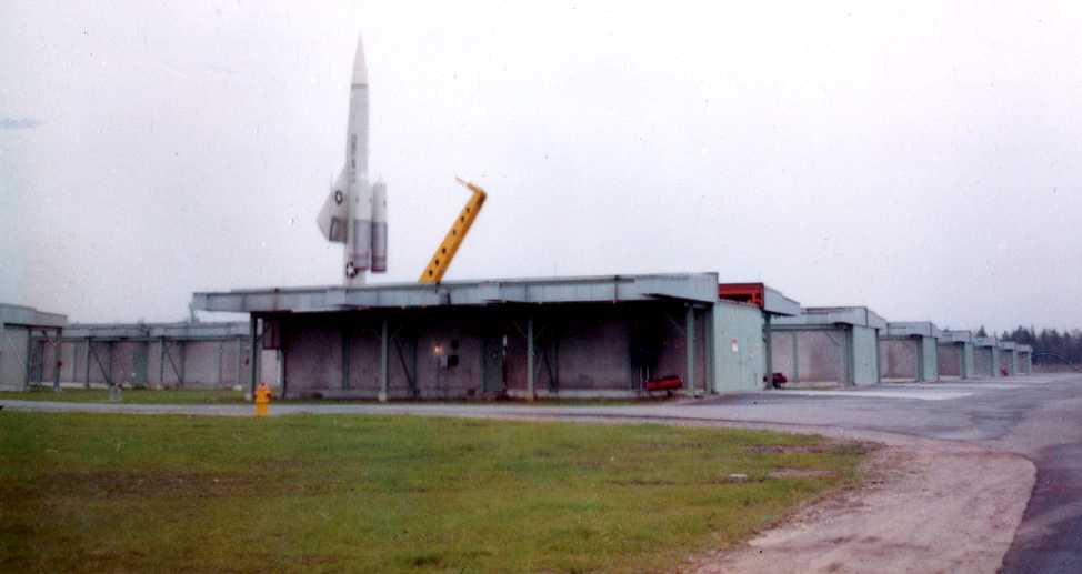
An undated photo of a BOMARC-B missile raised into firing position for the dedication of the Raco BOMARC installation.
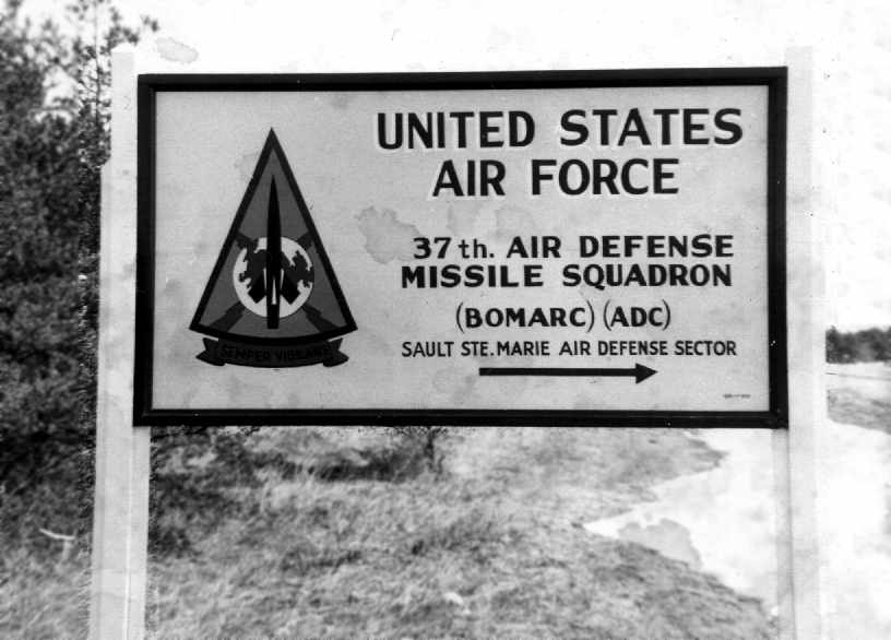
This facility was known as the Kincheloe AFB BOMARC site,
and it was manned by the 37th Air Defense Missile Squadron starting in 1960.
The BOMARC site was a rectangular installation, just southeast of the runways.
It operated the 2nd-generation IM-99B version of the BOMARC missile.
The site consisted of a grid of 28 individual missile launcher buildings on the south end,
along with larger missile assembly buildings on the north end.
A circa-1963 photo by John Frye of a BOMARC-B missile at Raco.
John Frye recalled, "I was stationed at the BOMARC installation as a missile mechanic from July 1962 to December 1965.
The area to the West was indeed an old military training site.
We used the area for carbine qualification one year.
There was a few ponds or swampy areas out there,
and a friend found live Canadian artillery shells in one of the small lakes which had to be recovered by the military.
There was a ring of concrete sample cores (probably from the runway construction)
located in the very center of the runway complex.
In the center was a wooden pole that had a wind sock on it that had rotted off & fallen years before, possibly from WW2.
I remember brass fittings in the apron area that was intended for electrical & water supply to aircraft I assume, very first class.
I was never able to find out if troops had been stationed there or if it had ever been active.
It must have taken a lot of concrete to build since the cores found in the center of the complex
were about a foot or more long (I'll bet they are still there).
While we were there, the only aircraft that landed there was a T-33 that ran out of fuel & helicopters from Kincheloe.
Our 37th ADMS chow hall had quarters for about a dozen men.
I spent many weekends on standby duty out there, and would ride a bicycle around the runways & hike in the area.
Some of the area to the South had been planted with pines about that time,
but the center of the runways was open grasslands."
A circa-1963 photo by John Frye of the sign at the entrance to the Raco missile site, on the highway at the end of the north/south runway.
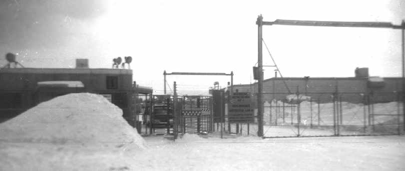
A circa-1963 photo by John Frye of the sally port & finger gate going into the support area of the Raco missile site.
John Frye recalled, "We followed the old runway down to the chow hall
and there was a Quonset hut housing a fire engine with storage & the chow hall just beyond, both built on the runway.
A road ran up over the hill to the launch area & support buildings between these 2 buildings.
A steel Butler Building was on the hill north of the complex that had engineering & a meeting hall at one end.
Just north of the Butler building was a deep covered pit that a temporary acting 1st Sergeant built as a retreat in case of a nuclear attack.
It was big enough to hold about 60 troops beneath pierced steel planking in a sand pit.
I guess the guy had a fear of being blown up.
I kind of remember it being covered up before I left there in December of 1965."
It is not known if Raco was ever formally reused as a civil airport,
but it appears as if it did not.
The runways at Raco were occasionally used by small planes (most of the Forrest Service) during the 1960s,
according to a former Raco BOMARC squadron member.
The Raco BOMARC facility was closed in 1972.
David McLaren recalled, "I visited Raco AAF back in 1974 after spotting it from a B-52 at 20,000 feet.
At that time the seedlings had just been planted.
The only remaining Air Force structure was a mess hall,
which still had the stainless steel coolers & tables.
The missile buildings were intact, and although the launching equipment had been removed,
the buildings still had their heaters installed."
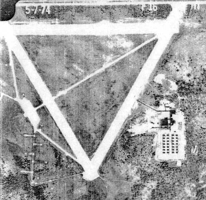
A 5/7/1974 aerial photo (courtesy of Ron Plante) showed the 3 runways, taxiways, and ramp area of the Raco airfield,
along with the Skysweeper antiaircraft gun pads on the southwest side,
and the still-intact launcher buildings of the BOMARC missile site on the southeast side.
In 1985, the Army Corps of Engineers began a project intending to demolish buildings at Raco.
Krygoski Construction Company won a contract to perform the work.
This eventually resulted in a 1996 lawsuit.
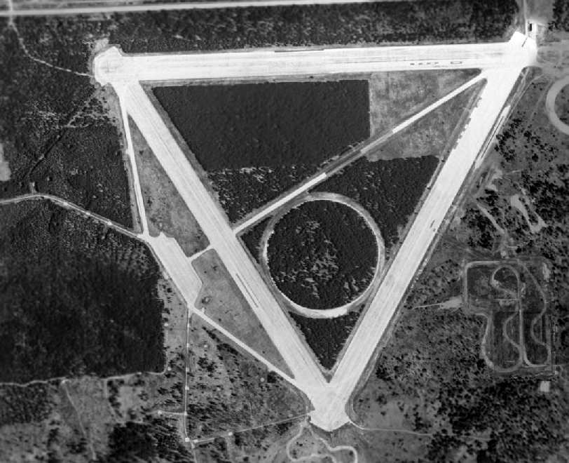
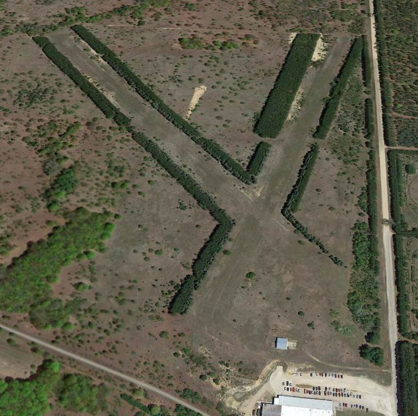
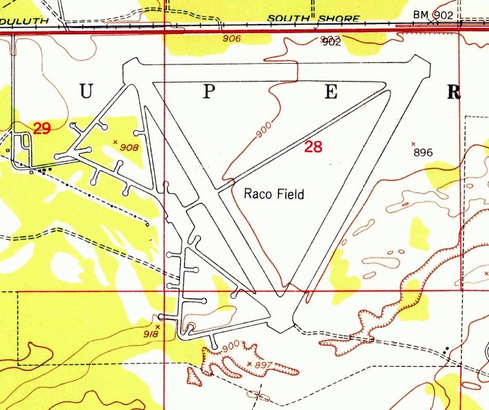
As of the 1994 USGS aerial photo, the airfield consisted of three 6,600' runways, taxiways, and a ramp area,
all of which still existed in very good condition.
A circular automobile testing track had been added in the center of the runways at some point between 1974-94.
All of the buildings associated with the BOMARC launch site had also been removed at some point between 1974-94,
replaced with a serpentine vehicle testing track.
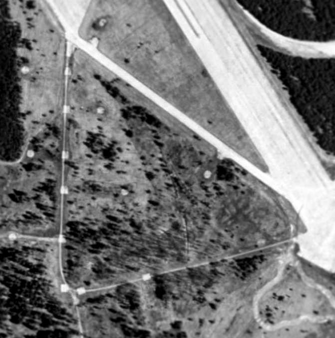
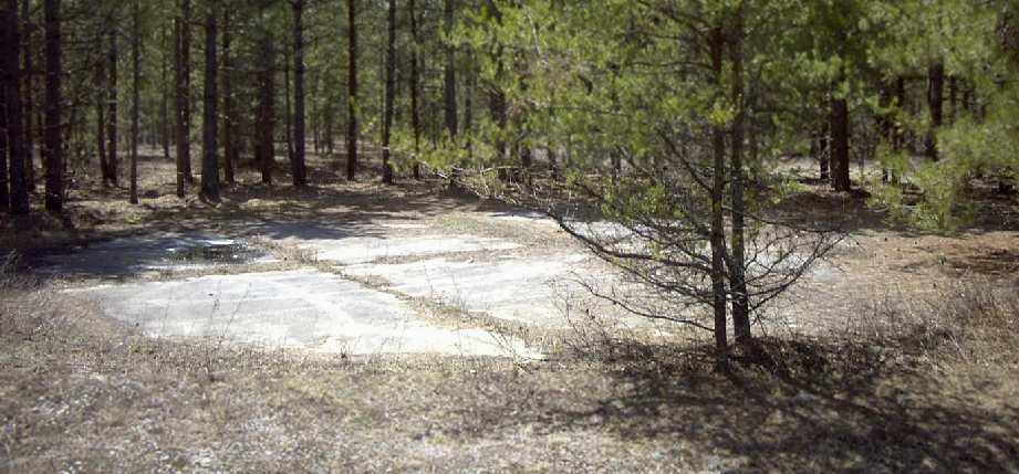
A close-up from the 1994 USGS aerial view showing the former Skysweeper Anti-Aircraft Artillery pads on the southwest corner of the Raco site.
John Frye recalled, "In 2001 the concrete base for the finger gates was still there, but everything else was gone with just some rubble."

A 2002 photo by David York of remains at Raco AAF.
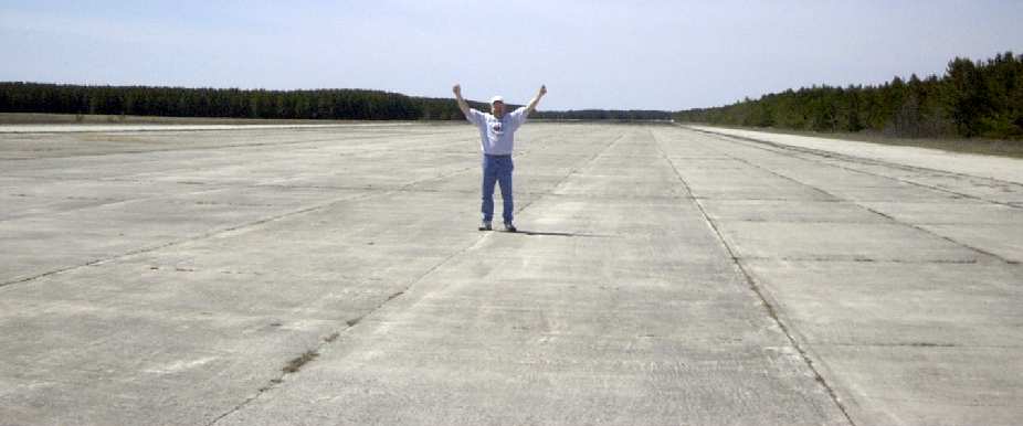
A 2002 photo of David York on a runway of Raco AAF.
A 2002 photo by David York of the remains of the former BOMARC missile installation adjacent to Raco AAF.
A 2002 photo by David York of what is presumably the remains
of a Skysweeper artillery pad in the woods adjacent to Raco AAF.
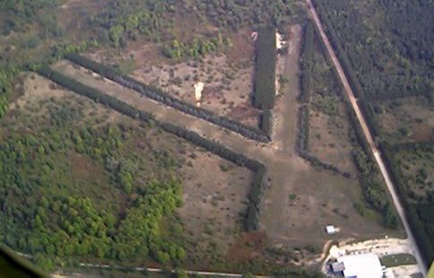
The former runways at Raco are now used by Smithers Scientific Services as an automobile testing site,
primarily during the winter.
No original military buildings remain,
other than concrete foundations for the BOMARC launcher shelters.

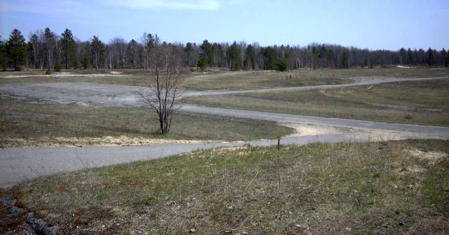
A circa 2007 photo looking southwest at a Smithers Scientific Services building, with the Raco runways in the background.
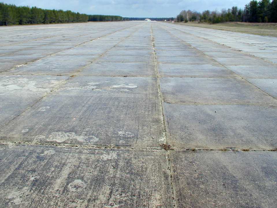
A 2008 photo by Eric Douglas looking along a former Raco runway.
He attended a BloKarting event using the former runways.
A 2008 photo by Eric Douglas of what is presumably the remains
of a Skysweeper artillery pad in the woods adjacent to Raco AAF.
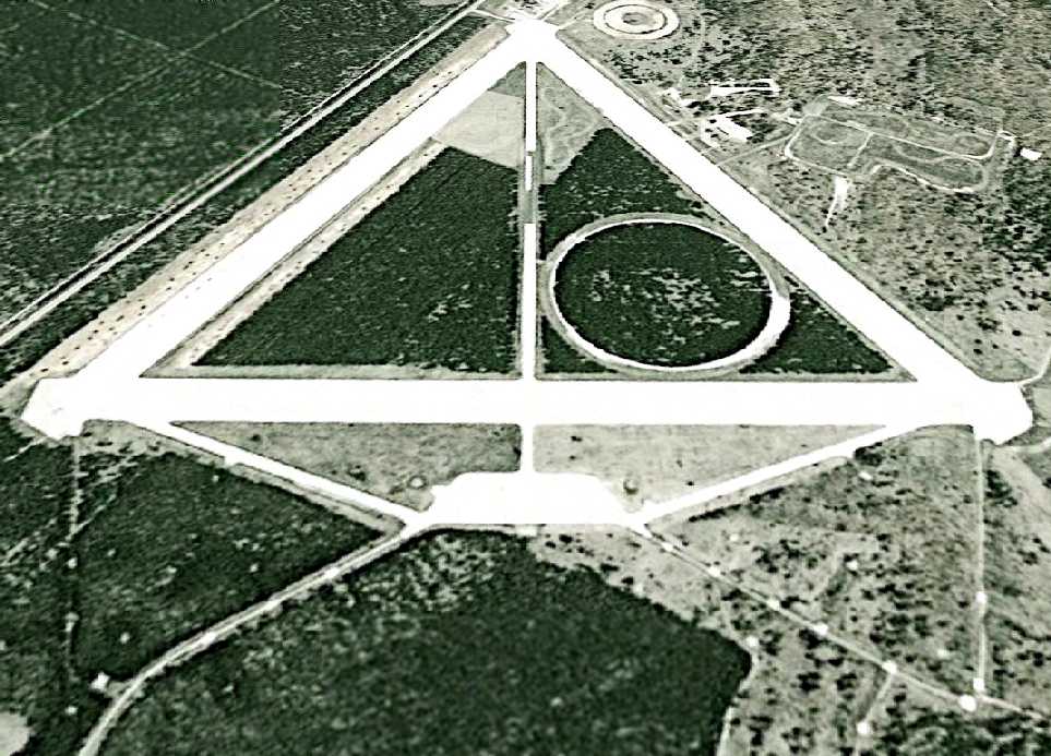
An 8/15/09 aerial view looking northeast showed the 3 former Raco runways, the numerous former Skysweeper AAA pads,
and the test track constructed over the former BOMARC missile site.
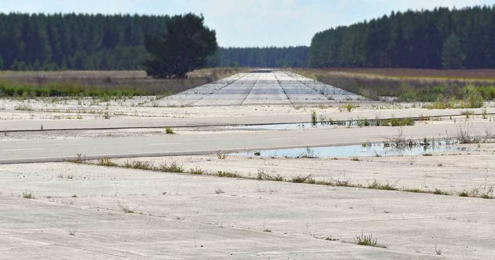
A 2012 photo by Scott Murdock looking along a former Raco runway.
Thanks to Tim Tyler for contributing information about Raco.
____________________________________________________
Since this site was first put on the web in 1999, its popularity has grown tremendously.
That has caused it to often exceed bandwidth limitations
set by the company which I pay to host it on the web.
If the total quantity of material on this site is to continue to grow,
it will require ever-increasing funding to pay its expenses.
Therefore, I request financial contributions from site visitors,
to help defray the increasing costs of the site
and ensure that it continues to be available & to grow.
What would you pay for a good aviation magazine, or a good aviation book?
Please consider a donation of an equivalent amount, at the least.
This site is not supported by commercial advertising –
it is purely supported by donations.
If you enjoy the site, and would like to make a financial contribution,
you
may use a credit card via
![]() ,
using one of 2 methods:
,
using one of 2 methods:
To make a one-time donation of an amount of your choice:
Or you can sign up for a $10 monthly subscription to help support the site on an ongoing basis:
Or if you prefer to contact me directly concerning a contribution (for a mailing address to send a check),
please contact me at: paulandterryfreeman@gmail.com
If you enjoy this web site, please support it with a financial contribution.
please contact me at: paulandterryfreeman@gmail.com
If you enjoy this web site, please support it with a financial contribution.
____________________________________________________
This site covers airfields in all 50 states.