
Abandoned & Little-Known Airfields:
Southeastern Missouri
© 2002, © 2016 by Paul Freeman. Revised 11/12/16.
This site covers airfields in all 50 states: Click here for the site's main menu.
The MO pages of this website are sponsored by the Missouri Aviation Historical Society:
____________________________________________________
Please consider a financial contribution to support the continued growth & operation of this site.
Arrowhead Airport (revised 11/12/14) - Cooter Aux AAF #4 (revised 12/24/10)
Lobmaster Field / Lobmaster Sky Ranch (revised 4/27/14) - Weiss Airport (revised 2/14/12) - Wentzville Airport (revised 11/12/16)
____________________________________________________
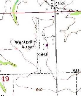
Wentzville Airport (MO50), Wentzville, MO
38.821, -90.834 (Northwest of St. Louis, MO)
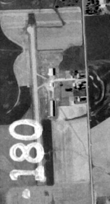
Wentzville Airport, as depicted on the 5/1/74 USGS aerial photo.
Wentzville Airport was apparently built at some point between 1969-71,
as it was not depicted on the 1969 USGS topo map.
The earliest reference to the field which has been located was in the 1971 Flight Guide (according to Chris Kennedy),
which described Wentzville in the "low use airports" section as having a single 2,400' unpaved Runway 17/35.
Rick Butterfield recalled, “My father Rick Butterfield Sr. (& business partner Jerry Collinson) ran the Wentzville Airport
in the early 1970s for the Sachs family under the name Aire Wentzville.
A fella by the name of Roederer was the Flight Instructor.”
The earliest depiction which has been located of the Wentzville Airport was on a 5/1/74 USGS aerial photo.
It depicted Wentzville as having a single paved north/south runway,
with a few small buildings on the east side of the field.
Tim Haake recalled of Wentzville Airport, “It was my FBO after I purchased my first airplane in the late 1970s.
Wentzville Airport was owned by a large farming & flying family of several generations.
It was looked at in the 1970s as being a possible new location for a county airport
but was deemed 'land-locked' for the purposes of providing larger & extra runways.
I knew the owners/family & the mechanic well.
They had fuel, hard surface, grass strip for glider instruction, and lighting.
They had a full FBO & nice hangars plus J&C Aircraft which did annuals
and had applied for repair station authorization to do engines.”
The runway at Wentzville had apparently been paved within the next decade,
as the 1982 AOPA Airport Directory (courtesy of Ed Drury)
described the field as having a single 2,400' asphalt Runway 18/36.
The operators were listed as Wentzville Flying Service and J & C Aircraft Repair.
The 1982 USGS topo map depicted the Wentzville Airport as having a single unpaved runway,
with a few small buildings on the east side of the field.
According to Andy Kendig, Wentzville Airport had for him "a personal attachment.
An early (and popular), short, round-robin solo was Spirit of St. Louis - Wentzville - Washington – return."

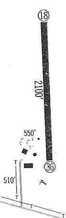
A 5/6/83 airport diagram (courtesy of John Kielhofer) depicted Wentzville Airport
as having a single 2,395' paved Runway 18/36, with a ramp & 4 small buildings on the east side.
Joe St.Clair recalled of Wentzville Airport, “I learned to fly there in 1988 where I obtained my private pilot’s license.
It also was home to Midwest Soaring owned by Bob Eaton.
I towed for him in the early 1990s.
It was my first aviation job after obtaining my Commercial Pilot’s license.”

The last photo which has been located of Wentzville Airport was a 1995 USGS aerial view looking southwest.
The airport was well-used, as a total of at least 13 planes were visible on the Wentzville Airport property.
A row of T-hangars & several other airport buildings sat to the east of the runway.
According to Tim Haake, “They [Wentzville Airport's owners ] were getting pressured by the county to sell
because GM was looking for a site to build a new auto plant. Money prevailed.
When the county started pressure J&C saw the light & moved their repair station to WVA.
The Sachs (owners) took the cash & ran.”
Joe St.Clair recalled, “It was a quaint little field that meet the ultimate demise of greed.
It was privately owned & publicly used.
The family that owned it was the Sach’s family (Bert, Suzanne, Dorothy, Maury and Mike).
It was for sale for roughly 10 years & finally sold in 1997.
I last flew in there after it had closed in the spring of 1998.
The long-time instructor, Dale Hand (of Hand Air Service) died
and a flyover was planned for his burial at the nearby cemetery.
The Sachs opened it temporarily & allowed the involved planes to assemble there.”
Wentzville Airport was was no longer listed in the 1998 Airport/Facility Directory.
A 2002 aerial photo showed the Wentzville property had been completely redeveloped,
with not a trace remaining of the former airport.
Several roads & buildings had been built over the airport property.

A 2016 aerial view looking southwest shows the Wentzville Airport property was completely unrecognizable as having ever been an airport.
The site of Wentzville Airport is located west of the intersection of Edinger Road & Sachs Lane.
The huge General Motors Assembly Plant is located directly across Edinger Road.
Thanks to Andy Kendig for pointing out this former airfield.
____________________________________________________
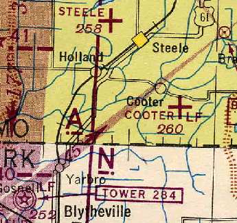
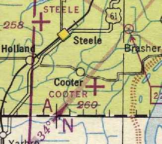
Cooter Auxiliary Army Airfield #4, Cooter, MO
36.03, -89.78 (North of Memphis, TN)
A 7/6/43 aerial view looking north from the 1945 AAF Airfield Directory (courtesy of Scott Murdock)
depicted “Blytheville AAF Auxiliary #5 (Cooter Field)” as having 2 paved runways.
This airfield was evidently built at some point between 1937-43, as no airfield was listed at the location
in The Airport Directory Company's 1937 Airports Directory (courtesy of Bob Rambo).
The earliest depiction which has been located of this airfield
a 7/6/43 aerial view from the 1945 AAF Airfield Directory (courtesy of Scott Murdock).
It depicted “Blytheville AAF Auxiliary #5 (Cooter Field)” as having 2 paved runways.
Cooter Aux AAF was used during WW2 as one of 4 satellite airfields under the control of Blytheville Army Airfield,
which conducted basic through advanced training for the 50,000 Pilot Training Program,
and also trained crews of troop carrier crews.
The April 1944 US Army/Navy Directory of Airfields (courtesy of Ken Mercer)
described "Cooter Aux, Army" as having a 4,000' hard-surfaced runway.
The earliest aeronautical chart depiction which has been located of Cooter Auxiliary Airfield
was on the 1944 Nashville Sectional Chart (courtesy of Chris Kennedy).
The 1945 AAF Airfield Directory (courtesy of Scott Murdock) described “Blytheville AAF Auxiliary #5 (Cooter Field)”
as a 699 acre irregularly-shaped property having 2 asphalt 4,000' runways, oriented north/south & northwest/southeast.
The field was not said to have any hangars,
and was described as being owned by the U.S. Government & operated by the Army Air Forces.
The date of closure of Cooter Aux AAF is unknown, but Blytheville AAF closed in 1945.
Cooter apparently remained open in some capacity for some period after WW2,
as it was still depicted as an Auxiliary Airfield
on the November 1946 Nashville Sectional Chart (courtesy of Chris Kennedy).
The Cooter airfield was definitely abandoned by 1953,
as it was not depicted at all on the 1953 Nashville Sectional Chart (courtesy of Chris Kennedy).
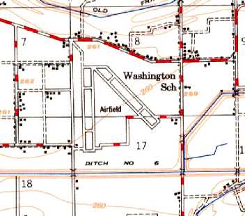
The 1955 USGS topo map depicted the 2 paved runways & parallel taxiways of the Cooter Auxiliary Field,
labeled simply as “Airfield”.
No buildings were depicted on the airfield.
Blytheville was reactivated as an Air Force Base from 1955-92,
but it is unlikely that the Cooter Auxiliary field was reused during that period,
as its runways would have been insufficient to operate jet aircraft.
It does not appear as if Cooter was ever reused for civil aviation,
as it was not listed among active airfields in the 1962 or 1982 AOPA Airport Directories,
and it was not depicted at all on later USGS topo maps.
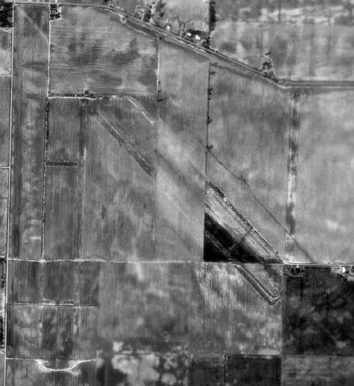
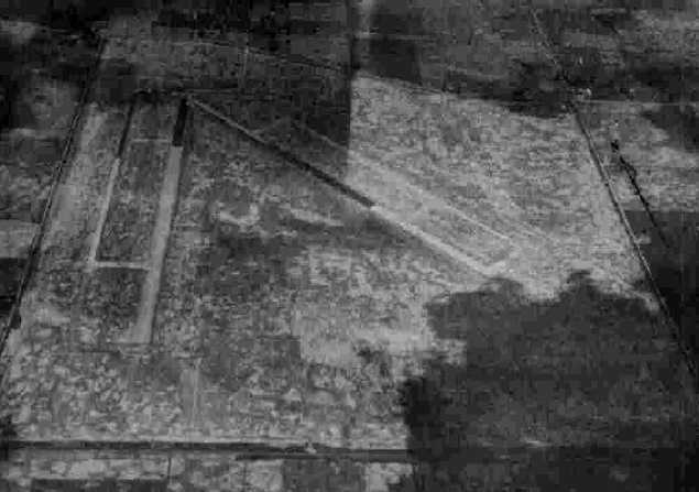
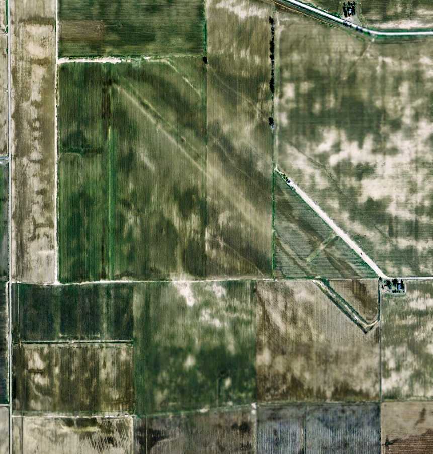
As seen in the 1996 USGS aerial photo, the site of the former airfield has been taken over by farming,
but the outline of 2 former runways (each with a parallel taxiway) are still recognizable.
It is not known if there were originally any buildings at the airfield site.
A 2006 aerial view showed the remains of the Cooter airfield remained unchanged from the 1996 photo.

A circa 2006-2010 aerial view showed a house which sits over the southeastern end of the NW/SE Cooter runway.
A 2007 aerial view of the site of the Cooter Airfield showed it virtually unchanged from the 1996 photo,
with the outline of the 2 runways & taxiways still recognizable.
The site of Cooter Auxiliary AAF is located southeast of the intersection of State Highway E & Route 567,
two miles southeast of Cooter, MO.
Thanks to Andy Kendig for pointing out this former airfield.
____________________________________________________
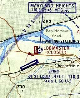
Lobmaster Field / Lobmaster Sky Ranch, Chesterfield, MO
38.68, -90.63 (West of St. Louis, MO)
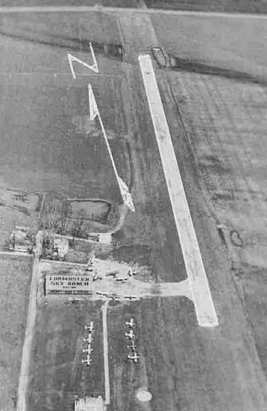
An aerial view looking north at the "Lobmaster Sky Ranch", from a circa 1957-61 MO Airport Directory (courtesy of Chris Kennedy).
A total of 16 light aircraft were visible parked on the southwest side of the field.
Lobmaster Field was not yet depicted on a 1952 Missouri Aeronautical Chart (according to David Brooks).
According to Brad Cleghorn, Lobmaster Field started operations in May 1959.
The earliest directory reference to Lobmaster Field which has been located
was in a circa 1957-61 MO Airport Directory (courtesy of Chris Kennedy).
It described the field as having a single 2,000' hard-surface Runway 17/35.
A taxiway led to a ramp on the southwest side of the runway,
with a single hangar which had "Lobmaster Sky Ranch" painted on the roof.
The field was said to offer fuel, hangar storage, tiedowns, and repairs.
The 1960 Jeppesen Airway Manual (courtesy of Chris Kennedy)
depicted Lobmaster as having a single 2,100' paved Runway 18/36,
with a few small buildings on the southwest side of the runway.
"[Dave] Lobmaster started the banner-tow advertising flights in 1960,
and hired Harold Baker to get the banners off the ground",
according to a 1966 St. Louis Post Dispatch article (according to Brad Cleghorn).
“[Wayne] Baker came into command of Lobmaster & Baker Aeronautics by a series of fatal air accidents.
His older brother, Harold Baker, took over the field and the aerial banner advertising flights
after Dave Lobmaster died in a charter flight crash.”
The 1962 AOPA Airport Directory described Lobmaster as having a single 2,100' hard-surfaced Runway 18/36,
and said the field offered hangars, tiedowns, fuel, charter, and minor repairs.
The operator was listed as Samuel Lobmaster.
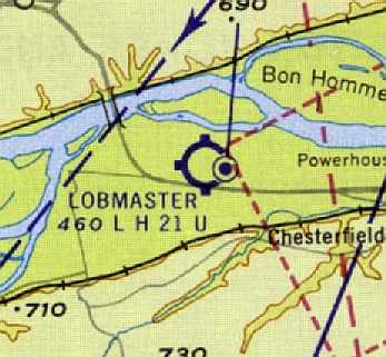
The January 1963 St. Louis Local Aeronautical Chart (courtesy of David Brooks)
depicted Lobmaster as having a 2,100' hard-surface runway.
The Maryland Heights VORTAC navigational beacon was depicted immediately adjacent to the east side of Lobmaster.
A 1964 aerial view by Brad Cleghorn looking west at Lobmaster Field.
Brad observed, “You can see the SNJ-4 along with several of the Cubs & Tri-Pacers that Harold Baker owned.”
The Greater St. Louis Parachute Club was reported to have operated at Lobmaster Field in the 1960s,
after having moved from Weiss Airport.
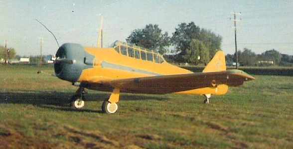
A 1965 photo by Jim Hoisington of Harold Baker's SNJ-4 at Lobmaster Field.
Jim recalled, “Wayne & I got that plane started one day (I pulled the prop standing on a step stool)
and he was attempting a take off when he got a flashing red light from the tower at the new Spirit Airport across the street.
It never did fly, it was taken apart & trucked out when he sold it.
I remember he had the parachutes hanging in his house.
His house was about a hundred feet from the hangar.”
Jim Hoisington recalled, “Lobmaster Field... I worked there in 1965 for Wayne Baker.
He was a fine gentleman who enjoyed classical music.
He hired me at 50 cents/hour to cut grass, maintain the runway, refuel airplanes & do miscellaneous jobs around the airport.
I was 16 & loved that job.
They offered air plane rides over the St. Louis Arch (under construction at the time) for $5/person,
and as most passengers were boyfriend & girlfriend they would sit together in the back of the plane
and I would hop a ride as copilot for free.
Wayne let me attend the ground school classes for free
but making 50 cents/hour didn't give me much money for air time.”
Jim continued, “I only worked there that summer in 1965
and left because Wayne could not afford to pay me anymore,
I remember working for free for a little while, maybe a week or two.
Spirit put him out of business by diverting the traffic to them as we did not have a radio tower.”
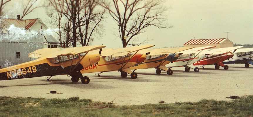
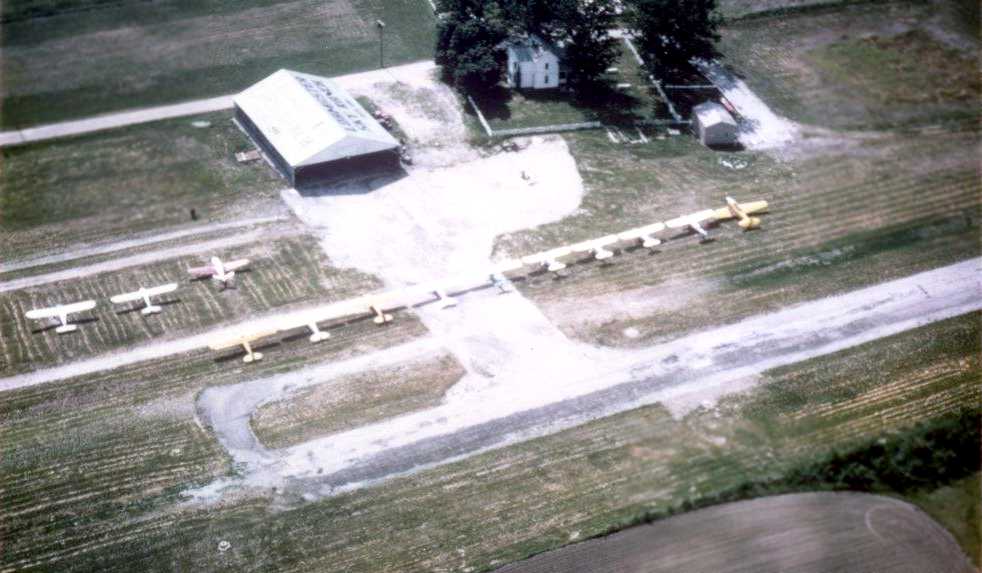
A 1966-67 photo of a multicolored lineup of Piper Cubs (4 PA-11s, a PA-18/90, and a PA-12)
belonging to Harold & Wayne Baker at Lobmaster Field (courtesy of Brad Cleghorn).
According to Brad Cleghorn, “The PA-12 (far right) was lost when the T-hangar on the far left in the photo caught fire.”
Brad Cleghorn recalled, “My uncle, Harold Baker, was the airport manager & a flight instructor at Lobmaster Field during the 1960s.
Unfortunately Uncle Harold died in a plane crash before I was born,
but his younger brother Wayne was also active at Lobmaster.”
David Brooks recalled, "I worked for McDonnell Douglas in St. Louis from 1968-83.
The strip was located off of US 40 before you got to the Missouri River bridge.
I clearly remember it was there because of the navigational VORTAC located next to it.
The runway looked like asphalt to me & not in very good condition.
Looked like it was only about 40-50' wide.
A number of those airfields in that general region (Arrowhead, Creve Coeur, etc.)
were built done on the flood plain of the Missouri river
so every time it flooded, those fields generally went underwater for a while."
Buz Heuchan recalled “Lobmaster Field where I learned to fly.
I soloed a Colt (N5467Z) there 9/29/66 with Dale Hand as my CFI.
The day I soloed, I recall a plane had crashed at the north end of the strip & was still there for my 1st solo.
I have many memories of this place.
The strip was in terrible shape, as well as the buildings.
To help with my instruction, I installed a PA system & an intercom system
between the small office & the hangar as there was about 100 yards between the two.”

The 1968 USGS topo map depicted Lobmaster Airport as having a single unpaved northwest/southeast runway with a few small buildings on the southwest side.
Lobmaster Field was still open in 1968,
but the much larger Spirit of St. Louis Airport had been built immediately adjacent to Lobmaster (across Route 40)
at some point between 1963-68,
and much of Lobmaster's aircraft traffic had moved over to Spirit of St. Louis Airport.
David Brooks recalled, "My recollection is about 3-5 small single engine aircraft
and an old derelict [Harold Baker's SNJ-4] in bad shape off to the side were there.
One T-hangar was there & a couple of small out-buildings."
According to Brad Cleghorn, “The Greater St. Louis Parachute Club operated there until 1968,
and my Uncle Wayne also noted that the club crashed one his airplanes, a Cessna 182 (N7272E).”
Lobmaster Field ceased operations in October 1968 (according to Brad Cleghorn).
Thus it lasted not even a decade.
Lobmaster Field was apparently closed at some point prior to 1971,
as the May 1971 St. Louis Sectional Chart (courtesy of Robert Brown)
continued to depict Lobmaster as having a single north/south paved runway,
but the field was labeled "Closed".
The Maryland Heights VORTAC was still in operation at this point, though.
In contrast to the 1971 aeronautical chart, a 1971 aerial photo showed that all traces of the former runway had been removed.
The VOR building still remained intact, though.
David Brooks recalled, "Then they decided to widen & move US 40 highway from Creve Coeur
to the old US 40 bridge to accommodate growth.
The highway eliminated Lobmaster & the VORTAC.
My recollection is that the highway widening occurred in the mid-1970s."
According to Andy Kendig, "I recall a VOR building being present for many years after the Maryland Heights VOR was moved
and to the best of my recollection it was simply converted to a concession building when the sports park was built."
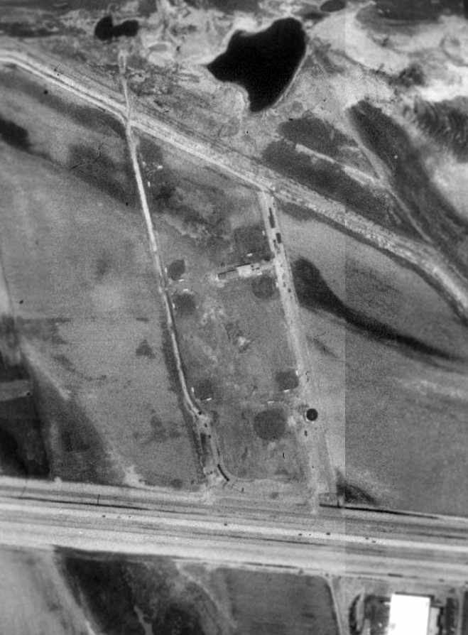
In the above 1996 USGS aerial photo, not a trace was still perceptible of the former runway,
with several baseball diamonds having been built over the former airfield.
However, it appears as if the VOR building still remains - the dark round building just north of the highway.
The site of Lobmaster Field is located north of the intersection of Interstate 64 & Spirit of St. Louis Airport Boulevard.
____________________________________________________
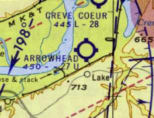
Arrowhead Airport (02K), St Louis, MO
38.7, -90.52 (Southwest of Lambert St Louis International Airport, MO)
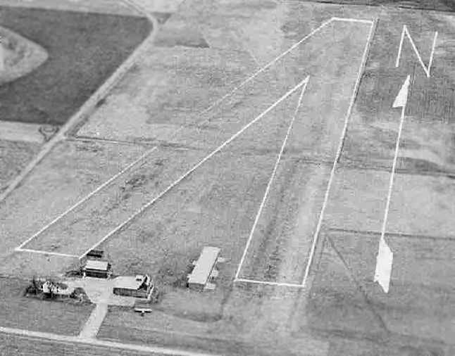
An aerial view looking northwest at Arrowhead Airport, from a circa 1957-61 MO Airport Directory (courtesy of Chris Kennedy).
This small general aviation airport was evidently established at some point between 1954-61,
as it was not yet depicted on the 1954 USGS topo map.
The earliest depiction of Arrowhead which has been located
was in a circa 1957-61 MO Airport Directory (courtesy of Chris Kennedy).
It described Arrowhead as having two 2,750' turf runways: 3/21 & 1/19.
A few small hangars were located in between the 2 runways on the south side of the field,
which was said to offer fuel, hangars, tiedowns, and minor repairs.
The 1962 AOPA Airport Directory described Arrowhead as having a single 2,000' bituminous Runway 4/22.
The 1963 St. Louis Local Aeronautical Chart (courtesy of David Brooks)
depicted Arrowhead as having a 2,700' unpaved runway.
Leigh Hettick recalled, "I learned to fly in 1966 at Arrowhead Airport.
The airport was owned by folks named Heaton who were in the real estate business.
They had a fleet of 5 new Alon Aircoupes.
Several of us who went to college together in New York & who were working at McDonnell Aircraft took our training there.
After we soloed, we expanded their training syllabus several times to include formation flying.
They ran a relaxed & friendly little operation."

The 1978 USGS topo map depicted Arrowhead Airport as having 2 unpaved runways.
The May 1971 St. Louis Sectional Chart (courtesy of Robert Brown)
depicted Arrowhead as having a single 2,400' paved runway.
A 1971 aerial photo depicted Arrowhead as having a single paved runway,
with a large number of aircraft visible parked outside.
The July 1973 Kansas City Sectional Chart (courtesy of Chris Kennedy)
continued to depict Arrowhead as having a 2,400' paved runway.
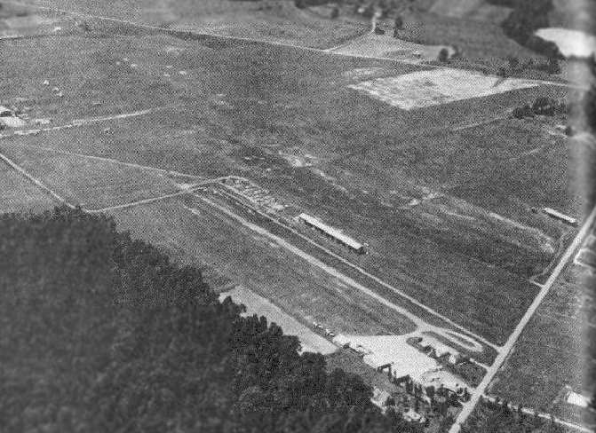
A circa 1975-78 photo by Albert Stix of Arrowhead Airport, “taken from the 'tower' built into the roof of the main office, a converted barn actually.”
Chris recalled, "I learned to fly in the St Louis area in the mid 1970s.
One interesting note on the former Arrowhead airport -
It was a hotbed of warbirds before everyone had a warbird.
I rented a [Cessna] 150 based at Lambert as a student
(try to imagine student pilots based out of major hub airports!).
I did most of my touch & goes at Arrowhead.
I remember a T-6, 2 T-28 and a Bearcat at the airport.
Also at one time there was a cross grass runway that attracted a lot of taildraggers."
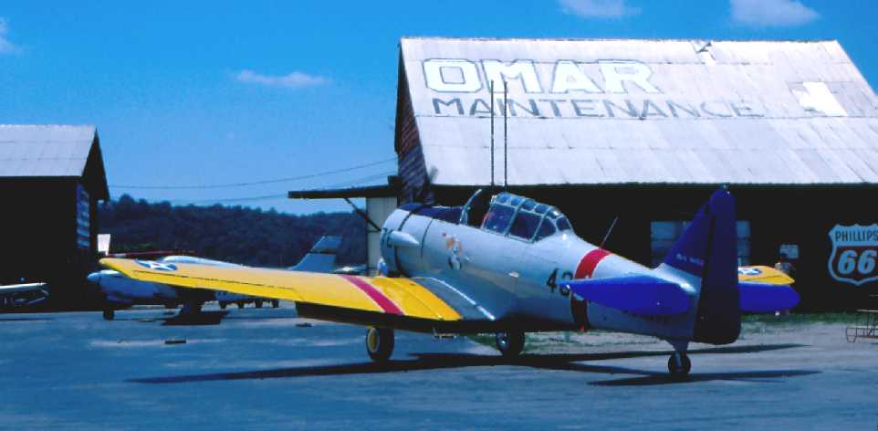
A circa 1979-80 photo by Albert Stix “of my father’s SNJ-5 arriving [ at Arrowhead] from Rockford, Illinois. That’s Mark Clark delivering the plane.
Omar was owned by Gene O’Connell. He was a long time A&P instructor at a local tech school.”
Arrowhead's runway was lengthened somewhat by 1982,
as the 1982 AOPA Airport Directory (courtesy of Ed Drury)
described the field as having a 2,880' asphalt Runway 2/20 & a 2,700' turf Runway 15/33.
It listed the operators as Bryan Management Corp., Eagle Air,
St. Louis Helicopter Airways, and Omar Aviation Maint.
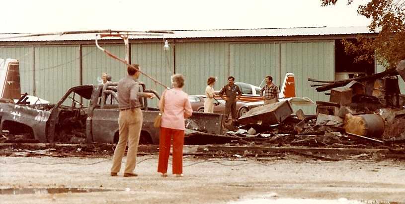
An October 1983 photo by Albert Stix of damage at Arrowhead Airport after a fire, “taken the morning after the fire.
The fire pretty much ended any chance of Arrowhead having a future.”
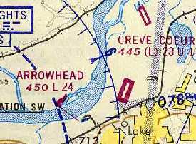
Arrowhead was almost immediately adjacent to Creve Cour Airport.
The 2 traffic patterns almost conflicted with each other.
Arrowhead probably had the better runway - but oddly Creve Cour survived instead.
Paul Swarthout recalled, “The flood of 1993 flooded the airport with more than 10 feet of water.
The flood waters severely damaged the runway & the buildings on the property.”
Arrowhead Airport closed shortly after the 1993 flood.
According to Paul Swarthout, “I suspect that the airport closed because they didn't have the funds to repair the airport buildings & runway.”
Albert Stix recalled, “In the long run, Arrowhead was doomed.
Not because of the new bridge, it actually wound up being built alongside Creve Coeur Airport’s property and missed Arrowhead by several miles.
It was doomed because of Arrowhead’s proximity to the St. Louis County Water Works
and the residential neighborhoods along the bluff just South of the airport in Chesterfield, Missouri.
The flood of 1986 did not help either airport but The Great Flood Of 1993 ended Arrowhead for good
when the City of Maryland Heights stopped it from re-opening by not re-issuing its Conditional Use Permit.”
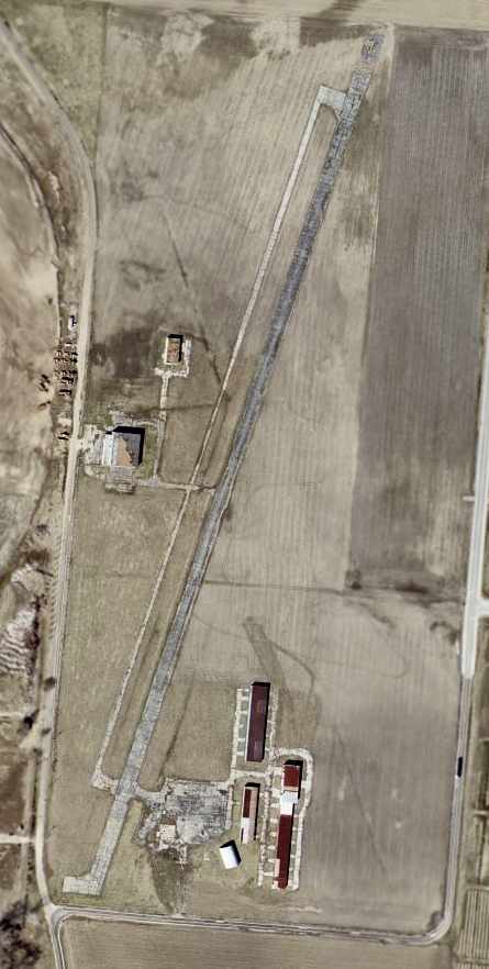
The 1996 USGS aerial photo showed the single paved runway, as well as a parallel taxiway & a few small hangars,
and the former grass runway was still discernible as well.
USGS aerial photo 2002, after the field's closure.
According to Steve Collins, the current owner of the airport land
has been approached many times about allowing radio controlled model aircraft activities
and he has flatly refused every time.
The owner is holding on to the land for speculation purposes.
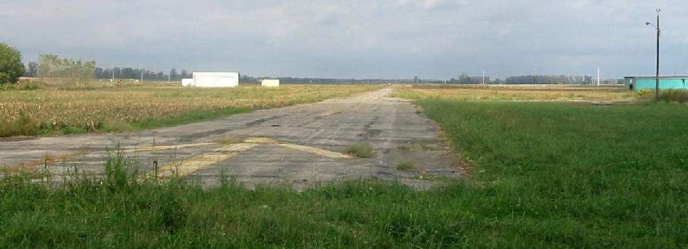
A 2002 photo by Gavin Haslett looking north along the former Arrowhead Airport Runway 2.
Gavin Haslett reported there was a sign advertising the property for lease.
A 2002 photo by Gavin Haslett of former hangars at Arrowhead Airport.
Paul Swarthout reported in 2005, “Today, the damaged buildings remain standing,
a farmer grows corn on one end of the land, and several baseball diamonds have popped up since the spring of 2005.
Part of the paved runway is being used as a private road for access to the ball fields.”
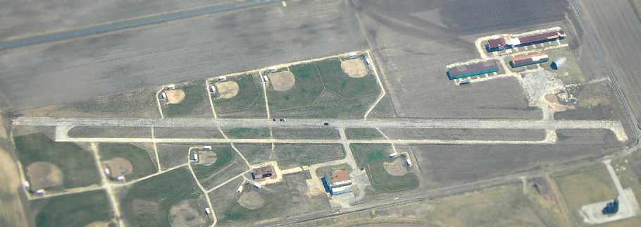
A March 2006 aerial photo by Andy Kendig looking east at the former Arrowhead Airport
shows the field remains almost completely intact, including the runway, taxiway, and hangars,
even though ball fields have been added on either side of the runway.
Arrowhead Airport is located northeast of the intersection of River Valley Drive & Hog Hollow Road.
Thanks to Andy Kendig for pointing out the closure of this airfield.
____________________________________________________
Weiss Airport (3WE), St Louis, MO
38.54, -90.45 (Southwest of Downtown St. Louis, MO)
An undated aerial view looking southwest at Weiss Airport (foreground)
& the adjacent former Sylvan Beach Airport (grass area in the background)
from the 1947 MO Airport Directory (courtesy of Stephen Mahaley).
This general aviation airport was evidently established at some point between 1945-47,
as it was not yet listed among active airfields in the 1945 AAF Airfield Directory (courtesy of Scott Murdock)
nor depicted on the September 1946 Wabash River World Aeronautical Chart.
The earliest reference which has been located to Weiss Airport
was in the 1947 MO Airport Directory (courtesy of Stephen Mahaley).
It listed the owner as Harley Weiss.
Weiss was described as consisting of a single north/south 1,500' turf strip.
The directory noted that the landing facilities of the adjacent Sylvan Beach Airport were also used.
Sylvan Beach was adjacent to the west,
and had 3 turf runways (with the longest being a northeast/southwest 5,400' strip).
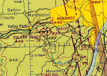
Weiss, Sylvan Beach, and Meramac Airports, all depicted in very close proximity
on the 1948 Kansas City Sectional Chart (courtesy of Chris Kennedy).
Weiss was described as having a 1,300' unpaved runway - mighty short!
Sharon Irish recalled, “My Father, Glenn Irish, owned his own business at Weiss Airport from June 1948 - November 1949.
It was named Kirkwood Aero Repair Service.
I was 4 years old at the time & went flying every afternoon with my Dad when he tested his repair for the day.
We lived in a small house at the edge of the field.”
Keith Milton reported, "My father was Hugh Milton & started flying at Weiss in 1950
and began teaching around 1952 until the late 1960s when he had to stop due to health reasons.
There was also an east/west grass runway at Weiss
and next to the house was an in-ground swimming pool where I learned to swim when I was 4 years old
while my Mom sat & watched us kids & my dad gave flying lessons.
I also learned to fly there & really miss the old place."
The Greater St. Louis Parachute Club was formed in May of 1957 & was originally located at Weiss Airport.
It later moved to Lobmaster Field.
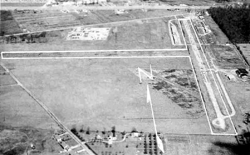
An aerial view looking north at Weiss Airport, from a circa 1957-61 MO Airport Directory (courtesy of Chris Kennedy).
The field was described as having a 3,000' hard-surface Runway 17/35 & a 2,200' turf Runway 8/26.
Hangars lined the northeast & northwest sides of Runway 17/35.
Bruce Trent recalled, “I attended electronics school at Scott AFB in 1958
and was a member of the Scott AFB Aero Club.
The club had a least one Aeronca Champ & 2 Beechcraft T-34s.
A while back I began trying to remember the name of the airfield where the planes were located.
I remembered the physical location of the airport in relation to downtown St. Louis
and [I have] become pretty sure it was Weiss.
In [the circa 1957-61 aerial view] you can see what looks like a really short runway(s)
just to the left (West) & at 45 degrees to the 17/36 paved runway.
This
was an active automotive drag strip in 1958.”
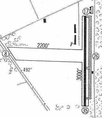
Weiss Airport was depicted in the 1960 Jeppesen Airway Manual (courtesy of Chris Kennedy)
as having a single 3,000 paved Runway 17/35 with a parallel taxiway on the east side,
as well as a 2,200' unpaved Runway 8/26.
Two rows of T-hangars were located on the northeast side of Runway 17/35,
as well as a few other small buildings on the northeast & southeast sides.
Weiss Airport was listed among active airports in the 1962 AOPA Airport Directory,
by which point the runway had been paved & extended to 3,200',
and the operator listed as Midwest Aviation.
Weiss Airport, as depicted on the May 1971 St. Louis Sectional Chart (courtesy of Robert Brown).
A 1971 aerial view shows that Weiss had a single paved north/south runway.
The crosswind grass runway had evidently been abandoned at some point between 1960-71,
as several new roads crossed over its former location.
The airfield was very well-used, with a large number parked on both the east & west sides of the paved runway.
The 1972 Flight Guide (according to Chris Kennedy) described Weiss as having a single 3,040' paved Runway 18/36.
Deborah King recalled, “I flew with my new husband out of Weiss Field.
We based our AA-1 Yankee at Weiss, starting in 1973.
It was a very active (and crowded) field then, with so many planes based there that taxiing was difficult.
I recall a real family atmosphere. The field was managed (owned?) by a fellow named Taylor.
Lot of good hangar flying back then, even when the real thing wasn't possible.”
The 1982 USGS topo map still appeared to depict Weiss Airport as having 2 perpendicular runways, although the east/west runway had ceased to exist more than a decade before.
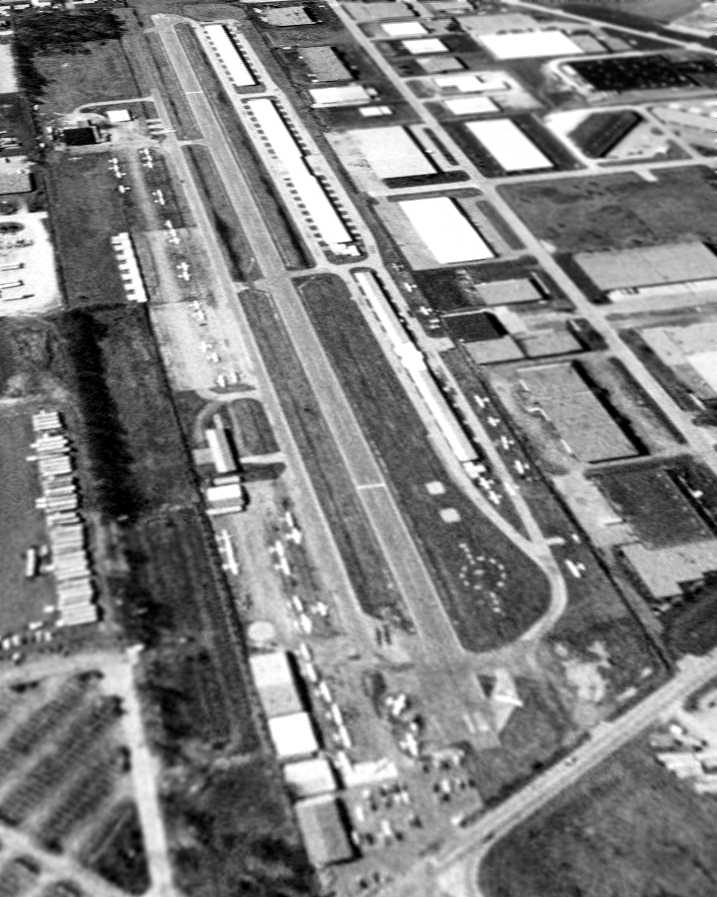
As seen in an April 8, 1990 USGS aerial photo looking southwest,
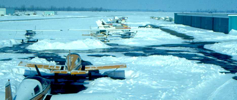
Weiss consisted of a single 3,000' paved runway & a large number of hangars.
Weiss was a very well-utilized airport, as over 47 aircraft were visible parked outdoors.
A local pilot recalled, “As you can see from the aerial photo, it was boxed in quite well by urban sprawl.
The public parking lot was CLOSE to the runway - it seemed like 20 or 30 ft
Until the mid-1980s there were a house & trees between the interstate & the access road
which was an obstruction & resulted in a 500' displaced threshold.
To the south, there was a fairly tall hill that looked scary to most 'flatland pilots',
but which was not really a factor.
Most folks turned base leg between the hill & the runway.”
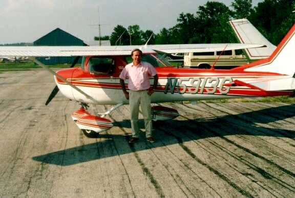
A 1992 photo of Paul Schlipp in front of his Cessna 150 at Weiss Airport.
Weiss was a vital airport - during the flood of 1993, the Spirit of St. Louis Airport
(a state of the art, 2-runway, reliever airport) flooded & many of the aircraft went to Weiss
& the FAA established a temporary control tower there.
You would think this might have established Weiss as a key contingency to the St. Louis area.
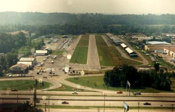
The last photo which has been located showing Weiss Airport while still open was a 1994 aerial view by Paul Schlipp (courtesy of Andy Kendig),
looking south while on final approach for Runway 18.
Karl Reinhardt recalled, “I believe that I am the last person to do his 1st solo at Weiss.
I did my first solo flights at Weiss on May 3, 1994.
I did some more on May 4, 1994.
The FBO's airplanes were flown to Spirit of Saint Louis May 5, 1994.
I remember the strip as 3,010' x 48' asphalt & pretty smooth.
The hill at the south end had a house up on the top right in line with the runway.
The traffic pattern was right traffic for Runway 36 & left traffic for Runway 18.
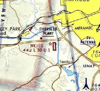
I believe that this was left over from the days of the other airport that was where the Chrysler plant was on the north side of I-44.
The 'standard' traffic pattern had the southwest corner cut off to miss the hill.
We did a couple of 45 degree turns instead of the normal 90 degree turn for the southwest corner.
They must have moved the house that was at the north end of the runway,
but the tree line was still there in 1994.
Weiss was a great training airport,
because we got to just learn to fly without a lot of traffic & we did not have to worry about a tower.
After we moved to Spirit, we learned to work with the tower & use the bigger runways & the extra exits to the taxiways.”
In 1994, the community markedly raised the property taxes & the airport was forced to close.
The FBO moved to Spirit of St. Louis Airport, but then closed after few years.
This airport closure is a very sore spot among local St Louis pilots.
It was the only airport convenient to the Southwest side of St. Louis.
It is about a 30 minute drive from Spirit of St. Louis Airport to the Southwest part of town.
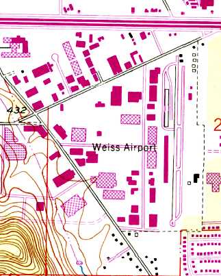
By 1996, a large industrial building was built over the center of the former airport,
and numerous other buildings covered the entire property,
with no trace remaining at all of the former airport.
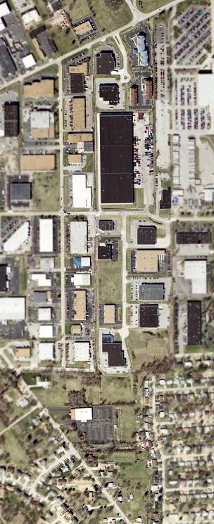
A 2002 USGS aerial photo of the site of Weiss Airport,
sadly heavily redeveloped & no longer even recognizable as a former airport.
Thanks to Andy Kendig for providing information about Weiss.
____________________________________________________
Since this site was first put on the web in 1999, its popularity has grown tremendously.
That has caused it to often exceed bandwidth limitations
set by the company which I pay to host it on the web.
If the total quantity of material on this site is to continue to grow,
it will require ever-increasing funding to pay its expenses.
Therefore, I request financial contributions from site visitors,
to help defray the increasing costs of the site
and ensure that it continues to be available & to grow.
What would you pay for a good aviation magazine, or a good aviation book?
Please consider a donation of an equivalent amount, at the least.
This site is not supported by commercial advertising –
it is purely supported by donations.
If you enjoy the site, and would like to make a financial contribution,
you
may use a credit card via
![]() ,
using one of 2 methods:
,
using one of 2 methods:
To make a one-time donation of an amount of your choice:
Or you can sign up for a $10 monthly subscription to help support the site on an ongoing basis:
Or if you prefer to contact me directly concerning a contribution (for a mailing address to send a check),
please contact me at: paulandterryfreeman@gmail.com
If you enjoy this web site, please support it with a financial contribution.
please contact me at: paulandterryfreeman@gmail.com
If you enjoy this web site, please support it with a financial contribution.
Or if you prefer to contact me directly concerning a contribution (for a mailing address to send a check),
please contact me at: paulandterryfreeman@gmail.com
If you enjoy this web site, please support it with a financial contribution.
____________________________________________________
This site covers airfields in all 50 states.