Abandoned & Little-Known Airfields:
Ohio: Southern Cleveland area
© 2002, © 2016 by Paul Freeman. Revised 8/13/16.
This site covers airfields in all 50 states: Click here for the site's main menu.
____________________________________________________
Please consider a financial contribution to support the continued growth & operation of this site.
Brooklyn Airport (revised 11/22/14) - Chagrin Falls Airport (revised 8/13/16) - Forepaugh Airport / Four Points Airport (added 3/1/15)
Ingalls Field (revised 5/2/15) - Miller Field (revised 2/10/16) - Sky Haven Airport (original location) / Welcome Airport (revised 2/10/16)
Sky Haven Airport (2nd location) (revised 2/10/16) - Strongsville Airpark (revised 2/10/16)
____________________________________________________
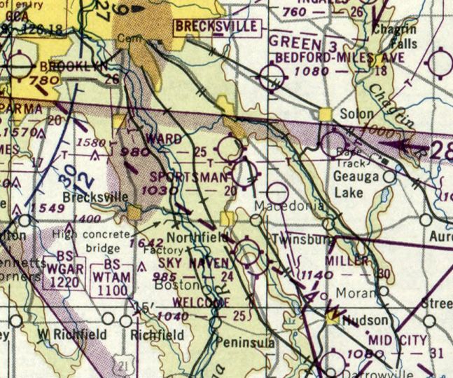
41.338, -81.492 (Southeast of Cleveland, OH)
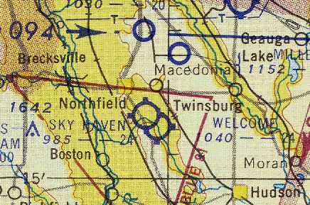
Miller Field, as depicted on the November 1950 Cleveland Sectional Chart.
This small private airfield was evidently established at some point between 1947-50,
as it was not yet depicted on the July 1947 Cleveland Sectional Chart.
The earliest depiction which has been located of Miller Field was on the November 1950 Cleveland Sectional Chart.
It depicted Miller as a private airfield with a 3,000' unpaved runway.
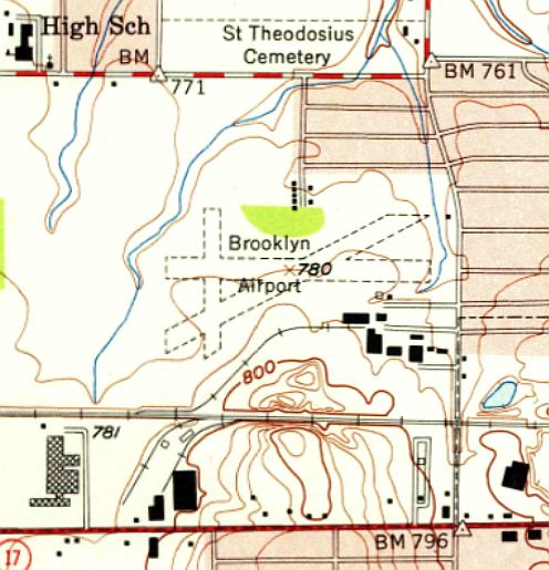
Miller Field was depicted as a private airfield on the 1950 USGS topo map.
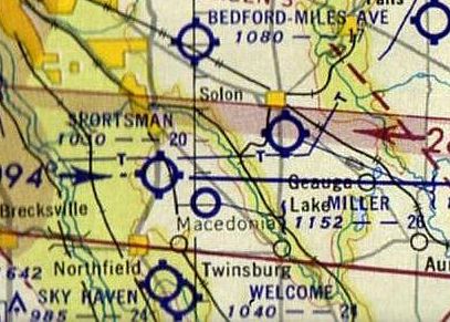
The last aeronautical chart depiction which has been located of Miller Field was on the 1953 Cleveland Sectional Chart.
It depicted Miller as a private field having a 2,800' unpaved runway.
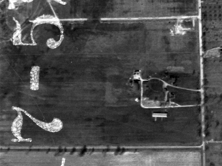
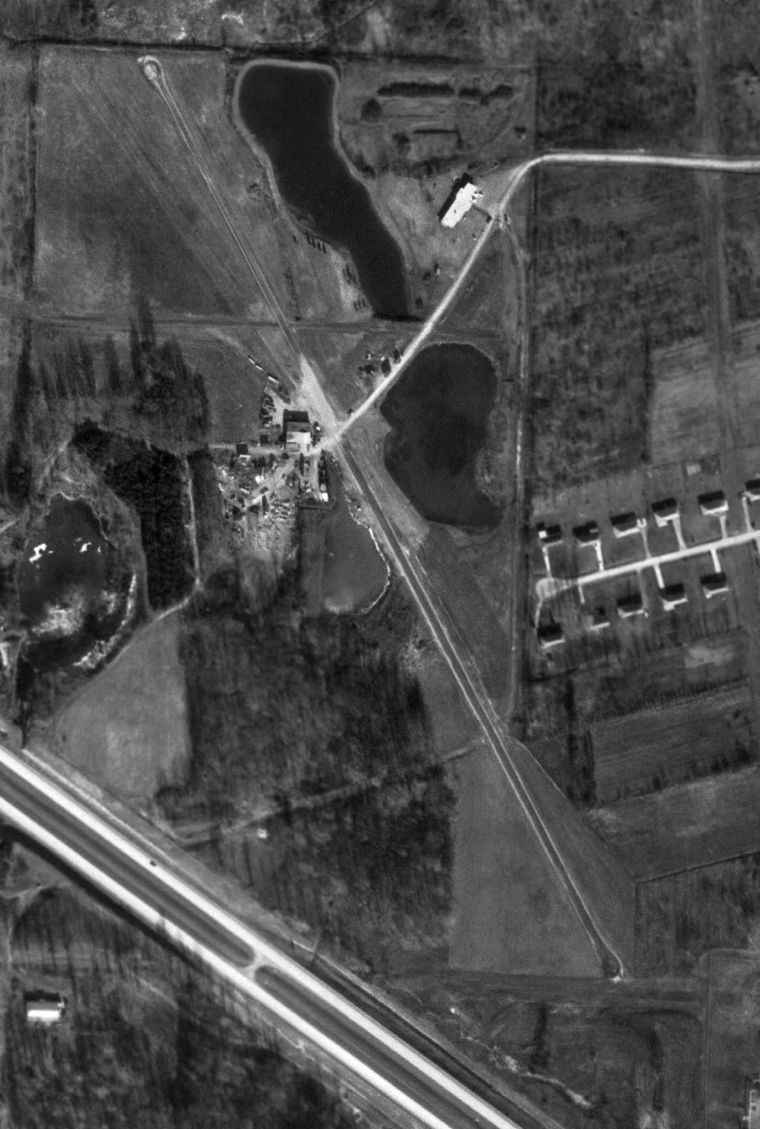
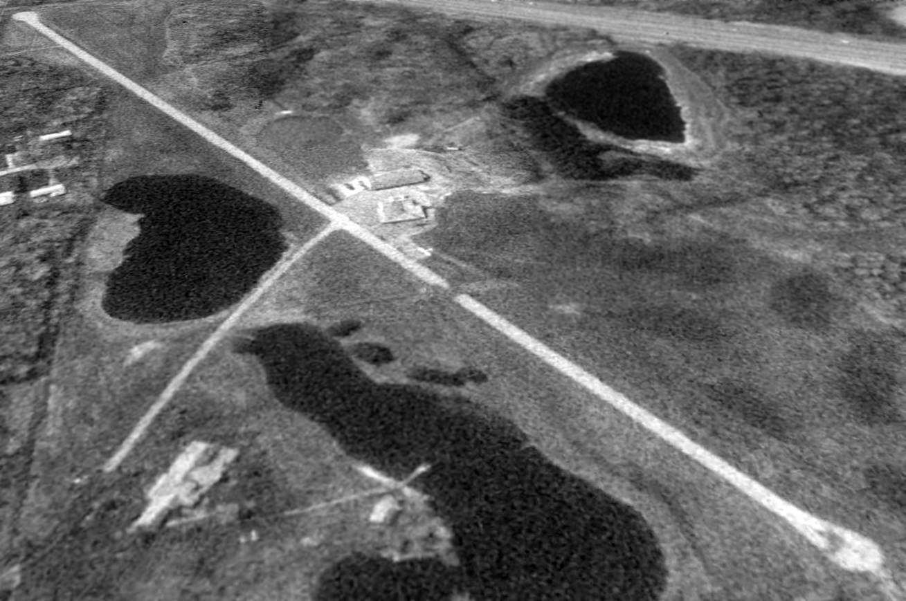
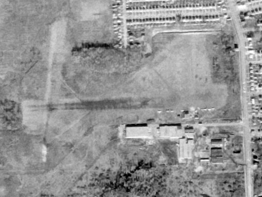
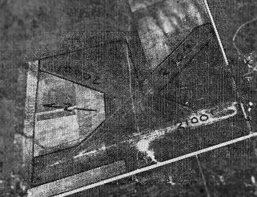
The only photo which has been located of Miller Field was a 4/17/52 USGS aerial view.
It depicted Miller as a rectangular property having a few small buildings on the east side,
but not aircraft were visible on the field.
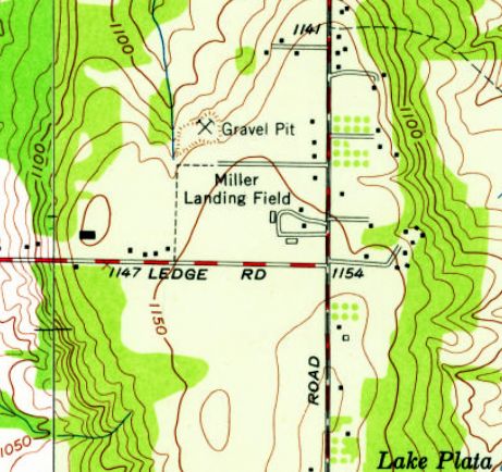
The last depiction which has been located of Miller Field was on the 1953 USGS topo map.
It depicted “Miller Landing Field” as a rectangular property having a few small buildings on the east side.
Miller Field was evidently closed at some point between 1953-63,
as it was no longer depicted on the 1963 USGS topo map.
Its closure may have been related to the constructed of Interstate 80 adjacent to the northeast side of the airfield property.
The airfield may also have been relocated to the north side of the Interstate, as Fore Points Airfield was established in the 1960s.
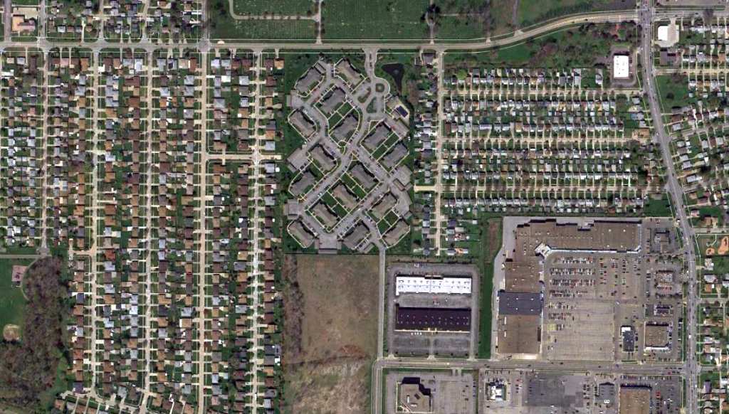
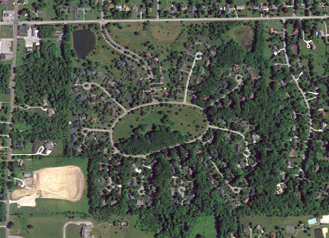
A 2014 aerial view showed no trace remaining of Miller Field.
As of 2015, street maps show that the housing development which covers the site of Miller Field
at least has street names which commemorate its previous life, such as Skyland Drive, Airlane Drive, and Cessna Drive.
____________________________________________________
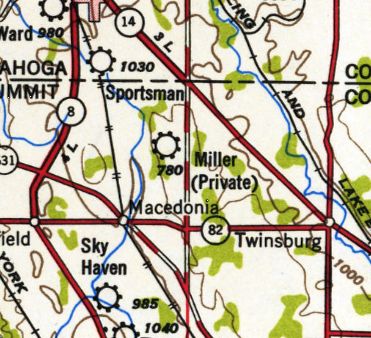
Forepaugh Airport / Four Points Airport, Macedonia, OH
41.347, -81.495 (Southeast of Cleveland, OH)

Four Points Airport, as depicted on the 1963 USGS topo map.
This private airfield may have been the replacement for Miller Field, which was located across Interstate 80 to the south.
The earliest depiction which has been located of Four Points Airport was on the 1963 USGS topo map,
which depicted it as having an unpaved northwest/southeast runway,
and a much shorter & narrower unpaved east/west runway.
The earliest photo which has been located of Four Points Airport was a 12/17/67 USGS aerial view.
It depicted Miller as a private field having a 2,800' unpaved runway.

The airport may have been briefly renamed “Forepaugh”, as that is how it was depicted on the 1968 Cleveland Sectional Chart (courtesy of Richard Finley).
It depicted Forepaugh as a private airfield with a 3,000' paved northwest/southeast runway.

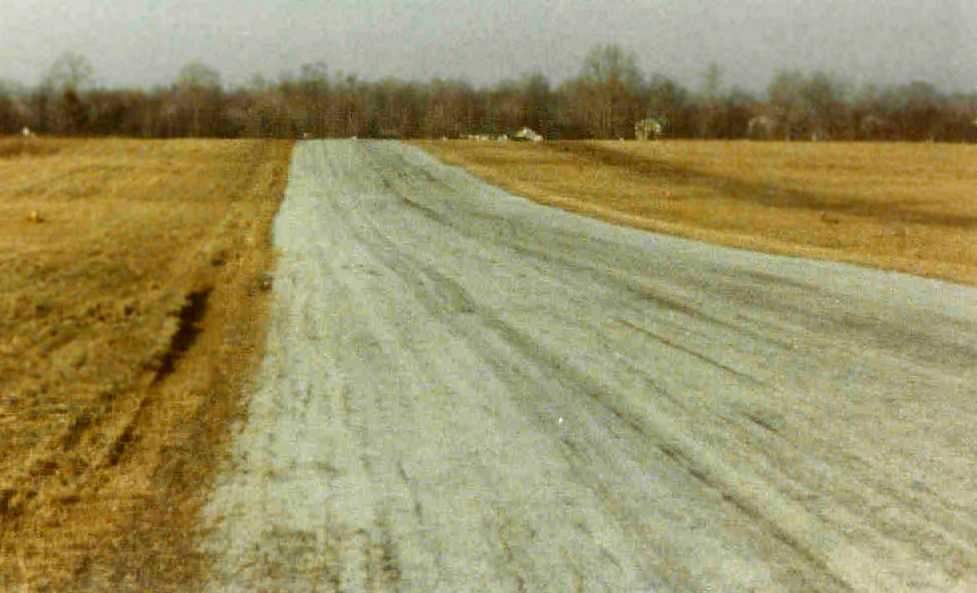
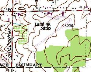
The 1994 USGS topo map depicted 2 unpaved runways, but labeled simply as “Landing Strip”,
which may indicate the airfield was no longer in operation by that time.
The only photo which has been located showing an aircraft at Four Points Airport was a 1994 USGS aerial view looking southwest,
which showed one single-engine aircraft parked on the west side of the paved runways, near 2 small buildings.
Four Points Airport was no longer depicted on the April 2009 Cleveland Terminal Aeronautical Chart.
A circa 2010 aerial view looking south showed the 2 buildings on the west side of the Four Points Airport runway.
A 2014 aerial view looking southwest showed the Four Points Airport runway remained in very good condition.
Lee Janotta reported in 2016, “Four Points Airport appears still fully intact but unused.
It's part of a retreat. I don't think that runway has ever been open to the public.”
Four Points Airport is located northwest of the intersection of Richmond Road & Interstate 480.
Thanks to Richard Finley for pointing out this airfield.
____________________________________________________
Brooklyn Airport, Brooklyn, OH
41.425, -81.74 (South of Cleveland, OH)
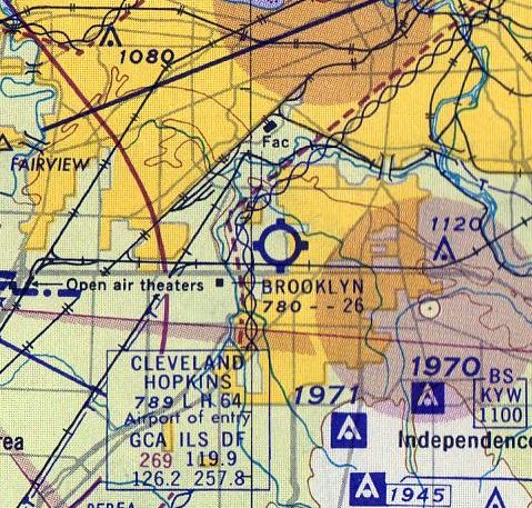
Brooklyn Airport was depicted as a commercial/municipal airport on the March 1940 Cleveland Sectional Chart.
The date of establishment of this small general aviation airport has not been determined.
Brooklyn Airport was not yet depicted on the February 1935 Cleveland Sectional Chart
nor on the 1939 USGS topo map.
The earliest depiction which has been located of Brooklyn Airport was on the March 1940 Cleveland Sectional Chart,
which depicted it as a commercial/municipal airport.
The earliest photo which has been located of Brooklyn Airport was a 10/2/43 aerial view looking northwest
in the 1945 AAF Airfield Directory (courtesy of Scott Murdock).
It depicted Brooklyn as having 3 unpaved runways, with a few small buildings along the southeast side.
The 1945 AAF Airfield Directory (courtesy of Scott Murdock) described Brooklyn Airport
as a 80 acre irregularly-shaped property having 3 sod runways, the longest being the 2,640' northeast/southwest strip.
Brooklyn Airport was said to have a single 64' x 60' wooden hangar,
and to be owned & operated by private interests.

An undated (circa 1940s?) photo of 3 unidentified people in front of the Brooklyn Airport Ideal Flying Service hangar,
with a Piper Cub peeking out of the hangar & another on the side.
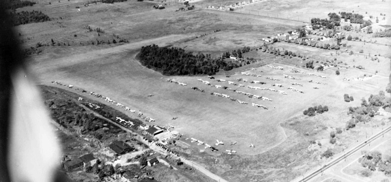
An undated (circa 1940s?) aerial view looking at a huge number of light aircraft parked at Brooklyn Airport.
According to Rick Wargo, Brooklyn Airport is mentioned in Peter Fusco's book “Moondog's Academy of the Air & Other Disasters”.
Brooklyn Airport may have gone through a period of closure or inactivity, as a 4/1/52 USGS aerial photo showed the field devoid of any aircraft,
in marked contrast to the earlier photo.
The 1953 USGS topo map depicted Brooklyn Airport as having 3 unpaved runways, with a few small buildings along the southeast side.
The 1960 Cleveland Local Aeronautical Chart depicted Brooklyn Airport as having a 2,600' unpaved runway.
Kathy Naugle recalled, “The Brooklyn Airport... our home was on a side street directly across the street.
I have a memory of seeing people run down to the end of my street & what I saw was a small private plane caught in the telephone lines hanging there.
I can't say exactly what year that would be but I would suspect around 1961.”
The last photo which has been located of Brooklyn Airport was a 12/1/62 USGS aerial view.
The 3 grass runways were still evident, but the number of aircraft on the field had dwindled to only a dozen.
As concerns the date at which Brooklyn Airport was closed, Kathy Naugle recalled, “I use to tramp around back in those fields up to 1965 & don't recall ever seeing any planes back there.”
The last depiction which has been located of Brooklyn Airport was on the 1968 USGS topo map,
which depicted it in the same fashion as on the 1953 USGS topo map.
Brooklyn Airport was evidently closed (for reasons unknown) by 1971,
as it was no longer depicted on the 1971 USGS topo map, with simply an unlabeled clearing depicted instead.
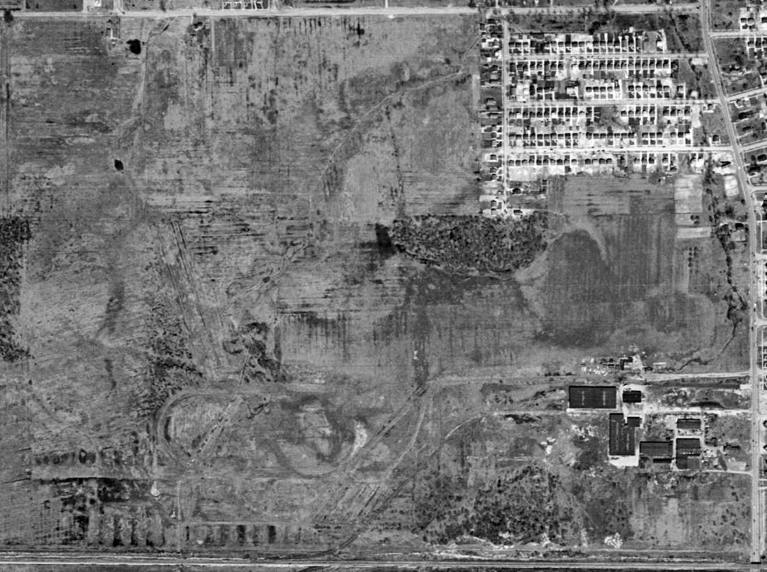
A 4/6/12 aerial view showed no trace remaining of Brooklyn Airport.
The site of Brooklyn Airport is located southwest of the intersection of Biddulph Road & Ridge Road.
Thanks to Rick Wargo for pointing out this airfield.
____________________________________________________
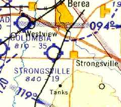
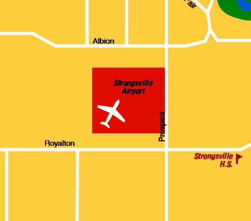
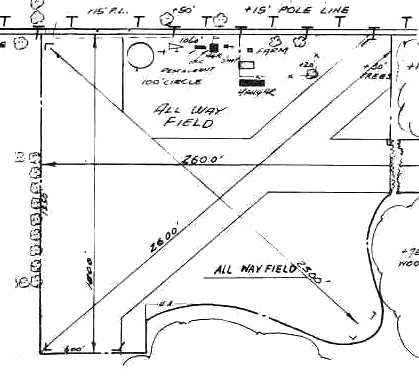
Strongsville Airpark (1G6), Strongsville, OH
41.325, -81.865 (Southwest of Cleveland, OH)
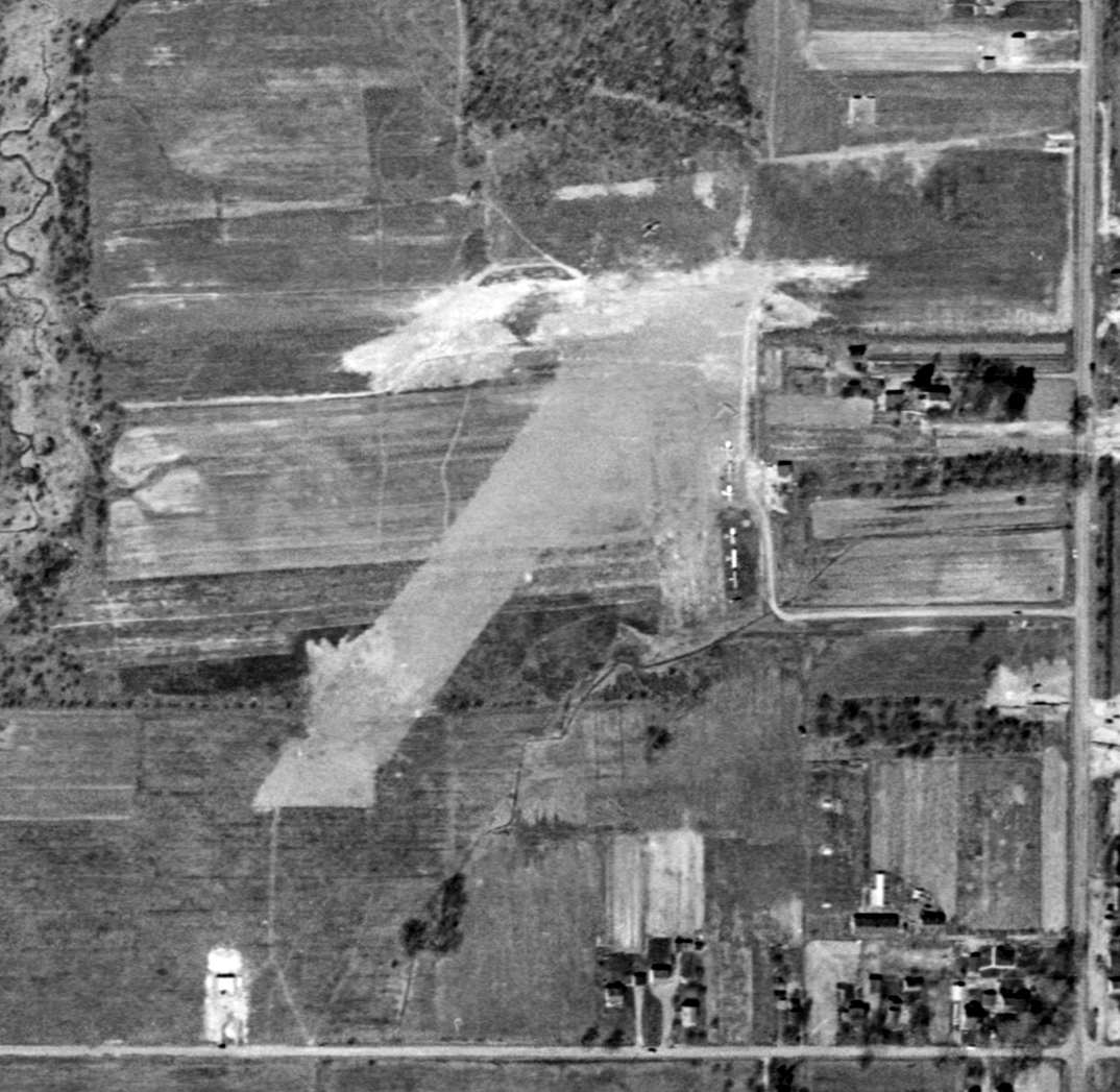
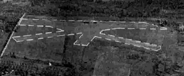
A 4/1/52 USGS aerial photo of Strongsville Airpark.
Yet another former general aviation airport, now lost to further housing construction.
The earliest depiction which has been located of the Strongsville Airpark was a 4/1/52 USGS aerial photo.
It depicted 6 light single-engine aircraft clustered around small shed on the east side of the field,
and 2 modest grass runways, oriented northeast/southwest & east/west.
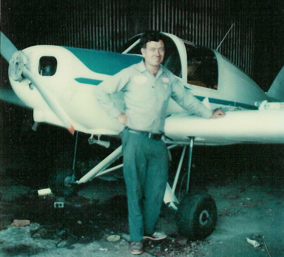
Strongsville Airpark was founded by Melvin Peters.

The 1953 USGS topo map depicted Strongsville Airpark as having 2 unpaved runways, labeled simply as “Landing Field”,
and a single hangar on the east side of the field.
Strongsville Airpark was was not yet depicted on the January 1955 Cleveland Sectional Chart.
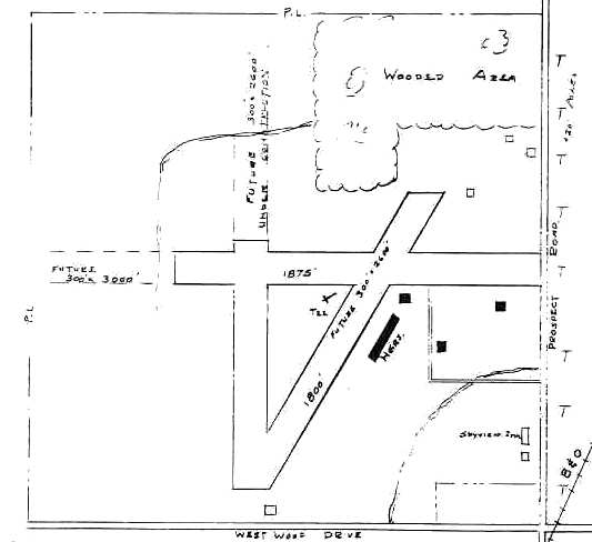
The 1955 OH Airport Directory (courtesy of Stephen Mahaley)
depicted Strongsville Air Park as having 3 runways, with the longest being an 1,875' east/west strip.
It also indicated plans for all 3 runways to be extended.
Several hangars were located along the southeast side of the field.
The operator was listed as Melvin Peters.
Libby Thompson recalled of Strongsville Airport, “I grew up on the airport property until I was 9.
The owner, Melvin Peters, was my step-grandfather
and his son, Ron Peters, pretty much ran the airport until we moved out of state.
We lived in a house that was located on the property,
and my brother & I used to race our mini-bikes on the runways at night after the airport closed for the evening.”
The July 1956 Cleveland Sectional Chart (courtesy of Chris Kennedy)
depicted Strongsville as having a 1,900' unpaved runway.
Strongsville apparently gained paved runways at some point between 1956-62,
as the 1962 AOPA Airport Directory described the field as having 2 asphaltic-concrete runways:
3,000' Runway 9/27 & 2,750' Runway 18/36.
The operator was listed as Melvin Peters.
A 1962 aerial view depicted Strongsville as having 2 paved perpendicular runways,
and over 2-dozen light aircraft parked around the field.
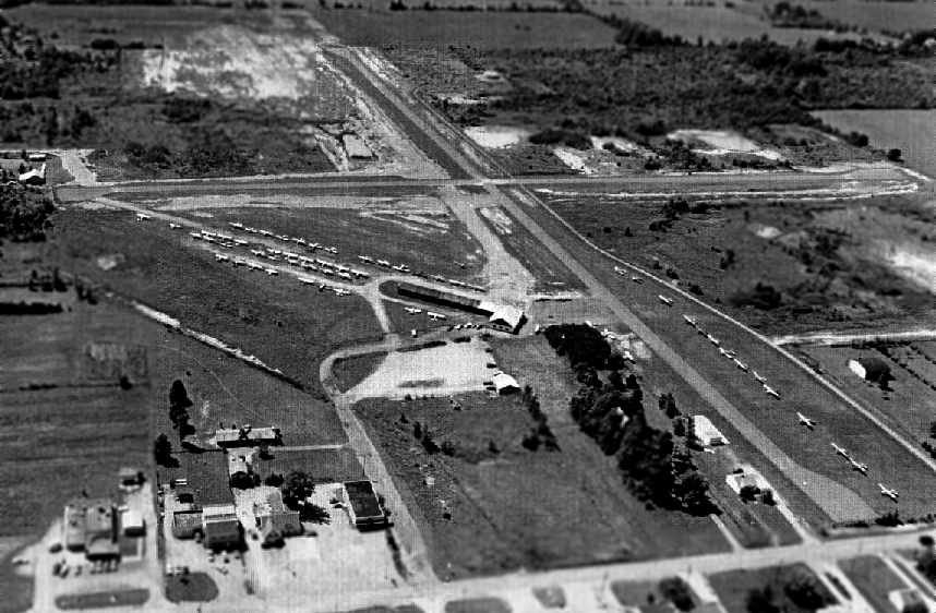
A circa 1965-66 aerial view looking west at Strongsville Airpark (courtesy of Wayne Peters).
It depicted the field as having 2 perpendicular paved runways,
with an office & main hangar on the southeast side,
and what may have been some smaller individual hangars along the east side of Runway 9/27.
Note the VOR beacon just beyond the runway intersection.
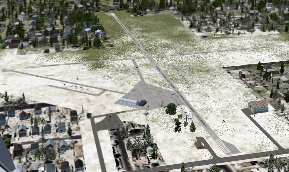
A flight simulator scenery depiction by Nick Newcomb showing Strongsville from the same perspective as the preceding photo.
Wayne Peters recalled, “I am the grandson of Mel Peters & the son of Ron [Peters].
It was quite a busy operation from the mid 1960's to the early 1970's.
We had a flight school & were a Cessna Dealer too.”

A 1965 brochure for Strongsville Airpark (courtesy of Wayne Peters).
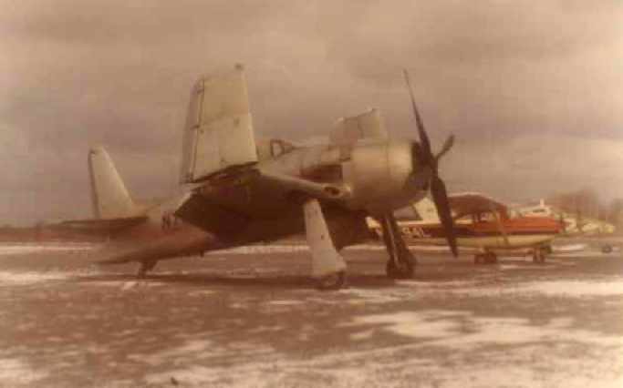
A January 1965 photo of a Grumman F8F Bearcat fighter & 2 Cessnas Strongsville Airpark (courtesy of Wayne Peters).
Wayne recalled, “A passing surplus Bearcat landed at our airport on its way west.”
Andy Dulay recalled, “I learned to fly at Strongsville & remember Mel Peters & his son running the operation.
A little-known fact is that Jim Bede's (BD-5, Bede Aircraft, etc) son was my original flight instructor at Strongsville!”
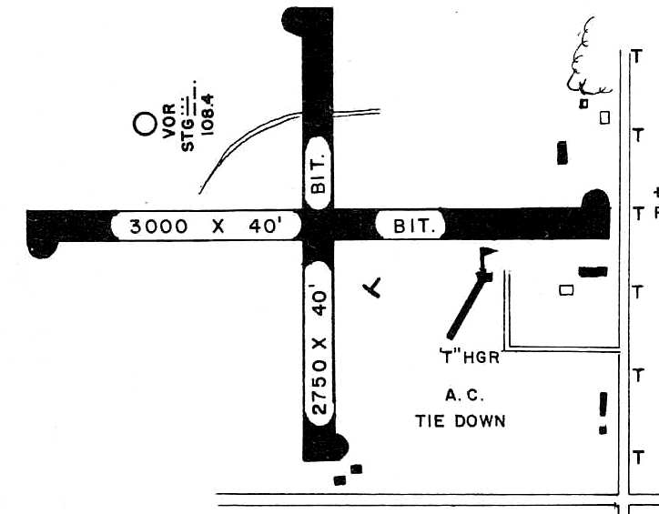
The layout of Strongsville Airport, as depicted on the 1966 OH Airport Directory (courtesy of Chris Kennedy).
The 2/5/68 State of Ohio Airport Certificate for Strongsville Airport (courtesy of Wayne Peters)
approved the field as a “Class II Airport”.
The last aeronautical chart depiction which has been located of Strongsville Airport was on the May 1970 Cleveland Sectional Chart.
It depicted Strongsville as having 2 paved runways, with the longest being 2,800'.
A 1970 aerial view depicted Strongsville as having 2 paved perpendicular runways,
and over 2-dozen light aircraft parked around the field.
Ron Miska recalled, “I worked as a line boy a Strongsville Air Park from 1970-72.
Ron & Mel [Peters] were great bosses. Working at Strongsville Airport was my first job, and has remained my favorite over the decades.
My starting pay was $1.40/hour.
Others who worked there at the same time as I did include: Jim Blessing, Walt Maxim, Ron Mitchell, Ron Weber, Greg Lann (flight instructors),
and Howie Barkfelt & Dick Gross (mechanics).
The line boys immediately before me were Tim Ur & Duane Bulla.
Including me, 4 Rons worked there at the same time. It got confusing when Mel called out over the intercom: 'Ron will you come into the office please?'
I used to dump spent oil on the ground. Then one day I got the clever idea to use the oil to spell out my initials (RM) in huge letters on a gravel taxiway.
It took many oil changes & several months to do it. You couldn’t really notice the letters from the ground, but they were very noticeable from the air.
About a month after I finished, a pilot walked in the office & asked Mel what those letters meant.
Mel had no idea what the guy was talking about. I was there & had to fess up. Mel could be quite stern, but instead of being angry, he laughed.
After this, his son Ron, whose name was Ronald M. Peters (RMP), used spent oil to add a 'P' after my initials!”
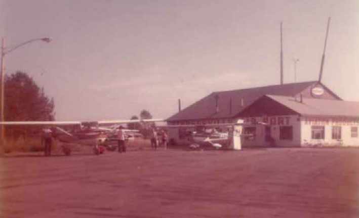
An early 1970s picture of 2 Cessnas in front of the Strongsville Airpark office (courtesy of Wayne Peters).
Wayne Peters recalled, “I used to work at the airport as a lineboy starting at age 14 [1972].
I also soloed at the airport in 1973 at the age of 16
and took my checkride for my Private Pilots license one year later at 17 at the field in a Cessna 150.
After my Grandad sold Strongsville Airport & property (190 acres) in 1974
to the developer who eventually built all the houses that now occupy the site,
Dad & Grandad split the profits of the sale & moved west.”
Glenn Shaw recalled, “Strongsville... I landed there in 1976. It was a nice airport.”
The last photo which has been located of Strongsville Airpark was a 1979 aerial view,
which depicted the field as being very popular, with dozens of light aircraft visible parked on the southeast part of the field.
The 1982 AOPA Airport Directory (courtesy of Ed Drury)
indicated that both runways had unfortunately been shortened to 2,200' in length.
The operator was listed as Strongsville Airport Corp.
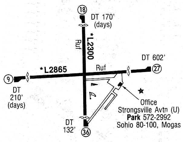
The condition of both runways at Strongsville was described
in the 1985 Flight Guide (courtesy of Chris Kennedy) as "Ruf" [sic].
According to an EPA report, Strongsville Airpark was closed in 1987.
Ground was broken in 1994 for the Westwood Farms subdivision on the site of the airport.
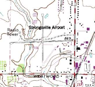
USGS topo map 1996.
The former airport was no longer depicted at all (even as an abandoned airfield) on the 1998 World Aeronautical Chart.
By the time of the 10/20/00 USGS aerial photo,
the airport site had been completely obliterated with a new housing development,
with not a trace remaining of the former runways.
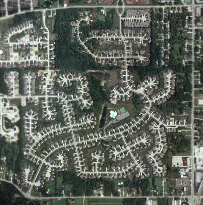
A circa 2001-2005 aerial photo showed the airport site had been completely obliterated with a new housing development,
with not a trace remaining of the former runways.
Bob Martel reported in 2003 that "At least one hangar is still standing & being used as a garage by a house on Prospect -
not part of the subdivision created on the former airport."
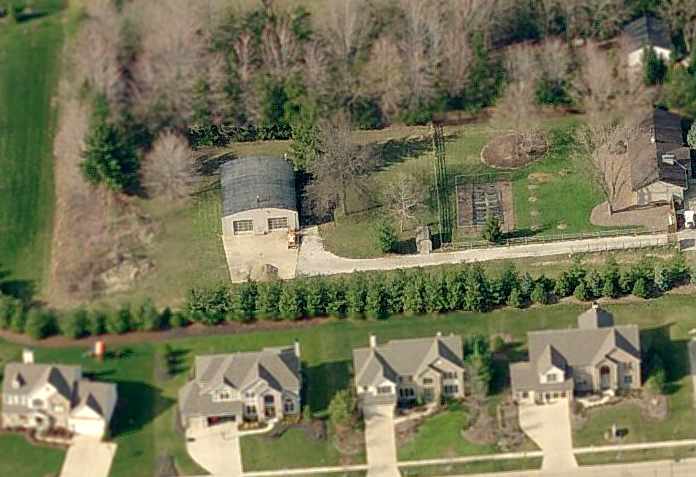
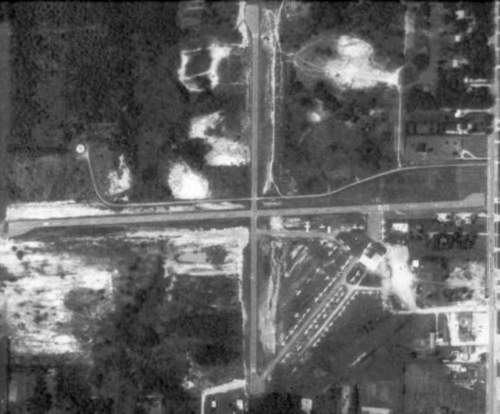
A circa 2006 aerial view looking north at a circa 1952-62 hangar which remains on the east side of the property,
apparently the last remnant of Strongsville Airpark.
Ironically, even though Strongsville Airpark has been closed for 13 years, it is still depicted on the 2010-2011 Cleveland Regional Transit Authority map (courtesy of Jimmy McGuire).
Cleveland: It might be time to update the map?
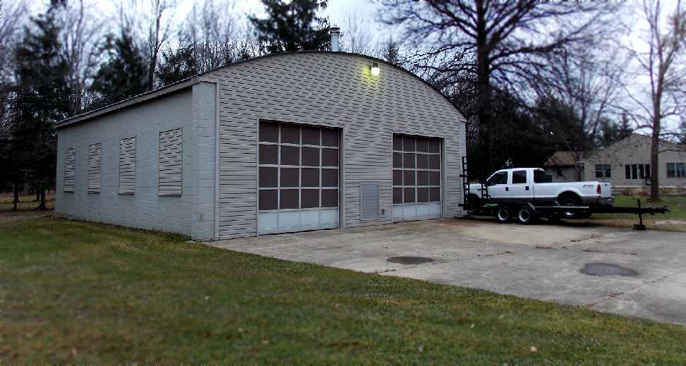
An 11/23/12 photo by Nick Newcomb looking northwest at the circa 1952-62 hangar which remains on the east side of the property,
apparently the last remnant of Strongsville Airpark.
The site of Strongsville Airpark is located northwest of the intersection of Prospect Road & Westwood Drive.
Thanks to Jonathan Westerling for pointing out this airfield.
____________________________________________________
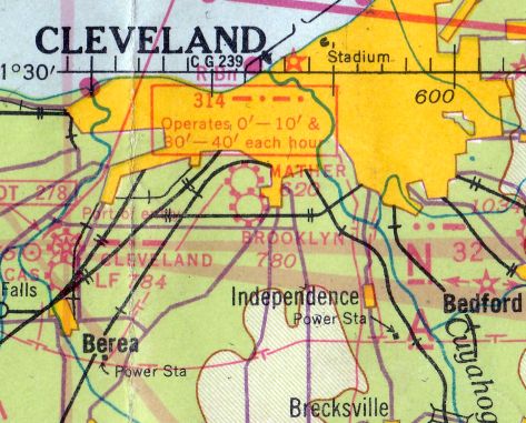
Ingalls Field / Ingalls Airport, Hunting Valley, OH
41.48, -81.4 (Southeast of Cleveland, OH)
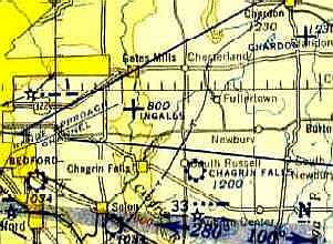
Ingalls Field, as depicted on the April 1943 Cleveland Sectional Chart.
According to www.firstworldwar.com, “David Sinton Ingalls was the U.S. Navy's sole air ace of World War I, achieving 6 victories in the air in a 6 week period in 1918.”
According to the Western Reserve Land Conservancy, this property included “David Ingalls' legendary landing strip...
on which renowned aviators such as Charles Lindbergh touched down.
Lucky Lindy frequently visited his friends in Hunting Valley after his 1927 solo flight across the Atlantic Ocean.”
Ingalls Field was not depicted on the March 1940 Cleveland Sectional Chart.
The only aeronautical chart depiction which has been located of Ingalls Field was on the April 1943 Cleveland Sectional Chart.
It depicted Ingalls as an auxiliary airfield.
Ingalls Field was no longer depicted on the June 1945 Cleveland Sectional Chart (courtesy of Dick Merrill).
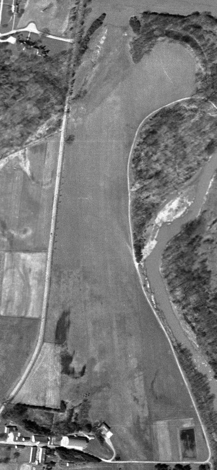
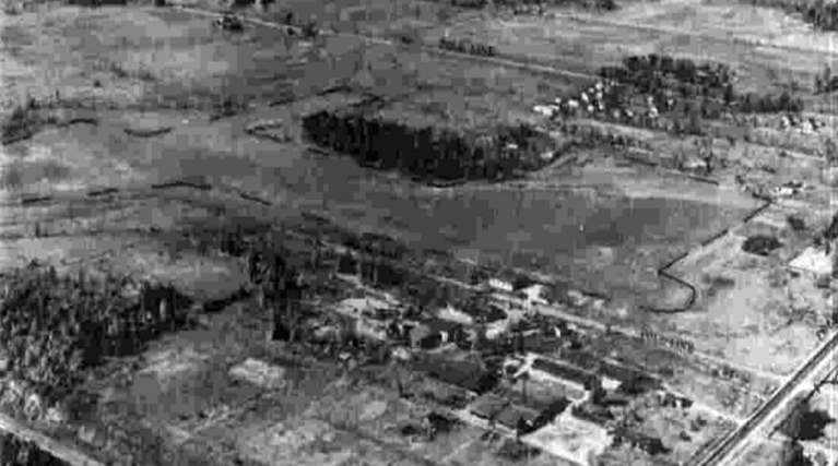
The earliest photo which has been located of Ingalls Field was a 4/16/52 USGS aerial view.
It depicted Ingalls as having a single north/south grass runway, with a hangar at the southwest end.
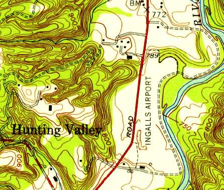
The earliest topo map depiction which has been located of Ingalls Airport was on the 1953 USGS topo map.
It depicted Ingalls Airport as a north/south clearing, with 2 small buildings on the southwest corner.
According to Kevin Dunn, “David Ingalls kept a C90 King Air here. [He] even had lights on this sod strip.
I recall flying over Ingalls Field many times. [I] saw a Beech King Air C90 sitting outside the hangar.”
According to Dudley, “it was David Jr. [Ingalls] that owned the Baron & operated from his private strip in the 1960s.”
Jim Hackman recalled, “As a 26 year old Certified Flight Instructor & sales demonstration pilot
I demonstrated N7034D Beech Duke serial # P-9 in & out of Ingalls, I believe on 5/22/69.
The mission was to see if the Duke would fit in the hangar replacing the Baron. Also to let David Sr. fly it.
The short-wing BE-60 Duke was not a short-field airplane.
The upside-down numbers on the far end of the runway are to tell a Duke pilot where to rotate.
Admiral Ingalls taxied up the hill at the north end, turned & launched.
We rotated in front of the hangar with a few hundred feet left.
Flight was OK but I was really concerned about the landing.
Our experience was that anything below 100 knots in the Duke on final was TOO slow.
The Admiral got it down with my encouragement.
The chose not to buy a Duke which was likely a good thing for them & for the Beech.”
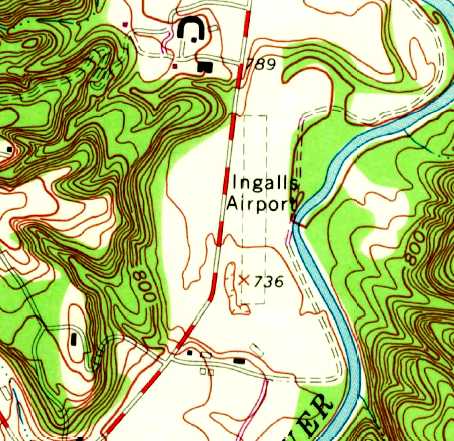
The last map depiction which has been located of Ingalls Airport was on the 1970 USGS topo map.
It depicted Ingalls Airport as having a single unpaved north/south runway, with several small buildings on the southwest corner.
Ingalls Airport was no longer depicted on the 1979 USGS topo map.
According to Kevin Dunn, “Rumor goes one of the Ingalls kids had a Cessna Citation 1 & landed it there.
It was too heavy & it was buried in the grass & mud up to the gear locks!
I believe the airport closed around 1980.”
Max Johnson recalled, “I grew up across the street from the Ingalls property on another Hunting Valley estate,
where my Father was the gardener & my Mother worked in the main house as a cook/housekeeper.
I can confirm the blurb about Ingalls' son trying to take off on a muddy field in 1980 & sinking the plane to the door locks.
The engines sucked up so much mud & debris that they had to be removed from the plane and shipped out for repair.
If I remember the story correctly, they were shipped to a company in Texas & the repair bill was well into the 6 figures.
The Ingalls estate caretaker was tasked with maintenance of the facility.
He had a radio in his home so that Mr. Ingalls could call ahead to get the strip lights turned on in advance of an arrival.”
According to www.firstworldwar.com, David Ingalls “died on 4/26/85 in Hunting Valley at the age of 86.”
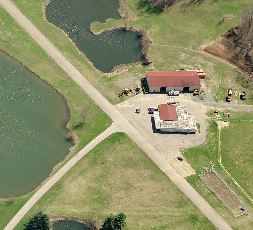
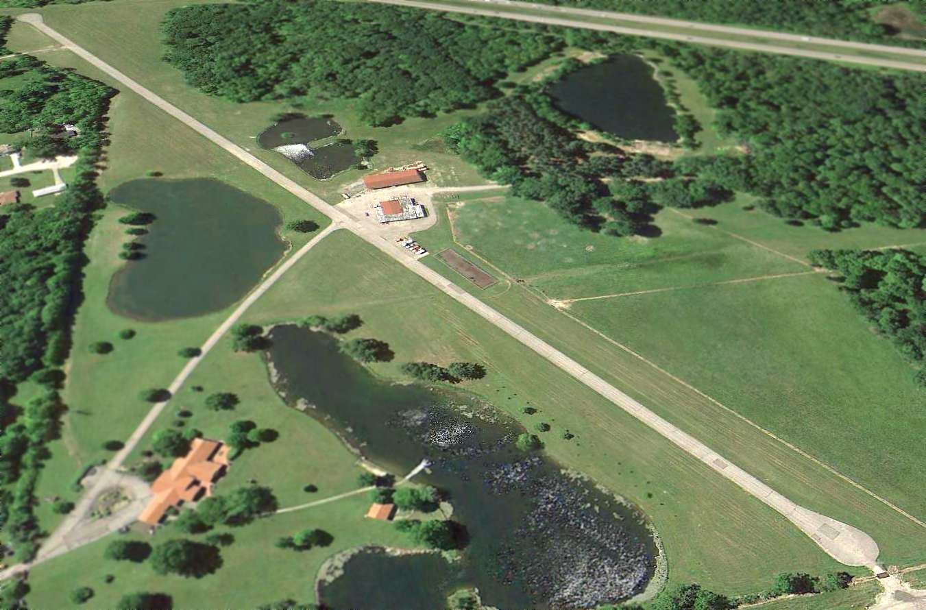
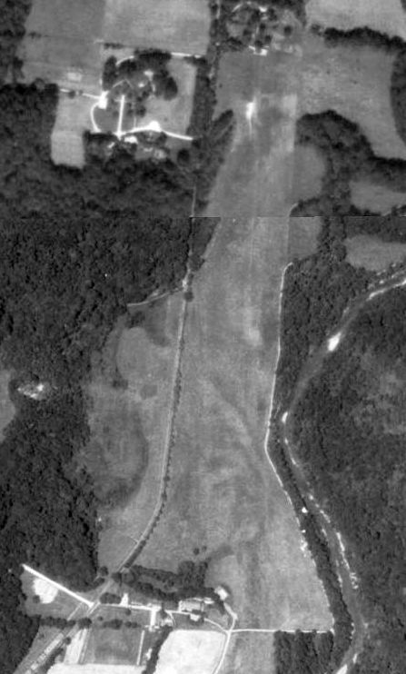
A circa 2008-2011 aerial view looking west at the Ingalls Field hangar, showing the doors open.
A 11/3/11 aerial view showed Ingalls Field remained completely intact.
A 4/7/12 aerial view looking northwest at Ingalls Field,
showing that a small road or path had been cut across the northern portion of the runway at some point between 2011-2012.
Max Johnson recalled, “In my teenage years, I worked for Mr. Ingalls' daughter, who owned a house & property at the north end of the airstrip.
I planted most of the pine trees you can see in the recent photos.
I also had the unenviable task of weed eating around the hangar & the length of the fence line (which was close to a mile long).”
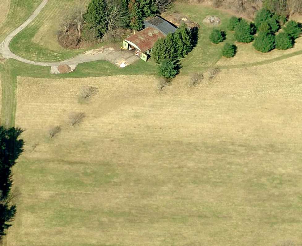
An August 2012 photo by Kevin Dunn looking north at the Ingalls Field hangar.
An August 2012 photo by Kevin Dunn looking north along the Ingalls Field runway.
An August 2012 photo by Kevin Dunn of the electrical controls for Ingalls Field's field lights & fuel pump.
Lee Janotta reported in 2016, “Ingalls Airport is a horse ranch now, with paddocks on the runway.
There's a structure that looks like it could be the old hangar, restored.”
Ingalls Field is located southeast of the intersection of Fairmount Boulevard & Chagrin River Road.
____________________________________________________
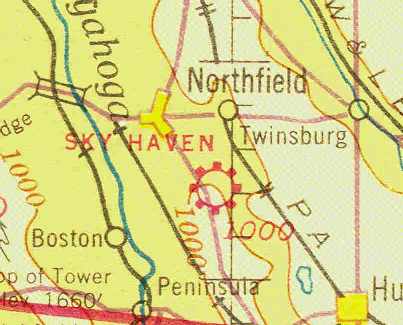
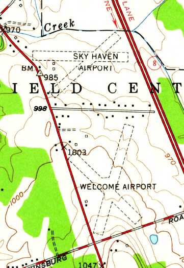
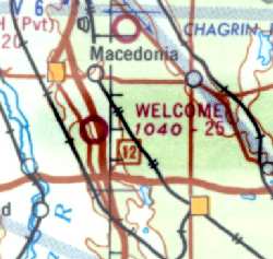
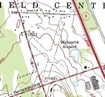
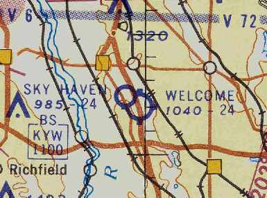
Sky Haven Airport (original location) / Welcome Airport / Northfield Airport, Northfield, OH
41.285, -81.515 (Southeast of Cleveland, OH)
An aerial view looking east at Sky Haven Airport,
from The Airport Directory Company's 1938 Airports Directory (courtesy of Chris Kennedy).
The following information about Sky Haven / Welcome Airport was compiled by Jonathan Westerling:
"Welcome Airport remained open for some 50 years, serving local pilots with its nice turf runways.
The early history of the Welcome airport is best told by longtime pilot Russ Sholle,
who was intimately familiar with the airport."
Russ Sholle recalled, "Edward 'Slim' Honroth came to Northfield in 1933 and opened the Sky Haven Airport.
He came with a fellow pilot named Gail Mishler.
Slim had a 1927 WACO 9 Biplane & Gail had a Kinner Bird Biplane.
I tended to hang around the airport as often as possible [as a kid] since it was exactly one mile from our home.
When I was 14 years old I started doing odd jobs around the airport - greasing the valve rockers... etc.
As pay, Slim would give small bits of time in the air & I accumulated maybe 5 or 6 hours this way."
The 1934 Department of Commerce Airport Directory (according to Chris Kennedy)
described Sky Haven as having 3 sod runways.
The Airport Directory Company's 1938 Airports Directory (courtesy of Chris Kennedy)
described Sky Haven as having 3 sod runways, with the longest being a 2,300' northwest/southeast strip.
The earliest chart depiction of Sky Haven Airport which has been located
was on the February 1941 Cleveland Sectional Chart (courtesy of Chris Kennedy).
It depicted Sky Haven as a commercial airport.
Sky Haven was depicted as a commercial airfield
on the April 1943 Cleveland Sectional Chart (courtesy of Barnard Kemter).
A 10/7/43 aerial view looking west from the 1945 AAF Airfield Directory (courtesy of Scott Murdock)
depicted Sky Haven Airport as having 3 unpaved runways.
Sky Haven was listed as an active airfield in the 1944 US Army/Navy Directory of Airfields (courtesy of Ken Mercer).
The June 1945 Cleveland Sectional Chart (according to Chris Kennedy)
depicted Sky Haven as an active airfield.
The 1945 AAF Airfield Directory (courtesy of Scott Murdock) described Sky Haven Airport
as a 100 acre irregularly-shaped property containing 4 clay, loam, and sod runways, with the longest being the 2,500' north/south strip.
The field was said to have 2 wooden hangars, the largest being a 64' x 48' structure.
Sky Haven was described as being owned & operated by private interests.
A 1946 photo by Russ Sholle (courtesy of Jonathan Westerling) of several taildraggers in front of a hangar at Sky Haven Airport.
Russ Sholle recalled, "I believe was late 1947 that Slim [Honroth]
lost his lease on his airport & we moved Sky Haven to its new location one mile north on Route 8.
A very interesting situation with 2 airports that close to each other having almost intermingling patterns."
The old Sky Haven airport location was bought by Mel Barron
and renamed Welcome Airport after Slim sued to give the name Sky Haven to his new airport.
However, strangely, there was no airport depicted at either location (Sky Haven or Welcome Airport)
on the 1949 Cleveland Sectional Chart (courtesy of Chris Kennedy).
The November 1950 Cleveland Sectional Chart depicted Welcome Airport as having a 2,500' unpaved runway.
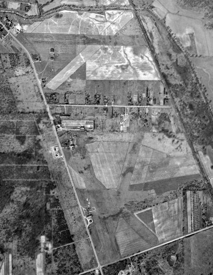
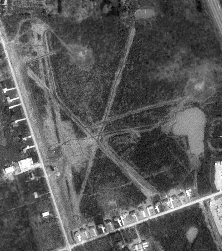
A 4/1/52 USGS aerial photo depicted both the new Sky Haven Airport & the Welcome Airport.
Welcome Airport was depicted as having 4 unpaved runways, with 3 single-engine aircraft parked around a few small buildings on the west side.
The 1953 USGS topo map depicted both the new Sky Haven Airport & the Welcome Airport.
Welcome Airport was depicted as having 2 unpaved runways, with a few small buildings on the north & west sides.
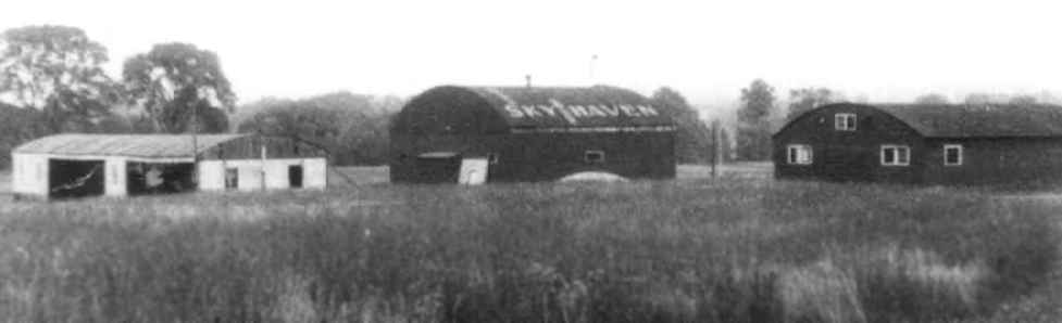
An undated photo (courtesy of Sam Ciocco) of 3 hangars at Sky Haven, one of which had the airport's name painted on the roof.
The 1955 Ohio Airport Directory (courtesy of Jonathan Westerling) described Welcome Airport
as having 3 grass runways: 2,400' north/south, 2,450 northwest/southeast, and 1,300' east/west.
The owner was listed as Welcome Aviation.
Both Welcome Airport & the 2nd location of Sky Haven Airport were depicted
on the January 1955 Cleveland Sectional Chart (courtesy of Chris Kennedy)
and the January 1958 Cleveland Sectional Chart (courtesy of Chris Kennedy).
Rich Peabody recalled, "I remember being perplexed about the proximity of these 2 airports when young.
It was even more confusing from the air... the patterns seemed to conflict in major ways.
Welcome had quite a few Swifts based there...
and the Swift can become fairly confusing in a hurry, what with hand cranked gear...
I recall that it became an almost annual event to learn that another Swift
had become captured by the trees that stood between the farm & Twinsburg Road...
especially hot, humid summer days, after rain, when the sod sucked the crafts to the ground a bit longer than expected."
By the time of the 1962 Cleveland Sectional Chart (courtesy of Jonathan Westerling),
only Welcome Airport was still depicted.
A 1962 aerial view depicted a total of 11 light aircraft parked around a few small buildings on the southwest side of the field.
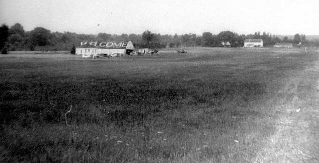
A 1964 photo of the modest rural airport, with 5 planes parked on the field.
(Photo courtesy of the Historical Society of Olde Northfield, via Jonathan Westerling)
The 1964 Nordonia Hills directory of Community Organizations listed the Welcomaires as being based at the field.
"The Welcomaires was formed with the idea of promoting social & flying activities
among those who have an interest in flying, especially at Welcome Airport.
The Club has 45 members.
There is a clubhouse to be used as a lounge & meeting place for the club members
where they can plan & carry out their social functions."
The 1967 AOPA Airports USA guide listed the airport as having 3 active runways:
2,400' sod Runway 2/20, 2,500' turf Runway 14/32, and 2,500' sod Runway 17/35.
R.J. Grega reported that his father had designed & built a homebuilt airplane (a GN-1 Aircamper) at Welcome Airport.
"His EAA club met out of old Welcome Airport, and he flew the airplane he designed out of that airport."
Susie Avant recalled, “Welcome Airport... John Coleman was the owner, manager, chief bottle washer in the late 1960s & 1970s.
There was also a lady by the name of Julie.”
The 1972 USGS topo map depicted the field as "Northfield" Airport.
Joseph Martanovic recalled, “The people in the 1970s at Northfield–Welcome were wonderful.
I was out of college & the Army & I wanted to learn to fly more than anything in my life... and I did, thanks to so many of them.
Later I got my instrument & commercial [pilot's license] and owned a Cessna 172 & the 'cherriest' 152 ever.
I did a lot of aerial photo work, since I was a business real estate broker.
It legitimized my flying to my bosses, wife, and the IRS. It was a magnificent part of my life. Much more than a hobby like golf or skiing. It was a way of life.”
In 1981 the lease for the airport was transferred to the Northfield Pilots Association
whose 82 members stored about 40 aircraft on the field.
In 1987, the landowner, the DeBartolo Corp., offered the land to the association for $2 million.
Unable to pay that amount, the airport lease was revoked in favor of a "new project" on the site.
A 1987 photo by Ross Sholle (courtesy of Jonathan Westerling)
of the main hangar at Welcome Airport, taken on the day of the airport's closure.
A 1987 aerial view of Welcome Airport taken by Ross Sholle (courtesy of Jonathan Westerling)
from his "Baby Lakes" biplane on the day of the airport's closure.
Ann Reville, who still lives across from the airport site, wrote on occasion of the airports closing,
"We moved our business out here because we liked the area & especially enjoyed the airport.
Many events have taken place [at the airport] including clambakes, parties, airshows, and more.
These events have brought people out to Northfield from Portage, Geauga, Cuyahoga and Lake counties.
We have been involved with the airport as long as we have lived here...
the closing is a shock to our family & other area pilots."
The 1994 USGS topo map still depicted Welcome Airport, with 2 grass runways.
A 4/14/94 USGS aerial photo still showed 3 unpaved runways at Welcome Airport, although it appeared the hangars along the west side had been removed.
According to Jonathan Westerling,
"In the mid-1990s a housing development was erected where the airport had been for decades.
I visited the site in 1996, and the rooftops of the 'Charter Lakes Estates' had recently been completed.
I couldn't see any remnants of the airfield,
though I believe the proprietor's quarters & clubhouse at the north end of the field are now a private residence."
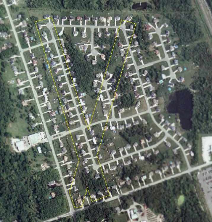
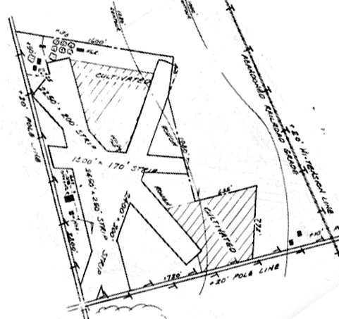
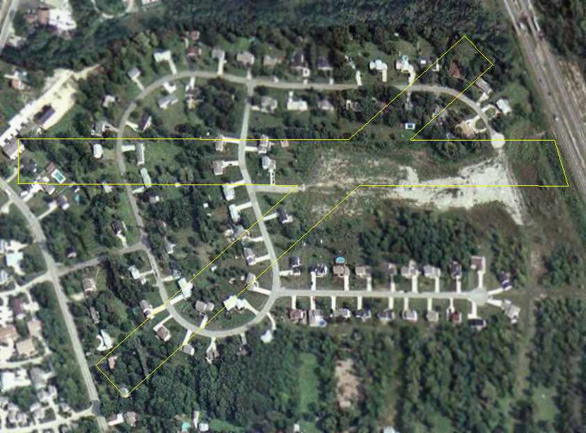
A 2006 aerial photo of the site of the Welcome Airport,
annotated by Chris Kennedy to show the layout of the 2 former runways.
The site of the former Welcome Airport is located at the intersection of Olde 8 Road & Twinsburg Road.
____________________________________________________
Sky Haven Airport (2nd location), Northfield, OH
41.293, -81.515 (Southeast of Cleveland, OH)
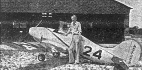
A 1949 photo (courtesy of Jonathan Westerling) of Slim Honroth, the founder of Sky Haven Airport,
pictured in front of an experimental plane, presumably at the 2nd location of Sky Haven Airport.
According to longtime pilot Russ Sholle, "I believe was late 1947
that Slim [Honroth] lost his lease on his airport [the original Sky Haven Airport]
and we moved Sky Haven to its new location one mile north on Route 8.
[It was] A very interesting situation with 2 airports that close to each other having almost intermingling patterns."
Inexplicably, there was no airport depicted at either location (Sky Haven or Welcome Airport)
on the 1949 Cleveland Sectional Chart (courtesy of Chris Kennedy).
Russ continued, "The name Sky Haven continued in our new location.
Unfortunately, Slim was killed 2 years later testing a midget Racer that he had refurbished at Akron airport.
His wife Lucille continued to operate the new Sky Haven
and I went back to help her with the Civil Air Patrol program."
The November 1950 Cleveland Sectional Chart depicted Sky Haven Airport as having a 2,400' unpaved runway.
The last photo which is available of the new Sky Haven Airport was a 4/1/52 USGS aerial photo, which also depicted the adjacent Welcome Airport to the south.
Sky Haven Airport was depicted as having 2 unpaved runways, with a few small buildings on the southwest side.
The 1953 USGS topo map depicted both the new Sky Haven Airport & the Welcome Airport.
Sky Haven Airport was depicted as having 2 unpaved runways, with a few small buildings on the southwest & south sides.
Both Welcome Airport & the 2nd location of Sky Haven Airport were depicted
on the January 1955 Cleveland Sectional Chart (courtesy of Chris Kennedy).
The "new" Sky Haven Airport was depicted as having a 2,400' unpaved runway.
The 1956 OH Airport Directory (courtesy of Chris Kennedy)
depicted Sky Haven as having 2 sod runways, with the longest being the 2,400' east/west strip.
Two small buildings were depicted just southwest of the runway intersection.
The field was said to offer fuel & storage,
and the manager was listed as Mrs. E. P. Honroth.
The field was depicted as being located on the northwest corner of Route 8 & Hazel Drive,
directly across Hazel Drive from Welcome Airport.
The last chart depiction of Sky Haven Airport as an active airport which has been located
was on the January 1958 Cleveland Sectional Chart (courtesy of Chris Kennedy).
Rich Peabody recalled, "I remember being perplexed about the proximity of these 2 airports when young.
It was even more confusing from the air... the patterns seemed to conflict in major ways.
Welcome prevailed... I remember there were rumors that Sky Haven was going to be a 'fly-in' community,
but upon aerial inspection, there were no runways."
According to Russ Sholle, "I don't know exactly when she [Lucille Honroth] closed the airport
but it became a housing development."
The 2nd location of Sky Haven Airport was closed at some point between 1958-62,
as a 1962 aerial view depicted houses covering the southwest portion of the site.
Sky Haven Airport was no longer depicted at all on the 1962 Cleveland Sectional Chart (courtesy of Jonathan Westerling)
or the 1963 USGS topo map.
A 4/14/94 USGS aerial photo of the site of the 2nd location of Sky Haven Airport
did not show any trace of a former airport - the site was covered by housing & trees.
A 2006 aerial photo of the site of the 2nd location of Sky Haven Airport,
annotated by Chris Kennedy to show the layout of the 2 former runways.
The site of the 2nd location of Sky Haven Airport is located northwest of the intersection of Route 8 & Hazel Drive.
The former airport is commemorated by the names of one of the streets
in the residential development which occupies the site - Skyhaven Road.
____________________________________________________
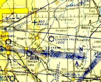
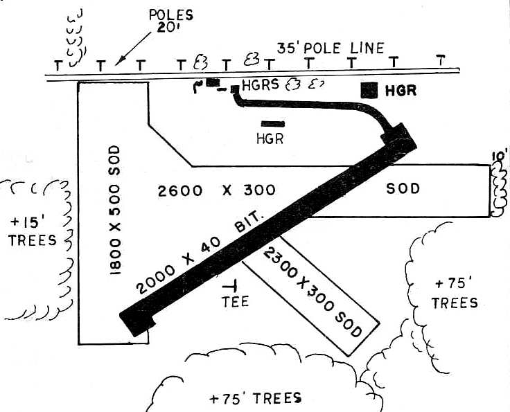
Chagrin Falls Airport (5G1), Chagrin Falls, OH
41.43, -81.333 (East of Cleveland, OH)
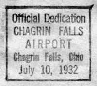
A postmark commemorating the 7/10/32 dedication of Chagrin Falls Airport.
The Chagrin Falls Airport was officially dedicated on 7/10/32, according to a commemorative postmark.
An article in the 7/14/32 issue of the "The Chagrin Falls Exponent" (courtesy of Phil Sasak)
was entitled "Thousands at Airport Sunday - Dedication & Air Show Attracts Crowds Beyond All Expectations".
It described the dedication of the Chagrin Falls Airport:
"Over 10,000 Estimated In Attendance - David Ingalls Delivers Dedication Address -
Roads Blocked For Miles While Stunts Were In Progress -
Many Famous Flyers Guests - 28 Ships in Attendance.
Chagrin Falls on Sunday was the aviation center of the country
when it had as its guests a majority of the most important flyers of the United States, at the dedication of its new airport."
The article continued, "David Ingalls, naval war ace, flew from his home in Hunting Valley to the airport & made the dedicatory speech.
He told the thousands that had gathered that, 'airports are the backlog of aeronautical development.
It is a great tribute to the progressiveness of Chagrin Falls that your citizens are taking up this most modern form of transportation.'
The dedication service was held in the new hangar
and the voices of F.J. Rowe, chairman of the arrangements,
Mayor J.C. Steel, and David S. Ingalls were carried over the loud speaker system on the field,
so the thousands that had flocked to the airport to see the imposing array of famous flyers
whose aerial demonstrations were part of the dedication, could hear the program."
The article continued, "The list of visiting pilots included Major 'Jimmy' Doolittle
(winner of the Bendix trophy race & holder of the west-east transcontinental record),
Major Alexander deSeversky (Russian war ace), and Eddie Rickenbacker.
Three planes of the 112th Observation Squadron of the OH National Guard
opened the program with an exhibition of formation flying.
Then, Major Seversky, flying a gold & white biplane,
gave an exhibition of stunt flying which included some of the most intricate maneuvers known to aviation."
The article continued, "A stiff wind aided James Ray, of Philadelphia, the country's leading autogyro pilot,
in taking off in his 'windmill' ship with practically no running start.
He climbed steeply & after hovering about the field for some minutes, came straight down to an easy landing.
At 4:00 Postmaster Howard Foster dispatched a special pouch of mail
containing 388 letters with a special dedication stamp.
This was the first mail from the airport.
D.C. Stem flew the plane carrying the postmaster & the mail to the Cleveland airport.
It was hard to estimate the exact size of the crowd as there was no way to check them,
but it is safe to say that over 10,000 people visited the airport on Sunday.
Some 28 different ships landed at the airport during Sunday, and the last of the flyers departed Monday afternoon.
No accidents occurred except for the Standard Oil ship nosing over in the strong wind during the morning.
The airport is on the Albert Warren farm 2 miles east of Chagrin Falls on Bell Road."
The Airport Directory Company's 1933 Airports Directory (courtesy of Chris Kennedy)
described Chagrin Falls as a commercial airport having 2 sod runways: 2,850' east/west & 2,650' north/south.
A hangar & other buildings were said to be located on the northeast side of the field.
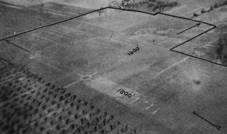
The earliest depiction which has been located of Chagrin Falls Airport was an undated aerial view looking northeast
from The Airport Directory Company's 1937 Airports Directory (courtesy of Bob Rambo).
The directory described Chagrin Falls as having 2 sod runways: an 1,800' north/south strip & a 1,600' east/west strip.
The hangar was described as having "Chagrin Falls" painted on the roof.
The earliest aeronautical chart depiction which has been located of Chagrin Falls Airport
was on the April 1943 Cleveland Sectional Chart (courtesy of Barnard Kemter).
It depicted Chagrin Falls as a commercial/municipal airfield.
A 10/7/43 aerial view from the 1945 AAF Airfield Directory (courtesy of Scott Murdock)
depicted Chagrin Falls Airport as having an open grass landing area.
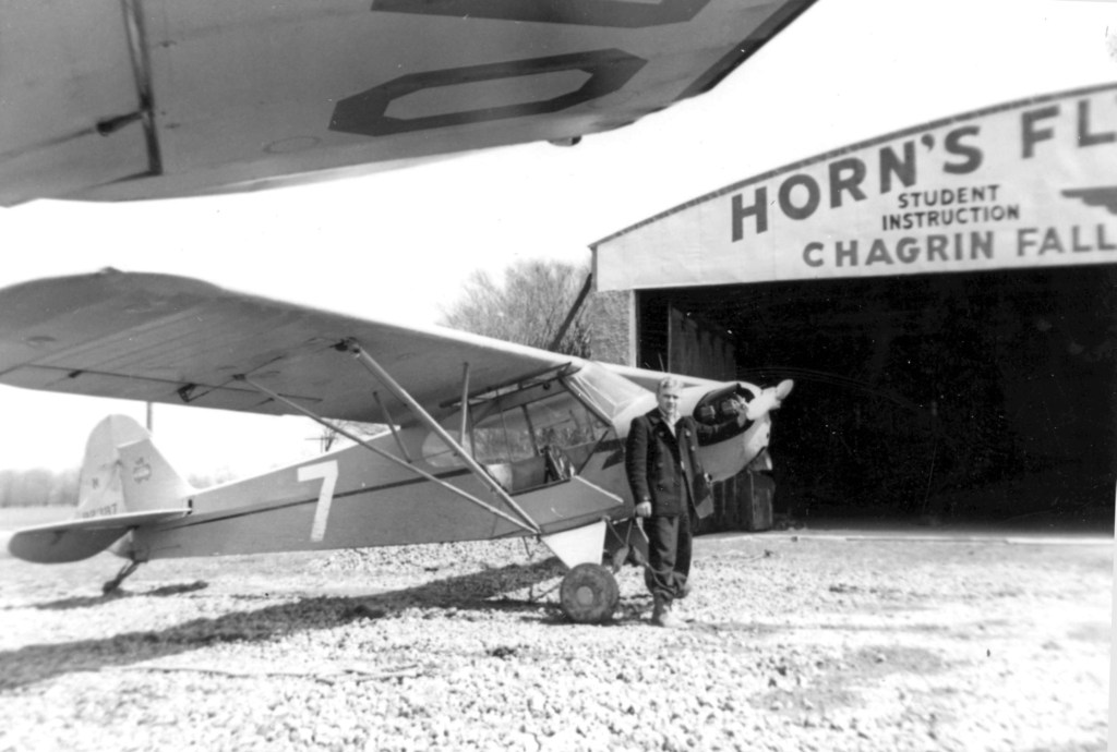
A Spring 1947 photo of a 20 year old Joe Hustosky in front of a Piper Cub & a Horn's Flying School hangar at Chagrin Falls (courtesy of Al Hustosky).
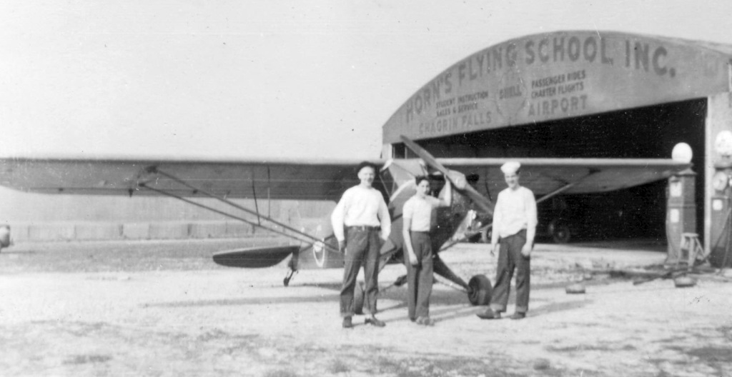
A Spring 1947 photo of 3 unidentified men in front of a Piper Cub & a Horn's Flying School hangar at Chagrin Falls (courtesy of Al Hustosky).
According to a history of the area, many famous Americans visited or flew into the airport
and hundreds of pilots trained there during & after WW2.
The 1945 AAF Airfield Directory (courtesy of Scott Murdock) described Chagrin Falls Airport
as a 90 acre irregularly-shaped property containing 4 clay & sod runways, with the longest being the 2,100' northeast/southwest strip.
The field was said to have 2 hangars, the largest being an 80' 60' steel & tile structure.
Chagrin Falls was described as being owned & operated by private interests.
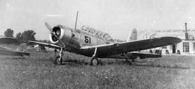
A circa 1940s photo of a Vultee BT-13 at Chagrin Falls (courtesy of Bob Wing).
Bob Wing recalled, “Chagrin Falls Airport... where my father & grandfather learned to fly.”
Steve Krieger recalled, “For many of my younger years, I lived directly across Bell Road from the old Chagrin airfield.
As a young child, I used to sit in my gravel driveway & drive my cast-metal planes through 'take off' & 'landing'
while watching the real thing occur across the street.
I used to walk across the street to the old hangar & poke around, looking at the planes that were in the hangar or parked (tied down) outside.
There was at that time a biplane or two based there - I was too young to know what type they were.
But I do remember seeing a yellow Piper Cub (remember the "teddy bear" on the tail!) at the time.”
Ruth Mc Ilrath Cavanagh reported, "My dad was David Mc Ilrath
who was the lead instructor at Horn's Flying School for a long time.
He grew up with that airport.
Don Hein did manage the place for Wilbur Horn.
He took less pay but made up for it in that he slowly became owner of the place over a long period of time.
Clifford Rentz… he & his brother Gene were custodians & flyers at the airport.
My dad part-owned a plane with the Rentz brothers in the late 1940s,
how they loved flying, but had no money to support the habit.
I am sure it is why my dad taught."
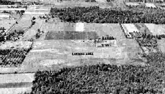
A 1952 aerial view depicted Chagrin Falls as an open grass field,
with several buildings & 4 light aircraft along the north side.
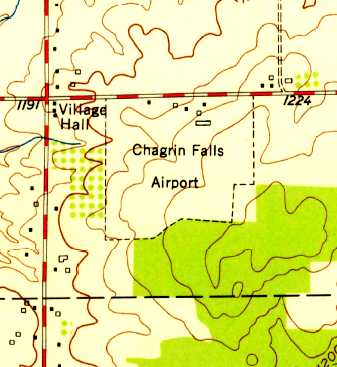
The 1953 USGS topo map depicted Chagrin Falls Airport as an irregularly-shaped outline, with several buildings along the north side.
As depicted on the 1953 Flight Chart (courtesy of Scott O'Donnell),
Chagrin Falls Airport had a 2,600' unpaved runway.
D.S. Braden recalled, “I learned to fly & soloed at the Chagrin Falls Airport in 1954 - as I recall it was a Piper J3.”
The 1955 OH Airport Directory (courtesy of Stephen Mahaley)
depicted Chagrin Falls as having an all-way landing area, measuring 2,600' x 1,500'.
Several small hangars were located along the north side of the field.
The operator was listed as Horns Flying School Inc.,
and the manager was listed as Don Hein.
Herbert Rosenthal recalled, “Chagrin Falls Airport... I learned to fly there in 1958-59 when I was in high school.
Piper Cubs. It had about 4 runways & eventually paved one of them.
After I moved to Washington, DC, from Cleveland, I would fly home to visit family
and Chagrin Falls was as good as any place to land as it was about 20 minutes from relatives.
David McIlrath was an instructor when I was there. He was the postmaster I believe in Chagrin Falls.
He gave me the night training I needed to remove the night restriction from my commercial certificate. We waited until September.
He put several battery or kerosene lanterns along the east/west runway
and on one or two nights, I completed whatever nighttime was needed to remove the restriction.
I think David Ingalls had his own private airstrip on his estate nearby.
Don Hein was a designated examiner. But in 1959 the FAA wanted to bring all the flight tests in-house to inspectors.
It was September of 1959 & I had spent many hours trying to get ready for my private check ride -
just finding decent weather for my long cross country took a long time.
My going to freshman year at college was fast approaching
and Don Hein inveigled the FAA GADO to allow him to give me my private pilot flight test as an examiner a day or two before I had to depart.
In 1961 in the summer when after about two months, I earned my LFI,
Don was good & gave me students near completion so that I could have 5 recommendees pass their flight test & convert to a CFI.”
Roald Lutz recalled, “I grew up at Chagrin Falls Airport.
My Dad hangared his Stinson Voyager there from 1961 until it closed in 1979.
We had the corner T-hangar on the east/west taxiway facing south.
The ground would get soft in the spring thaws & keep us inside for a few weeks.
In the summer, we kids would gather the long grass mowed from the grass runways & make forts & nests.”
In the 1962 AOPA Airport Directory,
Chagrin Falls Airport was described as having a total of 4 sod runways, with the longest being 2,600'.
The operator was listed as Donald Hein.
A 1962 aerial view depicted Chagrin Falls as an open grass field,
with several buildings & 7 light aircraft along the north side.
The 1963 Cleveland Local Aeronautical Chart (courtesy of Mike Keefe)
depicted Chagrin Falls Airport as having a 2,600' unpaved runway.
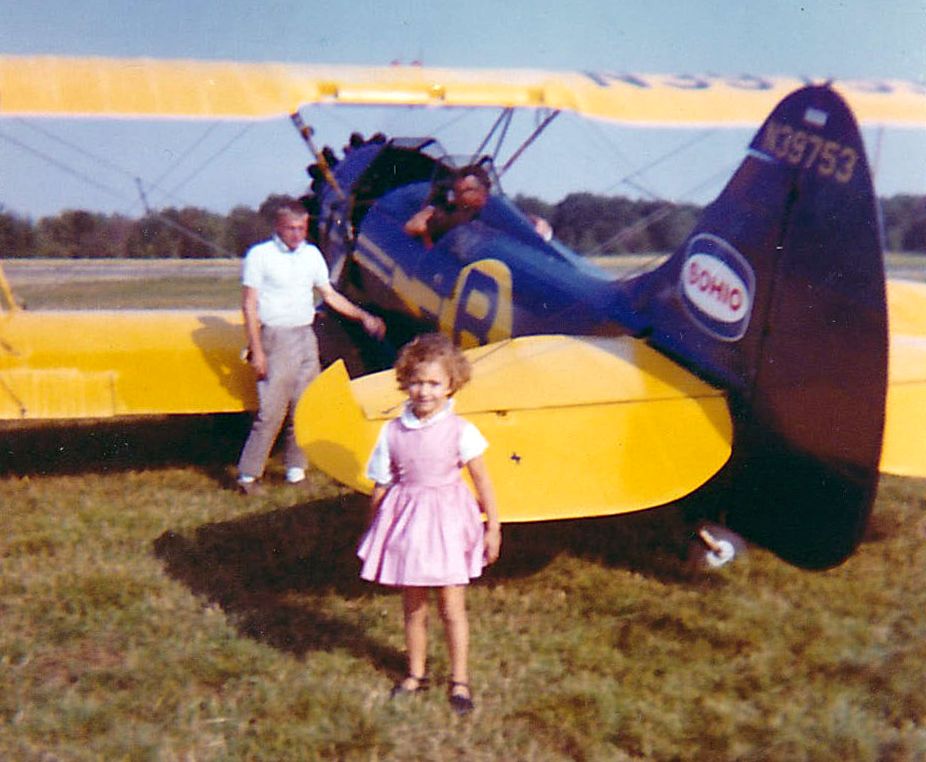
A summer 1964 photo of N39753, a 1942 Waco UPF-7, serial #5886, part of Barnhill's Air Circus at Chagrin Falls Airport.
Carl Denk recalled, “I started flying at Chagrin Falls Airport 7/22/65 in a J-3 with my first flight in N6013H.
Don Hein tested me for my Private [Pilot's License] 10/30/65 in PA-18 N1650P.
An interesting thing happened. The Omnigator between my knees quit working.
Don loosened his seat belt in the back seat & leaned over my shoulder to play with the radio.
Of course that big shift in center of gravity, caused a nose down condition, to which I responded correctly with a firm pull back on the stick.
Well, you know that plane as was typical, was setup with dual controls including a rear control stick, which met with Don's groin smartly!
Don sat back down, and announced that he had seen me navigate the VOR before, and I should proceed direct to the airport, where I received my Private. :)”
Carl continued, “The tree(s) at the Southwest end of the runway were planted there by the feuding owner.
In the middle of a night, the trees were cut down. I don't think anyone was every arrested for the deed.
Shortly after I landed a Navion there, a little low over the former tree site, added some power.
When I got to the office, there had been a phone call of a noisy airplane.”
The northeast/southwest runways at Chagrin Falls Airport was apparently paved at some point between 1962-66,
as the 1966 OH Airport Directory (courtesy of Chris Kennedy) depicted in as a 2,000' bituminous strip.
Don Hein was part owner & manager of Chagrin Falls Airport,
and was described as a stickler for all of the planes to be fully functional.
Bill Pine was the chief pilot at Chagrin Falls Airport.
Rick Boswell recalled, “I began flight instruction at Chagrin Falls / Horns Flying School in 1966 while a PhD graduate student at Case Western Reserve University.
Don Hein was the owner/manager, with Grace Parks handling scheduling & other office duties.
I flew with several instructors while working on my private certificate, with most of my dual with Richard (Dick) Molnar;
we started in a Piper Colt but soon switched to a Cessna 150 as I was thinking about eventually owning a Cessna 172.
An hour in the C150 went for $12 solo & $14 dual, with 80 octane avgas at 32 cents/gallon. Don Hein kept a close eye on things.
One day while mowing the grass, he noticed that I was not using flaps while in the pattern practicing landings,
as I had been advised by my instructor not to use flaps for crosswind landings.
He motioned to me to taxi in, jumped in the plane with me, and proceeded to chew me out royally (as Don could do with great proficiency)
and then proceeded to fly with me until he was happy with my landings.”
Rick continued, “In the early Spring of 1967 I was working in the pattern & had just landed on Runway 24
and turned around to back-taxi as there was no paved taxiway back to the opposite end.
Part way down the runway, I noticed another aircraft close in on approach to 24 & decided to taxi off the runway to allow this aircraft to land.
I didn’t count on the soft ground which resulted from recent Spring rains & promptly got stuck in the mud.
Don had to come out with his tractor to pull me out - a bit embarrassing, and my most serious 'incident' in 50 years (and counting) of flying.
One instructor at Horns’s taught me something I have never forgotten.
Talking about the C150 we were flying, he said, 'This thing will kill you if you let it.'
He was not trying to scare me but, rather, to motivate an appropriate aviation safety mindset. It worked!
Rick continued, “Horn’s was perhaps ahead of its time in that the school had a simulator on premises & used this for instrument training.
This sim appeared to be a classic 'Blue Box' Link Trainer, and while primitive by today’s standards, I found it helpful for instrument basics.
Chagrin Falls / Horn’s will always have a special place in my aviation memories.”
Bill Twyman recalled, “I had gotten my private [pilot's license] from Don Hein several years earlier & had been flying anything I could get my hands on.
I finally was able to finish up with getting my CFI [Certified Flight Instructor rating] and approached Don in late 1967 about an instructor slot at Chagrin.
He hired me & I worked part-time during school at Kent State University knowing that I was 1A & going in to the Navy as soon as I graduated, which was set for August 1969.
I had been flying with John Schofield who drove out from Shaker Heights. John was not just good, but a great student.
He had about 8 hours (like I had when I soloed) & I knew he was ready to solo, but that day 4/18/68, was crappy with low ceilings, drizzle & cool temperatures.
John had had a knee injury & had recently had a knee operation, so he would preflight the C-150 & get in, and I would set his crutches in the office & off we would go into the wild blue.”
Bill continued, “This particular day, I felt we could stay visual in the pattern so we just did touch & goes to keep him sharp.
On the last pass, I decided to test his mettle with a simulated forced landing, so I pulled out the carb heat & throttle while on crosswind just west of Chagrin Falls.
We were over a large, freshly plowed, soggy farm field. That field is still there with an electric sub-station on the edge of the field.
John circled down & was set up nicely for the field when I decided to take it for the go around.
Unfortunately, what you don't know can & often will bite you in the butt.
I had almost all my previous flying in Pipers & was new to Cessnas where you have to keep the exhaust manifold warm to keep heat to the Carb.
When I pushed in the throttle, there was no engine response.
As I had the plane, and we were approaching a tree, I elected to bank right to miss the tree & the right wing caught the ground, cartwheeling us.”
Bill continued, “John saw it coming & braced, so only got minor cuts on his face from plexiglass.
I had my hands on the control & throttle, so ate the instrument panel & took a nap for a while as John pulled me out the left door & to the end of the wing.
Fortunately, there was no fire, and we both recovered quickly. The airplane N2272J.
It wasn't until the next day that I got a copy of the Cleveland Plain Dealer with the story line,
'Son of prominent Schofield Family injured in plane crash!' OMG! I had no idea he was prominent anything. His dad owned the Schofield building at 9th & Euclid.
The best part of the story is that after I had been home for a couple of days, Don Hein called me at home.
I was not scared to talk to him, but I did expect to be told not to come back to work.
Instead, after he inquired about my condition, his ONLY question to me was, 'When are you coming back to work?'
What a guy! He could be very gruff, at times, but that told me he had a heart of Gold.
Actually, after that I did have a few dates with his daughter & have a huge respect for Don.”
Bill continuedm, “In October 1969 I left to go to the Navy Officer Candidate School in Pensacola & entered Navy Flight Training for jets.
I finished & received my Navy Wings in late 1970 & was offered a spot being a Navy jet Instructor as a plowback at NAS Kingsville, TX flying TA-4J Skyhawks.
In 1971 or 1972, my wife's father died in Cleveland, so I took a student on a cross country to see her at Columbus.
On Sunday, a clear & beautiful day, we left & I received permission from ATC to do a simulated approach to Chagrin Falls Airport, in a Navy TA-4J,
where I couldn't go slower than about 150 kts to keep from falling out of the sky, full flaps & gear down.
I asked ATC to call the office to inform those in the pattern I would be coming through.
As I left the VOR inbound, I was hoping everyone would be clear of the pattern, and they were.
At least I didn't see anyone nearby. As I crossed Bell Street, I shoved it to full throttle & pitched the nose up about 15 degrees to start climbing.
OMG! That 2,400' runway disappeared almost immediately & I found myself over the farmhouse where the trees had been planted, with a jet engine at full throttle.
CLE center had precleared me to unrestricted climb to 10,000', at which point I headed for Grissom AFB in Indiana for some fuel.
Probably not the smartest thing to do, but Don LOVED IT! I didn't let the wheels touch ground, but we were within 50'.
About a year later, I stopped in for a visit & he couldn't stop talking about the farmer with the trees calling him & accusing Chagrin of flying jets out of their little 2,400' strip.
That was my last time there before the field closed, and my last time to see Don, Bill Pyne, Lyle, and the others.”
Bill Lipstreu recalled, "I was the Cessna salesman who frequented the airport,
but actually, I learned to fly there in the 1960s.
Bill Pyne was my flight instructor,
but I finished with Tina DeBlaey & Bill Pfarr in 1975, shortly after returning from college.
I then got a job with Cessna & based my factory demonstrator at Chagrin."
David Greenhut recalled, “The airport where I learned to fly... Chagrin Falls Airport (5G1).
I came to Chagrin Falls Airport because my Junior High School (Byron Junior High in Shaker Heights) had a flying club,
run by my mechanical drawing teacher, Richard Tappendon.
We met weekly to watch old WW II training films, and the highlight of our year was a Saturday field trip in June 1968 out to Chagrin Falls Airport
for our $5 'Introductory Flight' being offered at the time by Cessna.
The aircraft was a 100 hp Cessna 150 (N6967S), and the instructor was Dennis Churgovich, the CFI who soloed me later that summer.
Mr. Tappendon had a Luscombe 8A that he kept tied down there.
I took all my initial training in a J-3-C65 Piper Cub, N98029 (which was only $15/hour wet w/instructor!). I soloed on August 28, 1968.
Most but not all of the operations that summer were from the paved runways (6/24),
but occasionally we operated from the sod runway to get crosswind practice.
That was always sporty since you could not see the paved runway until just before you crossed it because of a swale at the southwest end of the field.
Of course, with no electrical system (this was before the days of handheld radios), we had no way of knowing if someone was taking off or landing except 'see & avoid'.”
David continued, “After my solo I 'graduated' up to the Cessna 150 so I could learn to use radios for navigation & communication.
Some of the 150s around at the time were N6967S, N60369, N6968S, N50928 and N7109S.
I also flew with Bill Pyne, Dave Lindsey, Chuck Migyanko, Nina Para & Bill Twyman.
I also recall some kind of feud the airport had with a neighboring farmer,
who would not allow the airport to trim some cypress trees on his property which blocked the departure end of Runway 24.
I believe they finally went to court over it.”
David continued, “Don Hein was the airport owner & FBO, assisted by a woman named Grace (perhaps his wife?) who did scheduling & answered the phones.
By the summer of 1969 we had pilot-controlled lighting for the rare night flight, triggered on 122.8 Mhz.”
An undated (circa 1961-79) photo by Roald Lutz “of the chief mechanic at Chagrin, Lyle Staffield, with his Dart.
He was always took very good care of all the planes at Chagrin.”
James Akers recalled that "I soloed there June 16, 1970.
One of my instructors was Bill Pyne.
The airport at the time had a concrete runway that was 2,400'.
There were also one or 2 sod strips & a hangar/office.
Don Hein was an FAA examiner & a great pilot."
Herbert Rosenthal recalled, “To me, coming back say in 1973 or maybe even later, it was like going back in time.
It had been 10 years or so since I had spent a lot of time there teaching part-time.
But yet the same chief pilot (Donald Hein); the same mechanic (Lyle); and the same secretary/bookkeeper (Grace) were there.
It was like going back in time & nothing had changed.”
John Blosser recalled, "As a youngster, I lived in Chagrin Falls & frequently visited the airport.
I began to visit the airport in 1977, when I was about 12 years old.
I completed a private pilot ground school there during that year.
The airport's operator was Horn's Flying School; its owner was Horn & Hein Realty.
Don Hein was the airport manager.
The school had Cessna 150s & 172s as well as a 152 acquired in 1978.
One of the 150s was N19463, one of the Skyhawks was N19683.
I believe the 152 was N734RN or 737RN.
They also owned a J3 Cub which was painted in a bicentennial paint scheme.
The airport had FAA identifier 5G1.
It had an approximately 2,0000' paved Runway 6/24.
The runway was rather narrow & had some undulations in it.
It was on Bell Road just east of Route 306,
at the site of the current Kensington Greens housing development in South Russell.
I recall that at night, Flight Service would contact the South Russell Police
to come & turn on the runway lights if you needed them.
There was a large hangar at the northwest corner of the property
which had an office & pilot lounge/classroom attached to it.
There was a maintenance hangar a little east of it
and I believe some t-hangars further east of that."
John continued, "There were some really fine people associated with the airport.
Besides Don Hein, I remember instructors Bill Pyne, Al Kovar & Christine DeBlaey.
They had an excellent mechanic named Lyle
and a lineman named Andy Borsi who I believe became an aircraft & powerplant mechanic.
The local Cessna salesman was Bill Lipstreu. He frequented the airport.
There was Dennis Agin, a dentist who paid me to update his extremely overdue Jeppesen instrument approach charts,
and Bert Ragsdale, a very genteel man who owned a Cessna 172.
Reed Kinloch, a friend of my parents took me to the airport for the first time when he was a student pilot.
Harold & Bee Reiske were in my ground school class & usually gave me rides there.
Oakley Lawson owned a Cessna 182, N3360F.
He was always willing to answer my questions & pose more.
He was one of the few pilots (besides Tina DeBlaey) who my parents trusted to take me flying.
I still have the copy of Instrument Flying by Taylor that Oak gave me.
Several of the Chagrin Falls Airport regulars autographed it for me.
The people there kindled a lifelong love for aviation in me
and helped teach me many important lessons about life in the process.
I have lost touch with most of them, but I hope they know how special they all were & are to me."
Bill Lipstreu recalled, "Chagrin officially closed May of 1979.
I was the last airplane out.
I was still working for Cessna at the time & ended up moving the company airplane down to KSU Airport."
According to Bill Meyer, "I made a precautionary landing there in March, 1981 due to icing.
It was closed then although all the facilities were in good shape.
There was a Quonset type hangar on the North side.
For many years Horn's Flying School operated there, under Bill Horn.
The name remained on the hangar until it was razed.
Don Hein operated the school until the airport closed, I believe.
I also recall one or possibly 2 rows of T hangars to the northeast of the big hangar.
Runway 6/24 was paved & at least 2,400' as I recall, not much more.
There was also a sod strip North/South which was used very little.
An observant pilot can still drive down Bell Street,
and looking behind the houses on the North side see the what-used-to-be orange balls on the power lines behind the houses.
The development on the site is called Kensington Greens.
Great little airport, many pilots trained there, including my father in the late 1930's."
A 1979 photo by Roald Lutz “of the field just after it had closed.
The planes were gone, but the structures were still there.”
David Greenhut recalled, “I was disappointed when I went away to college to not be able to keep up my flying,
and when I came back to the Cleveland area years later was disappointed to see the airport gone & a housing development in its place.”
Ruth Mc Ilrath Cavanagh recalled, "When the place was sold by Hein's to become Kensington Green, I was sick about it.
I took my Super 8 movie camera & took a 360 degree shot of the old place.
I spent very much good time their as a child."
According to Hans Friedebach, “When the Chagrin Falls Airport closed,
the old Horn's Flying Service hangar steel structure was acquired by a local volunteer aviation history group.
It was intended to be re-erected at Ravenna, OH airport as part of a planned aviation museum.
The museum plans stalled when its financial backing fell through,
but not until the foundation for the Chagrin Falls hangar had been poured next to the completed 10,000 sq ft museum hangar.
The hangar structural steel was acquired by a Florida man
to be re-erected at an airfield he was planning in Florida.
His airfield plans fell through over regulatory approval problems.
I don't know whatever happened to the hangar structure.”
According to Hans Friedebach, “Horn's J-3 Piper Cub with the bi-centennial paint job
eventually turned up in Fortuna, on the northern California coast near the Oregon border.
It has been restored to Cub Yellow & is owned by Charlie Jones, A&P & USFS Fire Bomber pilot
who gave me a ride in it during a visit there in the 1990s.”
Herbert Rosenthal recalled, “For many years an airway intersection was located right over the former airport
which one would use as a gate to get to Burke Lakefront or County Airport.”
A 4/14/94 USGS aerial photo showed no trace remaining of Chagrin Falls Airport,
with homes of the Burlington Green housing development covering the site.
The 1996 USGS topo map still depicted the airfield, labeled simply "Landing Strip",
even though a photo from 2 years prior showed the site covered by a housing development.
It depicted a single 2,200' northeast/southwest runway,
along with several buildings (hangars?) along the north side of the field.
Steve Krieger recalled, “I loved that old airfield, and it probably instilled in me the love that I still have for aviation.
I was sad that, when I revisited the area in about 1999 that the old place had been taken over by tract homes.
A large part of my childhood lies underneath those foundations!!”
A 2014 aerial photo showed no trace remaining of Chagrin Falls Airport.
The site of Chagrin Falls Airport is located southeast of the intersection of Route 306 & Bell Road.
Thanks to Bill Meyer (who flew out of Chagrin Falls Airport) for pointing it out.
____________________________________________________
Since this site was first put on the web in 1999, its popularity has grown tremendously.
That has caused it to often exceed bandwidth limitations
set by the company which I pay to host it on the web.
If the total quantity of material on this site is to continue to grow,
it will require ever-increasing funding to pay its expenses.
Therefore, I request financial contributions from site visitors,
to help defray the increasing costs of the site
and ensure that it continues to be available & to grow.
What would you pay for a good aviation magazine, or a good aviation book?
Please consider a donation of an equivalent amount, at the least.
This site is not supported by commercial advertising –
it is purely supported by donations.
If you enjoy the site, and would like to make a financial contribution,
you
may use a credit card via
![]() ,
using one of 2 methods:
,
using one of 2 methods:
To make a one-time donation of an amount of your choice:
Or you can sign up for a $10 monthly subscription to help support the site on an ongoing basis:
Or if you prefer to contact me directly concerning a contribution (for a mailing address to send a check),
please contact me at: paulandterryfreeman@gmail.com
If you enjoy this web site, please support it with a financial contribution.
please contact me at: paulandterryfreeman@gmail.com
If you enjoy this web site, please support it with a financial contribution.
____________________________________________________
This site covers airfields in all 50 states.