
Abandoned & Little-Known Airfields:
South Carolina, Western
© 2002, © 2016 by Paul Freeman. Revised 11/27/16.
This site covers airfields in all 50 states: Click here for the site's main menu.
____________________________________________________
Please consider a financial contribution to support the continued growth & operation of this site.
Ashley Airfield (revised 11/15/15) - Campobello Airport (revised 11/27/16) - Greenwood Municipal Airport (1st location) (revised 11/27/16)
Greenwood Municipal (2nd location) / Johnson Field / Chinquapin Airport (revised 11/27/16) - Hawthorne School of Aeronautics (revised 11/15/15)
Palmetto Airport / Twin City Airport (revised 7/27/14)
____________________________________________________
Campobello Airport, Campobello, SC
35.074, -82.218 (Northwest of Columbia, SC)
Campobello Airport, as depicted on the July 1960 Charlotte Sectional Chart.
Photo of the airport while open is not available.
The date of establishment of this small general aviation airport has not been determined.
Campobello Airport was not depicted on the January 1955 Charlotte Sectional Chart.
The earliest depiction which has been located of Campobello Airport was on a 1955 aerial photo,
which depicted it as having 2 unpaved runways.
According to Alex Nelon, “The airport was used, it is rumored, to bring illegal whiskey in & take it out during the early to mid-20th century.”
The July 1960 Charlotte Sectional Chart depicted Campobello Airport as having a 2,000' unpaved runway.

The 1961 USGS topo map depicted Campobello Airport as having 2 unpaved runways.

The last aeronautical chart depiction which has been located of Campobello Airport was on the October 1968 Charlotte Sectional Chart.
It depicted Campobello Airstrip as having a 1,900' unpaved runway.

The last map depiction which has been located of Campobello Airport was on the 1986 USGS topo map.
It depicted Campobello Airstrip as having a single northwest/southeast runway.
Campobello Airport was evidently closed (for reasons unknown) at some point between 1968-94,
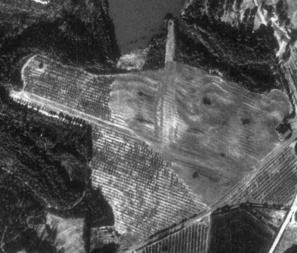
as a 1994 aerial photo showed the site had returned to cultivation, although the runways were still recognizable.

The outline of both of Campobello's former runways were still recognizable in a 2015 aerial view.
The site of Campobello Airport is located west of the intersection of Jug Factory Road & State Road South 42-773.
Thanks to Alex Nelon for pointing out this airfield.
____________________________________________________
Palmetto Airport / Twin City Airport, Batesburg, SC
33.874, -81.51 (Southwest of Columbia, SC)
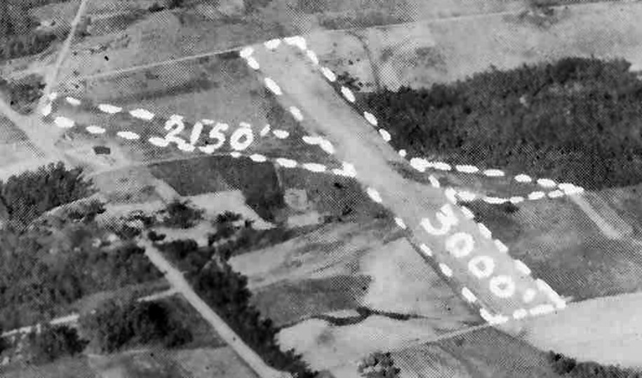
An undated aerial view looking north at Twin City Airport from a circa 1957 SC Airport Directory (courtesy of Don Fraser).
This small general aviation airport was evidently established at some point between 1945-62,
as it was not yet listed among active airfields in the 1945 AAF Airfield Directory (courtesy of Scott Murdock).
The earliest depiction which has been located of the Palmetto Airport was an undated aerial view from a circa 1957 SC Airport Directory (courtesy of Don Fraser).
It depicted Twin City Airport as having 2 unpaved runways, and listed the owner as Church of God.

A 2/7/62 USGS aerial view depicted Palmetto Airport as having 2 unpaved runways, with a hangar & the campground buildings along the west side.
No aircraft were visible on the field though.
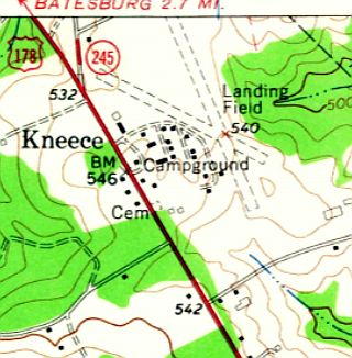
The 1964 USGS topo map depicted 2 unpaved runways, labeled simply as “Landing Field”,
with a campground with a large number of buildings adjacent to the west side.
Jim Fender recalled, “When I was a kid I would ride my bicycle to this airport to peer over the fence at the airplanes.
My Mother beat my behind for riding across the 2-lane highway to get there.
I think the name was either Twin City or Twin Cities Airport.”

Palmetto Airfield apparently lost its crosswind runway at some point between 1964-82,
as the 1982 USGS topo depicted 3 long buildings having been constructed over the eastern end of the former 2nd runway.

The entire length of Palmetto's runway was still evident in a 1994 USGS aerial photo,
but there was no sign of any recent aviation usage.

A circa 2010 aerial view looking west at the Palmetto / Twin City hangar.

An 11/24/11 aerial view showed that the northern end of Palmetto's north/south runway was still recognizable,
but the southern end had been overgrown with trees.

A 5/27/14 photo by Jim Fender looking east at the hangar marked “Twin City”.
The site of Palmetto Airport is located east of the intersection of Angelwings Road & Fairview Road.
Thanks to Jim Fender for pointing out this airfield.
____________________________________________________
Ashley Airfield, Honea Path, SC
34.447, -82.366 (West of Columbia, SC)

Ashley Airport, as depicted on the October 1948 Charlotte Sectional Chart (courtesy of Chris Kennedy).
This small general aviation airport was evidently established at some point between 1946-48,
as it was not yet depicted at all on the April 1946 Charlotte Sectional Chart (according to Chris Kennedy).
The earliest depiction which has been located of the Ashley Airport
was on the October 1948 Charlotte Sectional Chart (courtesy of Chris Kennedy).
It depicted Ashley a commercial/municipal airport.

The earliest photo which has been located of the Ashley Airport was an undated aerial view looking north from a circa 1957 SC Airport Directory (courtesy of Don Fraser).
It depicted Ashley as having 2 unpaved runways, and described it as a private field operated by C.P. Ashley.
A 1970 USGS aerial photo depicted Ashley as having 2 unpaved runways.

The 1971 USGS topo depicted the “Ashley Airfield”
as having two unpaved runways, with two small buildings on the northwest side of the field.
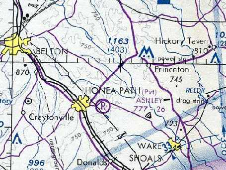
The last aeronautical chart depiction of the Ashley Airport which has been located
was on the April 1980 Atlanta Sectional Chart (courtesy of Chris Kennedy).
It depicted Ashley a private field, with a 2,600' unpaved runway.
In the 1994 USGS aerial photo, the Ashley Airfield appeared to be maintained in good condition,
with both grass runways appearing to be well-maintained.
What appeared to be a hangar was located at the northwest end of the northwest/southeast runway.
The Ashley Airport was no longer depicted at all
on the September 1996 Atlanta Sectional Chart (according to Chris Kennedy).
Bo Bowman reported in 2005, “It is 2 crossing grass strips - still well maintained
and one newer hangar, and some older small buildings -
it looks like a radio-control [model airplane] club uses one of the runways periodically.
I did a low pass & then landed there in my Piper Archer Thanksgiving weekend - nice smooth turf.
However, it has not been on any sectional over recent years I am told - although it is used.”

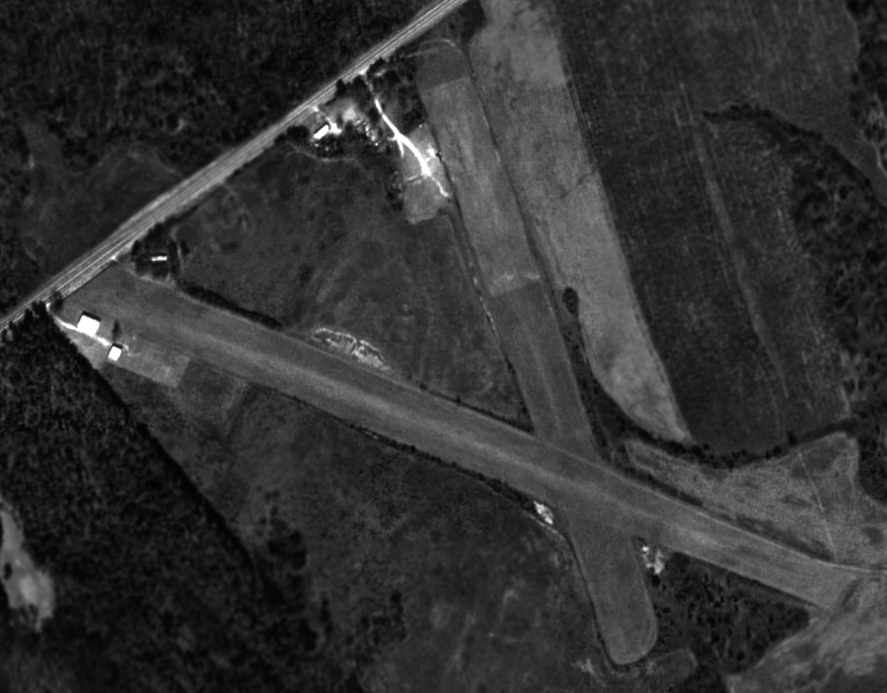
A 12/17/05 aerial photo by Bo Bowman, looking west at Ashley Airport.
No airfield in Honea Path was listed among the FAA Airport/Facility Directory data as of 2005.

A 2014 aerial view looking southeast at Ashley Airport shows the airfield appearing to have been reopened (?),
with several new hangars at the bottom-right, and the northwest/southeast runway having been extended toward the southeast.
Ashley Airfield is located east of the intersection of Route 252 & Corbin Road.
____________________________________________________
Greenwood Municipal Airport (1st location), Greenwood, SC
34.21, -82.17 (West of Columbia, SC)

A 1939 aerial photo of the first Greenwood Municipal Airport (taken from aerial photos at the County courthouse by Bo Bowman).
The first municipal airport for the town of Greenwood was located on the north side of town.
According to Bo Bowman, “The first Greenwood Municipal Airport was dedicated on the evening of 6/19/29.
Interestingly, on that particular day, this event took second billing to the Georgia & Florida (G & F) Railroad.
This day was also 'G & F Day', celebrating the arrival of this railroad as the 5th railroad through the City of Greenwood.
However, the rest of the week, attention was centered on the airport,
and stunt flying & parachuting exhibitions performed by the 'Charlotte Flying Circus'.
The airport was located on Power House property,
just off Hodges Road”, which later became known as Montague Avenue.
Bo continued, “During the week following the airport’s dedication,
the Charlotte Flying Circus continued to perform & to sell airplane rides.
Featured in the performances were airmail pilot George Shealy, pilot Clyde White, and parachutist Dick Hunter.
George Shealy flew his 'Cabin Monoplane', a Curtiss Robin,
which was a new & advanced model airplane at that time, and quite a treat for Greenwood residents to see.
Clyde White flew a Waco 10 biplane, and Dick Hunter excited the spectators with 1,000 foot 'delayed jumps'”.
There was no airport listed in Greenwood at all
in The Airport Directory Company's 1933 Airport Directory (according to Chris Kennedy)
nor in the 1934 Department of Commerce Airport Directory (according to Chris Kennedy),
nor depicted on the May 1936 Charlotte Sectional Chart.
Perhaps this field was simply overlooked due to its minor size.
A replacement Greenwood Municipal Airport was constructed on the west side of the town during the 1935-36 time period,
after which presumably the original Greenwood Municipal Airport was closed.
The earliest depiction which has been located of the first Greenwood Municipal Airport
was a 1939 aerial photo (taken of photos in the County courthouse by Bo Bowman).
It depicted the field as having a single unpaved northeast/southwest runway.
There did not appear to be any buildings associated with the field.
The first location of the Greenwood Municipal Airport was not depicted on the October 1940 Charlotte Sectional Chart,
only the replacement Greenwood Municipal Airport on the west side of the town.
By the time of a 5/14/51 USGS aerial photo,
no recognizable traces appeared to remain at the site of the first location of Greenwood Municipal Airport,
which had been covered with houses.
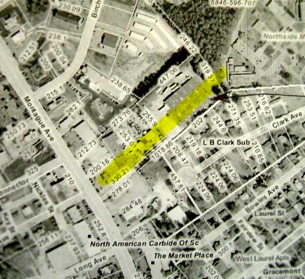
The location of the runway of the first Greenwood Municipal Airport,
overlaid by Bo Bowman over a 2003 aerial photo on a GIS diagram.
The site of the original Greenwood Municipal Airport is located northeast
of the intersection of Montague Avenue & Roseland Drive.
____________________________________________________
Greenwood Municipal Airport (2nd location) / Johnson Field / Chinquapin Airport,
Greenwood, SC
34.19, -82.21 (West of Columbia, SC)
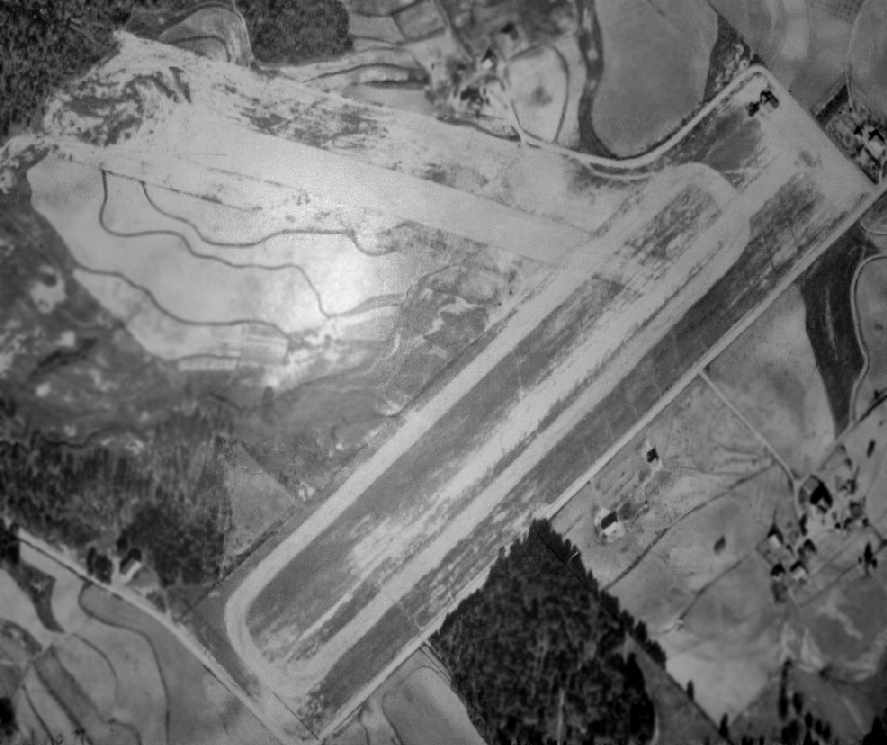
A 1939 aerial photo of the 2nd location of the Greenwood Municipal Airport (taken from aerial photos at the County courthouse by Bo Bowman).
According to Bo Bowman, the original Greenwood Municipal Airport was replaced
“by a new airport on the west end of the city just off of Chinquapin Road.
This new Greenwood airport, first referred to as Chinquapin Airport & later as Johnson Field,
was constructed with funds provided by the Works Progress Administration in the 1935-36 time period
and had two grass or dirt runways, reportedly 2,300' & 2,000' long.
Earl 'Bunker' Smith owned a 40-horsepower Piper Cub in which he gave rides & flying lessons.
A group of 6 young men pooled their funds, bought Smith’s airplane,
took flying lessons, and built the first hangar.
They were responsible for the first operations at this airport.
Four of the men in this group were Ed Seymour (who would later become a member of the County Airport Commission),
Truman Witt, Myers Page, and Butler Culbertson.
Other airplane enthusiasts at that time were B. F. McKellar, Jack Whatley, James Telford, and Homer Tribble.
After Bunker Smith left the field, Luther Johnson came to be the next flight instructor & opened Johnson Air Services.
It was after this the field became known as Johnson Field.”
The earliest directory reference which has been located of the Greenwood Municipal Airport
was in The Airport Directory Company's 1937 Airport Directory (courtesy of Bob Rambo).
It described the field as being located 2 miles west of the town, and being 35 acres in size.
It was said to have 2 sod runways in a “Y” shape, measuring 2,300' east/west & 2,000' northwest/southeast.
A note remarked however, “This field under construction but usable.”
The Airport Directory Company's 1938 Airport Directory (according to Chris Kennedy)
described the field in the same manner.
The earliest depiction which has been located of the 2nd location of the Greenwood Municipal Airport
was a 1939 aerial photo (taken of photos in the County courthouse by Bo Bowman).
It depicted the field as having two unpaved runways,
oriented northeast/southwest & northwest/southeast.
A small building (or set of buildings) appeared to be located on the east side of the field.
According to Bo Bowman, “In 1940 a government-sponsored Civilian Air Training course was begun at this airport.
The first class had approximately 30 students including young men & young women.
Tracy Jackson taught ground instruction & Luther Johnson gave flying lessons.
These classes were continued into the early 1940s.”

The earliest chart depiction which has been located of the 2nd location of Greenwood Municipal Airport
was on the October 1940 Charlotte Sectional Chart.

The only photo which has been located showing aircraft at Johnson Field was a circa late 1944 picture of one of the Erskine pre-cadet screening classes (courtesy of Jonathan Westerling).
Bo Bowman observed, “Instructors are kneeling & some standing in the front row.
A fleet of about 15 airplanes, mostly J-3 Cubs, would be stored at night tails-up in Luther Johnson's hangar.
This hangar was eventually moved to the Greenwood County Airport & remains there in use today [2006].”
According to Bo Bowman, “In the 1944-45 time period, working with Luther Johnson,
the Army Air Service hired a staff of contracted instructors to provide preliminary screening instruction
to potential air cadets bused in from nearby Erskine College.
This was part of an Army program to reduce the 'washout' rate being experienced at the major Air Cadet flying schools.
According to Jack Northrup (one of the former instructors),
there was a staff of about 10-15 instructors, and each class had about 60 students.”
The 1945 AAF Airfield Directory (courtesy of Scott Murdock) described Greenwood Municipal Airport
as a 52 acre T-shaped property within which were 2 sod runways, measuring 2,350' northeast/southwest & 2,000' WNW/ESE.
The field was said to have a single 60' square steel hangar,
was owned by Greenwood County & the City of Greenwood, and operated by private interests.
According to Bo Bowman, “The Chinquapin Airport property was sold in 1948.
The funds from the sale of the property went towards a new terminal building
at the new Greenwood County Airport (formerly Coronaca Army Air Field).
Two hangars were moved to the new airport.”

The 1949 USGS topo map depicted the 2nd location of the Greenwood Municipal Airport
as having 2 paved runways, a taxiway, and several small buildings, labeled simply as “Airport”.
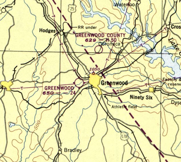
The last aeronautical chart depiction which has been located of the 2nd location of Greenwood Municipal Airport
was on the February 1950 Charlotte Sectional Chart.
It depicted the 2nd location of Greenwood Municipal Airport as having a 2,400' unpaved runway.
Note that it also depicted the new “Greenwood County” Airport (north of the town), which would eventually replace the older airport.
The last depiction which has been located of the 2nd location of the Greenwood Municipal Airport was a 1/26/51 USGS aerial view.
Housing construction had not yet begun – with the runways still remaining clear.
The hangars on the northeast side of the airport had been removed.
According to Bo Bowman, “A housing development was constructed along both runways.”
By the time of the August 1954 Charlotte Sectional Chart (according to Chris Kennedy),
the 2nd location of the Greenwood Municipal Airport was no longer depicted.
By the time of a 1972 USGS aerial photo, no recognizable traces appeared to remain at the site of the 2nd location of Greenwood Municipal Airport,
with houses covering the site.

The location of the runways of the 2nd location of the Greenwood Municipal Airport,
overlaid by Bo Bowman over a 2003 aerial photo on a GIS diagram.
According to Bo, “One runway is now Marietta Drive, and the other is Westgate Drive.”

A 2013 aerial view looking north at the 2nd location of the Greenwood Municipal Airport
shows that the orientation of the 2 runways is still recognizable in the streets which were built over the runways.
____________________________________________________
Hawthorne School of Aeronautics, Orangeburg, SC
33.42, -80.85 (South of Columbia, SC)
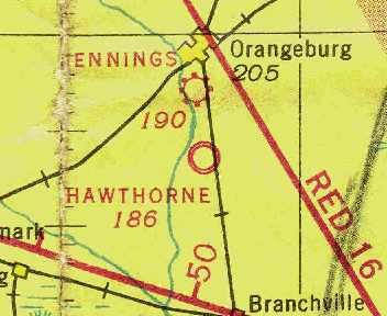
The Hawthorne School of Aeronautics airfield,
as depicted on the September 1942 14M Regional Aeronautical Chart (courtesy of Chris Kennedy).
The Hawthorne School of Aeronautics was a civilian flying school
which was chosen by the Army Air Corps in 1940 to provide primary flight training for its pilots.
This training commenced in 1941, using the Boeing PT-17 Stearman biplane.
The date of construction of Hawthorne's airfield is unknown.
No indication has been found that it existed prior to WW2 -
it evidently was built by the Hawthorne School of Aeronautics at the beginning of their contract.
The Hawthorne airfield was not yet depicted at all on the November 1941 Savannah Sectional Chart (according to Chris Kennedy).
The earliest depiction of the airfield which has been located
was on the September 1942 14M Regional Aeronautical Chart (courtesy of Chris Kennedy).
It depicted Hawthorne as a military airfield.
The Hawthorne airfield was not depicted at all on the 1943 USGS topo map.

The earliest photo which has been located of the Hawthorne School of Aeronautics was a May-June 1943 photo of Class 43J in front of a row of PT-17 Stearman trainers.

The September 1943 Savannah Sectional Chart (courtesy of Chris Kennedy)
depicted Hawthorne as a commercial or municipal airport.
The president of Hawthorne was Beverly "Bevo" Howard,
who had learned to fly at the age of 16.
The military designation of the Hawthorne school was the 2162nd AAFBU.

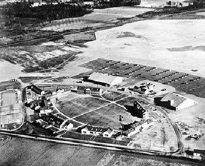
A circa 1940s picture of the buildings of the Hawthorne School of Aeronautics (courtesy of George Miller).

A circa 1940s sketch of the Hawthorne School of Aeronautics at Orangeburg (courtesy of John Lees).
John reported, “My father [Charles Lees] learned to fly at the Hawthorne School of Aeronautics in WW2.
His first solo flight occurred there.”
The sketch depicted the facility as consisting of a group of housing buildings surrounding an oval-shaped grass area at the northern end of the property.
A pair of hangars sat just to the south,
and just to the south of the hangars was a large paved ramp area, on which were a large number of aircraft.
A large open grass area to the south of the ramp evidently constituted the flying field
(apparently there were no paved runways).

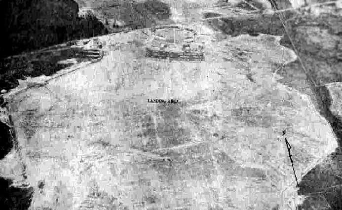
A circa 1943-45 aerial view looking north from the 1945 AAF Airfield Directory (courtesy of Scott Murdock)
depicted at Hawthorne Field as consisting of an open grass area with a complex of buildings on the north side.
The directory described Hawthorne a 531 acre rectangular property within which was a sod all-way field, measuring 5,230' northeast/southwest.
The field was said to have 2 steel hangars, measuring 180' x 140' & 140' x 120'.
Hawthorne Field was described as being owned by the City of Orangeburg, to be operated by private interests,
and to have 3 auxiliary fields: Auxiliary Field #1 (Jennings Airport) 3 miles north, Auxiliary Field #2 (Hagood Field) 9 miles east,
and Auxiliary Field #3 (Kennedy Field) 10 miles west.

A 1943 photo of Thomas Harnish (2nd from right) & 4 other fliers in front of a Stearman at the Hawthorne School of Aeronautics.
During the Second World War, Hawthorne trained 5,924 military pilots at Orangeburg,
including more than 2,000 French Air Force students.
For his leadership, Bevo Howard was presented the French Air Force Wings,
the coveted French Medaille de L'Aeronautique,
and later the Ordre National de la Legion D'Honneur for his pilot training & accomplishments as an aerobatic flyer.
A 1944 aerial view looking southeast at the Hawthorne School of Aeronautics, showing a ramp with dozens of trainers.

A 1944 photo of an unidentified pilot in a PT-17 Stearman at the Hawthorne School of Aeronautics.
The Hawthorne School of Aeronautics ceased operations at Orangeburg at the end of WW2,
but went on to continue operations at Jacksonville FL & Moultrie GA.
The firm eventually became the large Piedmont-Hawthorne chain of aviation Fixed Base Operators,
which continues in business as of 2003.
It is not known if the former Hawthorne airfield at Orangeburg was ever reused after WW2.
It was definitely abandoned by 1949,
as it was not depicted at all on the 1949 Savannah Sectional Chart (according to Chris Kennedy)
or subsequent Sectional Charts.
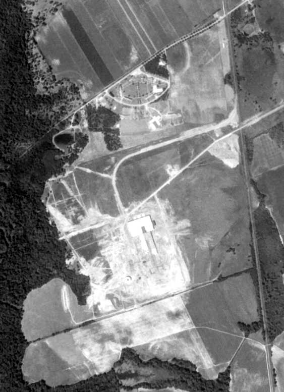
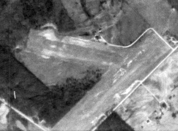
A 9/1/64 USGS aerial photo showed the distinctive layout of the Hawthorne flying school buildings at the north end.
Some kind of large industrial building had been constructed over the middle portion of the airfield.

A plaque honoring the Hawthorne School of Aeronautics.
The 2 hangars from the flying school were relocated at some point to the Orangeburg Municipal Airport (3 miles north),
at which there is also an excellent historical display of the activities of the Hawthorne school.
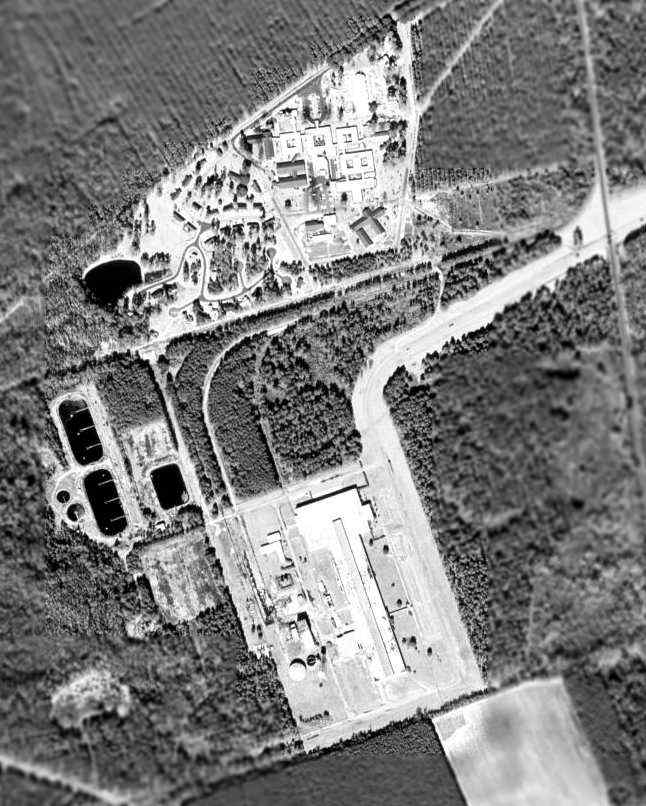
In the 1994 USGS aerial photo,
the area of the former flying field was occupied by what appears to be some kind of large industrial building,
along with wastewater ponds & a railroad spur leading on the to the property
from the line of the Southern Railroad which runs along the east side of the site.

A 2002 photo by George Miller of the remains of the asphalt aircraft ramp area at Orangeburg.

A 2002 photo by George Miller of a historical marker erected in 1991
by the WW2 Hawthorne Pilot Training Association & French pilot association.
According to George Miller,
the site of the housing area at the northern end of the former airfield is currently used as a Methodist Home.
The only recognizable remains of an airfield are some minor hardstands.

A 2014 aerial view showed no recognizable trace of the Hawthorne School of Aeronautics.
The site of the Hawthorne School of Aeronautics is located at the western terminus of State Route S38 57, west of Route 21,
five miles south of Orangeburg.
Thanks to George Miller for pointing out this airfield.
See also: (in French) http://perso.wanadoo.fr/patrice.laverdet/html/cfpna_hawthorne.htm
____________________________________________________
Since this site was first put on the web in 1999, its popularity has grown tremendously.
That has caused it to often exceed bandwidth limitations
set by the company which I pay to host it on the web.
If the total quantity of material on this site is to continue to grow,
it will require ever-increasing funding to pay its expenses.
Therefore, I request financial contributions from site visitors,
to help defray the increasing costs of the site
and ensure that it continues to be available & to grow.
What would you pay for a good aviation magazine, or a good aviation book?
Please consider a donation of an equivalent amount, at the least.
This site is not supported by commercial advertising –
it is purely supported by donations.
If you enjoy the site, and would like to make a financial contribution,
you
may use a credit card via
![]() ,
using one of 2 methods:
,
using one of 2 methods:
To make a one-time donation of an amount of your choice:
Or you can sign up for a $10 monthly subscription to help support the site on an ongoing basis:
Or if you prefer to contact me directly concerning a contribution (for a mailing address to send a check),
please contact me at: paulandterryfreeman@gmail.com
If you enjoy this web site, please support it with a financial contribution.
please contact me at: paulandterryfreeman@gmail.com
If you enjoy this web site, please support it with a financial contribution.
____________________________________________________
This site covers airfields in all 50 states.