Abandoned & Little-Known Airfields:
Texas - Eastern Austin area
© 2002, © 2016 by Paul Freeman. Revised 11/27/16.
This site covers airfields in all 50 states: Click here for the site's main menu.
____________________________________________________
Please consider a financial contribution to support the continued growth & operation of this site.
Cuero Field / Brayton Flying Field (revised 11/27/16) - Guenther Field (revised 6/21/15) - Lite-Flite Austin Airfield (added 3/12/16) - Tim's Airpark / Austin Executive (revised 4/12/14)
____________________________________________________
Lite-Flite Austin Airfield, Manor, TX
30.348, -97.49 (East of Austin, TX)
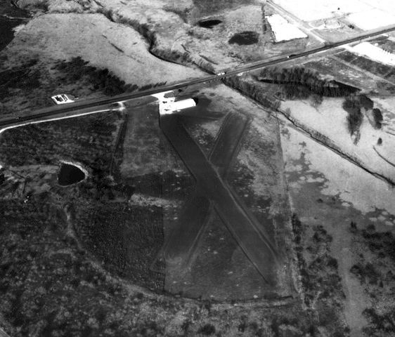
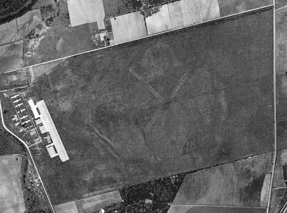
A circa 1984-85 aerial view looking north at Lite-Flight Austin Airfield, taken by the reconnaissance camera of an Air Force RF-4 Phantom (courtesy of John Melvin).
This small airfield was operated by the Lite-Flight Ultrasport ultralight aircraft company.
The date of establishment of the Lite-Flight Austin Airfield has not been determined.
The earliest depiction which has been located of this airfield was a circa 1984-85 aerial view (courtesy of John Melvin).
John recalled, “It was taken from an RF-4 using its reconnaissance camera system by a neighbor of mine who was a pilot out of Bergstrom AFB.
He had mentioned the location in a briefing & it was requested that he get some photos as the site was near a low-level training area.”
It depicted Lite-Flight Austin Airfield as having 2 grass runways in an X-shape, with a building on the north side.
John Melvin recalled, “Lite Flite Austin... was a satellite operation of Lite Flite Katy.
I was working at Lite-Flite part-time assembling ultralights & flying as often as I could.
Some of us flew from there to Tim's Airpark & back on several occasions.”
No aeronautical chart depictions have been located of Lite-Flight Austin Airfield.
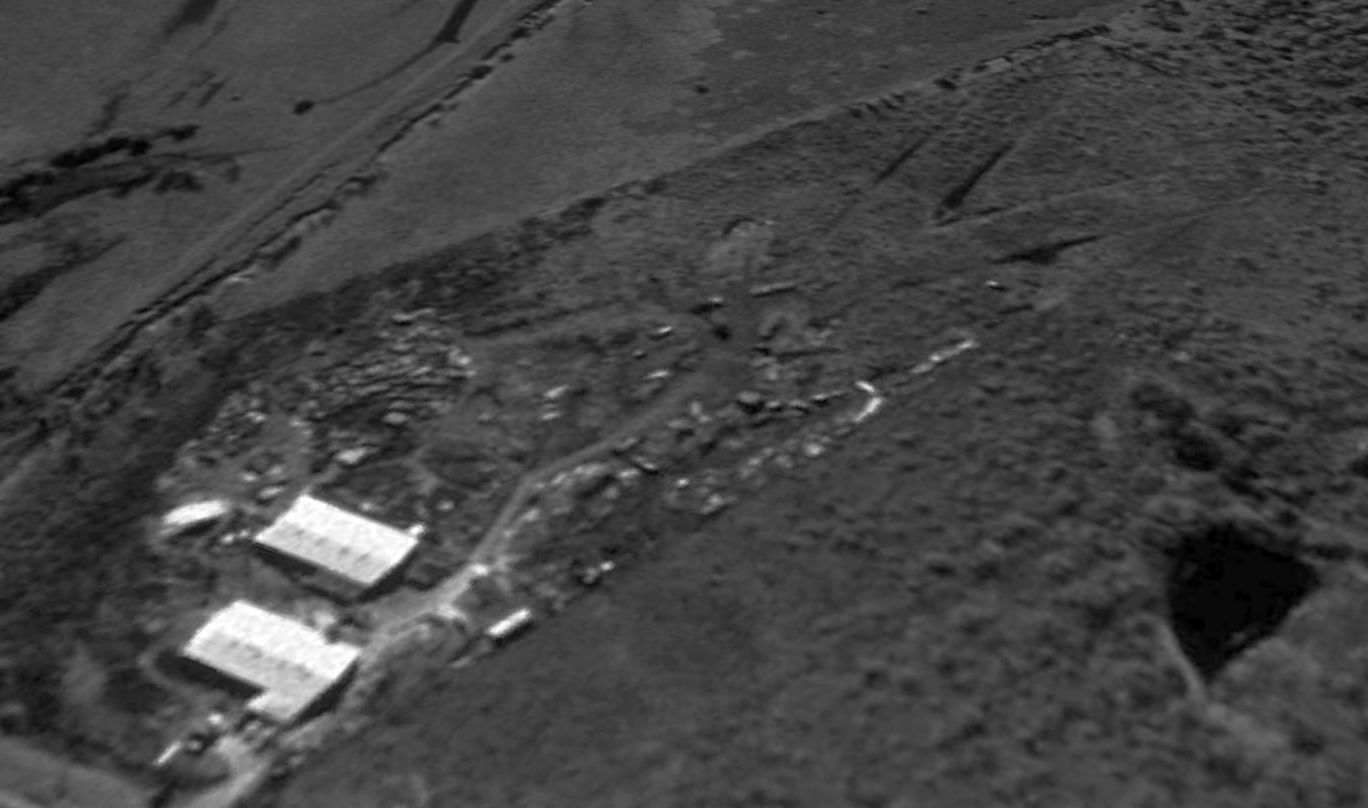
Lite-Flite Austin Airfield was evidently abandoned (for reasons unknown) at some point between 1984-95,
as a 1995 aerial view looking southeast showed the X-shape of the 2 runways was still recognizable but they were notably overgrown.
A second building had been added north of the runways at some point between 1989-95.
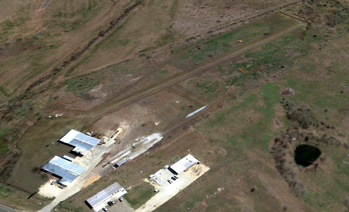
Lite-Flite Austin Airfield may have been reopened at some point between 1995-2011,
as a 2011 aerial view looking southeast showed what appeared to be a new unpaved runway, not reusing the previous runway alignment but instead running north/south.
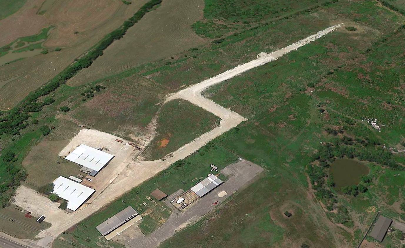
A 2015 aerial view looking southeast at the site of Lite-Flite Austin Airfield showed that the north/south runway appeared to have been partially paved at some point between 2011-2015.
The site of Lite Flite Austin Airfield is located southeast of the intersection of Route 290 & Old Kimbro Road.
Thanks to John Melvin for pointing out this airfield.
____________________________________________________
Guenther Municipal Airport / Guenther La Grange Airport, La Grange, TX
29.9, -96.9 (Southeast of Austin, TX)
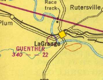
Guenther Municipal Airport, as depicted on the 1950 San Antonio Sectional Chart (courtesy of David Brooks).
The original airport for the town of La Grange was located adjacent to the southwest side of the town.
Guenther Municipal Airport was apparently established at some point between 1949-50,
as it was not yet depicted on the January 1949 San Antonio Sectional Chart (according to Chris Kennedy).
The earliest depiction of Guenther Municipal Airport which has been located
was on the 1950 San Antonio Sectional Chart (courtesy of David Brooks).
It was described as having 2 turf runways, with the longest being 2,200'.
The only photo which has been located showing the Guenther Municipal Airport while open was a 2/1/57 USGS aerial view,
which depicted Guenther as having 2 unpaved runways, with 1 small hangar at the north end.
By the time of the 1964 San Antonio Sectional Chart,
the primary runway at Guenther had been slightly lengthened, to 2,600'.
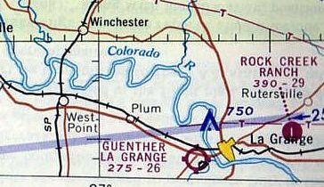
The 1966 Austin Sectional Chart (courtesy of John Price)
depicted Guenther La Grange as having a 2,600' unpaved runway.
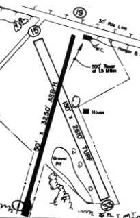
At some point between 1964-70, the primary runway at Guenther became a 3,350' asphalt Runway 1/19,
as depicted in the 1970 TX Airport Directory.
A crosswind 2,610' grass Runway 15/33 continued to be operated as well.
A single hangar & office were depicted on the north side of the field, along the road.
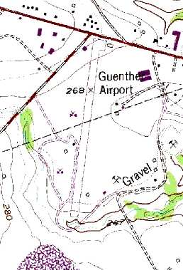
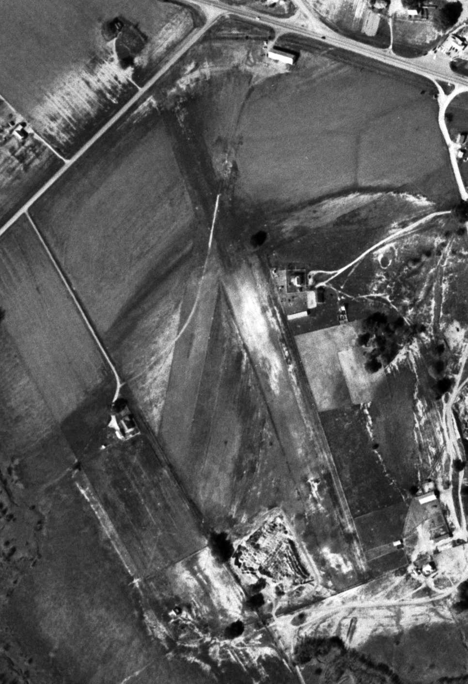
The 1981 USGS topo map depicted Guenther Airport as having a single north/south runway.
In 1992 the new & larger Fayette Regional Air Center Airport was opened 2 miles west of La Grange,
and Guenther Municipal Airport was presumably closed at the same time.
A 1/22/96 USGS aerial view looking southwest showed the paved runway of the former Guenther Municipal Airport remained completely intact.
Guenther Municipal Airport was still depicted as an abandoned airfield
on the October 2003 San Antonio Sectional Chart (courtesy of David Brooks).
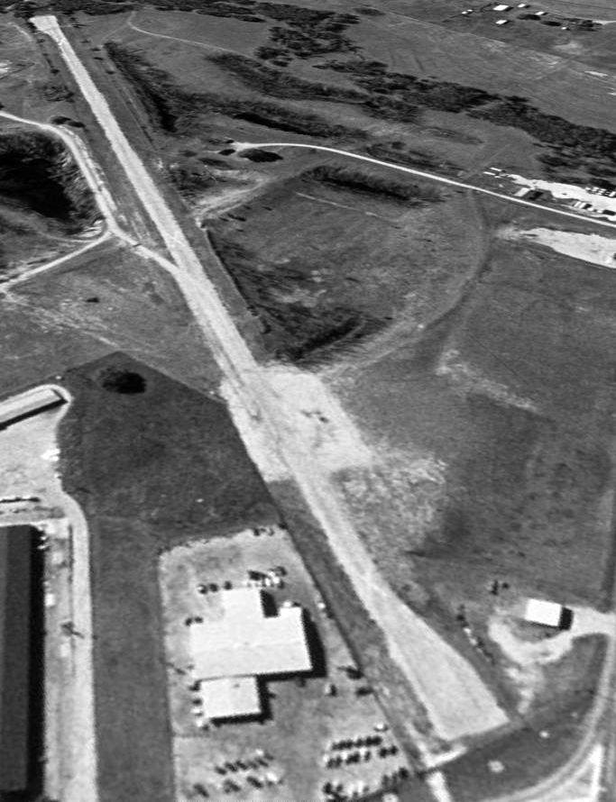
A circa 2004-2010 aerial photo looking south
showed the paved runway of the former Guenther Municipal Airport to remain completely intact,
with the northern end used for storage of trucks or trailers.
Note the oil well adjacent to the runway - probably the real reason for the airport's closure.
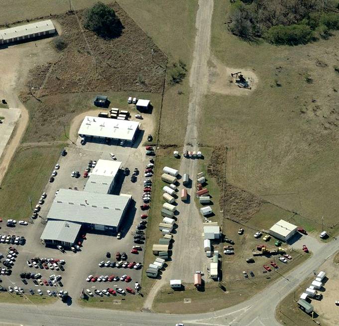
Bill Jacobs reported in 2011, “The old La Grange airfield... Its runway is still there although a used car dealer is located at the end of the runway.”
As of 2011, a street map labeled the runway as “Taylorcraft Airfield”, which may be erroneous.
The site of Guenther Municipal Airport is located south of the intersection of Route 71 & Route 609.
____________________________________________________
Cuero Field / Brayton Flying Field, Cuero, TX
29.13, -97.3 (Southeast of Austin, TX)
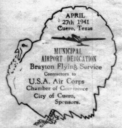
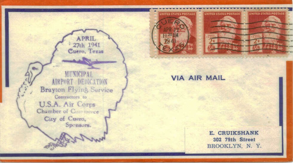
A postmark commemorated the 4/27/41 Municipal Airport Dedication of Brayton Flying Service.
The airfield at Cuero Field was evidently not a pre-WW2 civilian airport,
but rather was purpose-built for the military flight training school,
as no airfield at the site was listed in the Airport Directory Company's 1937 Airports Directory (courtesy of Bob Rambo).
According to the The Handbook of TX Online,
Cuero Field was approved by the government as a primary training facility in January 1941 & established on 2/6/41.
It was operated by Brayton Flying Service (directed by Clyde Brayton),
which conducted a contract flying school for military aviators.
According to a historical marker commemorating Brayton Flying Field,
“Clyde Brayton [was a] veteran pilot whose first licenses (1926-1931) were signed by air pioneer Orville Wright.
Cuero provided land, Brayton put in facilities & enrolled the first class in March 1941.
A staff of 550 civilians & 100 military men trained 6,611 students who flew 335,000 hours.
The field received awards for safety & meritorious service.”
A postmark commemorated the 4/27/41 Municipal Airport Dedication of Brayton Flying Service.
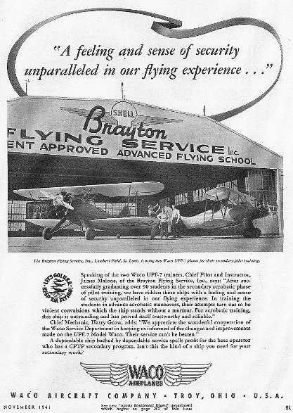
The earliest photo which has been located of Cuero Field
was an undated picture of 2 Waco UPF-7 biplane trainers in front of the Brayton Flying Service hangar
in a November 1941 advertisement for the Waco Aircraft Company.
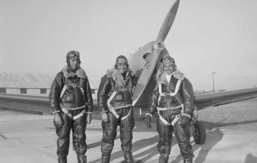
A circa 1942 photo (courtesy of Jim Rader) of a group of pilots (one of which may be Milton Tucker)
in front of a Fairchild PT-19 at Cuero Field.
All instructors & mechanics at Cuero Field were civilian,
though the army rigidly supervised the training.
The 9 week course included classes in meteorology, navigation, aircraft identification, and aircraft engines.
Training included 5 hours on the Link trainer (an early flight simulator)
and 65 hours actual flying time.
The school's capacity was 290 cadets.
Thousands of pilots who graduated from Cuero Field went on to serve in WW2.
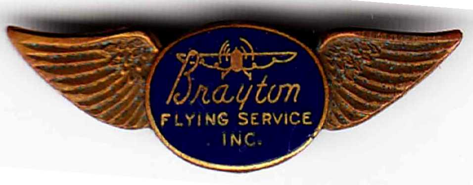
An undated set of wings from Brayton Flying Service (courtesy of Ros King).
The Brayton Flying Service School payroll brought about $145,000 a month into Cuero's economy.
The commanding officers of Cuero Field were Capt. James H. Price
and Majors Shepler W. Fitzgerald & Timothy F. O'Keefe.
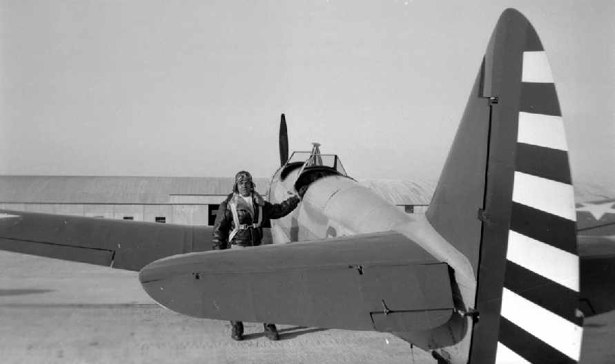
A circa 1942 photo (courtesy of Jim Rader) of Milton Tucker, of Cuero Field's Class 43-D, posing with a Fairchild PT-19.
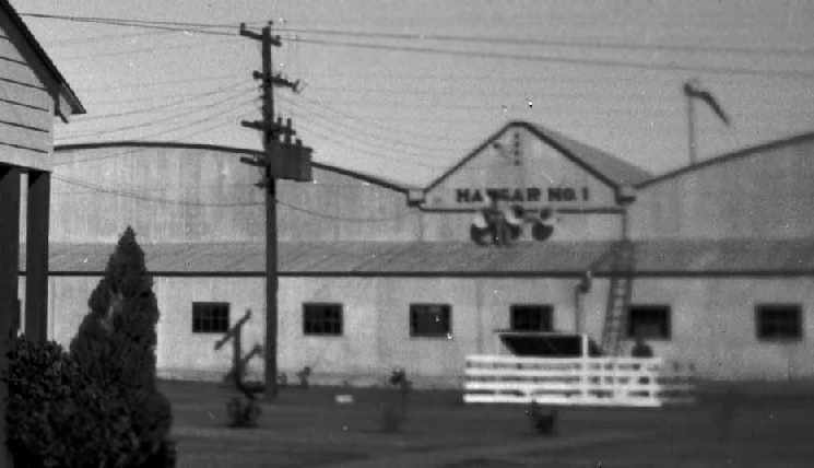
A circa 1942 photo (courtesy of Jim Rader) of Cuero Field's Hangar 1.
Tom Beamer passed along a description of Cuero Field,
from the official history of the Aeronautical Training Society
(the organization formed by the civilian operators of the USAAF Primary Training Schools):
Brayton Flying Service was originally established in St. Louis in October of 1933.
The Texas operation was organized in December 1940 & training began in March 1941.
Cuero was built during a period of continuous rain in an area known as "Brayton's Bay",
which was an old ranch & abandoned rice field with no drainage at the time of construction.
The main aerodrome covered 501 acres & had 4 hangars, 7 barracks, and 10 other buildings.
There were 4 practice fields totaling an additional 800 acres.
The school had a western motif & decor with cattle horns, spurs, Mexican decoration & furniture.
All indications are that the runways were grass.
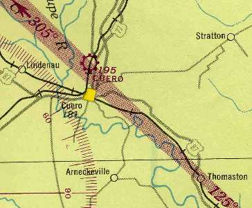
The earliest aeronautical chart depiction which has been located of Cuero Field
was on the 1943 San Antonio Sectional Chart (courtesy of Chris Kennedy).
It depicted Cuero as a commercial/municipal field.
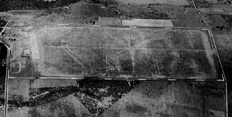
A 10/25/43 aerial view looking north from the 1945 AAF Airfield Directory (courtesy of Scott Murdock)
depicted Cuero Municipal Airport as a rectangular grass area with a paved ramp & several buildings on the west side.
The 1944 Directory of Army airfields (courtesy of Joe Benson)
described Cuero Field as having a 5,400' unpaved runway,
and indicated that Army flight operations were conducted from the field.
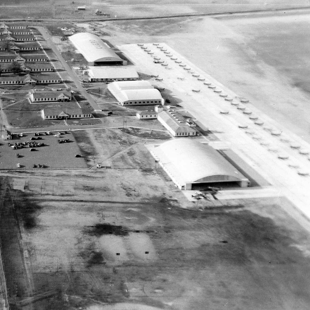
A circa 1944 aerial view (courtesy of Brian Copher) looking northeast at Cuero Field,
showing hangars, the ramp, and dozens of trainer aircraft.
A circa 1944 photo (courtesy of Brian Copher) showing AT-6 Texans & Fairchild PT-19s inside a Cuero hangar.
Flight training operations at Cuero Field were discontinued on 8/31/44.
After the school closed, the government retained one hangar to repair & service Army planes,
and Clyde Brayton moved to Houston to become president of Red Arrow Freight Lines.
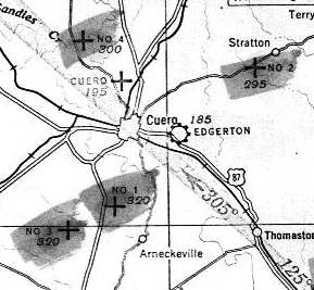
Cuero Field was still depicted as an active airfield on the 1945 San Antonio Sectional Chart (courtesy of John Voss),
along with 4 satellite airfields (simply labeled "No 1", "No 2", "No 3", and "No 4").
The 1945 AAF Airfield Directory (courtesy of Scott Murdock) described Cuero Municipal Airport
as a 501 acre rectangular property having a sod all-way landing field, measuring 5,900' north/south by 3,400' east/west.
The field was said to have 4 hangars, the largest being a 431' x 109' metal structure – remarkably large for the time.
The airport was said to be owned by the City of Cuero, and operated by private interests.
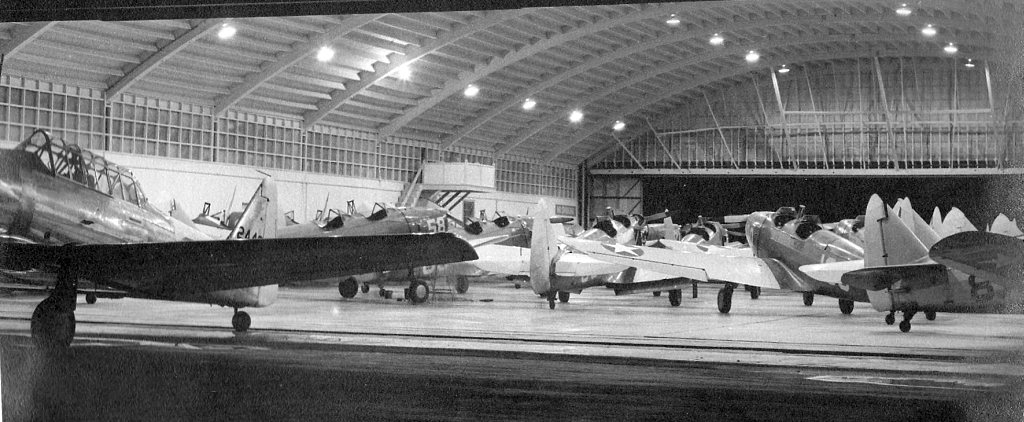
An undated aerial view looking southeast at Cuero Field,
showing a large number of trainer aircraft presumably in storage after the closure of the wartime flight training operation.
Ganey Bradfield recalled, “Regarding the old Army Training Airfield at Cuero,
in the spring of 1946, I ferried a Piper J-3 crop duster conversion to there,
for a crop dusting service based in Portland TX.
At that time the entire Cuero Field, except for the ramp area, was stacked with surplus airplanes,
mostly trainers, such as the Beech AT-7, AT-10, AT-11, the Curtis AT-9, and Cessna UC-78s.
There were 2 hangars there being used.
One hangar was being used to strip instruments & equipment from the AT-9s & AT-10s.
Those airplanes (AT-9 & AT-10) were then moved to the adjacent hangar, cut up & destroyed.
I don't know what was happening to the other Beech & Cessna airplanes there.”
Cuero Field was still depicted as an active airfield on the 1949 San Antonio Sectional Chart (courtesy of Chris Kennedy),
and described as having a 5,300' unpaved runway.
A 4/16/53 USGS aerial view depicted Cuero Municipal Airport as a rectangular grass area with a paved ramp & several buildings on the west side.
Cuero Field was evidently closed at some point between 1949-63,
as it was not listed among active airfields in the 1963 TX Airport Directory (courtesy of Steve Cruse).
By then, it had evidently been replaced by Cuero Municipal Airport,
which was built 2 miles east of the town of Cuero.
Even though Cuero Field had been closed for many years by that point,
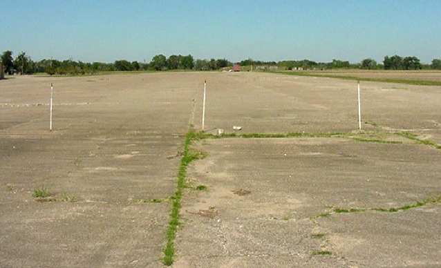
the 1981 USGS topo map still depicted a section of a single northwest/southeast runway, labeled "Landing Strip".
The 1987 USGS topo map labeled the site simply as "Airfield", and depicted the paved ramp & buildings.
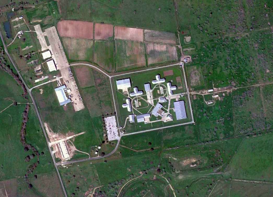
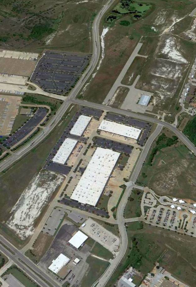
In 1994 the TDCJ Emergency Prison was completed on the center of the former Cuero Field.
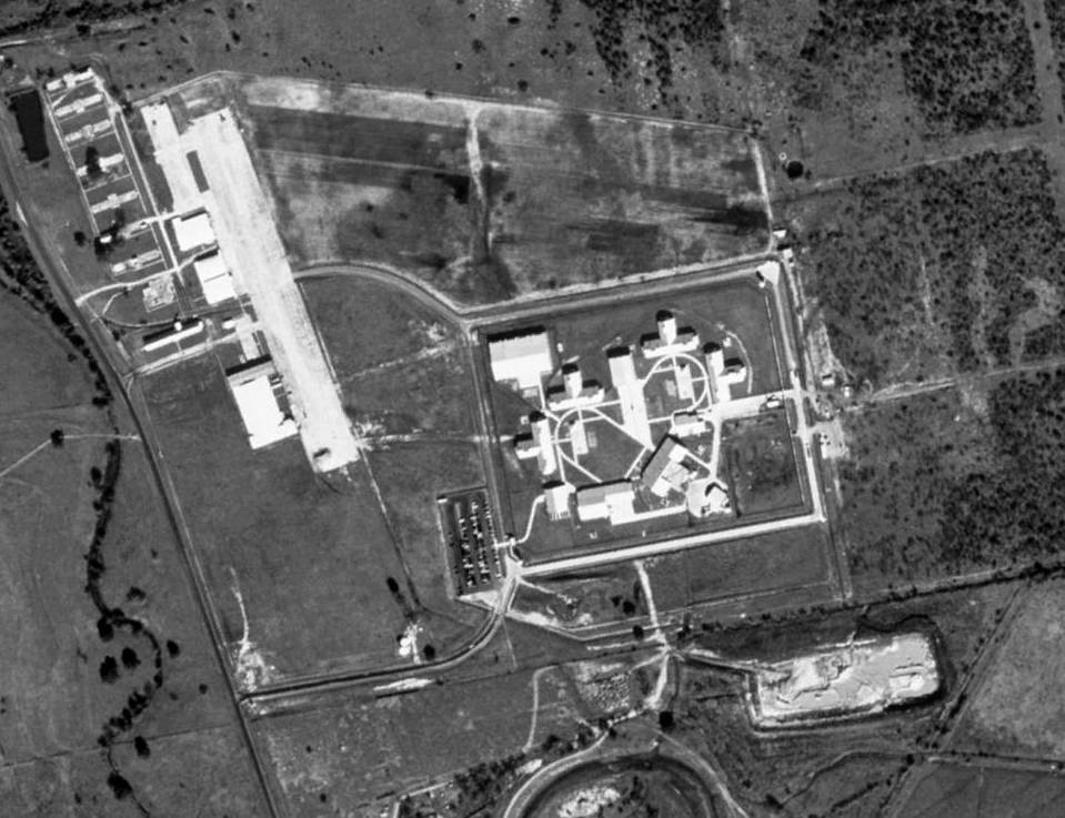
In a 1/22/95 USGS aerial photo, the paved ramp area remained intact,
along with several former hangars & other airfield buildings along the west side of the ramp.
The newly-constructed prison is seen just southeast of the ramp.
A 2003 photo by Scott Murdock of the remaining ramp at the former Cuero Field.
A 2003 photo by Scott Murdock of one of the remaining hangars at the former Cuero Field.
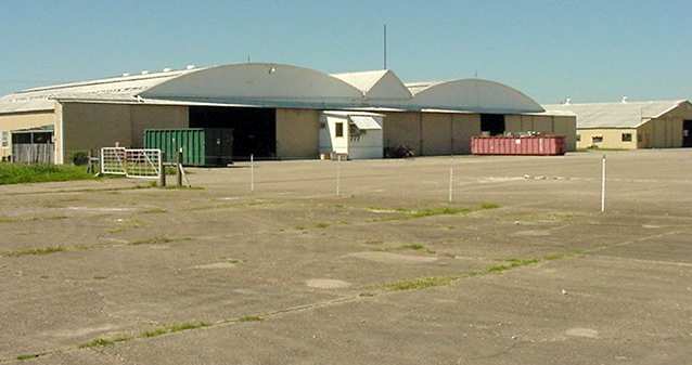
A 2003 photo by Scott Murdock of the remaining ramp at the former Cuero Field.
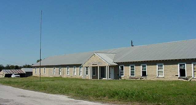
Scott Murdock visited the site of Cuero Field in 2003.
"I was able to set foot on part of the concrete ramp & observe 2 different hangars
and what I believe was the administration building, complete with flagpole.
Part of the actual flying field is now occupied by a prison."
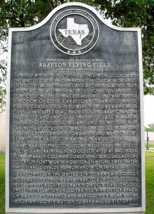
A 4/24/07 photo of a historical marker commemorating Brayton Flying Field.
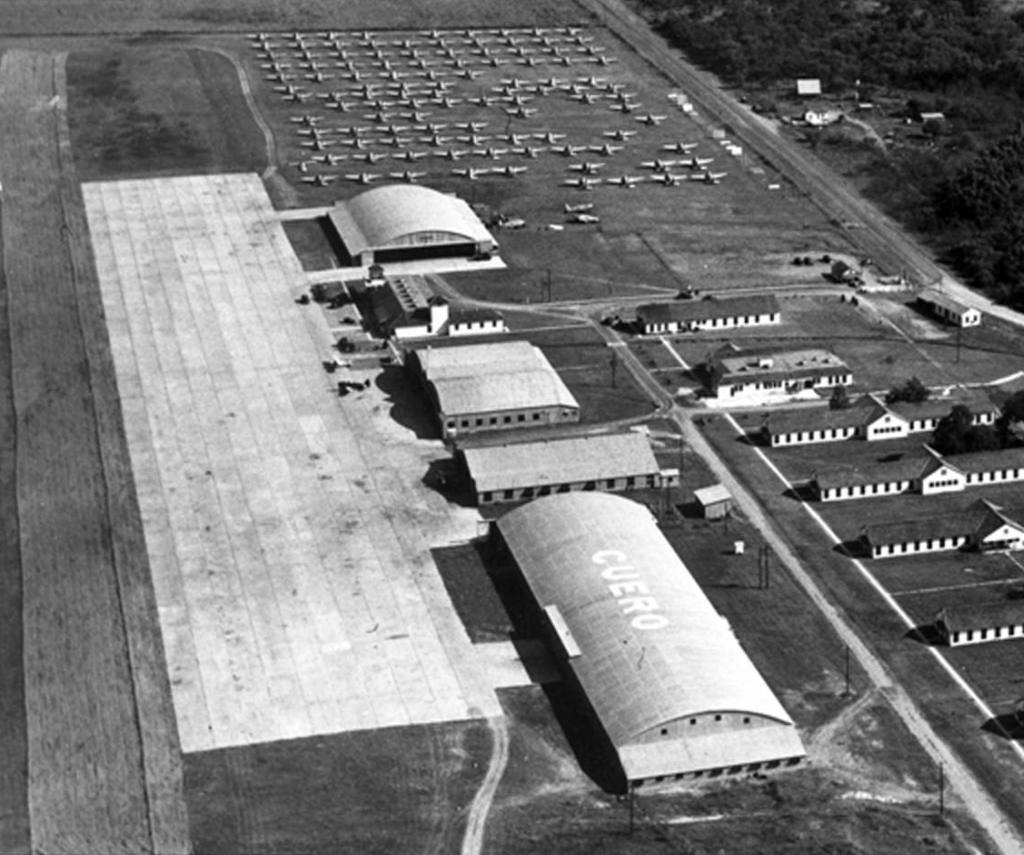
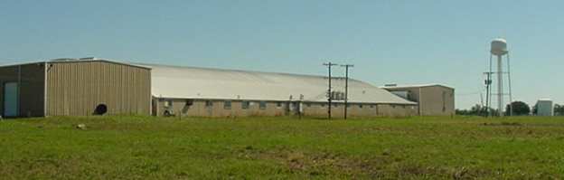
A circa 2010 aerial view looking west at the site of Cuero Field showing the ramp & 4 former hangars remaining intact.
In a 3/3/12 aerial photo of the site of Cuero Field, the ramp & several former hangars remained intact.
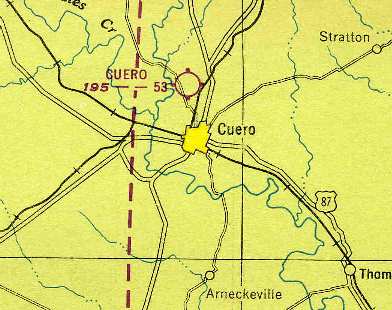
The site of Cuero Field is located southeast of the intersection of Route 766 & Blackwell Road.
____________________________________________________
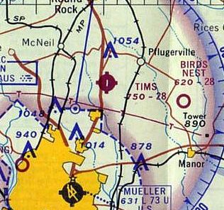
Tim's Airpark / Austin Executive Airpark (3R3), Austin, TX
30.42, -97.67 (Northeast of Austin, TX)
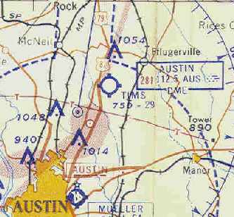
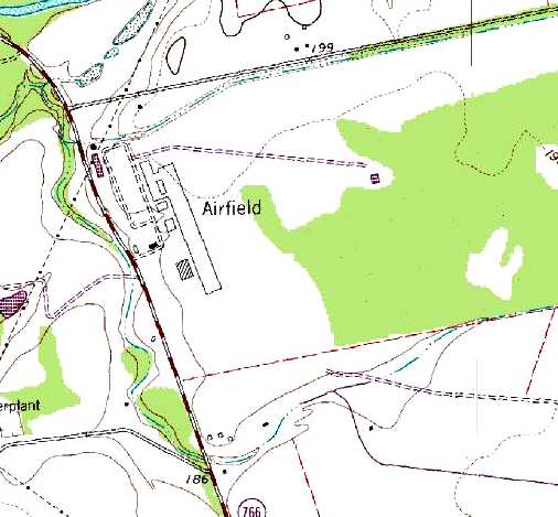
Tim's Airpark, as depicted on the April 1959 Austin Sectional Chart (courtesy of Chris Kennedy).
According to the book “Austin, Cleared For Takeoff” by William Ragsdale (courtesy of Rob Schmidt),
Theodore Timmerman purchased 250 acres of farmland in 1956.
Shortly thereafter. Jim Boutwell leased 20 acres to construct an airport.
The earliest depiction of Tims which has been located
was on the April 1959 Austin Sectional Chart (courtesy of Chris Kennedy).
It depicted the field as having a 2,900' unpaved runway.
Tim's Airpark apparently gained a paved runway within the next year,
as the 1962 AOPA Airport Directory described the field as having a single 2,800' asphalt Runway 17/35.
It listed the operator as Tim's Airpark Inc.
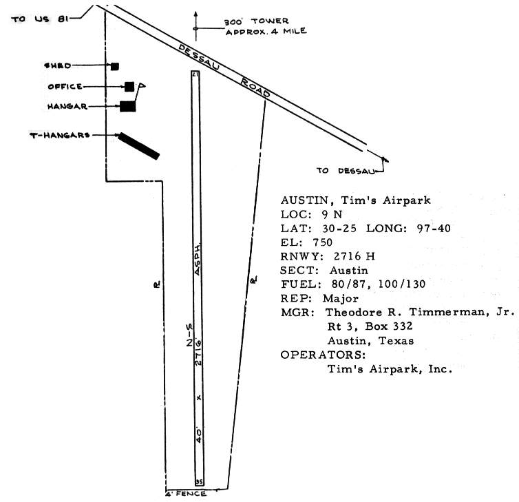
The 1963 TX Airport Directory (courtesy of Steve Cruse)
depicted Tim's Airpark as having an office & 2 hangars,
situated west of the runway along Dessau Road.
The manager was listed as Theodore Timmerman.
The orientation depicted of the runway, due north/south, may have been erroneous,
as every subsequent depiction of the runway shows it to be oriented north-northeast/south-southwest.
The earliest photo that has been located of Tim's Airpark was a 1964 aerial view.
It depicted the single runway, with several hangars & a dozen light planes on the northwest side.
The 1966 Austin Sectional Chart (courtesy of John Price) depicted Tims Airpark as having a 2,800' paved runway.
A 1967 aerial view shows that another hangar had been added at some point between 1964-67.
By the time of the 1970 TX Airport Directory (courtesy of Ray Brindle),
the runway had been lengthened to 4,000' with a full-length parallel taxiway,
a larger ramp had been built along the west side of the runway,
and several new hangars had been built along the southwest side.
The earliest photo which is available of Tim's Airpark was a 1973 aerial view.
Yet another hangar had been added at some point between 1967-73.
A large number of aircraft were visible on the field, including a DC-3.
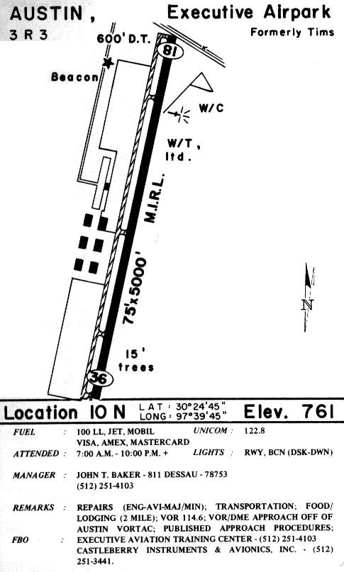
By the time of the 1985 TX Airport Directory (courtesy of Steve Cruse),
the airport had been renamed Austin Executive Airpark.
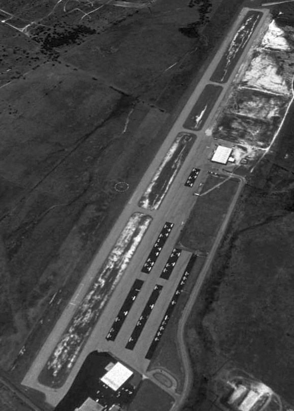
A 1985 aerial view showed 3 more hangars had been added at some point between 1973-85.
A large number of aircraft were visible on the field, including a DC-3.
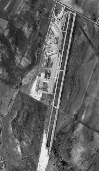
The last photo which has been located showing Austin Executive Airport still in operation was a 2/1/95 USGS aerial view looking southeast.
The airport was evidently well-used right up to the end, as a total of over 50 light aircraft were visible on the field.
Austin Executive Airport closed unexpectedly in 2000.
This came as a double blow to the general aviation community in Austin,
which in the preceding year had lost its only other airport supporting general aviation (Austin Mueller).
The last photo which has been located showing Austin Executive Airport still mostly intact was a circa 2000 aerial view, apparently after the field had been closed.
The runway was still intact, but most of the hangars had been removed,
and all of the large numbers of planes previously seen were gone.
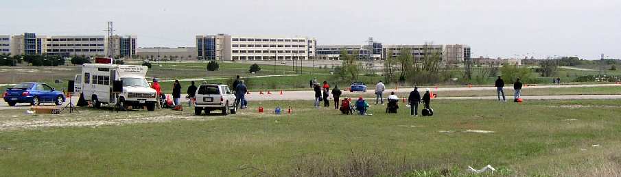
A 2003 photo by Kent Dyer of the former runway at Austin Executive Airport, now reused for car racing by an firm called Tech.Ridge.
Nearby resident Kent Dyer reported in 2003 that the large buildings northeast of the airport are Dell Computer Corporation factories,
offices for NCS Pearson, and various tech vendors to Dell.
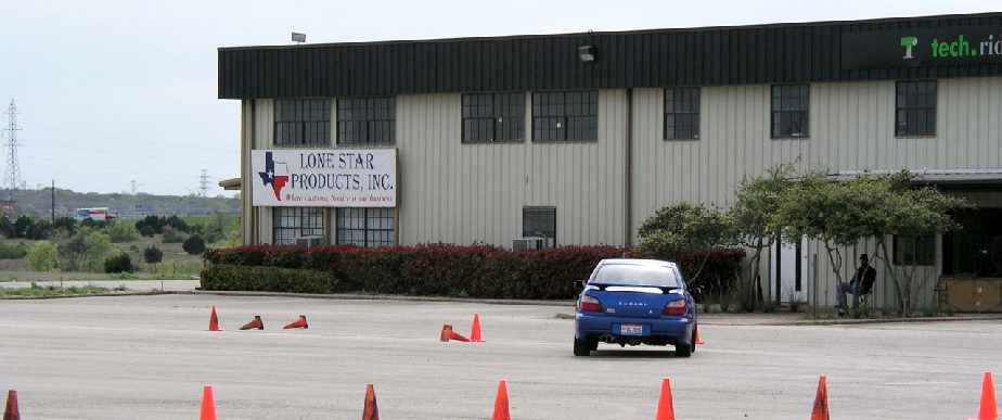
A 2003 photo by Kent Dyer of the former hangar at Austin Executive Airport,
now reused for non-aviation purposes by Lone Star Products.
Kent Dyer reported in 2005, “Car racing is no more at the old Austin Executive Airpark location.
'No Trespassing' signs are up all over the place,
and Wackenhut security patrols the location regularly (I believe they provide security for the Dell factories across the street).
I understand the racing kabosh is due to insurance liability issues -
and also it seems that the development of the area is really taking off.
Recently Dell Computer Corporation has begun parking empty trailers on the old tarmac,
and the old road that led into the airport from Howard Lane has been turned under by bulldozers,
and a City of Austin Metro Transit center is being built just west of where the airport used to be.”
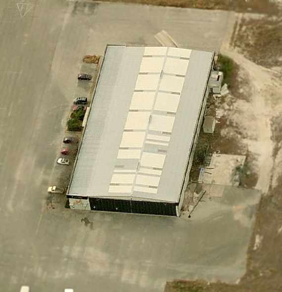
A circa 2005-2006 aerial view looking south at the former hangar
which remains standing on the west side of the former Austin Executive Airport.
Note the heliport symbol still perceptible at the top-left.
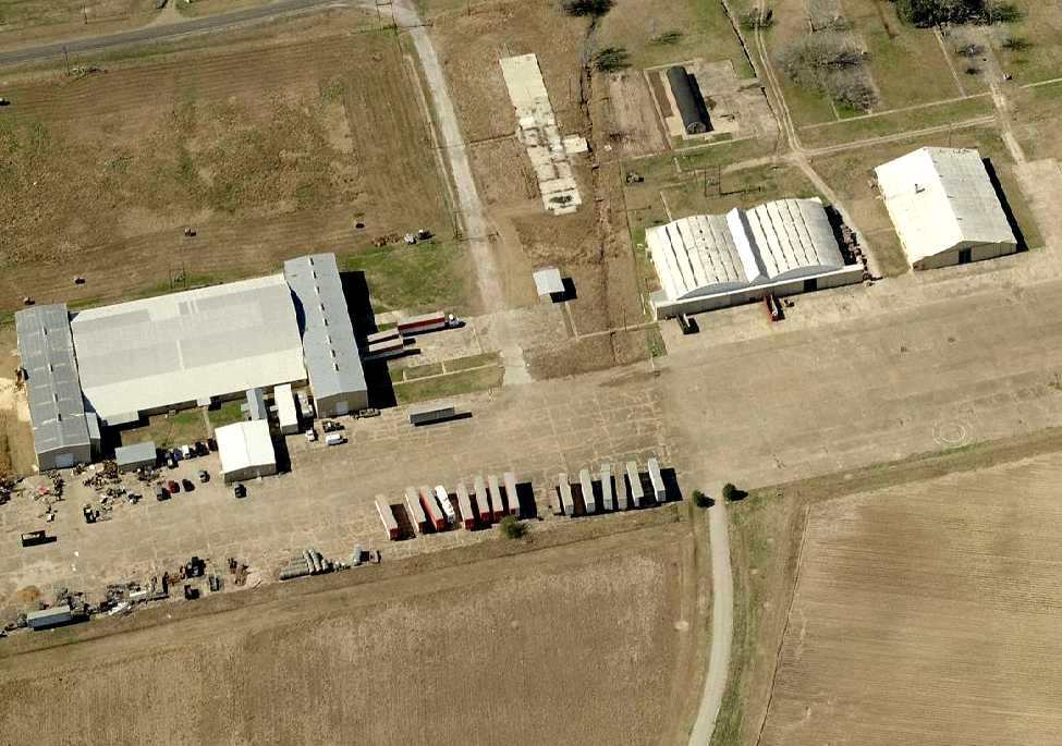
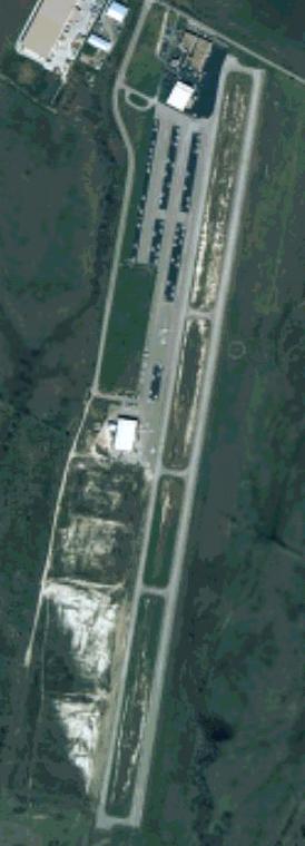
An 8/1/12 aerial view looking southeast at the site of Austin Executive Airport showed quite a difference compared to earlier photos.
Large industrial buildings covered the northern end of the former airfield,
but the original airport buildings remained intact at the northern end,
as well as one building on the west side of the middle of the runway.
A significant portion of the middle of the runway & taxiway pavement remained intact as well.
____________________________________________________
Since this site was first put on the web in 1999, its popularity has grown tremendously.
That has caused it to often exceed bandwidth limitations
set by the company which I pay to host it on the web.
If the total quantity of material on this site is to continue to grow,
it will require ever-increasing funding to pay its expenses.
Therefore, I request financial contributions from site visitors,
to help defray the increasing costs of the site
and ensure that it continues to be available & to grow.
What would you pay for a good aviation magazine, or a good aviation book?
Please consider a donation of an equivalent amount, at the least.
This site is not supported by commercial advertising –
it is purely supported by donations.
If you enjoy the site, and would like to make a financial contribution,
you
may use a credit card via
![]() ,
using one of 2 methods:
,
using one of 2 methods:
To make a one-time donation of an amount of your choice:
Or you can sign up for a $10 monthly subscription to help support the site on an ongoing basis:
Or if you prefer to contact me directly concerning a contribution (for a mailing address to send a check),
please contact me at: paulandterryfreeman@gmail.com
If you enjoy this web site, please support it with a financial contribution.
please contact me at: paulandterryfreeman@gmail.com
If you enjoy this web site, please support it with a financial contribution.
____________________________________________________
This site covers airfields in all 50 states.