Abandoned & Little-Known Airfields:
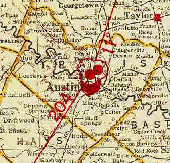
Texas - Western Austin area
© 2002, © 2015 by Paul Freeman. Revised 11/11/15.
This site covers airfields in all 50 states: Click here for the site's main menu.
____________________________________________________
Please consider a financial contribution to support the continued growth & operation of this site.
Austin Mueller Airport (revised 11/11/15) - Haile Airport (revised 11/4/15) - Kittie Hill Airport (revised 1/2/14) - Penn Field (revised 8/7/14)
San Marcos Intermediate Field #30 / #31 / #31B / Thompson Field (revised 11/2/11)
(Original) San Marcos Municipal Airport / Robert Lowman Airport (revised 6/20/12) - University Airport (revised 11/4/15)
____________________________________________________
Kittie Hill Airport (77T), Leander, TX
30.6, -97.823 (Northwest of Austin, TX)
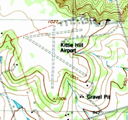
Kittie Hill Airport, as depicted on the 1987 USGS topo map.
Kittie Hill Airport was not yet depicted on the 1966 Austin Sectional Chart (courtesy of John Price).
According to its FAA Airport/Facility Directory data, this small general aviation airport was activated in March 1976.
Cynthia Grant reported that there is “an article with an account of how Kittie Hill got started in the December 1983 issue of EAA's Sport Aviation.”
The earliest depiction which has been located of Kittie Hill Airport was on the 1987 USGS topo map.
It depicted Kittie Hill as having 3 unpaved runways, with a large number of small hangars on the northeast side.

The earliest photo which has been located of Kittie Hill Airport was a 1/6/96 USGS aerial view looking west.
It depicted the field as having 3 grass runways, with multiple small hangars hangars on the northeast side.

A 10/3/3 photo by Eric Dierks of a 1989 Su-26, a Russian competition aerobatic plane, with its smoke system activated at Kittie Hill Airport.

A 6/18/05 aerial view of a good number of light planes at Kittie Hill Airport.
As of 2013, the FAA Airport/Facility Directory data described Kittie Hill as having 3 turf runways, the longest being the 3,450' Runway 7/25.
All 3 were described as being “in poor condition”.
The owner & manager were listed as Charles Densford.
Kittie Hill was said to have 71 based aircraft, of which 13 were homebuilt,
and to conduct an average of 62 takeoffs or landings per day.
According to Cynthia Grant, “The number of aircraft - that number has always puzzled me;
I think there were probably 71 hangars & maybe 60 or so flyable airplanes up until a couple of years ago.
Some hangars were used to store non-flyable airplanes, airplane parts, and a couple contained non-aviation 'stuff'.
The 62 daily operations number was probably true in the 1990s when there was a flight school on the field, but there hasn't been that much activity in several years.
There is a hangar shortage in the Austin area so the hangars were usually full.
The economic downturn in 2008 probably gave us an extra 5 years.”
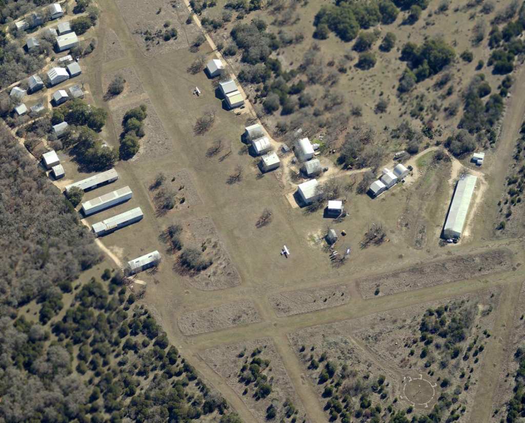
A circa 2008-2013 aerial view looking east at the large number of small hangars on the northeast side of Kittie Hill Airport.
Also visible are 2 single-engine aircraft, portions of 3 grass runways, and the segmented circle marking.

A 10/31/13 aerial view looking west depicted the 3 grass runways & multiple hangars at Kittie Hill Airport,
but only a single aircraft was visible parked outside.

The 2013 Sectional Chart depicted Kittie Hill Airport as a public-use airport having a 3,400' unpaved runway.
Cynthia Grant reported in on 1/1/14, “I kept my plane there for 20+ years.
Kittie Hill has been sold to developers - it is basically closed as of yesterday.”
Kittie Hill Airport is located northeast of the intersection of Ronald Reagan Boulevard & Hero Way.
____________________________________________________
30.23, -97.76 (South of Downtown Austin, TX)
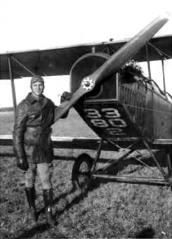
A circa 1917-18 photo of a Jenny biplane at Penn Field.
As America entered World War I & saw a need for aviators,
many US cities stepped up & provided facilities to encourage training in the new art of flying.
Austin was no exception, with local boosters jockying to get Army Air Corps training opportunities for the Central Texas area.
In 1917 the Austin Chamber of Commerce secured options on 1,700 acres south of Austin,
some of which had been part of the Blocker Ranch.
General George Squire, chief signal officer of the United States Army Signal Corps,
deemed 150 acres suitable for a landing field; he approved the site in September 1917.
Penn Field was named after Austin aviator Eugene Doak Penn, who died while training in Italy on 5/20/18.
It was established for use of the School of Military Aeronautics conducted by the University of TX for the federal government.
It was not until 1918 before planes started landing at Penn Field, and in doing so they encountered several obstacles.
Lt. John McCurdy, commander of advanced cross-country & formation flying at Kelly Field,
made a flight into the field & approved it except for the rocks & cornstalks.
The Chamber of Commerce appointed a cleanup committee,
and on 4 Sundays in September volunteer labor, including Boy Scouts & boys from the Deaf & Dumb Institute
picked up & hauled away 317 truckloads of rocks from the surface.
Lt. McCurdy subsequently began bringing in flights of 12-20 planes several times a week.
In March 1918 the University of TX was authorized to establish a radio school at the site.
The university took up the option on the land & purchased 318 acres for $40,000.
A railway track was laid to the site, and by November 1918 five brick buildings totaling 168,000 square feet were constructed.
The Chamber of Commerce has insisted on brick buildings since they intended for them to be used as factories after the war.
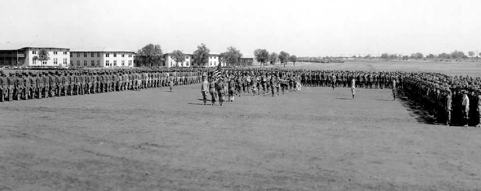
A circa 1917-18 photo of soldiers training at Penn Field.
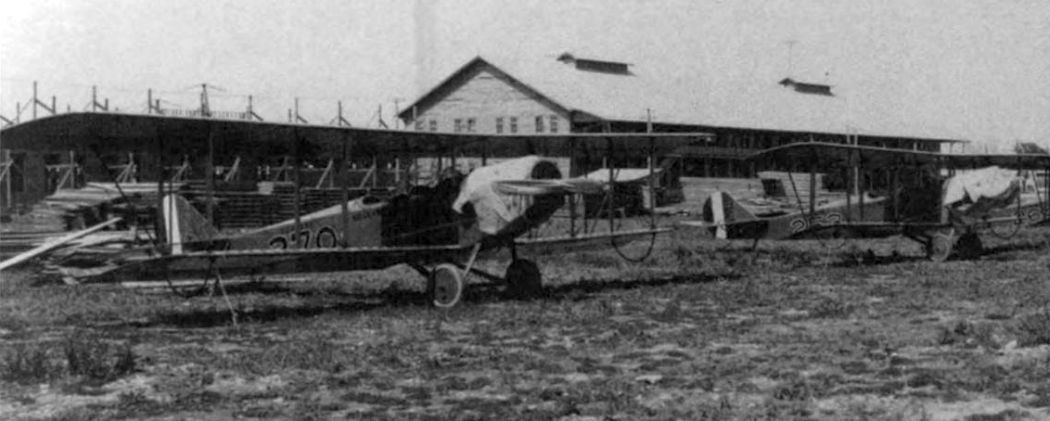
A circa 1917-18 photo of JN-4 trainers at Penn Field. (courtesy of Rob Schmidt).
A circa 1917-18 photo of members of the Austin community meeting officers at Penn Field. (courtesy of Rob Schmidt).
After the war ended in 1918 the site was auctioned off to the highest bidder for $107,000.
The Woodward Truck Body Company installed machinery there & manufactured wooden truck bodies
until the plant was destroyed by a tornado on 5/4/22.
The buildings were reconstructed, and the Woodward Furniture Factory went into operation in them
and manufactured furniture during most of the Great Depression.
No airfield was depicted at the site on the 1943 Austin Sectional Chart, nor on the 1955 USGS topo map.
Over the years the state of the buildings began to deteriorate.
In the fall of 2000 the buildings were renovated into modern office space.
Thankfully, the developers chose not to tear down the old brick buildings, but instead they built within them.
The buildings are completely modern inside with an aged exterior that hints at its history.
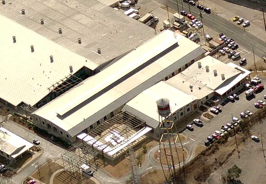
A circa 2007 aerial view looking south at the buildings which remain at the site of Penn Field.
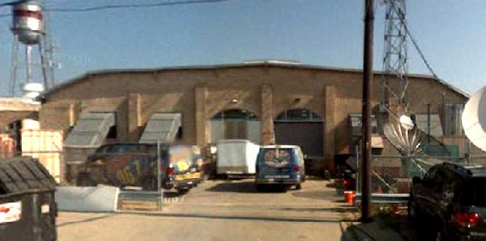
A 2008 photo looking north at the Penn Field building.

A 2010 photo of a fountain at Penn Field which appears to have been constructed of 2 airplane wings.
The site of Penn Field is located east of the intersection of South Congress Avenue & Alpine Road West.
____________________________________________________
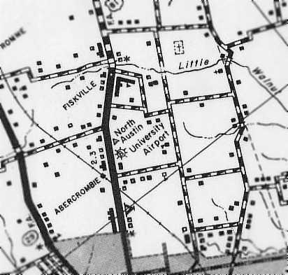
University Airport, Austin, TX
30.345, -97.71 (Northwest of Austin Mueller Airport, Austin, TX)

University Airport was owned & operated by the University of Texas in Austin.
According to the book “Austin, Cleared For Takeoff” by William Ragsdale (courtesy of Rob Schmidt),
Webb Ruff began fixed base operations at University Airport in 1925.
The earliest photo which has been located of University Airport
was a November 1927 photo of 2 Waco GXE biplanes & a hangar (courtesy of Jeff Morrison).


An advertisement for the University Aerial Service Company appeared in the 8/23/28 issue of Aviation Magazine (courtesy of Chris Kennedy).
The 1929 Rand McNally Air Trails Map (courtesy of Chris Kennedy)
described University as a commercial airport consisting of a 2,500' square landing area.
The operator was listed as S.W. Ruff.
The Airport Directory Company's 1933 Airport Directory (courtesy of Chris Kennedy)
described University as a commercial airport consisting of a 2,500' square sod landing area.
The hangar was said to have "University" & "Austin" painted on the roof.

The earliest aeronautical chart depiction which has been located of University Airport was on the 1934 Austin Sectional Chart.
The location of University Airport, as depicted on a 1936 TX State Highway Department map (courtesy of Chris Kennedy).

An aerial view looking north at University Airport,
from The Airport Directory Company's 1938 Airport Directory (courtesy of Chris Kennedy).
The directory described University as a commercial airport having 2 sod runways in an L-shape:
a 3,420' north-northeast/south-southwest & 3,130' west-northwest/east-southeast.
The hangar was said to have "University" & "Austin" painted on the roof.
Emma Carter Browning, a pioneer in Austin aviation, and her husband, barnstormer Robert Browning Jr.
started a Fixed Base Operation, Browning Aerial Services, at University Airport in 1939,
and trained many thousands of aviators in the years to come.

University Airport, as depicted on the 1940 Austin Sectional Chart (courtesy of David Brooks).

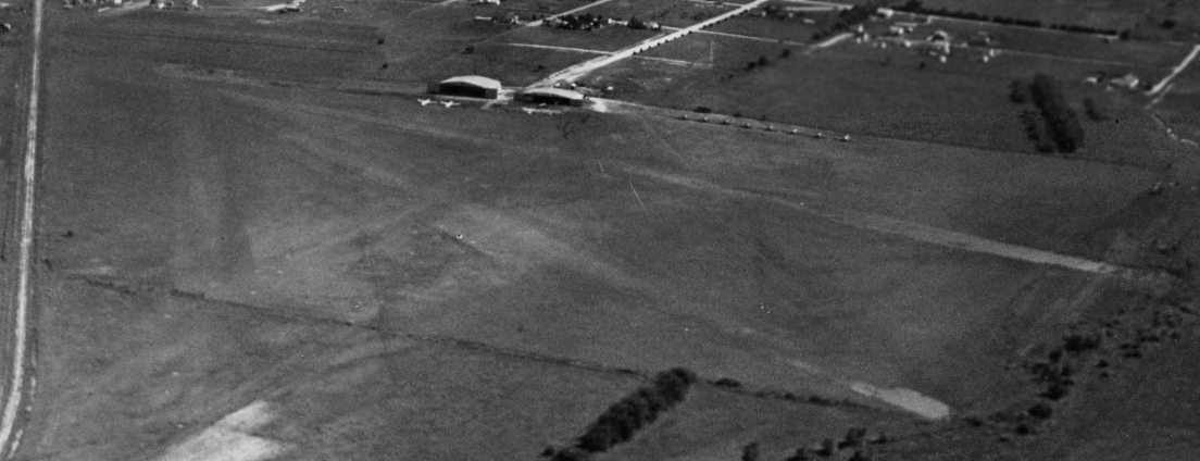
A 1940 aerial view (courtesy of Rob Schmidt) depicted University Airport as having 3 unpaved runways & a building along the west side.

The Airport Directory Company's 1941 Airport Directory (courtesy of Chris Kennedy)
described University as a commercial airport having 2 sod runways in an L-shape:
a 3,420' north-northeast/south-southwest & 3,130' west-northwest/east-southeast.
The hangar was said to have "University" & "Austin" painted on the roof.

A circa 1942 photo (courtesy of the UT library, via David Brooks)
of unformed cadets undergoing aviation training at University Airport.

A 1943 aerial view looking north at University Airport,
from the 1945 AAF Airport Directory (courtesy of Chris Kennedy).
It depicted the field as having 3 unpaved runways.
The April 1944 US Army/Navy Directory of Airfields (courtesy of Ken Mercer)
described University Airport as having a 2,600' unpaved runway,
and also indicated that Navy flight operations were conducted from the field.
The Haire Publishing Company's 1945 Airport Directory (courtesy of Chris Kennedy)
described University as having 2 asphalt runways in an L-shape:
3,000' north/south & 2,090' northwest/southeast
[this was the only reference among several directories of University having a paved runway,
so this may have been in error].
The field was said to be a "class 2" airport, privately owned & operated.
The field was said to have a hangar, and the manager was listed as Robert Browning.
Browning Aerial Services relocated from University to Austin's Robert Mueller Airport in 1946.

The February 1949 Austin Sectional Chart (courtesy of Chris Kennedy)
depicted University as having a 3,400' unpaved runway.

University Airport was evidently closed at some point in 1949,
as a 9/26/49 aerial view looking west (courtesy of Jeff Morrison) showed the hangars being reused for non-aviation commercial puposes.
University Airport was no longer depicted on the 1950 Austin Sectional Chart (courtesy of David Brooks).
According to the book “Austin, Cleared For Takeoff” by William Ragsdale (courtesy of Rob Schmidt),
on 7/21/52 Webb & Myrtle Ruff deeded the 23 acres of University Airport to the Northway Crest Development Company.
University Airport was no longer depicted at all on the 1954 USGS topo map.

The last photo which has been located showing any trace of University Airport was a circa 1960 aerial view (courtesy of John Lane).
According to John, “It shows the University Airport site after closure but most of the buildings are still standing.
The location is Airport Boulevard at Lamar Boulevard (Dallas Highway back then)
across from the Jefferson Chemical Company near the International-Great Northern Railway (Southern Pacific) tracks.”
A 1964 aerial photo showed that the site of the former University Airport had been redeveloped,
with no recognizable trace remaining of the former airport.
David Brooks reported in 2004, "Nothing remains of the area where University existed.
I drove along the road & did not recognize anything like a structure that would be associated with an airfield."
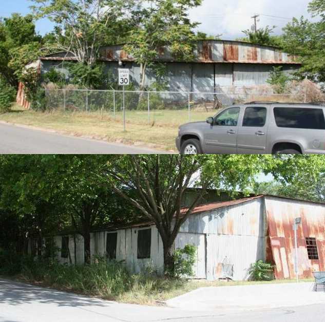
Galen Blake reported in 2010 about a hangar-shaped building used by Alamo Glass, near the site of University Airport.
Galen reported, “This building has been extensively remodeled on the south half (right side) of the building
but remains in a more original state on the north half (left side) of the building.
In the un-remodeled side of the building (north), there are roof trusses and some posts on the side of the building but none in the interior of the building ... similar to a hangar.
I can offer no definitive proof on the original nature of these buildings.
The folks occupying these buildings are working for their respective companies & are not much interested in talking about subjects other than their own work.
If anyone wants to investigate this possible connection to the old airport further, they should contact the building owners directly.”
However, John Thywissen reported in 2011 that county tax records show this building to have been built in 1945 or 1947,
and that it is located just south of the University Airport site.

A 2015 aerial photo did not show any recognizable large-scale trace remaining of the former University Airport.
The site of University Airport is located east of the intersection of North Lemar Boulevard & St. Johns Avenue.
____________________________________________________
30.32, -97.72 (Northwest of Austin Mueller Airport, Austin, TX)
Haile Airport, as depicted on the 1940 Austin Sectional Chart (courtesy of David Brooks).
According to Austin Explorer, Haile Airport was established in 1939 by Doc Haile,
in what is now the neighborhood of Skyview.
The small facility was on 50 acres & primarily used for general aviation.
The earliest depiction which has been located of Haile Airport
was on the 1940 Austin Sectional Chart (courtesy of David Brooks).
The Airport Directory Company's 1941 Airport Directory (courtesy of Chris Kennedy)
described Haile as a commercial airport having 3 sod runways, with the longest being the 2,800' north/south strip.
The field was said to have a hangar.
During WW2 some GI flight training reportedly took place at Haile Airport.

The only dated photo which has been located showing Haile Airport in operation
was a 10/24/43 aerial view looking north from the 1945 AAF Airfield Directory (courtesy of Scott Murdock).
It depicted Haile Airport as an open grass area with a few small buildings on the southwest side.
The April 1944 US Army/Navy Directory of Airfields (courtesy of Ken Mercer)
described Haile Airport as having a 2,300' unpaved runway.
The 1945 AAF Airfield Directory (courtesy of Scott Murdock) described Haile Airport
as a 98 acre triangular property within which was a 2,300' x 1,900' sod all-way landing area.
The field was said to have 2 metal hangars, with the largest measuring 100' x 70'.
Haile Airport was described as being owned & operated by private interests.
The Haire Publishing Company's 1945 Airport Directory (courtesy of Chris Kennedy)
described Haile as a "class 1" airport, privately owned & operated.
The field was said to have a total of 4 gravel runways,
with the longest being the 2,800' north/south strip.
The field was said to have 2 hangars.
The operator was listed as the Haile Flying Service, and the manager was F. R. Haile.
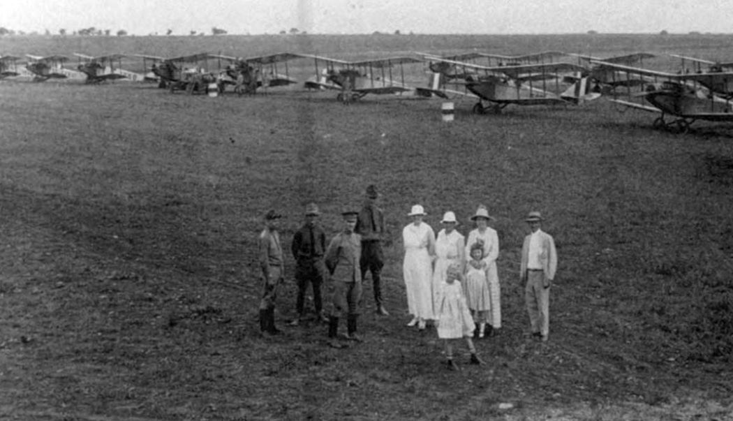
An undated aerial view looking south (courtesy of Jeff Morrison) depicted Haile Airport as having 2 unpaved runways,
with 2 hangars & a dozen light aircraft on the south side.

The last depiction which has been located of Haile Airport was on the 1950 Austin Sectional Chart (courtesy of David Brooks).
It depicted Haile as having a 2,300' unpaved runway.
According to the book “Austin, Cleared For Takeoff” by William Ragsdale (courtesy of Rob Schmidt),
Doc Haile had sold his remaining aircraft & terminated operations by the end of 1950.
Haile Airport was no longer depicted at all on the August 1952 Austin Sectional Chart (according to Chris Kennedy),
nor on the 1954 USGS topo map.
By the time of a 1964 aerial photo,
the site of Haile Airport had been densely redeveloped, with only one hangar remaining.

As seen in the above 1995 USGS aerial photo,
the site of the former Haile Airport has been densely redeveloped,
with the only remaining trace being the former hangar (the white building just above the center of the photo).

A 2004 photo of the front of the former Haile Airport hangar.
"Haile Flying Service" is still faintly legible over the hanger door.
The only remaining sign of the airport is one of its metal hangars.
The decaying structure now serves as storage space for Howard Nursery on Koenig Lane.
"Haile Flying Service" can faintly be read over the hangar door.
The hangar was constructed of a metal frame with a corrugated metal surface
that is attached to the frame with metal wire punched through the paneling.
It's not really built to be permanent, but it still does its job today.
Inside there is a large central area for plane storage.
Around it, spaces that must have been used for offices or storage spaces occupy walled off areas where the ceiling was lower.

A 2004 photo of the back of the former Haile Airport hangar.

A 2004 photo of the interior of the former Haile Airport hangar.

A 2004 photo of lettering which remains in the interior of the former hangar,
instructing that all "Must strictly adhere to Civil Air Regulations."

A circa 2005-2006 aerial view looking south at the remaining former Haile Airport hangar.
Two 2008 photos by Dick Merrill of the front & back of the former Haile Airport hangar.
Dick reported, “It doesn't look like the property has been sold yet.”
Tyler Kee reported that the Haile hangar was demolished in November 2013.

A December 2013 photo by Tyler Kee of the site of the Haile Airport hangar, now removed.
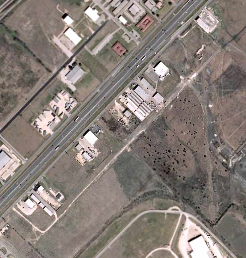
The site of Haile Airport is located at 111 East Koenig Lane,
only 1.5 miles northwest of the site of Austin Mueller Airport.
Thanks to Konrad Kelly for pointing out this airfield.
____________________________________________________
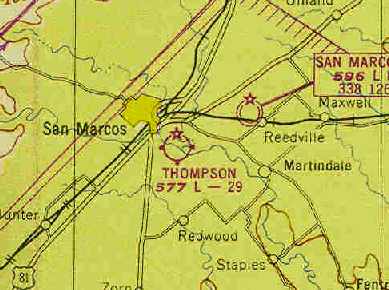
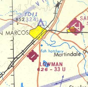
San Marcos Intermediate Field #30 / Intermediate Field 31 / Intermediate Field 31B /
Thompson Field, San Marcos, TX
29.864, -97.914 (Southwest of Austin, TX)

San Marcos Intermediate Field #30, as depicted on the 1934 San Antonio Sectional Chart.
The original airport for the town of San Marcos was located on the southeast side of the town.
It apparently was originally established by the Civil Aeronautics Administration as an Intermediate Field,
one of the network of such fields which were established along commercial airways between major cities.
The original San Marcos Airport was evidently established at some point between 1929-31,
as it was not yet listed at all in the 1929 Commerce Department Airway Bulletin (according to David Brooks).
The earliest reference to the San Marcos Airport which has been located
was in the 1931 Commerce Department Airway Bulletin (according to David Brooks).
It was listed as the CAA Intermediate Field #30.
The earliest depiction of the airfield which has been located
was on the 1934 San Antonio Sectional Chart, which depicted it as Site #30.
In 1934 the field was evidently redesignated as Site #31 (according to David Brooks).
In 1940 the field was redesignated yet again as Site #31B (according to David Brooks).

The only photo which has been located showing San Marcos Intermediate Field in operation
was a 10/24/43 aerial view looking north from the 1945 AAF Airfield Directory (courtesy of Scott Murdock).
It depicted “San Marcos Intermediate Field (Thompson Airport)” as an open grass area.
James Patton recalled, "I began taking flying lessons at the old San Marcos Airport in 1944.
I'm sure it was one of the emergency landing fields sited by the CAA,
because it had the standard rotating airways beacon.
Ragsdale Flying Service of Austin operated the field,
which also trained students at Southwest Texas State Teachers College
under the War Training Service (WTS), a sister government entity to CPTP & others.
In 1944 my first instructor still wore his khakis with WTS wings,
so WTS must have been disbanded a short time before.
Several privately-owned airplanes were residents,
among which were a Culver Cadet & a Buhl Pup.
For training, Ragsdale operated one or two J3 Cubs, a Piper J5 Cruiser, and a Meyers OTW biplane."
The San Marcos Airport was depicted as a municipal/commercial field
on the 1945 San Antonio Sectional Chart (courtesy of John Voss).
The 1945 AAF Airfield Directory (courtesy of Scott Murdock) described “San Marcos Intermediate Field (Thompson Airport)”
as a 100 acre T-shaped property within which were 2 sod runways, measuring 2,900' northeast/southwest & 2,610' WNW/ESE.
The field was said to have a single wood & metal 100' x 60' hangar.
San Marcos Intermediate Field was described as being owned & operated by private interests,
but “used as CAA Intermediate Field Site #31B”.
The 1946 Haire Publishing Company Airport Directory (according to David Brooks) listed the field as CAA Site 31B.
At some point between 1946-48 the airport was apparently renamed as "Thompson Field",
as that is how it was listed in the 1948 Haire Publishing Company Airport Directory (according to David Brooks).
The 1948 San Antonio Sectional Chart (according to David Brooks) also depicted the field as “Thompson”.
The January 1949 San Antonio Sectional Chart (courtesy of Chris Kennedy)
depicted Thompson Field as having a 2,900' unpaved runway.
The 1950 San Antonio Sectional Chart (according to David Brooks)
described Thompson as having 2 crossing runways (with the longest being a 2,900' turf strip),
and indicated the field sold gas, and carried out minor & major repairs.

The last depiction which has been located of Thompson Field was on the 1953 USGS topo map.
Thompson Field was closed at some point between 1953-55,
it was no longer depicted at all on the 1955 San Antonio Sectional Chart (according to David Brooks).
It was eventually replaced by a new San Marcos Municipal Airport, southwest of the town,
and the original airfield was apparently abandoned.
A 4/22/58 aerial view showed an open field, with no recognizable trace of a former airfield.
James Patton reported in 2004, "Reacting to a fit of nostalgia, I drove to that location last year.
The hangar & beacon are both gone & the area is under cultivation."

A 1/31/09 aerial photo did not depict any trace remaining of the former San Marcos Intermediate Field.
The airfield site is located southeast of the intersection of River Road & Old Martindale Road.
Access is from Thompson road in the upper right corner of the picture.
Thanks to David Brooks for pointing out this airfield.
____________________________________________________
(Original) San Marcos Municipal Airport / Robert Lowman Airport (5R6), San Marcos, TX
29.85, -97.96 (Southwest of Austin, TX)

The original San Marcos Municipal Airport,
as depicted on the March 1960 San Antonio Sectional Chart (courtesy of Chris Kennedy).
The 2nd airport for the town of San Marcos was located 4 miles southwest of the town,
along the southeast side of Route 81 (what would eventually become Interstate 35).
The San Marcos Municipal Airport was apparently built at some point between 1955-57,
as it was not depicted on the 1955 San Antonio Sectional Chart (according to David Brooks).
The earliest reference to the San Marcos Municipal Airport which has been located
was in the 1957 Aviation Week & Business Flyers Airport Directory (according to David Brooks).
The earliest depiction of the San Marcos Municipal Airport which has been located
was on the 1958 San Antonio Sectional Chart (according to David Brooks).
The March 1960 San Antonio Sectional Chart (courtesy of Chris Kennedy)
and the January 1961 World Aeronautical Chart (courtesy of Chris Kennedy)
described San Marcos as having a 3,400' unpaved runway.
San Marcos apparently gained a paved runway within the next year,
as the 1962 AOPA Airport Directory described San Marcos
as having a 3,400' asphalt Runway 4/22 & an 1,800' gravel Runway 17/35.
The operator was listed as B.E. Beecroft.
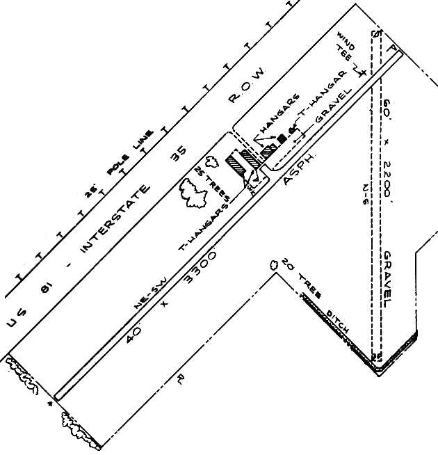
The 1963 TX Airport Directory (courtesy of Steve Cruse)
depicted San Marcos as having a total of 5 hangars along the northwest side of Runway 4/22.
The airport manager was listed as A. Churchill,
and the operators were listed as Gafford Aero Repair & San Marcos Aviation.

The 1964 USGS topo map depicted San Marcos Municipal Airport as having one paved northeast/southwest runway & an unpaved crosswind runway,
and 5 hangars along the northwest side.
After the much larger Gary AFB (northeast of the town of San Marcos) had been closed by the military
and became the new San Marcos Municipal Airport,
the original San Marcos Municipal Airport was sold to Robert Lowman in late 1966,
and the field was renamed Robert Lowman Airport in 1967 (according to David Brooks).
Lowman Airport was depicted on the 1968 San Antonio Sectional Chart (courtesy of David Brooks)
as having a single 3,300' paved runway.

A 5/31/68 photo by George Wilhite of his Piper J-3 Cub (NC70455) parked by the fuel pump at Lowman.
George recalled, “Gafford Aero (Joe Gafford A&P/IA/pilot) was the FBO operator who rented hangars, sold fuel & did aircraft maintenance.”

A 1973 aerial view depicted Lowman Airport as having a single paved northeast/southwest runway,
along with the unpaved crosswind runway.
Several hangars were located on the northwest side of the field,
around which could be seen a total of 7 light aircraft.

A May 1975 aerial view by George Wilhite looking east at Lowman Field,
“shows the damage from a wind & rain storm from the night before.”
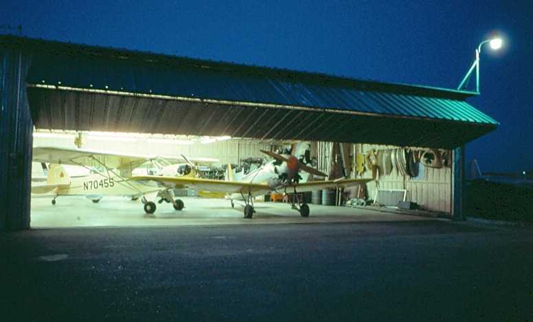
An August 1975 photo by George Wilhite of a nighttime view into a Lowman Field hangar,
“looking toward the lighted hangar highlights my Cub & Mr. Emmett McCoy's PT-22 (it possibly carried the Navy designation).”
Lowman Airport was still depicted on the 1980 San Antonio Sectional Chart (according to David Brooks).
Robert Lowman Airport was still listed as an active airfield in the 1982 AOPA Airport Directory (courtesy of Ed Drury),
and described as having a single 3,300' asphalt Runway 4/22 & a 2,200' gravel Runway 17/35.
Lowman Airport was apparently closed (for reasons unknown) at some point in 1982,
as it was marked “Closed” on the 1982 San Antonio Sectional Chart (according to David Brooks),
and was no longer listed among active airfields in the 1985 TX Airport Directory.
A 1986 aerial photo showed that the outline of both former runways was still perceptible,
but all of the pavement of the former Runway 4/22 had been removed except for a small portion along the northeast end,
which still had a closed runway "X" marking at its very end.
The former hangars still remained standing,
and were apparently being reused for some commercial purpose.

The 1995 USGS aerial photo showed the site to remain in the same status as seen in 1986.
Garry Mangum recalled of the original San Marcos Airport,
"It was used for some time after it closed as a general aviation field for the flight of radio-controlled aircraft.
I flew there at couple of events on Memorial Day weekend during the late 1990s.
It sadly had to close also due to development."
The former airfield was no longer depicted at all (even as an abandoned airfield) on the 1998 World Aeronautical Chart.
In a circa 2006 aerial photo of the site of the original San Marcos Municipal Airport,
the outline of both former runways were still perceptible.
The former hangars also still remained standing.
The airfield site is located south of the intersection of Interstate 35 & Redwood Road.
____________________________________________________
Austin Robert Mueller Airport (AUS), Austin, TX
30.3, -97.7 (Northeast of Downtown Austin, TX)
“Austin Airport”, as depicted on The 1929 Rand McNally Air Trails Map (courtesy of Chris Kennedy)
In 1928 voters approved bonds to build Austin's first municipal airport.
The City Council purchased 340 acres for $60,785
on a site outside of the city selected by Army Lt. Claire Chennault (later commander of WW2's famed Flying Tigers).
The earliest depiction which has been located of Austin Mueller Airport
was on the 1929 Rand McNally Air Trails Map (courtesy of Chris Kennedy).
It described “Austin Airport” as being located 3.75 miles northeast of the city center, and being 340 acres in size.
It was a municipal field, operated by the city.
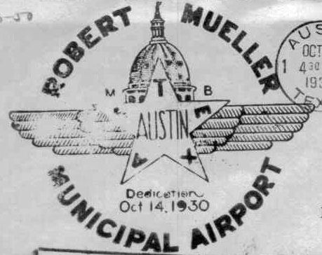
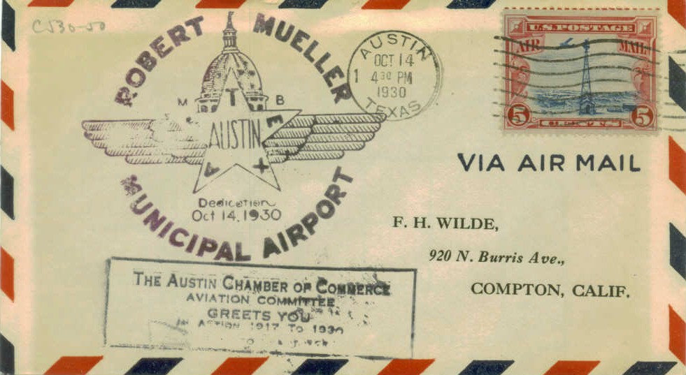
A postmark commemorated the 10/14/30 Dedication of Robert Mueller Municipal Airport.
Robert Mueller Municipal Airport opened on 10/14/30,
named for a prominent citizen & city commissioner who died in office in 1926.
The new airport featured a single runway, small office/terminal building, and one bow-trussed hangar.
Braniff International began Austin's first scheduled commercial air service on 1/1/36.
The earliest aeronautical chart depiction which has been located of Robert Mueller Airport was on the 1934 Austin Sectional Chart.

An aerial view of Austin Mueller Airport,
from the Airport Directory Company's 1938 Airport Directory (courtesy of Chris Kennedy).
The directory described Austin Mueller Airport as consisting of a 2,600' sod square landing area,
within which was a single 1,800' gravel runway.
The aerial photo in the directory depicted a single hangar on the field.

An 8/27/40 aerial view of Austin Mueller Airport (courtesy of Rob Schmidt)
showed that a 2nd longer paved runway had been added at some point between 1938-40.
A single hangar was located on the north side of the field.
A new terminal building opened at Mueller in 1942.
During WW2, Austin Mueller served as one of 4 auxiliary airfields used by nearby Bergstrom AAF.

Austin Mueller Airport, as depicted on the July 1943 Austin Sectional Chart (courtesy of Richard Doehring).
A circa 1950s aerial view of Austin Mueller Airport (courtesy of Rob Schmidt)
showed a dramatic expansion of the airfield facilities compared to the 1940 photo,
with 2 much longer runways having been added on the west side of the field,
along with 3 rows of hangars on the northeast side, along with another hangar on the southwest side.

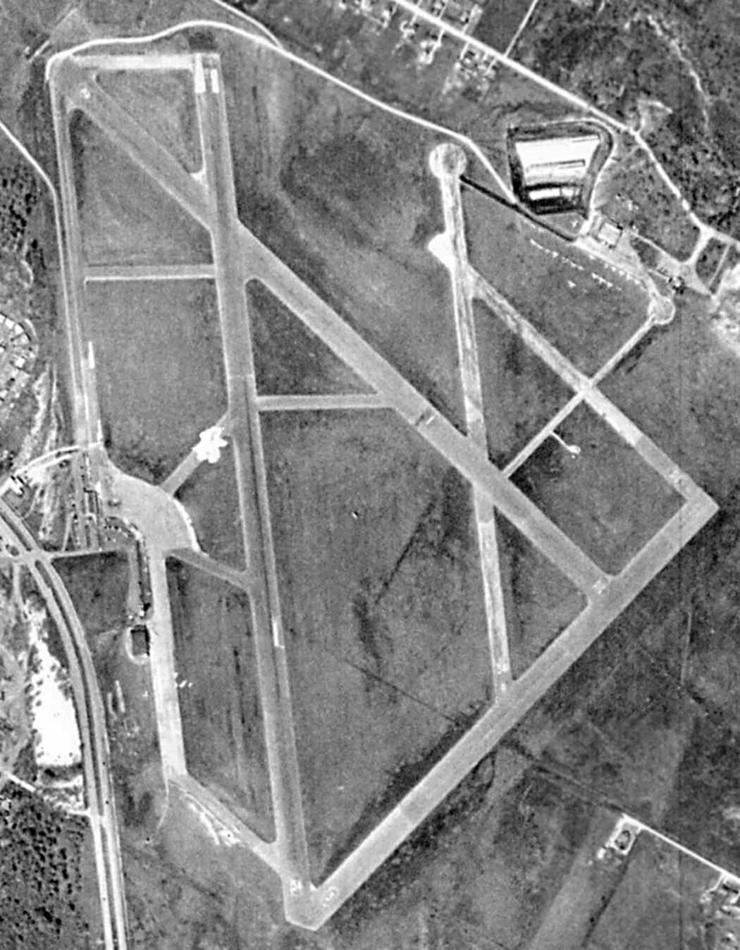
The 1954 USGS topo map depicted Austin “Municipal Airport” as having 5 paved runways, and numerous taxiways & hangars.
It also depicted the original terminal, on the west side of the field.
In 1956 the city extended Mueller's runway to 7,629' to accommodate jet traffic.
The original site was expanded to 711 acres by acquiring adjoining land, including the farm belonging to Roy Aldrich.
David Brooks recalled, "I flew hundreds of times in & out of Austin over many years (1957-91).
I did fly there as a private pilot & a passenger (mainly) on commercial aircraft.
The original 'new terminal' only had a covered walkway out to the planes
from the central building with its distinctive scalloped roof front.
It was that way up to 1968 as I have a picture of me leaving on a Braniff BAC-111 from the 'gate 1'.
The original terminal was to the side corner which was a wood building, not too much.
At that time, Austin only had about 15-25 flights per day.
When I was going to the UT, my first commercial flight was from there aboard a Braniff CV240.
During the late 1950s, Continental introduced 2 daily Viscounts - first jets into Austin.
I flew on the Viscounts from Austin to Houston on visits to relatives in Houston.
Otherwise, you had Trans Texas’s DC-3s.
Braniff flew on 'large' DC-6 per day into Austin from Dallas Love.
Braniff had about 9 flights per day Dallas to Austin (mainly) & Austin to San Antonio.
Occasionally they operated non-stop to Corpus Christi.
Trans Texas flew to Houston Hobby & Dallas Love.
Continental flew to Houston Hobby, San Angelo, and Midland/Odessa.
While President Johnson was in office during the 1960s,
Braniff flew a single daily non-stop from Austin to Washington Dulles using a Boeing 727-100."
David continued, "There was a viewing area on the terminal part of the building
with stairs you could go up & watch the comings & goings.
They had a total of 5 gates. Just a fence gate to go through to board the aircraft.
During the late 1950s to the early seventies, the principal air carriers serving Austin
were Braniff, Continental & Trans Texas (Texas International later).
That was the choices during regulation days of the FAA."

An early 1960 aerial view looking north at the new Austin Mueller terminal under construction.
The terminal building itself was complete, although work was still underway on the apron & gate pier.
Robert Mueller Airport opened its new 'jet age' passenger terminal in 1960 to replace a much older temporary building.
Although jet service from the airlines serving Austin (Braniff, Trans-Texas & Continental) was still many years off,
the terminal was hailed as a modern showplace for the fast new aircraft.
Never mind that the 707 & DC-8 aircraft couldn't operate from the short runways at the airport!
The building was single-story, with ticketing at the north end & baggage claim to the south.
A full-service restaurant, passenger lobby, newsstand & gift shop were located in between the two,
a design typical of mid-size terminals of the era.
Extending across the apron from the lobby was an open-air passenger pier with parking for 8-10 aircraft.
All boarding was at ground level.
The architecture of the building, in contrast to the layout, was definitely eye-catching.
The main terminal featured a series of waving roof trusses designed to mimic clouds.
Glass walls & landscaped planters inside created a pleasant atmosphere for departing & arriving passengers.
Perhaps the most notable feature of the building, however, was the control tower -
a graceful, curved structure paneled in blue & white, with the cab at the top.
The tower quickly became the terminal's - and one of the city's - most recognizable features.
In 1961 the new Mueller terminal & iconic control tower were dedicated in a ceremony
attended by Vice President Lyndon Johnson & Mayor Lester Palmer.
By the time of the 1963 TX Airport Directory (courtesy of Steve Cruse),
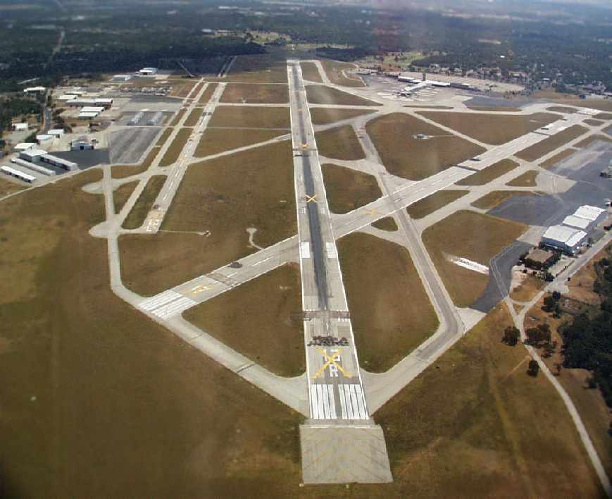
Mueller had a total of 5 paved runways (the primary runway, 12R/30L, was 7,300'),
as well as numerous taxiways, ramps, hangars, and a terminal with control tower.

The 1966 Austin Sectional Chart (courtesy of John Price) depicted Mueller as having a longest runway of 7,300'.
By the end of the 1960s, all 3 airlines had introduced jet services at the airport,
Braniff with 727s, Texas International with DC-9s, and Continental with a mix of the 2 types.
In the early 1970s, the airport underwent its first major expansion,
in the form of a second-floor boarding area over the airside pier.
A new sloping ramp was built connecting the main terminal with 6 upper-level gate holdrooms, all equipped with jetway loading bridges.
Braniff operated from the 3 gates on the south side of the pier,
while Continental & Texas International shared the 3 north-side gates.
The baggage claim area was also extended & carousels installed.
Larry Dunbar recalled, “When I first came to Austin in 1974, I had a job that took me by Muller on I-35 in the evening.
I recall Continental operating either a 707 or 720 on an evening flight into Austin at that time.
It was impressive to see a 4-holer on final at what seemed like 10' over the highway.”
Traffic really started to grow after deregulation in 1978.
Southwest Airlines began service that year, with flights to Dallas, Houston & Midland.
Following the Continental / Texas International merger & collapse of Braniff in 1982,
a slew of new airlines opened up routes to Austin -
Delta, American, United, USAir, Piedmont, America West, TWA, Ozark & Republic, among others.
A 5-gate 'rotunda' was added to the end of the passenger pier in the early 1980s to accommodate the extra airlines.
American & Delta took over this addition & remained its primary tenants until the terminal closed in 1999.

A circa 1980-85 aerial view of Mueller (courtesy of Steve Cruse).
In the mid-1980s, the city of Austin abandoned plans to construct a new terminal & parallel runway
and instead began searching for a site to build a replacement airport.
In the meantime, they approved a 'stopgap' bond package to allow for improvements at Mueller.

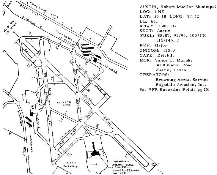
A 1987 diagram of Mueller's terminal.
Southwest, which had become the airport's largest carrier, opened its own 'unit terminal' in 1988.
Known as the East Terminal, it featured 4 jetway-equipped gates & a single large departure lounge,
constructed above new ticket counters & operations offices.
The arrival & departure roadways were also widened & redesigned.
For a time during the early 1990s, American even operated DC-10s on the Austin-DFW run,
although these were later replaced by 757s & MD-80s.
The East Terminal was bursting at the seams with Southwest flights -
Austin had some of Southwest's fastest turnarounds as a result of pressure to accommodate incoming flights.
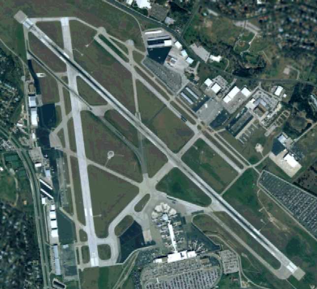
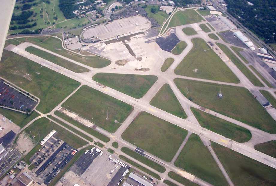
A circa late 1990s aerial view of Austin Mueller, while the field was still open.
In 1997 the State of Texas, after considering plans to take over Mueller & keep it open as an airport,
announced it would instead acquire 282 acres of the Mueller site for a new office complex.
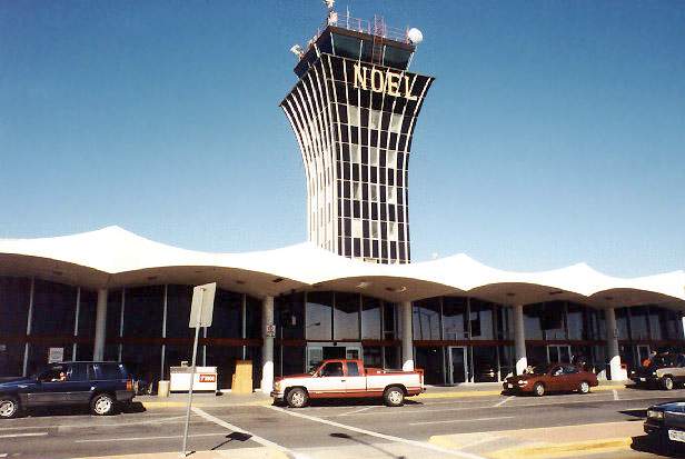
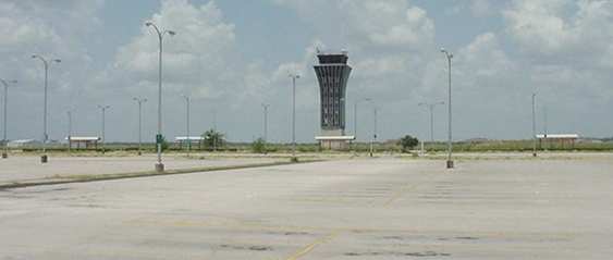
The tower at Austin Mueller, decorated for Christmas 1998, shortly before its closure.
Photo copyright Airnikon, used by permission.
After almost 40 years of operations, Austin-Mueller finally closed its doors in March of 1999
and all operations transferred to Bergstrom.
A circa 2000 aerial view by Bill Gunn looking looking southeast at Austin Mueller,
taken about one year after the the field was closed.
For several years after the closure, as the city finalized redevelopment plans,
the extensive aviation infrastructure at Mueller sat completely abandoned.
The Aircraft Owner's & Pilots Association had lobbied to reopen Mueller for general aviation use,
but this was an uphill battle.
The local government's redevelopment plan called for absolutely no future aviation uses,
but rather for homes & businesses to cover the site.

A 2001 photo (copyright Jason Knutson, used by permission) of the abandoned control tower at Austin Mueller.

A 2001 photo (copyright Jason Knutson, used by permission) of the abandoned Delta & American Airlines jetways at Austin Mueller.
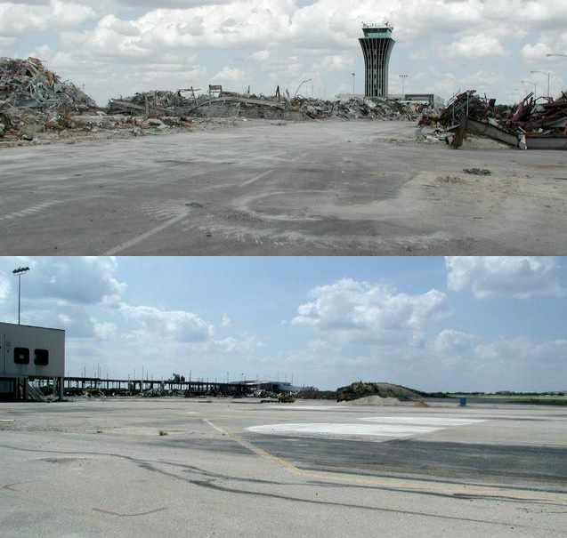
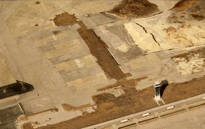
Two 2002 photos of the passenger pier being demolished at Austin-Mueller - a sad day in the former airport's history.
Major demolition & redevelopment of the Mueller site finally got underway in 2002.
The main pier & rotunda came down first, although Southwest's East Terminal has supposedly been removed as well.
The control tower will remain on the site as a memorial to the airport.
By September 2002, there was no trace of the pier area,
and the touchdown marks on the runways were beginning to fade as well.
A 2003 aerial view looking south at the remains of Austin Mueller Airport, by Dick Merrill.
Notice the terminal has already been completely removed.
What an incredible waste of infrastructure paid for by the taxpayers.
A 2003 photo by Scott Murdock of the Austin Mueller control tower.
Scott observed, "The control tower stands, as do the airport access roads with overhead signs,
and the parking areas with their access gates & tollbooths.
But the terminal building itself has been demolished, making an eerie setting."

A 2003 photo by Scott Murdock of a former Austin Mueller hangar.
In an incredible case of irony (and poor municipal planning!),
as of 2003, several elected Austin leaders were lobbying for Austin Mueller to be reopened,
as a general aviation reliever airport.
This would be to alleviate the lack of general aviation facilities in the Austin area,
now that Austin Executive Airport had been closed,
and the "new" Austin International Airport (the former Bergstrom AFB) offered extremely limited general aviation facilities.
They couldn't have just saved a lot of tax dollars & effort by keeping it open, could they?
All that aviation infrastructure, bought & paid-for, all gone to waste.
A circa 2005-2006 aerial view looking north at the odd sight of the former Austin Mueller control tower,
now standing alone, with the site of the now-demolished terminal building just behind it.
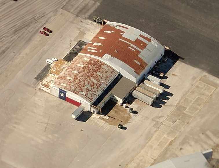
A circa 2005-2006 aerial view looking west at one of several former hangars remaining on the north side of the former field,
this one emblazoned with the TX flag on the side.

A 3/24/07 photo of a Mueller hangar, with “Browning” still visible across the top, in the process of demolition.
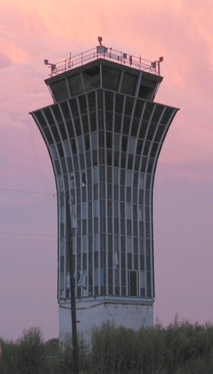
An 8/27/07 photo of Austin Mueller's control tower.

A 5/31/08 photo of Austin Mueller's control tower by Terry Keel.
Terry observed, “From this vantage you would be driving roughly west, the tower & now-missing terminal facility to the right,
new residential development on the old airport grounds straight ahead.”

A 11/25/09 aerial view looking northwest along the remains of Austin Mueller's Runway 31, all of which remained intact.
A new residential neighborhood covered the southwestern part of the airport.
A 11/11/15 photo by Ron Plante of a former Mueller Airport hangar.
Ron reported, “This field has been heavily developed, and if there is any pavement left I could not see it from the perimeter.
On the northeast side off Old Manor Road are 2 former hangars, but they’re inside the fence line & hard to view. Other structures could still be present.”

A 11/11/15 photo by Ron Plante of a former Mueller Airport control tower.
Ron reported, “On the south side, I was shocked to see the tower still standing next to rows & rows of new housing.
Similar new housing is going up on nearly the entire site.”
____________________________________________________
Since this site was first put on the web in 1999, its popularity has grown tremendously.
That has caused it to often exceed bandwidth limitations
set by the company which I pay to host it on the web.
If the total quantity of material on this site is to continue to grow,
it will require ever-increasing funding to pay its expenses.
Therefore, I request financial contributions from site visitors,
to help defray the increasing costs of the site
and ensure that it continues to be available & to grow.
What would you pay for a good aviation magazine, or a good aviation book?
Please consider a donation of an equivalent amount, at the least.
This site is not supported by commercial advertising –
it is purely supported by donations.
If you enjoy the site, and would like to make a financial contribution,
you
may use a credit card via
![]() ,
using one of 2 methods:
,
using one of 2 methods:
To make a one-time donation of an amount of your choice:
Or you can sign up for a $10 monthly subscription to help support the site on an ongoing basis:
Or if you prefer to contact me directly concerning a contribution (for a mailing address to send a check),
please contact me at: paulandterryfreeman@gmail.com
If you enjoy this web site, please support it with a financial contribution.
please contact me at: paulandterryfreeman@gmail.com
If you enjoy this web site, please support it with a financial contribution.
____________________________________________________
This site covers airfields in all 50 states.