
Abandoned & Little-Known Airfields:
Virginia: Western Richmond area
© 2002, © 2016 by Paul Freeman. Revised 2/27/16.
This site covers airfields in all 50 states: Click here for the site's main menu.
____________________________________________________
Please consider a financial contribution to support the continued growth & operation of this site.
Glenroy Airfield (revised 2/27/16) - Westview Airport (revised 10/21/06) - Virginia State Police Airport (revised 5/29/13)
____________________________________________________
Westview Airport, Richmond, VA
37.6, -77.51 (Northwest of Downtown Richmond, VA)
Westview Airport, as depicted on the July 1941 Norfolk Sectional Chart (courtesy of Chris Kennedy).
Photo of the airfield has not been located.
This short-lived general aviation field had the misfortune to be established just on the verge of WW2,
and thus lasted in operation only a mere one year.
According to the book "Virginia Airports" by Vera Rollo & Norman Crabill (published by the VAHS),
Westview Airport was formally opened on June 14, 1941.
It had been in use at this point for about 30 days.
The field was located on Horsepen Road between Broad Street & Monument Avenue.
The 200-acre site contained one 2,500' northeast/southwest runway,
although 2 others were planned (but never built).
Westview had a control tower, but it was apparently never used.
The field was quite often muddy.
The Westview School of Aviation offered flight instruction under the tutelage of Jeff Nolan.
Sightseeing, charter, and aircraft rentals were also offered.
The first women's flying club in Richmond was formed at Westview.
The earliest depiction of Westview Airport which has been located
was on the July 1941 Norfolk Sectional Chart (courtesy of Chris Kennedy).
It depicted Westview as a commercial/municipal field.

An undated diagram depicted Westview Airport as having 3 runways.
According to the book "Virginia Airports" by Vera Rollo & Norman Crabill (published by the VAHS),
Westview Airport closed in 1942 after the onset of WW2, after having been in operation for only one year.
It was not depicted at all on the 1942 USGS topo map.
Unfortunately, unlike many other small airports which had closed with the onset of the Second World War,
Westview never reopened after the end of the war.
It was no longer depicted at all on the 1945 Norfolk Sectional Chart (courtesy of John Voss)
or subsequent aeronautical charts.
A 1952 aerial view showed that the site had been covered by housing,
with not any trace remaining of the former Westview Airport.

As seen in a 2006 aerial photo,
it does not appear as if any trace remains of the former Westview Airport.
The site of Westview Airport is located south of the intersection of Horsepen Road & West Broad Street.
____________________________________________________
Virginia State Police Airport, Bon Air, VA
37.502, -77.541 (West of Richmond, VA)

The VA State Police Airport, as depicted on the July 1954 Norfolk Sectional Chart (courtesy of Chris Kennedy).
According to the Virginia State Police's web site,
the first 3 aircraft for the State Police were purchased in 1946,
and located in Pulaski, Lynchburg and Richmond.
A 1,650' landing strip was utilized at State Police Headquarters in Richmond.
The aircraft served the Department & other police agencies having need for air observation & transportation.
Missions included spotting fleeing felons, detecting whiskey stills, and observing traffic problems.
Troopers who were qualified as pilots performed these duties in addition to their regular assignments.
The earliest photo which has been located of the VA State Police Airport was a 1952 aerial view.
It depicted the field as having a northwest/southeast grass runway.
The earliest aeronautical chart depiction which has been located of the VA State Police Airport
was on the July 1954 Norfolk Sectional Chart (courtesy of Chris Kennedy).
It depicted the field as having an 1,800' unpaved runway.
The 1965 Norfolk Sectional Chart (courtesy of John Voss)
described the State Police Airport as having a single 1,800' turf runway.

The earliest photo which is available of the VA State Police Airfield is a 2/26/68 USGS aerial photo,
which depicted the field as having a single grass northwest/southeast runway.
William Drumright recalled, "In the 1972-74 time frame,
I flew with the Civil Air Patrol Squadron based in Hopewell.
It was from this field that we made at least one flight up to the State Police field on the outskirts of Richmond.
That flight was part of a training exercise with the scenario being that we were to land,
pickup some urgently needed blood in containers, and fly them to the desired location.
Our flight was conducted in a former Air Force L-19.
Getting into & out of the State Police field in that aircraft was no problem at all,
and it was the only time I landed there."

A 10/14/73 aerial view by Kenneth Keeton looking northwest at the VA State Police Airport.

The VA State Police Airport, as depicted on the 1975 Washington Sectional Chart (courtesy of Ed Drury).

The 1984 USGS topo map depicted the State Police Airport as having a single unpaved northwest/southeast runway.
In 1987, the State Police Aviation Unit moved into a hangar & separate offices at Chesterfield Airport,
at which point the State Police Airport on the grounds of the Headquarters was presumably closed.
The State Police Airport was no longer depicted on the 1991 Washington Sectional Chart (courtesy of Mike Keefe).

The 1994 USGS topo map depicted the State Police Airport as having a single unpaved northwest/southeast runway.

As can be seen in the 1994 USGS aerial photo,
several buildings have been constructed along the north & south ends of the former runway,
which is no longer really recognizable as a former airport.
The site of the State Police Airport is located at 7700 Midlothian Turnpike,
on the north side of Midlothian Turnpike.
____________________________________________________
Glenroy Airfield, Richmond, VA
37.565, -77.59 (Northwest of Downtown Richmond, VA)
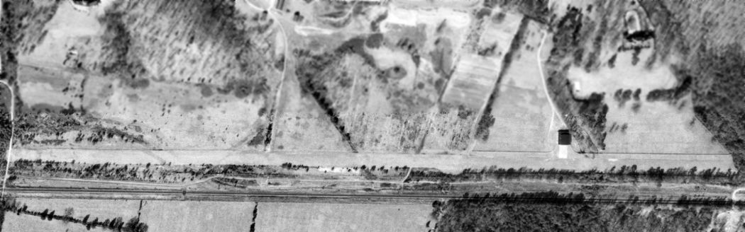
A 2/26/68 USGS aerial view of Glenroy Airfield.
According to Ray Tyson, Glenroy Field was owned by Fleetwood Garner,
and it may also have been known as Garner Field.
Garner was a very wealthy businessman who operated an Air Force training (contract) base at Bartow FL during the 1950s.
When his strip was 4,500' long it was located partly on his estate (Glenroy)
and the western approximately 1,000' on a Mr. West's property.
The earliest photo which has been located of Glenroy Field was a 2/26/68 USGS aerial view.
It depicted the field as having a single east/west grass runway, with a single hangar on the north side.
Glenroy was not yet depicted on the 1970 Washington Sectional Chart (courtesy of John Clifford).

The earliest aeronautical chart depiction of Glenroy Field which has been located
was on the 1972 Washington Sectional Chart (courtesy of Mike Keefe),
which depicted the field as having a 4,500' unpaved runway.

"Glenroy" Airfield, as depicted on the 1975 Washington Sectional Chart (courtesy of Ed Drury).
It was labeled simply "Landing Strip" on the 1984 USGS topo map.
Meade Daffron reported "I stumbled upon the Glenroy airfield while hiking along the James River in the early 1980s.
There was a small Cessna 150-type plane sitting outside the hangar.
The airfield was grass & bordered by split-rail fencing.
It appears to have been a private airfield owned by the property owner."
The Glenroy Airfield was evidently closed at some point between 1975-91,
as it was no longer depicted on the 1991 Washington Sectional Chart (courtesy of Mike Keefe)
or the 1994 USGS topo map.

A 3/11/94 USGS aerial view looking northwest showed Glenroy to have a single 4,000' east/west runway.
A single hangar sat adjacent to the north side of the runway, somewhat east of the midpoint.

A 1997 aerial view looking north at the field, by T. Fleetwood.
The date of closure of the Glenroy airfield is unknown.
It was not depicted at all (not even as an abandoned airfield) on the 2003 Washington Sectional Chart.

A circa 2001-2005 aerial view looking north at the hangar which remains at the site of the former Glenroy Airfied.
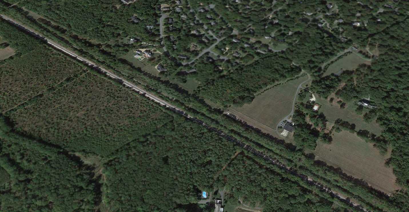
A 2014 aerial view looking northwest at the runway & hangar at the site of Glenroy Airfied.
The Glenroy Airfield is located at the southern terminus of Westoe Road,
just north of the CSX Railroad tracks & the James River.
____________________________________________________
Since this site was first put on the web in 1999, its popularity has grown tremendously.
That has caused it to often exceed bandwidth limitations
set by the company which I pay to host it on the web.
If the total quantity of material on this site is to continue to grow,
it will require ever-increasing funding to pay its expenses.
Therefore, I request financial contributions from site visitors,
to help defray the increasing costs of the site
and ensure that it continues to be available & to grow.
What would you pay for a good aviation magazine, or a good aviation book?
Please consider a donation of an equivalent amount, at the least.
This site is not supported by commercial advertising –
it is purely supported by donations.
If you enjoy the site, and would like to make a financial contribution,
you
may use a credit card via
![]() ,
using one of 2 methods:
,
using one of 2 methods:
To make a one-time donation of an amount of your choice:
Or you can sign up for a $10 monthly subscription to help support the site on an ongoing basis:
Or if you prefer to contact me directly concerning a contribution (for a mailing address to send a check),
please contact me at: paulandterryfreeman@gmail.com
If you enjoy this web site, please support it with a financial contribution.
please contact me at: paulandterryfreeman@gmail.com
If you enjoy this web site, please support it with a financial contribution.
____________________________________________________
This site covers airfields in all 50 states.