Abandoned & Little-Known Airfields:
Southwestern Wisconsin
© 2002, © 2016 by Paul Freeman. Revised 8/14/16.
This site covers airfields in all 50 states: Click here for the site's main menu.
____________________________________________________
Please consider a financial contribution to support the continued growth & operation of this site.
Dodgeville Municipal Airport (revised 12/5/14) - Gonstead Airport (revised 10/9/15) - Jackson County Airport (revised 11/23/15)
Joshua Sanford Field Airport (added 8/14/16) - Platteville Airport (revised 12/5/14)
____________________________________________________
Joshua Sanford Field Airport (KHBW), Hillsboro, WI
43.657, -90.328 West (West of Milwaukee, WI)
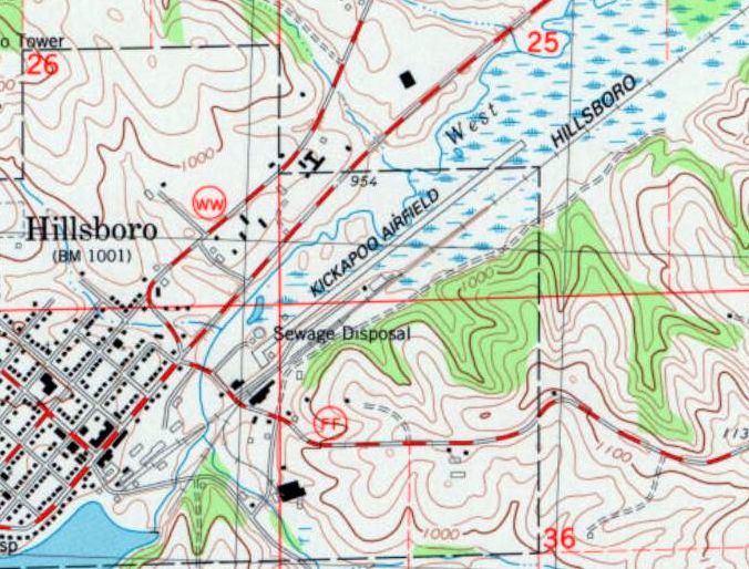
Kickapoo Airfield, as depicted on the 1983 USGS topo map.
According to its FAA Airport/Facility Directory data, this airport was activated in November 1972.
The earliest depiction which has been located of Kickapoo Airfield was on the 1983 USGS topo map.
It depicted Kickapoo as having a single paved northeast/southwest runway, with 2 small buildings on the southwest side.
An article entitled “Butter plant expansion leads to demise of Hillsboro airport” by Barry Adams in the 8/14/16 Wisconsin State Journal (courtesy of Bill Schlafer) reported,
“The airport in Hillsboro began as a pea gravel strip, has been both private & public over the years & was used by the Kickapoo Oil Co.
The airport was taken over by the city in the 1980s & in 1993 was named after Joshua Sanford, a Native American World War II fighter pilot.
He was twice wounded but highly decorated for his flying exploits that included 102 combat missions.
He was also officially credited with downing 8 enemy planes & was shot down or ditched his own plane 12 times.”
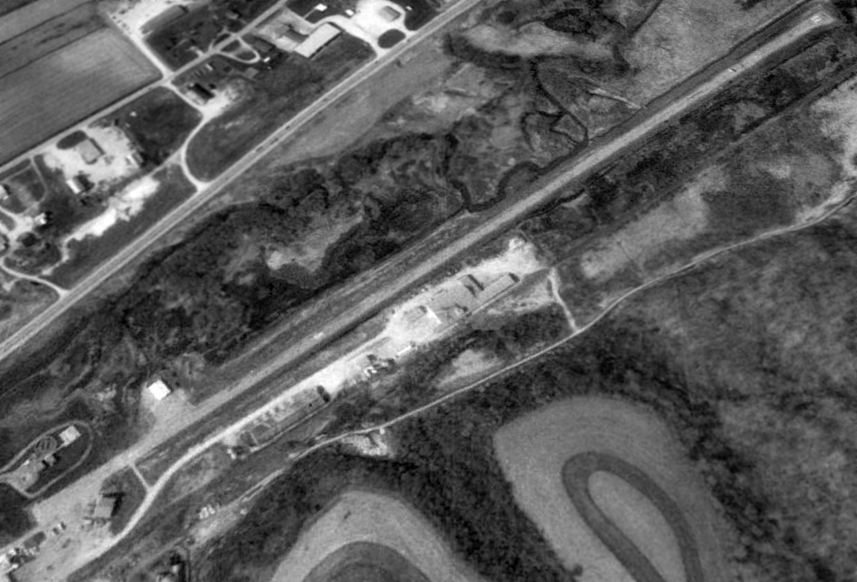
The earliest depiction which has been located of Joshua Sanford Field was a 1992 USGS aerial view looking north.
It depicted Sanford as having as a single paved northeast/southwest runway, with 2 small buildings on the southwest side.
There were no aircraft visible on the field.
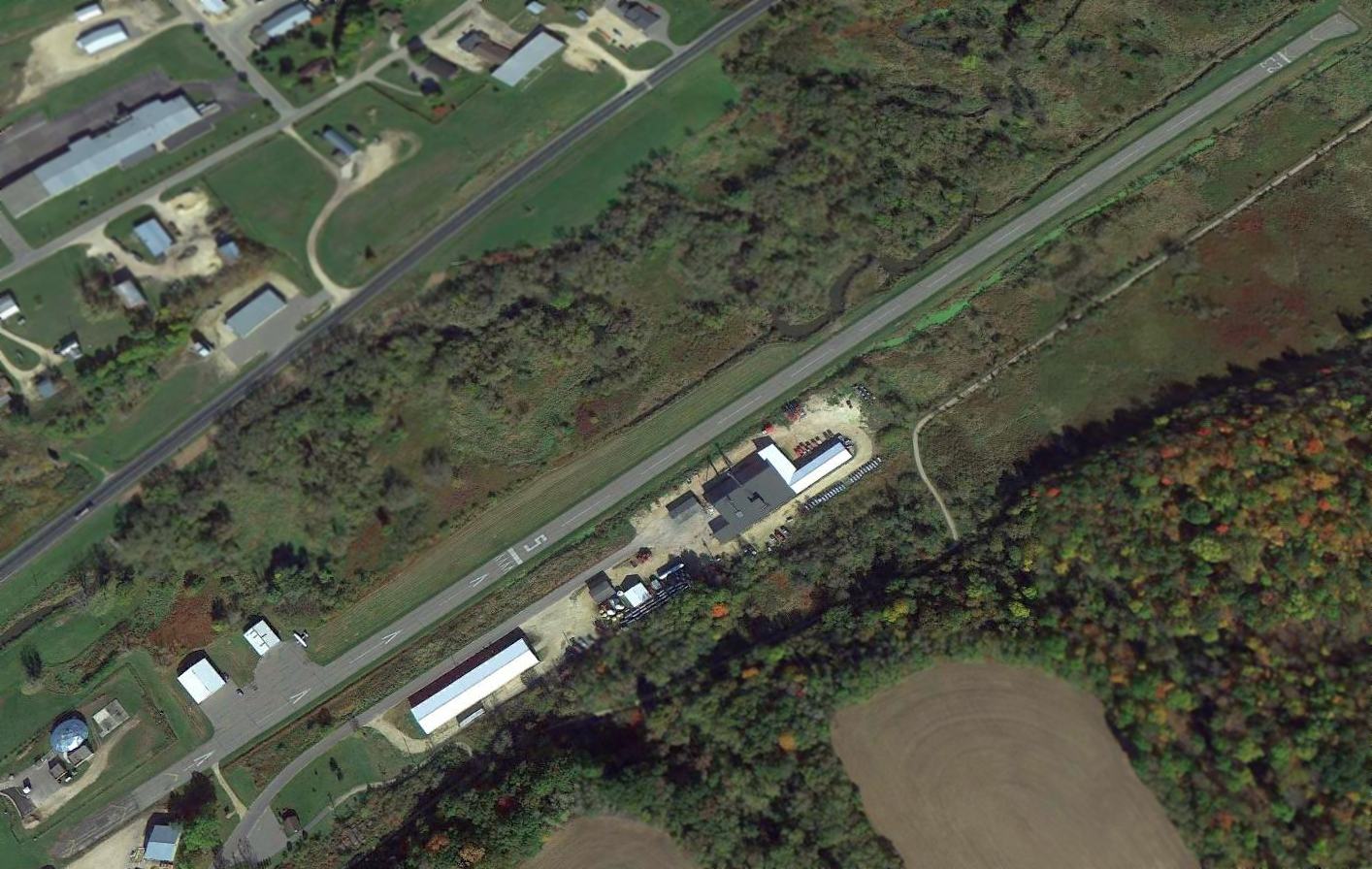
A 2013 aerial view looking north showed 1 Cessna outside a hangar on the southwest side of Joshua Sanford Field.
According to Joshua Sanford Field's FAA Airport/Facility Directory data, it conducted an average of 27 takeoffs or landings per week as of 2015.

The 2015 WI Airport Directory depicted Joshua Sanford Field as having a 3,070' paved Runway 5/23.
As of 2016, Joshua Sanford Field's FAA Airport/Facility Directory data described it as having a single 3,070' asphalt Runway 5/23, in “fair condition”.
The owner was listed as the City of Hillsboro, and the manager as Henry Peterson.
Joshua Sanford Field was said to have 7 single-engine aircraft based on the field.
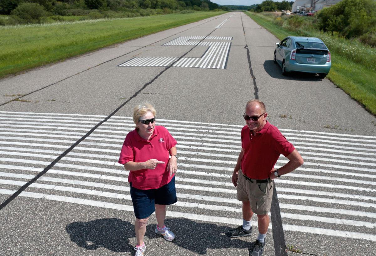
A 2016 photo by M.P. King of Patti Bruha, a student of Certified Flight Instructor & former airport manager Henry Peterson, on Joshua Sanford Field's Runway 5.
An article entitled “Butter plant expansion leads to demise of Hillsboro airport” by Barry Adams in the 8/14/16 Wisconsin State Journal (courtesy of Bill Schlafer) reported,
“There is no lack of quaintness at the Joshua Sanford Field Airport.
Those who land at the city-owned airstrip are asked to sign in on a faded yellow legal pad protected by Plexiglas in a self-serve kiosk constructed by Ian Collins, an Eagle Scout with Boy Scout Troop 83.
The plaque doesn’t say in what year Collins built the structure.
The 3,600' paved, lighted runway hasn’t been resurfaced in nearly 20 years & is sprouting weeds.
There is no terminal, maintenance shed or a place to buy fuel - just 2 hangars that over the last few years have housed only a few aircraft.
And while the number of regular users at the airport can be counted on 2 hands, it’s not uncommon for those that do land to walk across the street for rings of bologna,
2-pound rolls of butter & chunks of Muenster, Swiss & Colby at Janet Helgerson’s Cheese Store & More.
This is where a sign above the 3-door cheese cooler states 'We ID Limburger Cheese Customers!'”

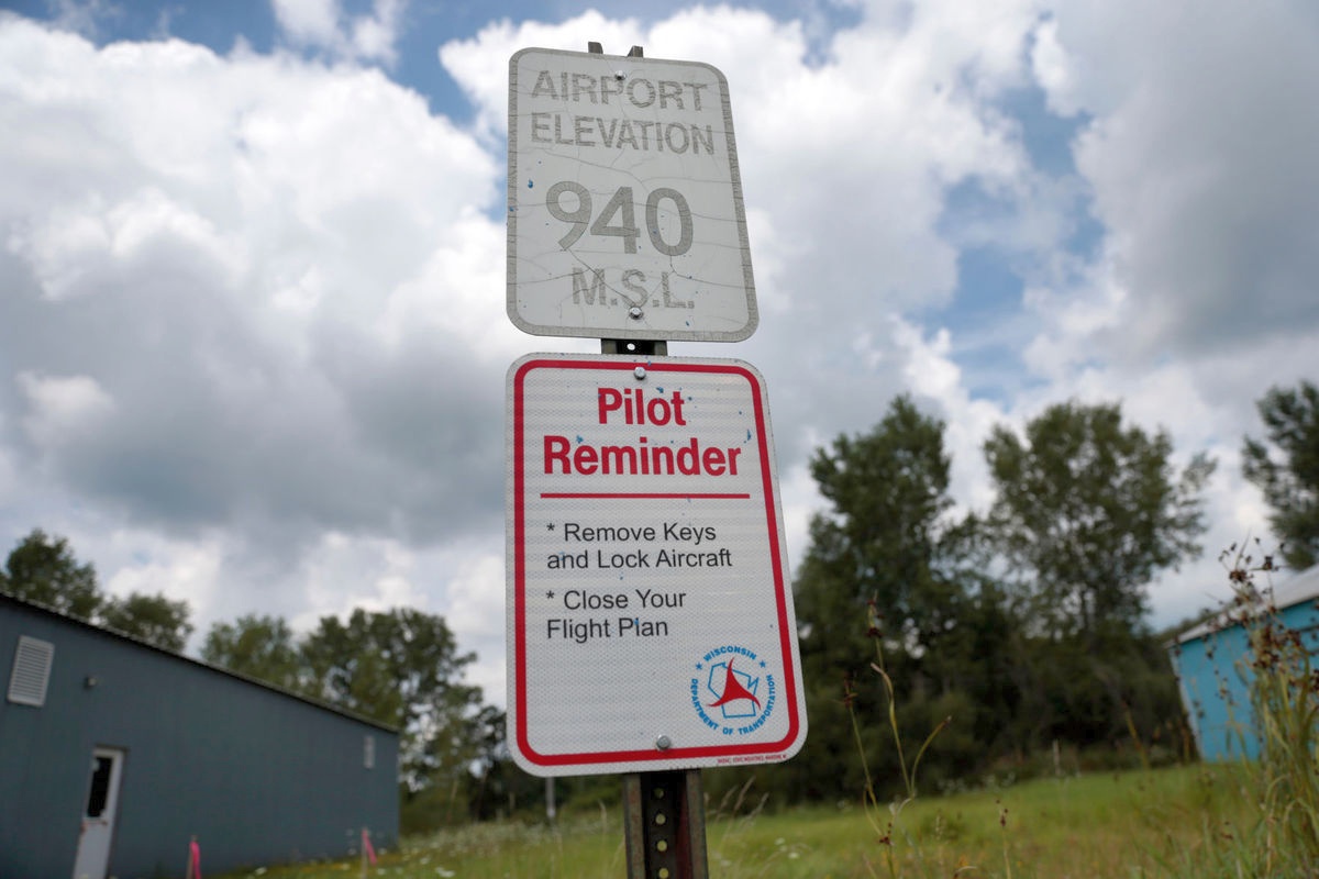
A 2016 photo by M.P. King of a sign which instructs pilots to sign a log book at Joshua Sanford Field Airport.
A gravel road leads to the 2 hangars in the background.
An article entitled “Butter plant expansion leads to demise of Hillsboro airport” by Barry Adams in the 8/14/16 Wisconsin State Journal (courtesy of Bill Schlafer) reported,
“But there are mixed feelings in this Vernon County city of about 1,400 people about a project at the Land O’Lakes butter factory
that is bringing economic development to the community.
The plant, purchased earlier this year by Land O’Lakes, makes quarter-pound, one-pound & 55-pound blocks of butter along with vats of butter oil used by commercial bakers & candy makers.
But the facility is located at the southwest end of the airport’s runway, and an addition will create a safety hazard for airplanes.
That has forced the city to close the little-used airport in exchange for jobs & tax base.

A 2016 photo by M.P. King of butter factory construction, with Joshua Sanford Field's Runway 5/23 in the background.

A 2016 photo by M.P. King of a runway light next to Joshua Sanford Field's Runway 5/23.
An article entitled “Butter plant expansion leads to demise of Hillsboro airport” by Barry Adams in the 8/14/16 Wisconsin State Journal (courtesy of Bill Schlafer) reported,
“In January, the Hillsboro City Council approved a memorandum of understanding & a development agreement with Land O’Lakes.
The city then floated a plan to close part of the runway & make it a restricted-use facility,
but the hangar owners, Henry Peterson & Bill Lesnjak, threatened to sue the city, saying it would affect their operations.
They dropped their case when Land O’Lakes paid Peterson $60,000 & Lesnjak $29,000 for their hangars that are in a flood plain thanks to the nearby West Branch of the Baraboo River.
The state Bureau of Aeronautics urged the city to prevent any incompatible land uses but had concerns about adding new structures & moving the runway protection zone.
The Federal Aviation Administration also studied the issue & told the city that a hazard designation could only be removed if the 40' tall Land O’Lakes addition was only 6' tall.
So, after months of debate & haggling, the city informed the state late last month that it was closing the airport.
Bulldozers were at work last week moving earth for construction at Land O’Lakes,
but mowing has stopped alongside the runway & takeoffs & landings will be prohibited by this fall.”
“Was it an easy decision? No,” said Adam Sonntag, Hillsboro’s city administrator.
“This has been 6 months of trying whatever we could in working with the state (Bureau of Aeronautics) & working with the FAA to come to some sort of reasonable solution.
It was frustrating. These things have existed next to each other for the last 30 years & all of a sudden they can’t because somebody wants to add to it? It doesn’t make any sense to us.”
It’s unclear what will become of the airport property, which is along a bike trail.
The flood zone eliminates the potential for development, although Sonntag said it could be used as parkland, a test track or for other uses that require minimal facilities.

A 2016 photo by M.P. King of butter factory construction immediately off the end of Joshua Sanford Field's Runway 5/23.
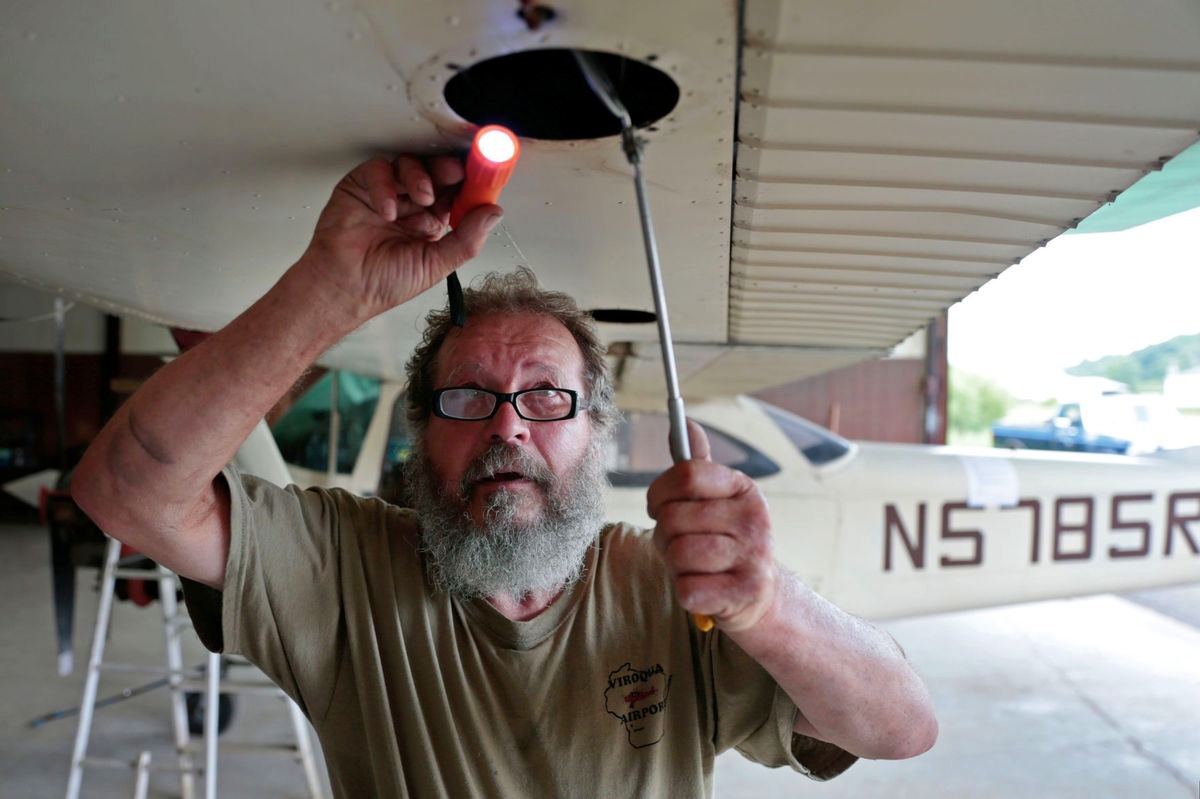
A 2016 photo by M.P. King of Frank Kablau inspecting the inside of a wing on his 1965 Cessna 172 Skyhawk inside a hangar he rents at Joshua Sanford Field Airport.
Kablau, 67, said he will move his plane to a hangar in Mauston once his plane passes inspection.
Kablau, a retired aircraft & bicycle mechanic, moved to the area in 2003, but is disappointed with the decision to close the airport that is a nine-minute drive from his 210-acre property northwest of the city.
“It’s ridiculous,” Kablau said. “We have plenty of runway here. It’s just silly to close it.”

A 2016 photo by M.P. King of a Cessna sign & a headset hanging in a hangar at Joshua Sanford Field Airport.
“I am deeply saddened that proposed construction by your company is going to be at the expense of our local airport,”
Patti Bruha wrote in an open letter dated 7/11/16 to Land O’Lakes & sent to the FAA, city, state and media.
Bruha is training to get her pilot’s license. When she was in high school, she took an aviation course as did many of her classmates. Now she’ll have to go elsewhere to train.
“We want the tax base from Land O’Lakes. We want the jobs, the city needs that,” she said.
“But I think the city needs the airport, too. Can’t we just co-exist together?”
A 2016 photo by M.P. King of a sign near the 2 hangars at Joshua Sanford Field.
Peterson, who served as the airport’s manager, said he has moved his 2 Cessna airplanes to Reedsburg.
The change will make flying less convenient for him, while the closure of the airport will take away part of the city’s character.
“I know jobs are important. I’m a small businessman,” Peterson said as we walked the runway.
“There’s always traffic in & out of here. How lucky is a small town like Hillsboro to have an airport? Look at all the other communities that don’t have an airport.”

The 2016 Sectional Chart depicted Joshua Sanford Field as having a 3,100' paved runway & an NDB beacon.
Joshua Sanford Field is located east of the intersection of Water Avenue & East Madison Street.
Thanks to Bill Schlafer for pointing out this airfield.
____________________________________________________
Jackson County Airport, Vaudreuil, WI
44.305, -90.806 West (Northwest of Milwaukee, WI)

Jackson County Airport, as depicted on the 1958 USGS topo map.
This general aviation airport was evidently established at some point between 1953-58,
as it was not yet depicted on the 1953 USGS topo map.
The earliest depiction which has been located of Jackson County Airport was on the 1953 USGS topo map.

The only photo which has been located of the Jackson County Airport was a 5/1/66 USGS aerial view.
It depicted Jackson County Airport as having 5 unpaved runways, with a row of individual T-hangars on the north side.
No aircraft were visible on the field.

The 1966 USGS topo map depicted Jackson County Airport as having 5 unpaved runways, with 2 small buildings on the north side.
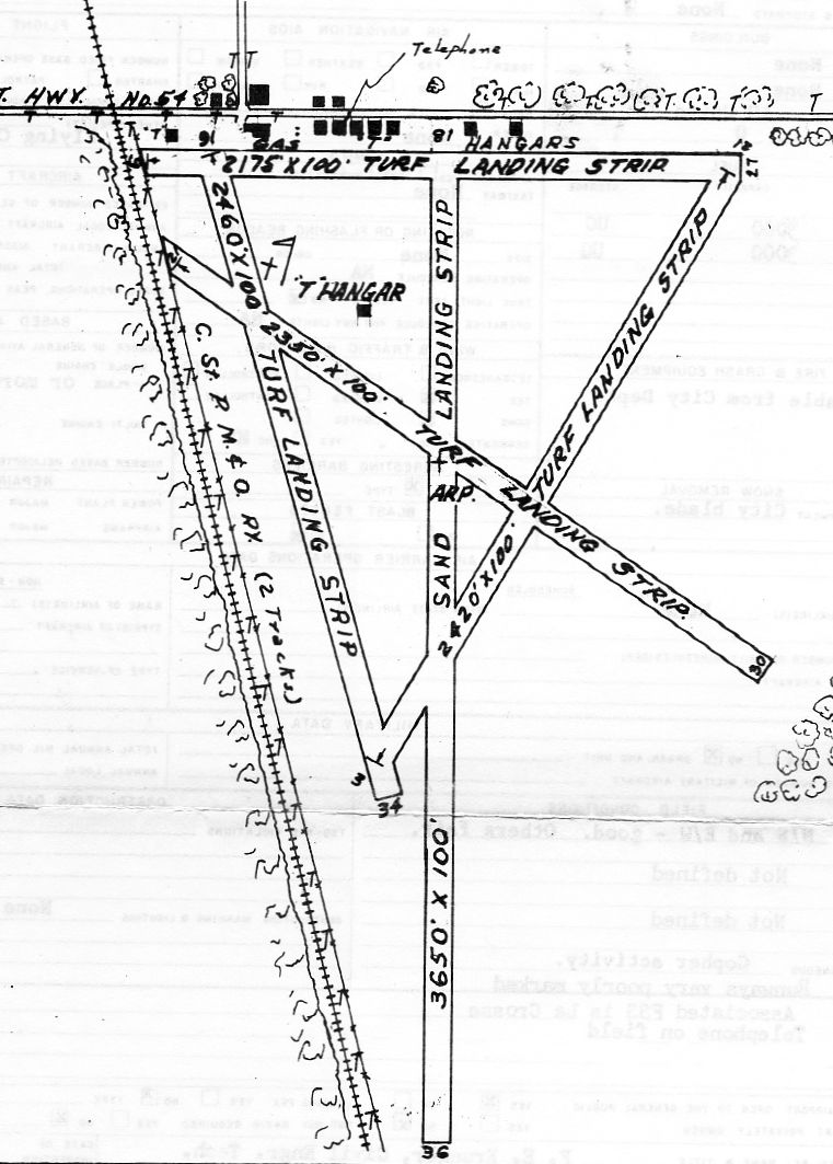
The last depiction which has been located of the Jackson County Airport was a 4/22/68 FAA Airport Facilities Record (courtesy of Dennis Baker).
It depicted Jackson County Airport as having 5 sand-turf runways, with the longest being the 3,650' Runway 18/36.
A row of T-hangars were depicted on the north side.
Jackson County Airport was evidently closed (for reasons unknown) at some point between 1968-83,
as it was no longer depicted on the 1983 USGS topo map.

Amazingly a 2013 aerial view looking south showed that several of the former small hangars remained standing along the north side of the Jackson County Airport site.
Streets & buildings covered the airfield site, and there was no recognizable trace of the 5 runways.
The site of Jackson County Airport is located on the south side of Airport Road, appropriately enough.
Thanks to Dennis Baker for pointing out this airfield.
____________________________________________________
Gonstead Airport, Mt. Horeb, WI
42.997, -89.74 (West of Milwaukee, WI)

A 11/23/60 USGS aerial photo of Gonstead Airport.
Clarence Gonstead was a chiropractic who eventually built a practice so large it had an adjacent motel to house patients.
Eventually he constructed an airfield as well.
According to Michael Abernethy, “It looks like it was built by the Gonstead clinic in the 1940s-1950s.”
According to gonstead.com, “Patients with their own private planes could fly in
and land at Gonstead’s personal airport located next to his home on the outskirts of Mount Horeb.”
The only photo which has been located of Gonstead Airport was a 11/23/60 USGS aerial photo.
It depicted a single paved north/south runway, with a ramp, a small building, and 4 single-engine aircraft on the southwest side.

The 1962 USGS topo map depicted Gonstead Airport
as having one paved north/south runway, with a small building on the southwest side.
The 1991 USGS topo map continued to depict Gonstead Airport in an unchanged fashion.
According to Michael Abernethy, Gonstead Airport, “officially closed sometime around 1992-93, to make way for a housing development.
Around February 1993, the airport was closed when an elderly lady was walking her dog on the closed runway
and was struck by the wing of a Piper Cub that had landed & was taxiing (the pilot had poor visibility once on the ground).
She sustained severe injuries. I picked her up & transported her to University of Wisconsin Hospital in Madison on the Med Flight helicopter.”
A 2000 USGS aerial view showed that houses had covered the site, with no trace remaining of Mt. Horeb Airport.

A 2013 aerial photo showed no trace remaining of Gonstead Airport.
The site of Gonstead Airport is located at the intersection of South 2nd Street & Gonstead Road.
Thanks to Michael Abernethy for pointing out this airfield.
____________________________________________________
(Original) Platteville Airport (C46), Platteville, WI
42.672, -90.5 (West of Milwaukee, WI)
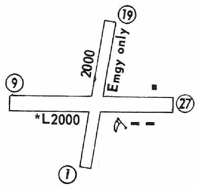
The original Platteville Airport, as depicted on the June 1962 Dubuque Sectional Chart (courtesy of Chris Kennedy).
The original airport for the town of Platteville was located 4 miles south of the town.
The original Platteville Airport was evidently established at some point between 1945-62,
as it was not yet listed among active airfields in the 1945 AAF Airfield Directory (courtesy of Scott Murdock).
The earliest depiction of the field which has been located
was on the June 1962 Dubuque Sectional Chart (courtesy of Chris Kennedy).
It described Platteville Airport as having a 2,000' unpaved runway.
The 1962 AOPA Airport Directory described Platteville Airport as having a single 2,000' sod Runway 9/27,
and listed the operator as William Nodorft.
The 1971 Flight Guide (courtesy of Chris Kennedy).
depicted the original Platteville Airport as having a 2,200' unpaved Runway 9/27,
along with a 2,000' unpaved Runway 1/19 (which was labeled as being for "Emergency only".
A few small buildings were depicted on the northeast & southeast sides of the field.

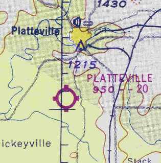
The May 1971 Chicago Sectional Chart (courtesy of Chris Kennedy).
depicted the original Platteville Airport (southwest of the town) as having a 1,700' unpaved runway.
It also depicted the new Plateville Municipal Airport,
which had been constructed a few miles to the northeast.

The 1972 USGS topo map depicted Platteville Airport as having an east/west unpaved runway.

The earliest photo which has been located of the original Platteville Airport was an 8/4/72 USGS aerial photo.
It depicted the field as having a paved east/west runway & an unpaved crosswind runway.
Kevin Kuchar reported that he learned to fly at the original Platteville Airport.
He recalled, “The time period was the middle to late 1970s
and was a Fixed Base Operation owned & operated by Dale Nodorft.
Dale was an FAA flight examiner as well as lead of a great bunch of instructors.”

Platteville's primary east/west runway had apparently been paved at some point between 1971-80,
as the 1980 Flight Guide (courtesy of Chris Kennedy) depicted the field as having a 2,200' paved Runway 9/27,
along with a 1,500' unpaved Runway 1/19.
A parachute drop zone was depicted on the northwest side of the field,
anda few small buildings were depicted on the northeast & southeast sides of the field.
The 1982 AOPA Airports USA directory (courtesy of Ed Drury)
described Platteville as having a 2,200' asphalt Runway 9/27 & a 1,550' turf Runway 1/19.
The operators were listed as Nodorft Aviation & Wizzard Radio.

The 1984 USGS topo map depicted Platteville Airport as having a single east/west runway.

In the 1995 USGS aerial photo, Platteville Airport appeared to still be open,
as the runway was not marked with any form of closed runway "X" markings.
The crosswind grass runway was quite noticeable in this picture.
Two hangars & several other smaller buildings were clustered around the eastern end of the runway.
The original Platteville Airport was closed by 1998,
as the 1998 World Aeronautical Chart only depicted the new Platteville Airport (a few miles to the east),
not the original field.

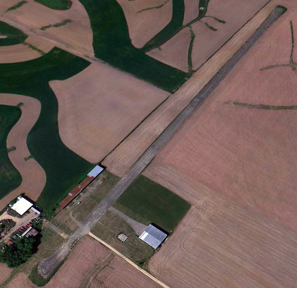
A June 2004 aerial photo by Robbie Culver, looking south at the former Platteville Airport, which is still completely intact.
Several vehicles appeared to be parked on the east end of the paved runway, which was otherwise intact.
The former grass crosswind runway also remained intact, and the hangars also remained standing.
As of 2004 the former Platteville Airport was being used by the Platteville Area Modelers for model aircraft flights.
A 2012 aerial view looking southwest showed the former Platteville Airport to remain intact.
The site of the original Platteville Airport is located southeast of the intersection of Loeffeholz Road & Airport Road,
appropriately enough.
Thanks to Robbie Culver for pointing out this airfield.
____________________________________________________
Dodgeville Municipal Airport (55C), Dodgeville, WI
42.995, -90.144 (West of Madison, WI)

What was then known as the "Governer Dodge-Quinn" Airport,
as depicted on the 1967 Milwaukee Sectional Chart (courtesy of Chris Kennedy).
The Dodgeville Municipal Airport was apparently built at some point between May-December 1967,
as it was not depicted on the May 1967 Milwaukee Sectional Chart (according to Chris Kennedy).
By the time of the December 1967 Milwaukee Sectional Chart (courtesy of Chris Kennedy),
it had appeared on the chart, labeled "Governer Dodge-Quinn".
It was described as having a 2,800' unpaved runway.
It was apparently renamed Dodgeville (and gained a paved runway) at some point within the next 3 years,
as the May 1970 Milwaukee Sectional Chart (courtesy of John Voss)
described Dodgeville as having a single 2,800' paved runway.
"Dodgeville Airport" was described in the 1971 Flight Guide (according to Chris Kennedy)
as having a single 2,800' hard-surface Runway 12/30.

An undated (circa 1970s?) photo of a Piper Warrior of Wenger Flying Service at Dodgeville Airport.
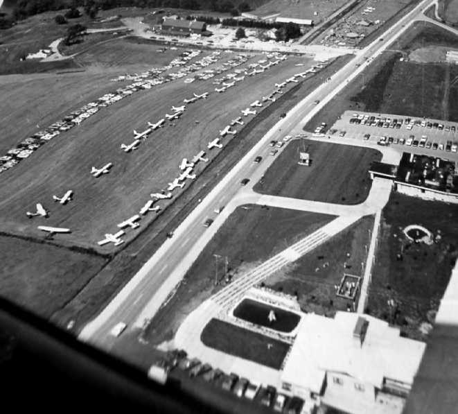
An undated aerial view of a very large number of light planes parked at Dodgeville Airport
(photographed in 2009 by Jason McDowell from a historical display at the Don Q Inn).

An undated aerial view of several light planes parked next to the Don Q Inn at Dodgeville Airport
(photographed in 2009 by Jason McDowell from a historical display at the Don Q Inn).

A 1977 photo of the C-97 on final approach for Dodgeville's little runway
(photographed in 2009 by Jason McDowell from a historical display at the Don Q Inn).
The most remarkable aspect of the Dodgeville Airport is its resident Boeing C-97G,
which serves as a static display at the Don Q Inn which sits adjacent to the south side of the airport.
Dodgeville's C-97G was built in 1952, and it has logged a total of 10,068 hours of flight.
This particular C-97G was used to film 2 commercials for the Mercury Cougar in 1975,
and Farrah Fawcett's autograph appears on the lower fuselage.
It was purchased in 1977 from a bankrupt company in Long Beach, CA.
Registered as N227AR, the C-97G was flown into the comparatively tiny 2,800' runway at Dodgeville in 1977.
Each main landing gear was 3' outside the edge of the runway, creating a large cloud of dust.
Upon touchdown, the plane was put into reverse thrust & the brakes applied to maximum,
stopping the C-97G just in the nick of time.
According to Dick Phillips (retired Northwest Airlines),
"The C-97G was flown into the field by Dick Schmidt.
He was an Air Force Reserve C-97 pilot & a Captain for Air Wisconsin.
I knew him quite well when I worked for Air Wisconsin back in the 1960s & 1970s."
Everett Hayes recalled of the C-97 at Dodgeville, “I saw it land in 1977!
I was coming past the airport & noticed a large crowd there.
I pulled into the parking lot & asked someone what was going on?
I was told that a large airplane was going to land very shortly & that it was purchased by the Don Q Inn for a display.
Well, we waited & waited & waited.
Finally, we could the huge motors in the distance, coming in from the direction of Madison.
Someone mentioned that they had landed these & emptied the fuel tanks, leaving just enough to get to Dodgeville.
It flew over head and circled, dropped the landing gear & extended the flaps.
It slowed up so much it looked as thought it was going to drop out of the sky.
They had police block off the state highway at the end of the runway in case it didn't stop in time.
Then it hit the runway & reversed it's props & made more noise & raised more dust than anything I had ever seen!
What a sight. It used up all the runway, but got stopped in time.”
Bill Zitner recalled, “The C-97 was the one used on the Mercury Cougar adds,
the one that showed all the cougars coming out of the nose.
Farrah Fawcett was in the commercial, and she signed the left side of the aircraft, between the port nose & door.
That was quite a sight seeing that come in. Unbelievable dust & dirt thrown up. The road was packed with onlookers.”
Dick Wobus recalled, “The C-97 had to wait several days at Madison, WI,
for sufficiently strong southeast winds so it would be able to land uphill at Dodgeville.
The engines were derated from the original maximum power because 115/145 octane fuel was no longer available & 100/130 had to be used instead.
One of the warnings that used to be listed for this airport was that the downward slope increased toward the NW end of the runway
so that the view from either end to the other was blocked.”
Scott Marshall recalled, “I used to fly out to the Dodgeville Airport in the mid-1970s to the mid 1980s.
The Don Q Inn had a great restaurant & you could park along the taxiway that led to the hotel very close to the C-97.
They had plans to turn it into a restaurant. I made many night landings there in my 172 & later on my V35 Bonanza.
Runway 30 started out level to slightly uphill for the first 600-700'. From that point on it was all downhill.
There was a drop off at the end that looked like it was used for a dump.
If you did not land on the first 700' at night you would get a surprise or worse if you were not ready for it.
I saw 2 damaged aircraft over the course of my visits & it may have been one of the reasons it closed.
When the inn was sold the new owners were probably concerned about liability.
The hotel was a very interesting place when Don Quinn owned it.
It had an underground tunnel to the restaurant that had strange dioramas & other things buried in the walls.
In it’s heyday it was the place to fly to & very romantic with various theme rooms & always seemed to be a work in progress. I really miss the place.”

The 1980 USGS topo map depicted Dodgeville Municipal Airport as having a northwest/southeast runway.
The 1982 AOPA Airport Directory (courtesy of Ed Drury)
described Dodgeville Municipal Airport in the same manner.
Ron Planterecalled, "I first saw the plane back in 1986-87.
I'm certain the airport was open at that time."
Dodgeville was depicted as a public-use airport
on the October 1986 & May 1987 Chicago Sectional Charts (according to Timothy Aanerud).
The 1989 Airport/Facility Directory included the remark: “CAUTION: Runway 12/30 steep down grade to the northwest.
Threshold of Runway 30 is 85' higher than Runway 12.”
Bill Zitner recalled, “The airport had quite a few incidences, especially the downhill westerly landings.
I flew in with a 150 & 172. The airport became private I think around 1990.”
The Dodgeville Airport apparently closed (for reasons unknown) at some point between 1989-90,
as it was no longer depicted at all on the May 1990 or April 1994 Chicago Sectional Charts (according to Timothy Aanerud).
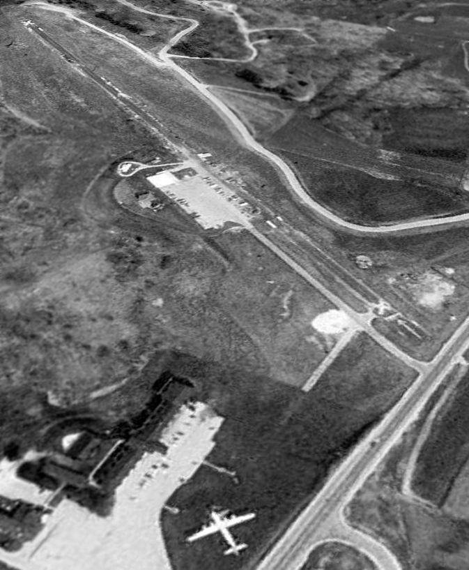
A 1995 USGS aerial view looking northwest showed the Dodgeville Airport runway was clearly marked with closed "X" symbols,
but the airfield was otherwise not redeveloped.
A paved ramp still existed along the south side of the runway,
and there appeared to be at least one hangar still standing on the western edge of the ramp.
Note the C-97G parked at the southeast corner.
The Dodgeville Airport was evidently reopened as a private airfield at some point between 1994-99,
as that is how it was depicted on the November 1999 Chicago Sectional Chart (according to Timothy Aanerud).
The Dodgeville Airport was still listed as a private airfield
on the May 2001 Chicago Sectional Chart (according to Timothy Aanerud).


A series of photos taken 2003 by Ron Plante of the C-97G which sits in front of the Don Q Inn,
adjacent to the south side of the former Dodgeville Municipal Airport.
Ron reported, "I went again yesterday to confirm the plane is still there but the airport is closed.
I went inside the C-97G again, and sadly it is not in good shape.
The plane is in front of the no-longer-glamorous Don Q Inn & Hotel."
He reported that the land of the former airport "now appears to be agricultural."

A 2009 photo by Jason McDowell looking south along Dodgeville's former north/south taxiway leading to the C-97, with the Don Q Inn on the right.
Bill Zitner reported in 2009, “Now there's a bunch of construction-type equipment around the east end of the strip.”

A 2013 aerial view looking northwest at the former Dodgeville Airport shows the runway to remain intact,
but it appears to be used to store a variety of items.
Note the C-97 remaining in the foreground.
____________________________________________________
Since this site was first put on the web in 1999, its popularity has grown tremendously.
That has caused it to often exceed bandwidth limitations
set by the company which I pay to host it on the web.
If the total quantity of material on this site is to continue to grow,
it will require ever-increasing funding to pay its expenses.
Therefore, I request financial contributions from site visitors,
to help defray the increasing costs of the site
and ensure that it continues to be available & to grow.
What would you pay for a good aviation magazine, or a good aviation book?
Please consider a donation of an equivalent amount, at the least.
This site is not supported by commercial advertising –
it is purely supported by donations.
If you enjoy the site, and would like to make a financial contribution,
you
may use a credit card via
![]() ,
using one of 2 methods:
,
using one of 2 methods:
To make a one-time donation of an amount of your choice:
Or you can sign up for a $10 monthly subscription to help support the site on an ongoing basis:
Or if you prefer to contact me directly concerning a contribution (for a mailing address to send a check),
please contact me at: paulandterryfreeman@gmail.com
If you enjoy this web site, please support it with a financial contribution.
please contact me at: paulandterryfreeman@gmail.com
If you enjoy this web site, please support it with a financial contribution.
____________________________________________________
This site covers airfields in all 50 states.