![]()
The Alexander Murray Hiking Trail offers much to the outdoor enthusiast including breath-taking scenery, a wide variety of plant and animal life, and also a wonderful workout. Approximately 8-10 kms in length, the trail can be completed in 3-4 hours depending on the amount of sightseeing conducted. For a more pleasurable experience, 4-6 hours.
For those not familiar with the town of King's Point, the trail's entrance is located directly across from the Harry Keats Memorial Softball field. The journey will begin from this point, where a variety of names will be seen along the way including Grouse Brook, Dole Road, Alan Newbury's Road, Smart's Grade, West Line, Moose Barrens, each with their own unique story, until the entrance to the Corner Brook Gorge becomes visible 3-4 kms later.
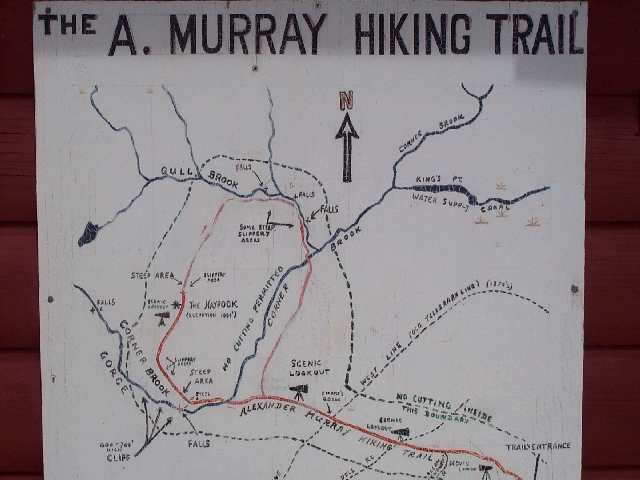
At this point one should not only be in full view of the gorge itself but also the hundreds of wooden steps which scale the steep mountainside. In addition, some of the main highlights of the journey should be visible including the North Ridge and the Haypook Summit. In this section of the trail a painted map is located at a "Y" branch in the main path. This map outlines some of the main features of the gorge and mountain area ahead. To the immediate left a separate trail emerges by which you will traverse when coming down from the Haypook (more about that later).
In order to reach the apex of the North Ridge one must endure the most harrowing part of the trek....climbing the steep mountainside on the right side of the Corner Brook Gorge. This has much improved in recent years with the construction of wooden steps to aid in the ascent. During this climb one will experience the echoing sound of the Corner Brook Gorge and may even take steep steps to the bottom of its falls to enjoy the view from that vantage point.
Continuing on the main climb up North Ridge will eventually bring the Corner Brook Gorge into full view from a wooden lookout and rest area. This point offers spectacular views of the gorge's steep granite walls and the belly of the gorge itself. In addition, from this point Southwest Arm and many characteristics familiar to the King's Point area are also visible. Some of these include "corner brook", "Bullies Bog", "Bullies Pond", and also "the bottom" to name a few.
The "Haypook Summit" is located just east of the Corner Brook Gorge. At approximately 1000 ft above sea level, it is the highest part of the trail. The land falls away steeply on all sides of the Haypook except in the west where the slope is more gradual to the edge of the Corner Brook Gorge. The term "Haypook" was a popular Newfoundland term in the mid-1800s to describe a hill which was similar to a haystack or hay "pook".
Pictures cannot do justice to the scenery from this locale (you can check some pictures on the scenic pics page). To the south/south-west can be seen all of the Southwestern Arm of Green Bay, part of King's Point, and the jumble of hills comprising the plateau/peninsula between Southwest Arm and Hall's Bay including (on a clear day) the waters of Hall's Bay, a portion of the Robert's Arm highway, and also a section of the Hall's Bay Line.
Looking northeast the north shore of Green Bay can be seen as far as Snook's Head over thirty miles away. The towns of Nipper's Hr and Smith's Hr are located in this region and with the aid of binoculars (on a clear day), physical characteristics associated with these communities can be seen including a series of coastal islands. In addition, Rattling Brook is also in clear view from the "pook".
Off to the north lie the rugged uplands of the Baie Verte Peninsula, with its rocky barrens and peaks interspersed with bogs, patches of boreal forests, lakes and ponds. To the northwest one can see glimpses of the shining waters, rapids, and waterfalls of Corner Brook, on their way to the Gorge.
The view westward covers much of the interior of Newfoundland as far as the "Gaff Topsails"(three high barren hills rising above the surrounding land) about eighty kilometers away on the west/southwest horizon. The Gaff Topsails overlook a section of the Newfoundland Railway, which was recently incorporated into the Trans-Canada Trail.
Spread out below the Haypook to the immediate east, south, and west is the valley of Southwestern Arm. To the east can be seen Bulley's Pond (King's Point water reservoir) and the large peat bogs known as upper and lower Bulley's Marsh (Mish). Directly beneath the Haypook to the south, lie what is known locally as the "Moose Barrens", an area of rough ground covered by Calmia ("Gooweddy") and Caribou Moss (lichens0 dotted with scrub spruce and juniper (larch). To the southwest rising over two hundred feet above the valley floor, is the "Two-Mile Hill", and beyond it the "Devil's Drop" on the King's point Highway, and the Hammerdown mine site. To the west one can see Muir's Pond and other features of the valley.
The trail continues north down the rear of the Haypook and then extends east through an area of both low-lying scrub and thick forest. Along this route, in the vicinity of Rowsell's Falls and Gull Brook Falls, you will also find picturesque beauty. As on the western side of the Haypook, this section of the trail is well-developed with a series of wooden steps containing periodic rest areas positioned at specific locations for the benefit of the visitor.
Once these steps have been completed, the trail continues west over a section of relatively flat terrain towards the "moose barrens" and the painted map located at the "Y" in the trail. Relatively smooth walking from this point as the trail now leads back towards King's Point/Rattling Brook where more exploring can continue in these two great little communities.
For pics of the trail entrance click here / Need a map of the trail? click here
Contributors: David Welshman & Jim Card
![]()