The Mansfield Cross
Discovery
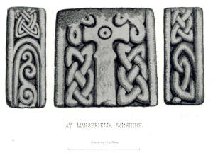
The wonderful illustration of the Mansfield Cross shown below appears
in J.Stuart's marvellous book 'Sculptured Stones of Scotland' (1867). The date of this publication presumably dates the discovery of the cross to 'some years before 1867'. Earlier in that century Sir Charles Stuart-Menteth of Closeburn, Dumfriesshire had purchased the Mansfield estate, and lived at Mansfield House. This elegant Victorian mansion was situated midway between the town of New Cumnock and Corsencon Hill on the Mansfield Road.
From here Sir Charles would oversee many of his mineral developments within the parish, including coal reserves at Grieve hill, less than 2 miles to the north, close to the parish boundary with Old Cumnock. According to [Carvel] 'one of the seams at Grieve was buried under nothing more than two or three foot of moss which was easily moved' . Could this moss have hidden the secret of the Mansfield Cross for more than a millennium ?
A return visit by the OS in 1955, shortly before Mansfield House was demolished, failed to throw any further light on the whereabouts of the cross or where exactly it was discovered.
Description
J Romilly Allen and Joseph Anderson in 'The Early Christian Monuments of Scotland (1903)' provide a detailed classification of the crosses of Scotland, including the Mansfield Cross, of which they remark,The sculptured stone was found some years ago in a moss near Mansfield House, in the parish of New Cumnock. It is a portion of an upright cross-slab of sandstone, 1 foot 5 inches high by 1 foot 5 inches wide by 7 inches thick, sculptured in relief on three face thus -
Front - (In the middle) a cross of shape No 106A with a dot and circle in the centre of the head; and on the background (to the left and right of the shaft) a four-cord plait.
Right side - (At the top) a four-cord plait; and (below) knot No. 214.
Left-side - Divided into two panels containing (1) at the top a four-cord plait, double-beaded, and (2) at the bottom scrolls of foliage.
Parabolic hollows in the cross-shaft and the foliage or vine scrolls are typical of Northumbrian or Anglian crosses. The Mansfield Cross was described as being 'much weathered' when it was discovered in the 19th century. Closer examination of the cross-shaft suggests the presence of some regular relief. In particular the two 'arrow-head' like symbols in the centre, which resemble the Anglian runes for the letter T. Does the Mansfield Cross contain some inscription for prayers for some lost soul? It should of course be remembered that image of the Mansfield Cross is an illustration and not a photograph of the actual fragment.
Origins
'W.G.Collingwood in his 'The Early Crosses of Galloway' shows the type of small cross set between interlace on the Mansfield fragment, although mainly on flat slabs which he considers to be Anglian, and the scrolling pattern on the edge could be derived from Northumbrian vine-scroll. the cross could have been 9th century, although a later date is possible'
[RCAHMS Private Correspondence]
Place-name evidence for early Northumbrian or Anglian settlement in New Cumnock is found at nearby Corsencon Hill, less than 2 miles to the east of Mansfield House. An earlier form of the name is Corswintoun which combines the later [Gaelic] element cor 'rounded-hill' with the [Old English] element swin-tun 'pig-farm'*. It is uncertain when these Anglian settlers arrived on the slopes of Corsencon hill, but it was probably after the British sub-kingdom of Kyle was annexed (presumably from the kingdom of Strathclyde) by Eadberht, king of Northumbria in 752. Although if the lands of New Cumnock once formed part of the kingdom of Rheged**, it may well have been under Northumbrian rule, if not an Anglian settlement a century beforehand.
Purpose
Consider now this analysis in the context of the Mansfield Cross -
Boundary: At the time of its erection in the 9th century the Mansfield Cross would have marked the extent of the Northumbrian settlement / advance in Nithsdale. Corsencon hill stands on the boundary between the modern day regions of Strathclyde and Dumfries & Galloway and before that on the Ayrshire / Dumfriesshire boundary and before that between the Sheriffdoms of Ayr and Nithsdale; and before that Kyle and Rheged .
Christian site : The place-name Mansfield appears to suggest a possible Christian site. However, the name is relatively young and was fashioned in the 19th century when the new owner of the lands of Garrieve renamed them Mansfield in honour of his wife's family name. There is a strong connection with the lands of Garrieve or Garrif and the church . For example 'the ancestors of the Gemmels of Garrive, came from Rome, with a number of followers, at an early period of the Christian era' [J. Paterson ]. Hugh Crawford, New Cumnock's first minister appointed in 1653 was 'in lieu of a salary given the old feudal land of Garrive, ground that had belonged to the Catholic church before it was largely destroyed during the Reformation.' [G.Sanderson]. Two named wells, i.e. Blubber Well near Meikle Garclaugh and Gowkthorn Well on Corsencon Hill provide further evidence of possible Christian activity in this vicinity. It t was not uncommon to find sacred wells and preaching crosses side by side.
A. Truckell in suggests that Holywood, Dumfriesshire (or the Holy Grove) was the Anglian minster for lower Nithsdale whilst Closeburn with its impressive Northumbrian Cross served that purpose for mid-Nithsdale He goes on to consider the crosses at Glencairn, Durisdeer and Kirkconnel as evidence of smaller ministers. It is reasonable therefore to promote Mansfield or more accurately Garrif, close to the Anglian settlement of Corsencon as another small minster in what effectively is Upper Nithsdale.
These minsters may well have been established over some earlier Christian sites e.g. Closeburn, kil- Osburn 'church of St.Osburn' and Kirkconnel kirk- Connel 'church of St.Connel'). Glencairn 'glen of the cairn', suggests an ancient burial or border cairn, whilst Durisdeer dorus doire ' door at the oak copse, thicket' and Holywood or Holy Grove indicate the presence of an oak grove where the ancient Druids indulged in their pagan worships. Indeed the great stone circle at Holywood clearly marks this place as a special pagan site within Nithsdale. It was fairly typical of the new Christian church to establish itself on such pagan sites and through time the place-names would change to reflect the holiness or sanctity of the place. The great grove in lower Nithsdale became the holy wood and the great stone circle became the 'The Twelve Apostles of Holywood'.
The forms of Garif, Garrive look suspiciously similar to the name grove and compares favourably with [Old English] graefe, graf(a) 'grove, copse' (cf. the numerous place-names Grafton, 'copse-town') and [Gaelic] garadh 'copse' or garan 'thicket'. From Pont's maps of the 16th century through to Armstrong's map of the 18th century the farm of Garif is depicted alongside a substantial wood, a remnant perhaps of an ancient copse.Close to Gariff are the farms of Garclaugh (Garueclach, Garclach) which appears to be [Gaelic] garadh clach 'copse, thicket stone'. Could this have been an ancient standing stone that stood at the thicket.
CIENT CROSSES
NEW CUMNOCK
© Robert Guthrie

ANCIENT CROSSES
Mansfield


Allen and Anderson classify the crosses according to their geometrical shapes and a cross of the shape No 106A is described as 'Cross with Parabolic Hollow Angles (with Shaft)'. Listed along with Mansfield are Minigaff (Wigtonshire) and two of the Nithsdale crosses in Dumfriesshire at Glencairn and Thornhill. The fragment of the Glencairn Cross, now in the magnificent collection in Dumfries Museum, clearly shows the parabolic hollow angles.


* Dalswinton in lower Nithsdale, Dumfriesshire and Glenswinton in Kirkcudbrightshire also contain this element.
Near to Corsencon is the farm of Glenmucklach which is Gaelic gleann muclac 'glen of the pig-farm'.
**Hugh Lorimer in
'A Corner of Old Strathclyde' considers
the place-name Dalricket, a mill on the River Nith some four miles upstream from Corsencon hill, to be Dal-Rheged cd. Dunragit 'fort of Rheged in w
Wigtonshire
Site of Mansfield Cross

The Mansfield Cross
was erected in the
9th century to mark
the small minster for
the Anglian settlement that was established
on the slopes of Corsencon hill. In accordance
with the strategy of the new Christian church,
the cross was erected at a pagan site, in this
case a grove or
thicket, which may
have had a standing
stone at it's entrance.
