
Corsencon Hill
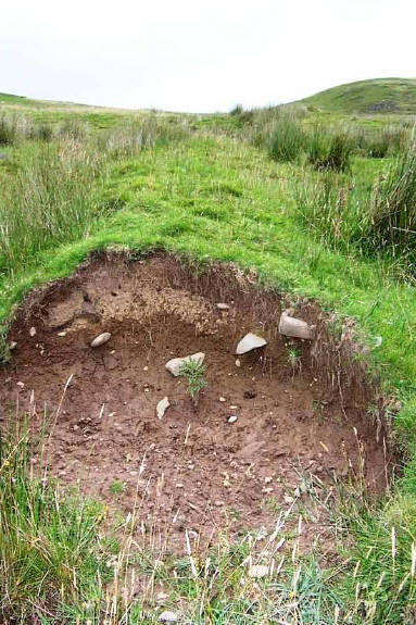
The course of the dyke can be readily picked up by following the modern-day drystane dyke that runs parallel with the Barscalloch Burn from the Corsencon - Little Garclaugh road (NS 665 138) up towards Corsencon Hill. As the drystane dyke ends the earthen dyke begins in the adjacent field (NS 665 142), across the the other side of the track to Hillend Knowe. This suggests that the drystane dyke may indeed have been built on the course of the original earthwork. An unnamed syke runs parallel with the dyke as it runs due north up the hillside. The dyke then curves rather dramatically and runs due east along the 300m contour possibly as far as the Ayrshire-Dumfriesshire boundary at the Rough Knowe (NS 673 143). As with the Deil's Dyke, part of this dyke has been damaged and the cross-section reveals some embedded stones, albeit smaller than their counterparts in the Deil's Dyke. Together, along with the River Nith, the Barscalloch Burn, the Ayrshire-Dumfriesshire boundary, the dyke appears to cut off a piece of land with Corsencon farm at its centre .
However this earthen dyke may in fact be part of the boat-shaped enclosure reported by F. Newall and W. Lonie in 'Discovery and Excavation', belonging to perhaps to a fermtoune. It is perhaps also no coincidence that Longhouse Burn, is found to the east of Corsencon farm, where longhouses have been known in Scotland since Viking times. The aforementioned Barscalloch Burn is probably the burn of the bald hill from Gaelic bar 'hill' sgallach 'bald', whilst Gaelic sgalag 'farm-servant' is worthy of consideration.
A. Graham and R.W. Feachem
A. Graham and R.W. Feachem considered other earthworks in their study of the Deil's Dyke in Dumfriesshire and Ayrshire and ultimately discounted them as part of the Deil's Dyke proper (DD in map above). Their assessments of such earthworks in the parish of New Cumnock are given below. Also included is the classification given to some of these earthworks by J. Barber, E. Lawes-Martay and J. Milln in 'The Linear Earthworks of Southern Scotland
survey and classification' (see Appendix).
The Afton Water, which flows northwards from its source on the western flank of Windy Standard to join the River Nith at New Cumnock, forms a decided interruption to the hills that border the right or southern side of Upper Nithsdale. The Deil's Dyke, as has been shown in Part II, runs almost continuously and without significant gaps for the sixteen miles from Burnmouth to Glen Afton, but W. of that point, although the Nith extends for a further nine or ten miles to its source between Prickeny and Enoch Hills, there is no further trace of an earthwork of similar character. Some old land-boundaries certainly occur in the area in question, which resemble the Dyke in dimensions and method of construction, but they differ from it in consisting of short isolated lengths, separated from one another by wide and unexplained gaps, and in not holding to the contour as does the Dyke for so much of its length. A critical comparison rapidly reveals the distinction between them and component parts of the Dyke, and no confusion ought to arise between the two classes of work.
The following notes on some of the more conspicuous examples are given by way of illustration.
Ashmark Hill
This is a length of ditchless earthen bank, running SW. for three-quarters of a mile from a sheepfold
170 yds. SSW. of the summit of Ashmark Hill along the ridge that rises to Lamb Hill. Here it comes to an end near the source of a narrow sike which runs down to the Connel Burn.
Knockburnie
Here a bank, similar to the last, starts at the head of a straight sike -which descends the north-eastern slope of Peat Hill to pass beneath the road from New Cumnock to Dalmellington near Knockburnie Cottage. The bank runs for a distance of 700 yds. over the brow of Peat Hill, and comes to an end at the head of a tributary of the Polmath Burn.
E Lawes-Martay Classification : Head-Dyke
Appears to cut off an area of 9km
2
defined by the River Nith , the Polmath Burn and the Lane Burn.
Maneight Hill and Meikle Hill
Appendix
The Linear Earthworks of Southern Scotland survey and classification
by John Barber with contributons from Elaine Lawes-Martay and Jeremy Milln
Classification of the Linear Earthworks of Southern Scotland in respect of the functions which could be attributed to them on economic-political continuum
Group 1: Political / administrative land divisions J.Barber
1.1 National border earthworks
1.2 Prehistoric and Early Medieval political boundaries
1.3 Parish, barony and other local administration
1.4 Cross-routeway linear earthworks
1.5 Anomalous features
Group 2: Economic land divisions - E Lawes-Martay
2.1 Enclosing large areas of land (> 5 km2)
2.2 Enclosing small areas of land (< 5km2)
2.3 Treb Dykes
2.4 Head-dykes
2.5 Agricultural boundaries
2.6 Park-pales and enclosures
2.7 Woodbanks
2.8 Miscellaneous land divisions
Group 3: Miscellaneous J. Barber
3.1 Defensive outworks
3.2 Modern
3.3 Anomalous; including sites incorrectly classified as earthworks
3.4 Destroyed
OTHER EARTHWORKS
The Dyke turning east with Corsencon Hill in the background
The Dyke running east marked by the line of rushes
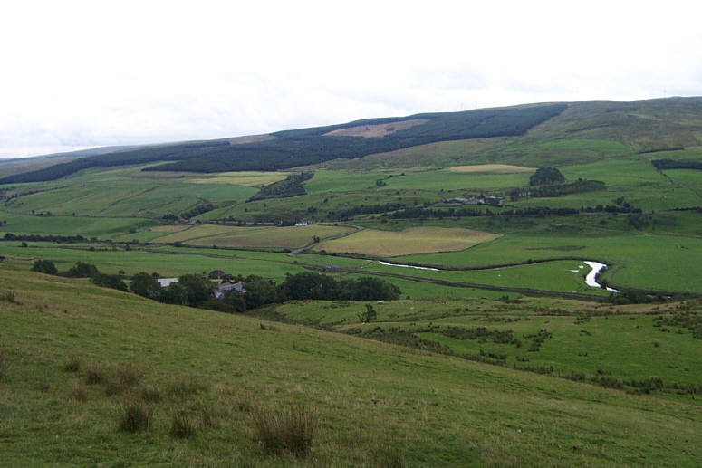
The land within the Dyke at Corsencon Farm with the loops of the River Nith in the distance and Overcairn Farm beyond
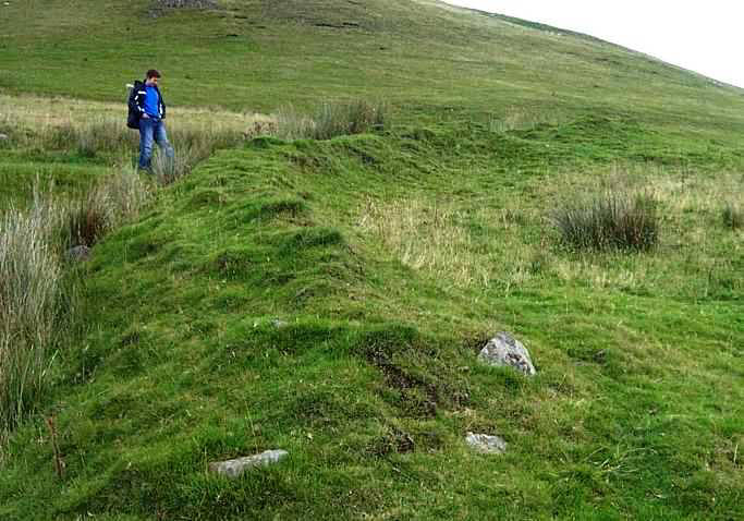
The Dyke running downhill(south) with unnamed syke running parallel, and Corsencon Hill behind
Cross Section of the Dyke showing small stones embedded below the turf
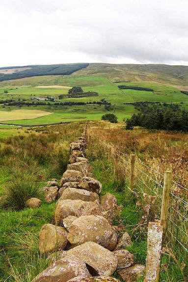
The modern-day drystane dyke running downhill with Overcairn Farm beyond

2
3
4
5
NEW CUMNOCK
© Robert Guthrie

Other Earthworks not considered as part of The Deil's Dyke
1. Corsencon Hill, 2. Ashmark Hill, 3. Knockburnie Hill, 4. Maneight Hill, 5. Meikle Hill
Other Earthworks