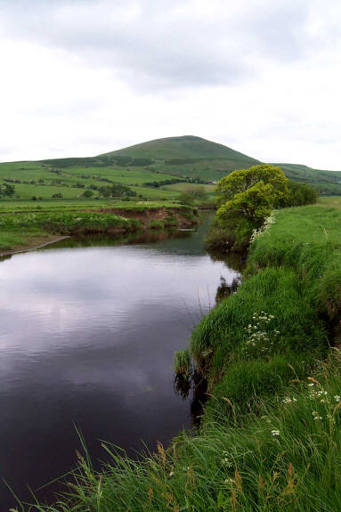
RIVER NITH AND NITHSDALE.
The River Irvine, the River Ayr and the River Doon all rise in Ayrshire and all flow to the Firth of Clyde. However, the noble Nith resists that temptation and alone amongst Ayrshire's major rivers it flows to the Solway Firth.
From the slopes of Enoch Hill in the parish of New Cumnock the Nith sets off in a northerly direction for a mile or so, passing the ruins of Waterhead Castle and then takes a sharp right and heads east, dividing the parish in two. Close to the site of the ancient seat of the Barons of Cumnock the Afton Water flows gently into the River Nith. A mile further downstream it begins to meander, attempting to prolong its stay in its native parish before reluctantly extending its farewell to New Cumnock and its life-long acquaintance Corsencon hill.
It enters Dumfriesshire at the parish of Kirkconnel and begins its journey through the district known as Nithsdale. On through the ancient Royal Burgh of Sanquhar, and past the 'dark castle' of the Crichtons. A few miles further downstream near the old church of Dalgarnock (which by no coincidence is dedicated to St.Enoch), the Nith is now heading due south, in the exact opposite direction to that which it left the slopes of Enoch Hill.
Dalswinton ('dale of the pig-farm) follows quickly reminding the Nith of home and its old friend Corsencon hill (Corswinton - 'rounded hill of the pig-farm') both place-names illustrative of how early 7 th century Anglian farmers used the natural route of Nithsdale to venture forth into new lands. Of course it was not one-way traffic, the farm of Ellisland is soon encountered, one time home of Robert Burns, where Rabbie would venture up and down the Nith valley moving his family from Mauchline, Ayrshire, thankfully taking time to pen his magical 'O were I on Parnassus hill'.
The county town of Dumfries beckons and the Nith makes a spectacular entrance. Appearing from under the ancient arches of Devorgilla's bridge she explodes on to the Whitesands and occasionally burst her banks here in a show of defiance. The estuary is ten miles distant and the Nith finally enters the Solway Firth, close to the glorious ruins of Caerlaverock Castle, one time seat of the Earls of Nithsdale.
The modern-day parish of New Cumnock may not be in the district of Nithsdale (in the same way that the former parish of Cumnock was not in the ancient sheriffdom of Niddis-dail) but nevertheless justly claims the birthright of the River Nith. Ptolemy called it the Novius, from which the ancient British tribe Novantae took their name; it is fitting that the Novius 'new, fresh' starts its life in New Cumnock.
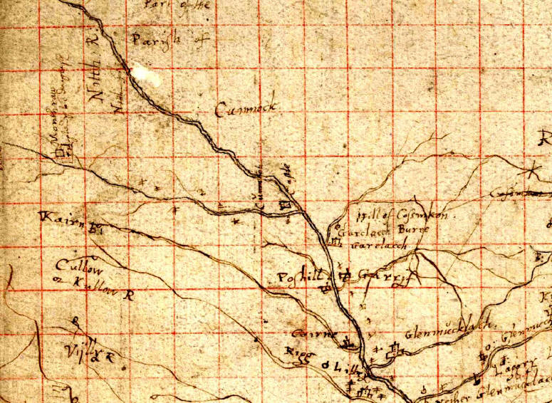
Pont Manuscript 35 'Nithsdale; part of Teviotdale'
'Nithsdale is the only extensive area in south Scotland which is depicted on a surviving Pont manuscript map and is one of the best of the collection' [ Stone].
Thankfully Timothy Pont did not let political boundaries unduly influence his work. The Pont Manuscript 35 'Nithsdale; part of Teviotdale' as the name suggests not only covers Nithsdale and part of the neighbouring Teviotdale as well, but it actually contains a little bit more. Tucked away in the north-west corner of the manuscript is the legend 'Part of Kyle'. There is of course limited detail pertaining to New Cumnock since Pont would have reserved for his 'Kyle Manuscript'. Sadly this is no longer extant and therefore the 'Part of Kyle' that appears in the Nithsdale Manuscript is a unique precious record of New Cumnock in Pont's own hand.
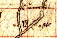
Cumnock Castle
It is impossible to say if Pont's image depicts a castle falling into ruins or a castle in the process of being renovated. But what can be conceded is that Timothy Pont in his Nithsdale Manuscript has left the only meaningful image we have of the ancient castle of the comunn ach.
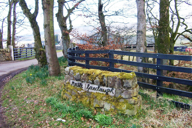
Garclaugh , Garrieve and Polshill
Pont, depicts the property of Garclacch as a fine two-storey building at the confluence of Garcclach Burne with the River Nith which corresponds to the location of the modern-farm of Little Garclaugh. However, his positioning of the now lost Garrif*, downstream (east) from Garclacch does not fit with the understanding of where this substantial property once stood. This error as to be expected is repeated in Blaeu's engraving of Nithia.
In Blaeu's Coila, based on Pont's map of Kyle the two properties of O.Garif and N.Gariff are properly located to the west (upstream) of the two properties of O.Garueclach and N. Garclach. The abbreviations O and N refer to Over and Nether respectively a common appellation for ferme-tounes at that time. Through the years Over Garueclach has become Meikle Garclaugh whilst Nether Garclach evolved into Little Garclaugh.
Across the River Nith is the farm of Polshill.
Corsencon Hill
Corsencon hill, may not be the highest hill in New Cumnock but it is surely one of the most impressive. Those who understand his symbols and know the location of the hill can only appreciate Pont's depiction of the Hill of Cofsinkon in his Nithsdale manuscript. The collection of single lines below Garclacch is Pont's three-dimensional view of the hill and it matches perfectly the conical form of Corsencon.
Blaeu has interpreted these single lines as a burn with three tributaries and as a consequence Corsencon hill does not appear in his map of Nithia. Apparently It is not uncommon to confuse Pont's single line depictions of hills for rivers or even coastlines. [Guide to Symbols on Pont's Manuscript Maps -NLS]. However, all the river courses shown in the section of Nithsdale are depicted by Pont with double-lines and there is no doubt that the single lines are Corsencon Hill.
The property of Glenmucklach is in the neighbouring parish of Kirkconnel, in upper Nithsdale.
Monthraw
On the northeast section of the manuscript, near the Spangock fl (Spango Water), the phrase 'head of (part of ) Douglaph is clearly written (Close by the name Robert is also recorded). This part of Kyle does march with Douglas Water. The last word of the descriptive phrase under the name Monthraw does indeed resemble the name Douglaph. However, there is of course no march with Douglas at the head of Glen Afton but rather as previously explained the boundaries are with Dumfriesshire and Kirkcudbrightshire.
Perhaps it is a reference to the surname Douglas rather than the placename? Could the text read 'Belonging to J Douglaph', i.e. a reference possibly to the owner of Monthraw? It is worth noting that the Water of Deugh , forms a march burn between Ayrshire and Kirkcudbrightshire and perhaps the locational note at Monthraw is a reference to this water, in the form Deugh fl.
Blaeu Map : NITHIA Viceomitatvs The Shirifdome of Nidis-Dail
'Fifty-six entries were omitted in the course of preparing the copper printing plate, a few because they were different to read or looked overcrowded' [ Stone}
Johan Blaeu began to print his Atlus Novus in Holland in 1654 some 40 years or so after Pont's death (ca. 1611). It is only to be expected that some errors would be made in transcription of vast amounts of place-names that perhaps were difficult to read let alone be unfamiliar to the engraver. The small part of Kyle that appears in Pont's Manuscript is reproduced in Blaeu's Nithia. However, it is not immune to omissions, errors or misinterpretations alluded to by Stone.
The legend 'Part of parish of Cumnock' has been omitted, the farm of Kraigshiel appears as the plausible Kraigshead and Pont's depiction of the hill of Cor f inkon has been misinterpreted as a small river with a number of tributaries.
Of course the most striking difference between the original Pont Manuscript and the Blaeu Map is the physical appearance. Gone are the intimate representations of Pont to be replaced by the standardised and sanitised symbols of the engraver. The unique depiction of Cumnock Castle is replaced by Blaeu's standard symbol for a castle or large dwelling that appear in abundance throughout Nithia. The Blaeu's Maps are marvellous in their own right but they lack that Pont roughness that Blaeu recognised because 'in the beginning all things are imperfect '.
Place-Names of New Cumnock: Pont vs. Blaeu
PONT & BLAEU
NEW CUMNOCK
© Robert Guthrie
Nithsdale
Pont Manuscript 35 'Nithsdale;
part of Teviotdale'
Reproduced by kind permission of the
Trustees of the National Library of Scotland
Pont Manuscript 35 'Nithsdale;
part of Teviotdale'
Reproduced by kind permission of the
Trustees of the National Library of Scotland
Pont Manuscript 35 'Nithsdale;
part of Teviotdale'
Reproduced by kind permission of the
Trustees of the National Library of Scotland

Pont Manuscript 35 'Nithsdale;
part of Teviotdale'
Reproduced by kind permission of the
Trustees of the National Library of Scotland


Pont Manuscript 35 'Nithsdale; part of Teviotdale'
Reproduced by kind permission of the Trustees of the National Library of Scotland
River Nith and
Corsencon Hill
Monthraw
*The lands of Garrieve were purhased by Sir James Stirling in 1790 and re-named Mansfield in honour of his wifr's family name.
|
PONT: NITHSDALE |
BLAEU: NITHIA |
BLAEU: COILA |
Ordnance Survey |
|
|
|
|
|
|
Places |
|
|
|
|
Cumnach Caftle |
Cummck Caflte |
Kumnock Caft |
|
|
Monthraw |
Monthraw |
Monwhra |
Monthraw |
|
Garclacch |
Garclacch |
N.Garclach O. Garueclach |
Garcluegh |
|
Garrif |
Garrif |
N. Gariff O. Garif |
Gariff (Grieve) |
|
Pofhill |
Pofhill |
N. Poufhil |
Polshill |
|
Kraigfhiel |
Kraigshead |
Kraigfheel |
Craigshiel |
|
|
|
|
|
|
Rivers |
|
|
|
|
Nitth R : |
Nith R. |
Nith Rio |
River Nith
|
|
Nith fl. |
|
Nith fl. |
|
|
A--toon
fl. |
Achtoun flu. |
|
|
|
Kairn b. |
Kairn b. |
|
Cairn |
|
Garclacch Burne |
Garclacch burne |
Garueclach b. |
Garcleugh burn |
|
|
|
|
|
|
Hills |
|
|
|
|
------------ |
Mebkorg Hill |
The lorg
hill |
Blacklorg Hill |
|
Hill of Cofsinkon |
Omitted |
KoBinkon hill |
|
|
|
|
|
|
|
Legends |
|
|
|
|
Part of Kyle |
PART OF KYLE |
|
Kyle |
|
Part of Parifh of Cumnock |
|
|
Parish of New Cumnock |
|
|
|
|
|
|
Robert |
|
|
|
