Place-names
PONT & BLAEU
NEW CUMNOCK
© Robert Guthrie

Place-names
|
Pont names |
|
Modern-day |
Grid |
Meaning |
|
AchincorB b. |
G6 |
Auchincross burn |
|
|
|
Litil AchincorB |
G5 |
Auchincross |
57 13 |
Field of the cross over the ridge |
|
Midle AchincorB |
G5 |
Hall of Auchincross |
58 14 |
|
|
Achinghy |
G4 |
Auchingee |
57 12 |
Field of the goose |
|
|
G1 |
|
63 08 |
Water, river |
|
Kraig of barachoun |
H2 |
McCowan's Knowe |
56 05 |
Hill of the son of Owen |
|
N. Benftoun |
G6 |
Benston House |
58 16 |
Woman's� town,farm |
|
O. Benftoun |
G6 |
Benston |
58 15 |
|
|
Hil of Bentykouba |
G3 |
Benty Cowan hill |
57 08 |
Hill of the house of Owen |
|
N. Bioch |
J5 |
Beoch |
|
Birch place, wood |
|
O. Byoch |
K5 |
|
52 10 |
|
|
Bootfoot |
F3 |
Boltcraig 'The Bowt' |
62 07 |
Bolt, border |
|
Black l. |
F6 |
Black loch |
59 15 |
Black , dark loch |
|
N. Blackwood |
E5 |
Blackwood |
64 13 |
Black , dark wood |
|
O. Blackwood |
D5 |
Blackwood |
64 13 |
|
|
Blakwood b. |
D3 |
Blackwood burn |
64 13 |
|
|
Blaireyin |
F4 |
Blarene |
58 09 |
Plain of the birds |
|
Blaireyin Hill |
G3 |
Blarene Hill |
58 09 |
|
|
Blareyn b. |
G2 |
Blarene burn |
59 09 |
|
|
Blakfarding b. |
H4 |
Blackfarding burn |
|
|
|
Blakfwrdingh |
H4 |
Blackfarding |
56 12 |
Black, dark farthing-land |
|
Blakkraig b. |
E2 |
Blackcraig burn |
|
|
|
Blakkraig hil |
E1 |
Blackcraig hill |
|
Black, dark rock, hill |
|
N. Blakkraig |
F3 |
Blackcraig |
63 08 |
|
|
O. Blakcraig |
F2 |
Blackcraig |
63 08 |
|
|
N. Boigcurroch |
F5 |
|
60 13 |
Bog, marsh |
|
O. Boigcurroch |
F4 |
|
60 12 |
|
|
Bouhous |
D4 |
|
|
Bower house, byre |
|
Bouhous |
E6 |
Bowes Cottage |
63 14 |
|
|
Brahead |
G4 |
Braehed |
57 13 |
Head of slope |
|
Brokloc |
F4 |
Brockloch |
59 10 |
Badger fold |
|
Brunftoun |
H5 |
Burnston |
54 12 |
Hill of Owen's town |
|
Brunftoun b. |
J5 |
Burnston burn |
54 12 |
|
|
Bryds b. |
C3 |
|
66 11 |
Bridget's burn |
|
Brydsbanck |
F4 |
The Bank |
61 12 |
St. Bridget's bank |
|
Byrs |
D5 |
|
|
Byre ? |
|
Chayng hil |
H3 |
Chang hill |
56 08 |
|
|
Chnip hill |
D3 |
The Knipes |
65 11 |
Hill |
|
Chorg |
H3 |
|
|
|
|
Chyrip Hil |
D4 |
The Knipes ? |
65 11 |
|
|
Clockluy |
D7 |
Clocklowie |
69 17 |
Stone of (Lowie ?) |
|
|
H5 |
Coalburn |
56 13 |
Back burn |
|
Criock |
G6 |
Cruck |
|
Boundary |
|
Culcrioc |
F4 |
Coalcreoch |
60 11 |
Back boundary |
|
Pont names |
|
Modern-day |
Grid |
Meaning |
|
Dalgig |
G5 |
Dalgig |
55 12 |
Land of the stone-wall, ditch |
|
Dalgig b. |
H5 |
Dalgig burn |
55 13 |
|
|
Dalhanna b. |
E2 |
Dalhanna burn |
62 10 |
|
|
N. Dalhanna |
E4 |
Little Dalhanna |
61 10 |
Land of the patron-saint's church |
|
O. Dalhanna |
E4 |
Over Dalhanna |
61 10 |
|
|
Dalbeglifh |
G4 |
Dalleagles |
57 10 |
Land of the church |
|
Dalheglifh b. |
H3 |
Dalleagles burn |
57 10 |
|
|
Dalney |
H4 |
? |
|
|
|
Drumkalladyr |
K4 |
|
|
|
|
The ridge of Drumkalladyr |
J4 |
Drumbrush rig ? |
54 06 |
The ridge of hard-water |
|
Efhmarck |
F4 |
Ashmark |
61 10 |
Ash merk-land |
|
Fairding |
G5 |
Farden |
58 11 |
Farthing-land |
|
Fairdingrioch |
G5 |
Fardenreoch |
56 13 |
Brindled farthing-land |
|
Gaitcleugh b. |
D3 |
Gatelochside burn |
64 12 |
Gate , ravine |
|
Gaithead |
E6 |
Gatehead |
62 14 |
Path , head |
|
N. Garclach |
D6 |
Meikle Garclaugh |
64 14 |
Stone enclosure, fort |
|
Garrif b. |
E6 |
|
|
|
|
N. Garrif |
E6 |
Garrieve Roughside
? |
62 15 |
Enclosure , hill �fort Grave?,� Sheriff�s
enclosure |
|
O. Garrif |
E6 |
|
|
|
|
Garueclach b. |
D7 |
Garclaugh burn |
65 14 |
|
|
O. Garueclach |
D6 |
Little Garclaugh |
65 14 |
|
|
Geuyich fl. |
H2 |
Water of Deugh ? |
58 05 |
|
|
Hal |
D5 |
|
|
|
|
Hilhead |
D4 |
Hillhead |
63 12 |
|
|
Karkur b. |
H2 |
Carcow burn |
60 08 |
|
|
Karkurn |
F3 |
Carcow |
60 08 |
Fort, place of the hazels |
|
O. Keyirns |
C5 |
Over Cairn |
67 13 |
Cairn, heap of stones |
|
N. Keyirs |
C5 |
Nether Cairn |
66 13 |
|
|
Scheles of Knocburny |
H3 |
|
|
|
|
Knokburny |
H3 |
Knockburnie |
56 10 |
�Hill of the stream |
|
Knokburny b. |
H3 |
Knockburnie burn |
55 08 |
|
|
Knokfinlok |
F4 |
Knockshinnoch |
60 12 |
Hill of the fox |
|
Konnyr b. |
F3 |
Connel Burn |
60 11 |
Fury, |
|
KoBinkon hil |
D6 |
Corsencon hill |
67 14 |
Round hill of the pig-farm |
|
O. KorBinkon |
C6 |
Over Corsencon |
66 13 |
|
|
N. KorBinkon |
D6 |
Nether Corsencon |
66 13 |
|
|
Korsgellok hil |
J5 |
Carsgailoch hill |
54 14 |
Cross of the nun, Cailleach |
|
Kraigbrinach |
F2 |
Craigbraneoch |
|
|
|
Kraigbyrnoth hil |
F1 |
Craigbraneoch Rig |
63 05 |
Rock of the place of the raven |
|
Kraig Darroch |
G2 |
Craigdarroch |
63 06 |
Rock of the oak |
|
Kraigfheel |
D6 |
Craigshiel |
67 15 |
Rock of the shieling, hut |
|
Kraigfhel b. |
C6 |
Craigshiel burn |
|
|
|
Kraigman |
J5 |
Craigman |
54 12 |
Rock of the mine, mineral |
|
N. Krioch |
G5 |
Meikle Creoch |
60 13 |
Boundary |
|
O. Krioch |
F6 |
Little Creoch |
59 14 |
|
|
Kumnock Caft |
F5 |
(New Cumnock) |
61 13 |
Place of the confluence |
|
Pont names |
|
Modern-day |
Grid |
Meaning |
|
Lachenguroch b. |
F2 |
Lochingirroch burn |
61 07 |
|
|
Ladringerah |
F3 |
Lochingirroch |
62 09 |
Stone of the enclosure |
|
N. Laglaf |
F3 |
Laglaff |
60 10 |
Noisy hollow |
|
O. Laglaf |
F3 |
Laglaff |
|
|
|
Laicht |
F4 |
Laight |
61 11 |
Grave-stone |
|
Lein b. |
H4 |
Lane burn |
57 12 |
Lane, slow winding burn |
|
Leinhead |
H4 |
Lanehead |
55 10 |
Head of lane, burn |
|
Leinmark |
G4 |
Lanemark |
58 11 |
Lane merk-land |
|
Lin b. |
K4 |
Linn Water |
52 07 |
Waterfall |
|
Litthen |
C7 |
Lethans |
69 15 |
|
|
Litthen b. |
C7 |
Lethans burn |
|
|
|
Litthen hil |
C7 |
Lethans hill |
69 15 |
Broad slope |
|
Littilmarck |
G3 |
Littlemark |
57 10 |
Little merk-land |
|
Lochbranen |
E3 |
Lochbrowan |
62 09 |
Stone of the hill of Owen |
|
The Lorg Hill |
E1 |
Greenlorg hill Blacklorg hill |
65 04 65 04 |
Slope |
|
Lowis |
F6 |
Lowes |
59 16 |
|
|
L. of the Lowis |
F6 |
|
60 14 |
|
|
N. Lowis |
F7 |
Mid Lowes |
60 16 |
|
|
O. Lowis |
F6 |
Lowesmuir |
60 16 |
|
|
Mains |
D6 |
( |
64 14 |
|
|
Makalaftoun |
E5 |
Makalaxastone |
(62 14) |
Makalaxa's town |
|
March b. |
C4 |
March burn |
67 12 |
March, boundary |
|
Marfhalmorck |
H3 |
Marshallmark |
57 10 |
|
|
Meekilhil |
K4 |
Meiklehill |
53 08 |
|
|
Mekil hil |
K3 |
Meikle hill |
53 07 |
Large hill |
|
Mil |
G5 |
Dalricket Mill |
57 13 |
|
|
Mill |
F5 |
Mossmark of Oldmill |
61 13 |
Moss merk-land |
|
Mofhoufe |
E6 |
(Mosshouse) |
(63 15) |
House on the moss |
|
Momescaple |
G6 |
Moss Caple |
(57 14) |
Horse moss |
|
Monachthil |
H3 |
Maneight hill |
54 08 |
|
|
Monaicht |
J4 |
Maneight |
54 09 |
Monk |
|
Monwhra |
F1 |
Monthraw |
63 03 |
|
|
Monwhra hil |
G1 |
Monthraw hill |
|
Hill of the boundary wall |
|
Moorstoun |
F5 |
|
(61 14) |
Moor (mere ?) town |
|
Mosmark |
F5 |
Mossmark |
61 13 |
Moss merk-land |
|
Nith fl. |
B6 |
River Nith |
63 13 |
New, fresh |
|
Nith Rio. |
K4 |
Source of the Nith |
55 06 |
|
|
Pont names |
|
Modern-day |
Grid |
Meaning |
|
O. Parck |
E4 |
|
62 12 |
High field |
|
Park b. |
E4 |
Park burn |
|
|
|
N. Park |
F5 |
|
61 12 |
Low field |
|
Percloif |
F3 |
Pencloe |
61 09 |
Head of enclosure |
|
Polmatth b. |
J3 |
Polmath burn |
54 10 |
|
|
Polmoth |
J4 |
(Polmath) |
(54 10) |
Good burn |
|
N. PolwhouB |
F5 |
Polquheys |
62 15 |
|
|
Powhois |
F6 |
High Polqhheys |
62 16 |
|
|
Polwhyrtyr b. |
D3 |
Polquhirter burn |
63 12 |
Carter's burn |
|
N. Polwhyrtyr |
E5 |
|
63 13 |
|
|
O. Polwhyrtyr |
E5 |
|
63 13 |
|
|
Powhyrtir |
D4 |
High Polquhirter |
63 12 |
|
|
N. Poufhil |
D5 |
Polshill |
65 13 |
|
|
Poulfhell b. |
D3 |
Polshill burn |
65 12 |
Sheiling burn |
|
Pouloifh |
E3 |
(Pollach) |
(63 08) |
|
|
Pouloifh b. |
E2 |
Pollach burn |
|
|
|
Powhaip |
F6 |
Polquhap |
58 16 |
Frothy burn |
|
Ridgehead |
H6 |
Rigghead |
57 14 |
Head of rig, ridge |
|
Rigend |
J4 |
Little Rigend |
54 11 |
End of rig, ridge |
|
Roting |
F7 |
Rottenyard |
61 15 |
|
|
Scheels |
D4 |
|
|
Sheilings |
|
Straid |
G4 |
Straid |
57 10 |
Street |
|
Strayid b. |
H3 |
Straid burn |
57 09 |
|
|
Waterfid |
F5 |
Waterside |
61 14 |
Water side |
|
Waterhead Caft |
J4 |
|
54 11 |
Head of water |
|
Weftland |
D5 |
Meikle Westland |
65 13 |
waste-land, �e.g. warren and
waste |
|
Neth Weftland |
C5 |
Waistland |
65 13 |
|
|
Welhill |
G6 |
Wellhill |
58 14 |
Well hill |
|
Whyth |
H4 |
Whitehill |
57 11 |
White hill |
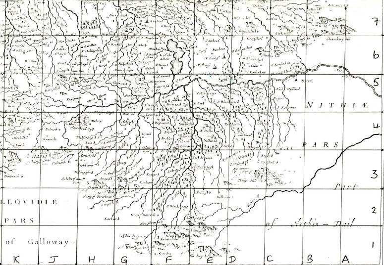
Parish of New Cumnock
Johan Blaeu 'Coila Provinicia',
Atlus Novus, 1654.
Reproduced by kind permission of theRoyal Scottish Geographical Society.