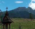
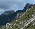
Giewont
(Kondratowa Dolina)
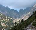
Hlupy Štít
(Javorová Dolina)
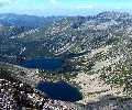
Velka Svistovka
(Dolina Zeleného Plesa)
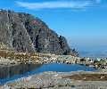
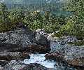
Téryho Chata
(Malá Studená Dolina)

Babia Góra
(Beskides)

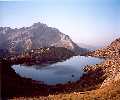
Trzy Korony
(Pieniny)

Sromowce Nizne
(Pieniny)

Spišská Magura
(Belianske Tatry)

Pilsko
(Beskides)

Wolowiec
(Chocholowska Dolina)

Bartne
(Beskides)

Magura Malastowska
(Beskides)
|
Les Hautes Tatras ("Vysoke Tatry") forment la partie haute, celle qui dépasse 2000m, des Tatras, partie supérieure de l'arc des Carpates, frontičre entre la Slovaquie et la Pologne. Grosso modo et vu du ciel le massif a la forme "feuille de fougčre", avec des vallées partant en épis, ŕ l'image des Pyrénées. Il en résulte une différence de climat entre les deux versants, d'oů grande variété de types de paysages. Au dessous la "capitale" Zakopane, la frontičre se situe exactement sur la ligne de partage des eaux (au Nord, toutes les eaux se jettent dans la Baltique, au Sud, dans le Danube). Plus ŕ l'Est et ŕ l'Ouest, le territoire Slovaque couvre un certain nombre de vallées du versant Nord. Chamois, marmottes, aigles, cerfs et quelques ours habient le massif. A premičre vue, on aurait tendance ŕ qualifier ce paysage d' "Alpin". Grossičre erreur ! Faune, flore, climat, traditions, gastronomie, autant de points les séparent que par exemple la Corse et les Alpes elles-męmes. Les Tatras sont situées ŕ la męme latitude que la Normandie, et bénéficient également d'un climat plus continental. Les Tatras sont de dimensions modestes (les plus hauts sommets dépassent 2600m), mais pour retrouver les męmes étages alpins, il y a un bon millier de mčtres ŕ retrancher aux Pyrénées, peut ętre un peu moins pour les Alpes. Le point faible des Tatras réside peut ętre dans leur faible superficie : surnommé "le plus petit haut massif d'Europe", cette jeune chaîne de montagnes s'étire sur 50km de long et 20 de large. Le double, si l'on y ajoute Beskides et Basses Tatras, leurs pendants respectifs au Nord et au Sud, davantage comparables au Massif Central. Cependant, si les Tatras se serrent les coudes, ce n'est que pour mieux compliquer leur dédale de vallées profondes ("Dolinas"), aiguiser encore plus leurs crętes, et offrir un concentré de beauté. Les glaciers, bien que de nos jours absents, ont laissé ici, plus que nulle part ailleurs, les traces des sévices qu'ils ont infligé ŕ ce château de granite. En témoignent les nombreux névés, qui restent longtemps. Et c'est avec encore plus d'humilité, ŕ l'issue de notre parcours, que je tire cette conclusion : qui veut prétendre "avoir fait le tour" des Tatras a encore plusieurs années devant lui. Cette petitesse toute relative a aussi un autre avantage : les points de départ des randonnées sont tous accessibles sans véhicule, grâce ŕ un excellent réseau de transports en commun (bus, trains, téléphériques), hérité en partie du socialisme. L'accessibilité des Tatras et son "exotisme" en font un massif d'aventuriers : il est possible de venir ici seul et de ne pas s'ennuyer. Dans ces pays lŕ, contrairement ŕ la France, la montagne n'est pas entachée par l'individualisme ancré dans notre société de consommation. Et le "Tatrisme", puisqu'ils ont inventé ce mot, est sujet ŕ un magnifique engouement chez tous les âges, y compris parmi les jeunes. |
The High Tatras ("Vysoke Tatry") form the high part of the Tatra mountains, over 2000m, northern part of the Carpathian Arc, and border between Slovakia and Poland. As seen from the sky, the massif has a "fern leave" shape, valleys speading sideways, at the image of the Pyrenees. It results in a strong climatic difference between both sides, then a wide variety in types of landscapes. Under the "capital" Zakopane, the border follows exactly the main ridge (from the Northern slopes, waters flow into the Baltic sea, on the Southern ones into Danube). Further East and West, Slovak territory covers a certain number of Northern valleys. Chamois, marmots, eagles, dears and even few bears live in the massif. At first sight, we could qualify it as an "Alpine" landscape. Big mistake ! Fauna, flora, climate, traditions, gastronomy, as many points separate them than for example Corsica and Alps themselves. Tatras are located at the same latitude than Cornwall, and also bear a more continental climat. Tatras have modest dimensions (the highest summits reach 2600m, 8500ft), but to find the same mountain levels, there is a good thousand meters to substract to Pyrénées, maybe a little less to the Alps. The weak point of Tatras might be their superficy : surnamed "the smallest high massif in Europe", this young mountain range spreads over 50km long and 20km large. The double, if we add Beskides and Low Tatras, their respective northern and southern counterparts, more likely comparable to the Massif Central. Anyay, if the Tatras are squeezing up, this is in order to complicate more their dedal of deep valleys ("Dolinas"), to sharp even more their ridges, and to offer a more dense beauty. Glaciers, despite being absents nowadays, left here more than anywhere else the prints of the treatment they inflicted to this granitic castle. Numerous icy slices, remaining late in the summer, witness it. And it is with even more modesty, at the end of our trek, that I find this conclusion : who wants to pretend to "know" Tatras still has many years ahead. This relative "smallness" also have another advantage : starting points for walks are all accessible without a vehicle, thanks to an excellent network of public transports (bus, trains, cable cars), partly herited from socialism. The accessibility of Tatras and its "exotism" makes it a place for adventurers : it is possible to come here alone and never get bored. In these countries, contrary to Western Europe, mountaineering is not wasted by the individualism of our "customer culture". And "Tatrism", since they invented this word, is subjet to a wonderful fashion for every age, including young people, and especially students. |
| 2005. Le charme a agi, les circonstances de la vie ont certes aussi beaucoup contribué... J'habite et je travaille en Pologne. Les Tatras, mais aussi tous ses massifs de moyenne montagne périphériques (Beskides, Pieniny, Gorce, sans oublier aussi les Sudčtes), sont ŕ portée de main, oů je veux et quand je veux. La rubrique est élargie au sens plus général des Carpates, et le carnet de courses est plus que jamais ouvert... | 2005. The charm worked, circumstances of life contributed certainly too... Now I live and I work in Poland. Tatras, but also all its neighbouring low mountain ranges (Beskides, Pieniny, Gorce, without also forgetting the Sudetes), is within reach, where I and when I want. The topic is extended to the more general meaning of Carpathian mountains, and the hiking log is open more than ever... |
|
|
|

|
Le sens Est-Ouest m'a été dicté par le sens de certaines hautes brčches (Priecne Sedlo, Sedlo Prielom et Polsky Hreben), recommandées voire autorisées seulement dans ce sens lŕ. Marcher le soleil dans le dos est également plus confortable. Plusieurs options étaient retenues pour le découpage des étapes, en fonction de notre condition jour aprčs jour. Grosso modo, aprčs la premičre étape au Chata pri Zelemom Pleso, l'option rapide consistait ŕ substituer Zbojnícka Chata et Zamkovského Chata ŕ Téryho Chata, toujours en contournant Vichodndé Visoké. Aprčs, Sliezsky Dom, puis Chata Pod Rysmy et Schronensko Pieciu Stawow Polski devaient compléter, mais nous interrompirent ŕ Chata Popradsku). Cependant, je juge l'option rapide tout ŕ fait réalisable pour des personnes normalement entrainées, et je recommande ce découpage (dans l'hypothčse oů la météo n'a pas son mot ŕ dire !). Ces infos sont données ŕ titre indicatif et je ne saurais en aucun cas ętre tenu pour responsable de l'usage qui peut en ętre fait. |
The East-West direction was dicted to me by few high tarns (Priecne Sedlo, Sedlo Prielom and Polsky Hreben), recommended, or even compulsory only in this direction. Walking with the sun in our back is also more comfortable. Several options were kept for the cut of the stages, depending on our condition day after day. Basicly, after the first stage at Chata pri Zelemom Pleso, the rapid option consisted in swapping Zbojnícka Chata and Zamkovského Chata for Téryho Chata, still circumventing Vichodndé Visoké . After, Sliezsky Dom, then Chata Pod Rysmy and Schronensko Pieciu Stawow Polski should have completed it (but we had to stop at Chata Popradsku). Anyway, I consider now the rapid option as absolutely possible, for normally fit hikers, and I recommend this set of stages (in the case when weather doesn't trouble the plans !). These informations are given as simple indications, I cannot be responsible for the use that can be done with them. |
Ostrva
(Mengusovská Dolina)
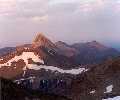
Kôprovský Štít
(Mengusovská Dolina)
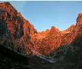
Ladové Pleso
(Zlomiskova Dolina)
Zakopane

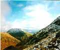
Turbacz
(Gorce)

Dunajec
(Pieniny)

Zdiar
(Belianske Tatry)

Široké Sedlo
(Belianske Tatry)

Starorobocianski Wierch
(Koscieliska Dolina)

Czerwony Wierch
(Koscieliska Dolina)

Wolowiec
(Beskides)

Bardejov
(Beskides)