((navigational Map: click on stars, mts., seas))

© Ukauga Region Plains of Turia - Home of the Wagon Peoples Polar Plains Torvaldsland Barren Lands RainForest Port Kassau Laura - River Port Ko-ro-ba Port Oini Lara Thentis Thentis Mts North Thassa Sea Panther Girls Oasis of the Tahari Hrimgar Mts. Northern Forest Helmutsport - Free Port Ti Vonda Lydius - Free Port Rarn Fort Haskins Kailiauk Ar's Station Tharna Teslit Holmesk Tabuk's Ford Harfax Besnit Esalinius Venna Port Kar Treve City of Ar Rarir Rorus Tabor Island Samnium Coreyrus Semris Kurtzal Tor Clearus Klima Dune Country:  Area located northwest of the Wastes and below the Teehra District. Lydia - Free Port Nyundo Port Schendi Falls of Bala Haruma Argentum Tarnwald Torcadino Minus Tarnburg Hochburg Port Kasra Turia Kargash Ta-Thassa Mts Anango Island Schendi Harbor:  The harbor is 8 pasangs wide, 2-3 pasangs deep, and opens onto the Nyoka River at the harbor's eastern end. The Nyoka flows from Lake Ushindi into Schendi Harbor, then into Thassa. Ianda Island Isle of Tyros Isle of Cos Priest Kings  - Nest - The colony and home of the Priest-Kings in the Sardar; the ruler of the Nest is the Mother from whose eggs the Priest-Kings are hatched. Priest-Kings of Gor, page 84 Port Brundisium Teletus Asperiche Hulneth Hunjer Skjern Scagnar Axe Glacier Pass of Tancred:  A pass through Hrimgar Mountains., northeast of Torvaldsland where the herds pass through. Parsit Current - The main eastward current of the waters above the polar basin, so named because of the several varieties of migrating parsit fish which follow it. Beasts of Gor, page 38 Iceberg Selnar Jad Telnus Temos Kasra Tentium Nyundo The Waists Torvaldsberg Pillar of Exchanges  South Thassa Sea Tahari Desert Voltai Mountains Lake Shaba Lake Ngao Lake Ushindi  Thassa Carius River:  It is a broad and swift flowing tributary of the Vosk. It drains the Ven highlands and has its own tributaries. The Thassa Cartius and the subequatorial Cartius are not the same river. Stream of Torvald -  A warm current, pasangs wide, it moves eastward to the coast of Torvaldsland and then north. It's warm temperature enables communication and re-supply of between the various small farms and communities of this bleak area. Those of Torvaldsland regard the stream as a gift of Thor, bestowed upon Torvald, legendary hero of the land, in exchange for a ring of gold. Marauders of Gor, pages 55-56 Woods of Clearchus Boswell Pass:  Pass through Mts. of Thentis to Barrens. Swamp Forest of Ar:  During the series we are alternately told that the Swamp Forest borders Ar to the north, and is located south of Ar. Fulvians Hills:  These are the foothills of the Voltai and are northeast of Ar. The villa district of Ar is found here. Ven Highlands:  Home of jungle tribes in Equatorial Rain Forests Canals of Bila Haruma:  Man-made canal from Lake Ushindi to Lake Ngao. Southern Prairies of Gor:  The prairies stretch from Thassa and Ta-Thassa Mountains to the southern foothills of the Voltai Range, bordered on the north by the Cartius River. Stones of Turmus Turmas Teehra District:  District on the northern most part of the Tahari just west of Tor. Guard of the Dunes Hills of Eteocles:  These are located southwest of Corcyrus, the springs in the hills feed aqueducts for Torcodino. Swamp Land: The lands south and central between lake Ushindi and Lake Ngao, thousands of pasangs in area. Polar Cap:  Far North Villages of Ukungo Villages of Ubartes SardarMts.  Skerry of Einar:  It is by the Rune-Stone of the Torvaldsmark and marks the boundary of the Torvaldsland and the south. Farnacium Rive-De-Bois:  Translated it means 'River of the Woods', no real located given in the books. TAMBER GULF... Where the Vosk river empties into Thassa.  ..of course, even among the eastern rence growers is that delta is claimed by Port Kar, which lies wihtin it, some hundred pasangs from its northwestern edge, bordering on the shallow Tamber gulf, beyond which is gleaming Thassa, the Sea. Tahari Salt Flats:  (The Salt Districts) Several districts of the Tahari Desert where salt is produced, widely separated in the midst of dune country located between the Wastes. Home of the Red Hunters Maelstrom located southwest of Tyros, in which the wreckage of ships occasionally appears.


Vosk River League Map Link

Vosk River Map


In 
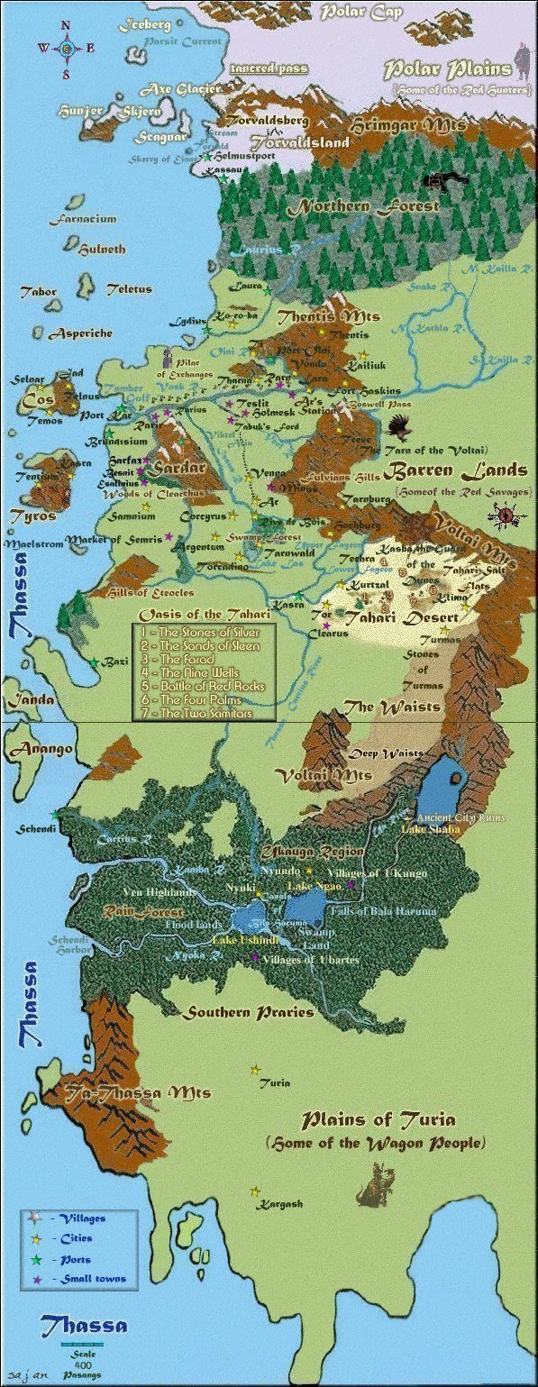
large outline Gor, as would be expected, was not a sphere, but a spheroid. It was somewhat heavier in its southern hemisphere and was shaped somewhat like the Earth - like a rounded, inverted top. The angle of its axis was somewhat sharper than the Earth's, but not enough to prevent its having a glorious periodicity of seasons.
Moreover, like the Earth, it had two polar regions and an equatorial belt, interspersed with northern and southern temperate zones. Much of the area of Gor, surprisingly enough, was blank on the map, but I was overwhelmed trying to commit as many of the rivers, seas, plains, and peninsulas to memory as I could.


chapter3 Gor1 **TARNSMAN OF GOR**


You need a Java-capable web browser to see the applet.

((click on txt to stop to read.. then click again to continue))


  Maps designed by "Sajana"

Any Use of the Pictures or Maps must only be used with express permission from Sajana...
If at any time the use is wished just email..
NO EXCEPTIONS!!


Any advice or suggestions or You wish to be added to a HomeStone,

contact sajana at:

Email


Friday, December 14, 2001 3:51 PM
*updated Sept. 16, 2005*