


The Nova Scotia Climber's Resource page is designed to provide information useful for
novice and advanced climbers alike. You will find maps to Nova Scotia climbing areas, and
photos that show what these areas have to offer. Throughout this site you will find links to
external pages where information on a given subject has already been compiled by other parties.
Nova Scotia has a high quality network of climbing Web sites and this site has been designed to
integrate into that network.
Special Feature:
Photos of Teth in 1995 at Clarence Cliff, Anapolis County
That's right, photos of me back in the day. These are photos of me climbing in Nova Scotia
five years before I had even heard of Climb Nova Scotia. You may also take note of the cliff, as it
is still there, on the North Mountain of the Anapolis Valley above Clarence. This ~45 foot pillow
basalt cliff is very inviting to the novice climber with about four quality 5.8 climbs. It is located on
the south facing face of an in-cut into the North mountain and with the sun beating down on the
black rock, and sheltered from the prevailing valley wind, this cliff has a micro climate which
makes for comfortable climbing even after all the leaves have fallen from the trees. When it is
raining in the valley below, it is often sunny at Clarence Cliff.

There is quite a stunning view of the Anapolis Valley from the top of Clarence Cliff. I am
the guy styling in the NIKE ball cap and black denim jacket.

Here is a photo of me showing off. Some things never change. Here you can also see the
top half of Clarence Cliff. This cliff has so many hand holds that you have to choose which ones
you want to use, like in the gym. I used to climb the same route five times in a row and never use
the same hold twice. The wall is vertical though and consistently in the 5.8 to 5.9 range depending
on which handholds you use.

Lunch time at the top of Clarence Cliff. That's me on the right. I had forgotten about that
mustache.

Our anchor setup involved a fixed line running twenty feet to an oak tree. We used a top
belay with the belayer clipped into a safety line. This setup once resulted in me taking a 15 foot
fall on top-rope because we used a new dynamic rope for the safety line and it was tied a little
longer than it should have been. Also, as a top-rope purest I always climbed with lots of slack in
the line anyway. The end result was my belayer being hulled off the top of the cliff and left
hanging upside down three feet from the top. My tippy toe touched ground at maximum rope
stretch before I bounced back. The fall was long enough for the following thoughts to run through
my mind: "Oh my god I am falling!"..."Oh, right, I am on a rope. No need to worry."... "Gee, I
have been falling an awfully long time!" The morals of this story are: use static rope or webbing
for safety lines, and if you have time to remember that you are on a rope, then something has gone
wrong.

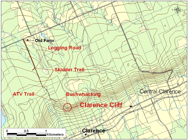
Here is where Clarence Cliff is located. To get to Clarence Cliff, take the 101 Highway to
the Lawrencetown exit. Head toward the North Mountain. Turn left at the T intersection. Turn
right at Central Clarence and head over the top of the North Mountain. Turn left at the T
intersection. Pass two roads on your right and as you come over the rise look for an old farm (the
last farm) on your left. Immediately after the farm is a logging road also on your left. Park on the
side of the road and walk in along the logging road (the area has been clear-cut). When the road
veers off to the right, look for a skidder trail going straight ahead. When the skidder trail becomes
an ATV trail (there should be some exposed bedrock here) take the branch of the ATV trail which
goes left. After a little distance you will see a cabin off a side trail on the left. Just after seeing the
cabin the trail goes downhill into a small clearing where you turn left. You should see the rusting
remains of a stove here. Some time later you enter a Y intersection through one of the branches.
Go straight and just over the rise where the trail veers right and starts winding down the North
Mountain, you veer left into the bush and follow the ridge line to the cliff. There should be some
pink marking tape to help guide you.
Page Sponsored By:

Page Design By:

Webmaster: tethc@yahoo.com
Last updated: March 13, 2004


