This is the story of Hurricane Katrina and the Mississippi Gulf Coast, including
some pictures of what happened to many boats along the Mississippi Gulf Coast.

The Story of Hurricane Katrina
and the Mississippi Gulf Coast
|| HOME | TEXT ONLY | TROPICAL STORMS WORLDWIDE | ATLANTIC TROPICAL REGION | EASTERN PACIFIC | CENTRAL PACIFIC |
|
WESTERN PACIFIC | INDIAN OCEAN | UNITED STATES SATELLITE IMAGES  | WORLDWIDE SATELLITE IMAGES AND WEATHER |

Department of Homeland Security Current Threat Condition
Risk of Terrorist Attacks
More Information
Department of Homeland Security

BLUE BACKGROUND INDICATES YOU VIEWING THIS POST 119 HURRICANE KATRINA PAGE

THE STORY OF HURRICANE KATRINA - TEXT

THE TRACK OF KATRINA & RADAR & SATELLITE

DESTRUCTION OF POST 119 BY KATRINA

THE GULFPORT VA CENTER AFTER KATRINA

RESIDENTIAL PICTURES PICTURES AFTER KATRINA

OTHER PICTURES ALONG THE GULF COAST

PICTURES OF BOATS FOLLOWING KATRINA

AERIAL PICTURES OF KATRINA'S DESTRUCTION

DIRECTORY OF HURRICANE KATRINA LINKS


Pictures Of Boats And Hurricane Katrina

Small Mirror Like Calm Lake

Cabin Cruiser In Graveyard

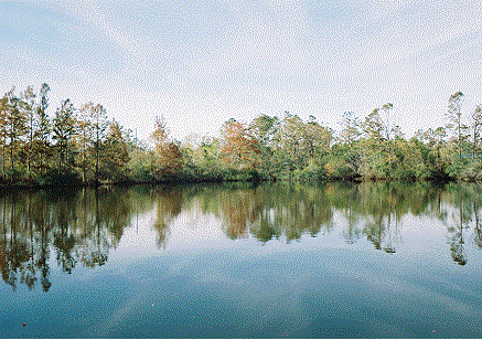
     The picture on the left is a beautiful quiet, calm mirror-like man-made small lake on the Mississippi Gulf Coast about 4 miles north of the Beach Boulevard. Notice how high the trees are in the background of the picture, with small gaps in the tree line. The gaps play a large part in what happened to the Cabin Cruiser in the next picture.
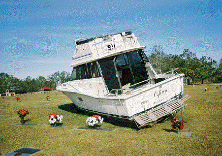
     The picture on the right shows what happened to the Cabin Cruiser when Katrina's Storm Surge lifted the boat up out of Bayou Bernard, up into this lake, and then up and through a gap in the tree line. What was, and still is behind that tree line? Floral Hills Memorial Gardens Cemetery. When the water slowly receeded, the Cabin Cruiser was gently docked on the grass, in the center of the Cemetery. Most of the Grave Markers in Floral Hills are flat markers, and the boat came to rest nearly on top of some of them. The boat remained there for several months, but has now been removed by the owner of the boat.

Boats Beached In The Industrial Seaway

Boats Tangled On The Dock

     The picture on the left show large vessels beached in a channel called the Industrial Seaway. This seaway provides passage to Gulfport Lake where it ends. Many larger boats seek safe mooring both in the Industrial Seaway and in Gulfport Lake. Along the Industrial Seaway, the boats are usually tied to large trees at the bow and anchored under the water at the stern. The 30+ foot Storm Surge of Hurricane Katrina beached or sunk many small and larger boats who's owners thought that after Katrina had passed they would be able to return their boats to their normal moorings.
     If the boats in the picture on the right had not been securely tied to their docks, they would have wound up inland as far as the 30+ foot Storm Surge would take them, or smashed into the riverfront home in the background.

Gulfpost Coast Guard Small Boats

Gulfport Coast Guard Large Boats

     Above are pictures of United States Coast Guard - 8th Coast Guard District - Station Gulfport When it became obvious to the Coast Guard Station that Katrina would create an extremely high Storm Surge they left their docks for safe mooring further eastward toward Mobile. Immediately after Hurricane Katrina moved inland, they returned at "Full Steam" to the Mississippi Gulf Coast and performed "Search and Rescue Missions". Search and Rescue...SAR...on water is usually the jurisdiction of the United States Coast Guard, but inland waters may also fall under the authority of State or Local Government agencies. Afterwards, there is often a Critique Phase where each phase of the operation is analyzed to determine what could have been done better, or why things worked as well as they did. The Coast Guard's motto in Latin is Semper Paratus, meaning Always Prepared or Always Ready. Their motto certainly applied both before and after Hurricane Katrina, and still continues today. By the way, the Coast Guard Station Gulfport main building, located near the lower end of the dock in the right had picture, was destroyed by Hurricane Katrina. Plans to rebuild are underway.


BLUE BACKGROUND INDICATES YOU VIEWING THIS POST 119 HURRICANE KATRINA PAGE

THE STORY OF HURRICANE KATRINA - TEXT

THE TRACK OF KATRINA & RADAR & SATELLITE

DESTRUCTION OF POST 119 BY KATRINA

THE GULFPORT VA CENTER AFTER KATRINA

RESIDENTIAL PICTURES PICTURES AFTER KATRINA

OTHER PICTURES ALONG THE GULF COAST

PICTURES OF BOATS FOLLOWING KATRINA

AERIAL PICTURES OF KATRINA'S DESTRUCTION

DIRECTORY OF HURRICANE KATRINA LINKS


Please Choose Another Link Above To Continue The Story

Disclaimer

This site contains links to other Internet sites. These links are not endorsements of any products
or services on such sites, and no information in such site has been endorsed or approved by this site.

| SITE MAP | LEGION INTERNET DIRECTORIES | POST LOCATION DIRECTORIES | TROPICAL STORMS WORLDWIDE |
HOME
CREATED AND MAINTAINED BY AMERICAN LEGION POST 119 GULFPORT MISSISSIPPI AS
A SERVICE TO THE AMERICAN LEGION COMMUNITY AND ALL VETERANS ORGANIZATIONS
EMAIL