|
|
|
|
4 November Beryl and I went out to have a look at a possible walk for the Ramblers. Actually the original plan had been to walk slightly further west - more around the Stiperstones - but that would have started in one of the two Shropshire parishes that still have substantial footpath closures. We parked at Bridges instead (having had a stimulating drive across the op of the Long Mynd from Church Stretton). The Mynd itself was quite late in opening; judging from the signs and temporary fencing on the top, this was because it is home to hefted sheep. This are specially adapted to local conditions and therefore would easily be replaced if they were lost. So they have fenced them off for extra protection. The morning was really sunny and I got some good photos as we followed the Shropshire Way along Darnford Brook and then climbed up through Golden Valley on to the ridge. This is a lovely path (as indeed most of the Shropshire Way is when it is west of Shrewsbury) and a real joy to walk even though it had some distinctly damp patches. We left the Shropshire Way when we reached the ridge; whilst the Way does take in part of the Long Mynd this is well to the south of the high point. We were on another long distance path, the Portway, which I think is an old drovers' road. The first section is called the Betchcott Hills and we stopped for a drink near the trig station (413m). It is an easy walk from there to Pole Bank, the high point of the Mynd at 516m. It gets quite busy when you get to the two roads across the top, as there is lots of car parking and easy walking with good views. The scene is dominated by the Stiperstones and Corndon Hill to the west - Corndon being just in Wales - and the two Clees and the Wrekin to the east. We could see as far as the Malverns, or at least they were the furthest hills that I could recognise (very distinctive shape). It was very windy on top and it had a cold edge to it. WE both wrapped up and I had my fleece hat on for the first time in months. Beryl looked very windswept when she posed for the mandatory photo by the viewfinder on Pole Bank. We didn't stay on the ridge for look after starting the descent at Pole Cottage. After a while we turned off the main path down into Stanbatch Valley. We were out of the wind again and the sun reappeared: it looked very pretty. Shortly after we picked up the Shropshire Way again. This included a fair sretch on lanes to provide a gradual climb up the side of Adstone Hill and a path along the ridge first to the high point (369m) and then right back into Bridges. Whilst this was an easy section it was not without incident. First we saw three buzzards riding the wind. Then I went over on my ankle and I seem to have crocked it pretty badly. Tem miles covered. The walk certainly is a possible for the Ramblers although I still think it would be better to go over to the Stiperstones. An outing
to the Lakes with the gang from work. First time in ages that I'd been with them
(various reasons for that which I needn't go into here) but it was a super day
out. Made all the better for the fact that, for the first time in ages, I didn't
have to drive and I didn't have to do the map reading. Apart from the two
led-walks in Austria I can't remember the last time I didn't have to do either. I suppose
that you could say that the weather wasn't brilliant but there was a time at
which we would have bought it for the day if we'd had the offer. This time was
round about when we passed Preston on the motorway as it was pouring down and
visibility was very poor. The rain stopped before we got to Ambleside, which was
the parking place, (I'd forgotten how expensive parking can be in the Lakes) but
the cloud base was still very low. We had no expectation of seeing much. Our route
took us up the eastern side of the Fairfield Horseshoe. Why there? Well I have
frequently referred to the group as poor benighted Wainwright-baggers (and there
is only one cure for this condition which is to finish the lot) and Barry and
Maxine still had Low Pike and High Pike to do. That might also have applied to
Dennis (who is the least systematic about his list); he claims to have crossed
them off but is uncertain about why he has done so. When I
came up here before (a traverse from Ambleside to Patterdale with the Ramblers
which took in Fairfield and St Sunday Crag) we ascended via High Sweden Bridge.
Ian who was leading went via Low Sweden Bridge. He was amazed when I said I'd
not been this way but not as amazed as I was when he said, much later in the
day, that he hadn't been to High Sweden Bridge, which is much the more
attractive spot. The
ascent was very gradual and full of mist and autumn colours, the two
complementing each other brilliantly. The cloud at this stage was patchy and we
were getting some visibility and photo-opportunities. It was also clear that it
was lifting on the lower fells but hanging around in the valleys; in effect
there were two cloud levels and we were emerging between them. We were also
thankful for the recent cold snap: the ground was still frozen and this made the
boggy bits less boggy. Low Pike
isn't much more than a pimple on the ridge but it does have a lovely little
craggy top which is the source of its interest. Apparently Wainwright says that
there is only room for one person there; we proved him wrong but there wasn't
room for all six of us. We did stop to take in the view. The mist was clinging
to one side of the ridge ahead whilst the other side was clear (most of the
time); Little Hart Crag at the head of Scandale
kept appearing and disappearing and it looked positively sunny over in the
Langdales. High Pike
looked very impressive on the ridge but was less so on arrival. A grassy mound.
The was one lump of rock and this provided a sheltered spot for an early lunch
stop. This was also make-your-mind-up time as the walk plan went no further than
"Reach High Pike". At this stage it was developed to "Proceed to
Dove Crag" which we did without difficulty. As we were now in rather more
solid cloud we also checked out the departure points to cross to the head of
Scandale as this was the probable option for continuing. This was
my fifth time on Dove Crag which makes it my most visited Wainwright (it had
been joint leader with High Street before) It was also an extra Wainwright for
Barry and Maxine. Again this is an unimpressive top and those who only do the
Fairfield Horseshoe get no indication of the massive crag from which it is
named. The best way to see that is to walk up Dovedale from Brotherswater and
then take the path up the side of the crag (assuming you are not a rock climber)
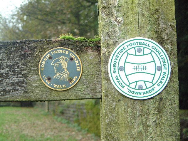
We did get to see it as we descended to the head of Scandale. The mist had cleared again at this point and we got the best views of the day, especially from the top of Little Hart Crag (new Wainwright No 4 for Barry). I was snapping away around there. I have this theory that the best views are often from little hills surrounded by bigger ones - oh Lord, I'll be raving about Haystacks next, just like Wainwright!! This was the wimping out point. We could have gone on to Red Screes but instead we opted for the path down Scandale. None of us had done it before so it did have its interest. I thought it would be a bit boggy but apart from a couple of stream crossings it was good path all the way back. It also had the advantage of taking us past High Sweden Bridge which was a good spot to stop and reflect upon the day (and for Dennis to play silly devils in the beck) A good day rounded off with a polartec-and-goretex experience in Ambleside and a pint in the Watermill. Beryl and I went on the Ramblers walk which started at Osmaston near Ashbourne. I'd like o say that I knew a lot about where we walked but I wasn't taking that much notice. Even having studied the map I'm not clear about it. We went through Osmaston Park, which was quite attractive, and then through Shirley to Hollington, crossing some mucky ploughed fields. We hen went to Rodsley but I haven't got a clue about the route. There was then a fair section on the road heading to Wyaston but we returned to the fields at Wyastoncommon farm before returning via Wyaston Grove on what was probably the best section of path on the walk. I was very surprise about the angle on which we reached Osmaston. I spent most of the day nettering to people. Not many pictures but one interesting waymark. It referred to the Downards and the Shrove Tuesday football. This is the big came in Ashbourne and the Downards are one of the teams. Why they have a walk, I don't know. The waymark was on the same post as one for Bonny Prince Charlie's walk; Derby was the limit of his march south in 1745.
Another pass out for a
Saturday (although probably the last this year!) I drove a long way to
have a relaxed and easy walk. This was to pick up my final Hewitt on the Snowdon
range, Yr Aran. It is a Marilyn
too. I parked at Rhyd Ddu and set off on the path to Snowdon summit. This rises
nice and gradually with views of Moel Eilio, Mynydd Mawr, the Nantlle Ridge, the
Hebog ridge and Llyn Cwellin. The path split after about a mile and the branch
to Yr Aran continues to climb gradually. After a while you reach
abandoned slate workings and then ridge the lesser Snowdon Horseshoe. This is
formed by the Watkin Path on the far side of the valley and the Clogwyn Du ridge
on this. Walkers arrive at this point from both the Watkin and Rhyd Ddu sides
but most turn to go up Snowdon. The opposite turn goes to Yr Aran and an interesting
climb it is. It is sharp enough in places to take the breath away. There is one
section of bog to circumnavigate. You also have to get your hands out of your
pockets and scramble a little. There is one lovely section on the ascend where
the path levels out (for which relief, much thanks) and the path contours around
the outside of the climb with a glorious view over to Lliwedd, Moel Siabod and
the Moelwyns. The top is a superb viewpoint. It is wonderfully remote from the other tops and had a better view, Snowdon summit being under cloud. There were two guys there when I arrived. They told me that they were doing the Welsh Nuttalls so we had a chat about peak bagging and took photos of each other (having swapped cameras for the purpose) An easy stroll back down then A quiet morning walk with the Ramblers on Cannock Chase. Here are a couple of photos to show that Autumn has come to the Chase
25 November An
unpleasant day for walking. We went
on the SRG day walk around Stone. Beryl had been in two minds over whether she
wanted to go as the forecast was more and she'd not been well for several days
before. If she had decided not to, I would have gone off to do a prewalk for the
new club programme. But we
went. And it was muddy. And it poured down. And it was generally depressing. In fact
Beryl was so disenchanted that we decided to leave the walk and come back along
the road - I'd promised her that we could do this before she finally decided to
walk. We told the leader what we planned and everyone else decided that they'd
had enough and came back with us. And for once I didn't take any photographs!
|
|