 What's New! Detailed Sitemap All images © by Roberto Piperno, owner of the domain. Write to romapip@quipo.it. Text edited by Rosamie Moore. Page added in November 2013. |
 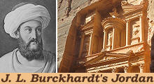 - Ajlun Castle and Pella - Ajlun Castle and Pella(left: J. L. Burckhardt in Arab attire in a XIXth century engraving; right: the Treasury of Petra) If you came to this page directly, you might wish to read a page with an introduction to this section first. May 3rd, 1812 - We set out early in the morning, and descended the valley towards Adjeloun (Ajlun), which has given its name to the district: it is built in a narrow passage on both sides of the rivulet of Djenne, and contains nothing remarkable except a fine ancient mosque. I left my horse here, and took a man of the village to accompany me to the castle of Rabbad, which stands on the top of a mountain three quarters of an hour distant from Adjeloun. J. L. Burckhardt - Travels in Syria and the Holy Land - 1822
It is the residence of the chief of the district of Adjeloun. The house of Barekat, in whom this authority has for many years resided, had lately been quarrelling about it among themselves; the chief, Youssef el Barekat, had been besieged for several months in the castle; he was now gone to the Aga of Tabaria (Governor of Tiberias), to engage him in his interests; and his family were left in the castle with strict orders not to let any unknown persons enter it, and to keep the gate secured. I had letters of recommendation to Youssef from the Mutsellim (officer in charge of the civil administration) of Damascus; when I arrived at the castle-gate, all the inhabitants assembled upon the wall, to enquire who I was, and what I wanted. I explained to them the nature of my visit, and shewed them the Mutsellims letter, upon which they opened the iron gate, but continued to entertain great suspicions of me until a man who could read having been sent for, my letter was read aloud; all the family then vied in civilities towards me, especially when I told them that I intended to proceed to Tabaria.
Kalaat Er-Rabbad is very strong, and, as appears from several Arabic inscriptions, was built by Sultan Szelah-eddyn; its date is, therefore, that of the Crusades, and the same as that of many castles in other parts of Syria, which owe their origin to the vigilance, and prudence of that monarch. Salah ad-Din, known in Europe as Saladin, of Syrian/Kurdish origin became Sultan of Egypt in 1171 and in 1175 he conquered Syria. Initially he followed a policy of coexistence with the Kingdom of Jerusalem and the other Crusader States.
Rabbad is two hours distant from the Ghor, or valley of the river Jordan, over which, as well as the neighbouring mountains, it commands a fine prospect. The castle was built in 1184-85 by a nephew of Saladin in order to control the moves of the Crusaders in the River Jordan valley and to protect the route between Syria and Egypt.
I saw nothing particularly worth notice in it; its thick walls, arched passages, and small bastions, are common to all the castles of the middle ages. It was probably from this castle that in 1187 Saladin moved with his army to lay siege to Tiberias. He acted in response to the plundering of a Muslim caravan by Raynauld of Chatillon, Lord of Kerak, a castle south of Ajlun. The Crusader army sent to the rescue of Tiberias was defeated near that town and Saladin conquered Jerusalem. You may wish to see a section on the Crusader Castles in the Levant or visit Nimrod Castle, north of Tiberias which was built by the heirs of Saladin.
Pella Burckhardt left Ajlun and moved northwards to Om Keis (Umm Qays), in the northern part of the River Jordan valley to see the ruins of Gadara, an ancient Roman town. He was not aware that by taking a detour he could have seen those of Pella, another ancient town, which, similar to Gadara, was part of Decapolis, a loose federation of towns to which the Romans granted some degree of self-government. The ruins of Pella were first visited in March 1818 by Charles Irby and James Mangles, two British commanders in the Royal Navy.
On his way to Om Keis Burckhardt met with some merchants who were in their way to the Ghor, to purchase new barley, of which grain the harvest had already begun in the hot climate of that valley. (..) We had now entered the valley of the Ghor. (..) It is one of the lowest levels in Syria (200m/700ft below sea level); its temperature is hotter than I had experienced in any other part of Syria: the rocky mountains concentrating the heat, and preventing the air from being cooled by the westerly winds in summer. In consequence of this higher degree of heat, the productions of the Ghor ripen long before those of the Haouran. The early farmers of the Ghor built their towns on the hills in order to escape the hot climate of the valley in addition to usual defensive reasons.
First major excavations started in 1966, but because of the 1967 war and ensuing political tensions they could be resumed only in 1979. Australian archaeologists found out that the hill had been inhabited since prehistory and they uncovered a Canaanite temple dated circa 1650 BC. When the first British travellers visited Pella the site was unpopulated, but in the 1960s Jordan authorities had to evict the inhabitants of a small village to allow archaeological research. The name Pella was given to the settlement after the conquest of the region by Alexander the Great in 332 BC, Pella being the capital of his Macedonian kingdom.
Archaeologists will eventually discover other remains of the ancient town, but in 2013 it was still difficult to realize the layout of ancient Pella. The Roman centre of the town was most likely in a small valley crossed by a spring which granted a continuous supply of water because there is evidence of baths and of a fountain. The centre included an odeon (a small theatre) and other buildings, such as tribunals, the columns of which were used for the construction of a very large church.
The Middle Church is so named because it is located between two other churches: the Eastern Church at the site where the spring originated and the Western Church on the other side of the hill of Pella. The Middle Church has the shape of a basilica with three naves, the central one being very large.
The Middle Church was built with materials which were part of IInd century AD buildings. "Cipollino", a green marble from Greece, was made very popular by Emperor Hadrian when he decorated the Library of Athens using this stone rather than white marble. All the towns of the Empire decided they wanted to embellish their monuments with some "cipollino" columns.
A third large church stood at the western foot of the hill, at the entrance to the town from the valley. Unlike the Middle Church, columns from previous buildings were utilized only for a portico in front of the church. Pella was conquered by the Muslim Arabs in 635, one year before the whole of the region, including Syria, fell to the invaders. The decline of Pella was rapid because there is no evidence of the churches being turned into mosques. A major earthquake struck Pella in 747 or 749; it was probably the last blow to the prosperity of the town. The image used as background for this page shows a detail of a capital at the Middle Church. Move to: Introductory Page Amman and its environs (July 7th, 1812) Aqaba "Castles" in the Desert (incl. Qasr el-Azraq) Jerash (May 2nd, 1812) Madaba (July 13th, 1812) Mt. Nebo and the Dead Sea (July 14th, 1812) On the Road to Petra (incl. Kerak and Showbak) (July 14th - August 19th, 1812) Petra (August 22nd, 1812) Umm al-Jimal Umm Qays (May 5th, 1812)    
|


