
Russia |
|
|
|
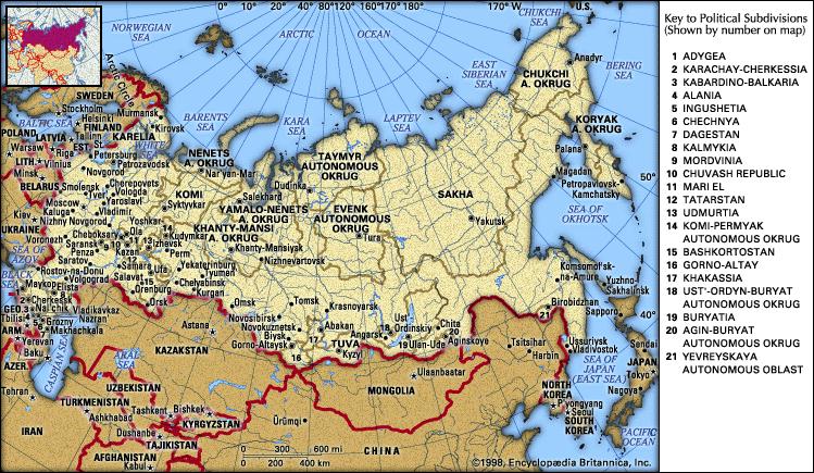
Russia The USSR had a totalitarian political system in which Communist Party leaders held political and economic power. The state owned all companies and land, and the government controlled production of goods and other aspects of the economy, a system known as a command, or planned, economy. After the collapse of the Soviet Union, Russia began transforming itself into a more democratic society with an economy based on market mechanisms and principles. Russia has made many successful changes: There have been free elections at all levels of government; private ownership of property has been legalized; and large segments of the economy are now privately owned. The transformation is far from complete, however. In the economic sphere, privatized assets have not been allocated fairly among the population and privatization of land is still in its infancy. Russia must also deal with the large-scale environmental destruction and other problems inherited from the Soviet Union. In the political arena, a stable society based on citizen involvement in local, regional, and national affairs has yet to develop. The transformation has affected the people of Russia in a variety of ways. Under the Soviet system, Russians became accustomed to having the government define many aspects of their lives. For many, the collapse of the USSR and the Communist ideal created an ideological void, and Russians have increasingly turned to traditional and nontraditional faiths to fill that void. The post-Soviet era has also seen an overall decline in Russia’s population, despite the influx of immigrants from other parts of the former Soviet Union. Russia has the lowest life expectancy and the highest infant mortality rate of the industrialized countries. In addition, the incidence of several infectious diseases has increased markedly in recent years. The social welfare system, already constrained by inadequate funding, is greatly challenged to combat these growing problems. In general, Russia’s climate is similar to that of Canada. Much of the land lies north of the 50th parallel of latitude and far from the moderating influences of oceans. Like Canada, though colder and with greater temperature extremes in many places, most of Russia has a harsh continental climate. Although climate, and to some degree soils, limit the country’s agricultural wealth, mineral wealth is considerable: Russia’s mineral resources are unmatched by any other country. Russia’s borders measure more than 20,100 km (12,500 mi). On the north Russia is bounded by extensions of the Arctic Ocean: the Barents, Kara, Laptev, East Siberian, and Chukchi seas. On the east the country is bounded by the Pacific Ocean and several of its extensions: the Bering Strait (which separates Russia from Alaska), the Bering Sea, the Sea of Okhotsk, and the Sea of Japan (East Sea). In the extreme southeast Russia abuts the northeastern tip of North Korea. On the south it is bounded by China, Mongolia, Kazakhstan, Azerbaijan, Georgia, and the Black Sea. On the southwest it is bounded by Ukraine, and on the west by Belarus, Latvia, Estonia, the Gulf of Finland, and Finland. In the extreme northwest, Russia is bounded by Norway. Lithuania and Poland border Kaliningrad Oblast, a Russian exclave on the Baltic Sea. Administratively, Russia includes 21 republics; 6 territories known as krays; 10 national areas called okrugs; 49 districts, or oblasts; 1 autonomous region; and 2 cities with federal status. The capital and largest city is Moscow. In both total area and geographic extent Russia is the largest country in the world. With an area of 17,075,200 sq km (6,592,770 sq mi), Russia constitutes more than one-ninth of the world’s land area and nearly twice the area of the United States or China. From north to south Russia extends more than 4000 km (2400 mi) from Arctic islands in the Barents Sea to the southern border along the Caucasus Mountains. From the eastern coast of the Baltic Sea to Big Diomede Island (Ratmanov Island) in the Bering Strait, Russia’s maximum east-west extent is almost 10,000 km (6200 mi), a distance encompassing 11 time zones and spanning nearly half the circumference of the earth. Russia also stretches across parts of two continents, Europe and Asia, with the Ural Mountains and Ural River marking the boundary between them. Russia’s principal islands lie in the Arctic and Pacific oceans and their extensions. Farthest north, in the Arctic Ocean, is Franz Josef Land, an archipelago consisting of about 100 small islands. The other main Arctic islands, from west to east, include the two islands of Novaya Zemlya, Vaygach Island, the group of islands called Severnaya Zemlya, the New Siberian Islands, and Wrangel Island. Between these major islands lie numerous small islands and island chains. In the Pacific Ocean are the Kuril Islands, which extend southwest in an arc from the Kamchatka Peninsula to the main islands of Japan. Russia occupies and administers all the Kuril Islands, although ownership of the four southernmost islands is disputed with Japan. The Pacific also includes the large island of Sakhalin, which separates the Seas of Okhotsk and Japan. Russia contains complex geologic structures and surface formations. Very simply, however, the landmass consists of vast plains in the west and north, and a discontinuous belt of mountains and plateaus on the south and east. The upland and mountainous regions include most of Siberia and extend to the Pacific. Russia can be divided into several broad geographic regions. From east to west they are the Great European Plain; the Ural Mountains; the mountain systems and ranges along much of Russia’s southern border; and the lowlands and uplands of Siberia, including the West Siberian Plain, the Central Siberian Plateau, and the mountain ranges of northeastern Siberia. Most of European Russia is part of a rolling plain that arcs across the continent into Russia, where it widens and has an average elevation of about 200 m (about 600 ft). Over millions of years the actions of streams, winds, and glaciers have deposited nearly horizontal layers of sedimentary rocks onto the plain. In some places, these same actions have eroded the softer sedimentary rocks, leaving the hard igneous and metamorphic layers exposed at the surface. The topography is generally rough in these areas of outcropping. Some surface features owe their origins to glaciation. Among these features are several areas of glacial deposits, such as the Valday Hills, which lie between Moscow and Saint Petersburg. As the glaciers retreated during the last glacial age, which ended about 10,000 to 12,000 years ago, a series of semicircular hills formed at the terminus, or edge, of the glacier. This area, known as a terminal moraine, runs east from the border with Belarus, then north of Moscow to the Arctic coast. For the most part, however, the relief of the European Plain is only modest. Much of the northern part of European Russia is very flat and poorly drained, with many swamps and lakes. By contrast, the southern part of European Russia contains rich soils that support most of the region’s agriculture. The Great European Plain terminates in the east at the Ural Mountains, an old, worn-down series of mountain ranges with an average elevation of about 600 m (about 2000 ft). The highest elevation (1894 m/6214 ft) is Gora Narodnaya. Despite their modest heights, the Urals are important for a wide variety of mineral deposits, including mineral fuels, iron ore, nonferrous metals, and nonmetallic minerals. The Caucasus Mountains, located between the Black and Caspian seas, comprise two major folded mountain chains divided along their entire extent by lowlands. The northern Greater Caucasus (Bol’shoy Kavkaz) form part of Russia’s southwestern border with Georgia and Azerbaijan. Geologically complex, the mountain system is composed of granite and other crystalline rocks, with some volcanic formations. The Greater Caucasus reach a maximum elevation of 5642 m (18,510 ft) at El’brus, an extinct volcano that is the highest peak in Europe, as well as Russia’s highest point. Other mountain ranges extend along much of the southern border of central and eastern Siberia to the Pacific Ocean. Among them are the Altay, Sayan, Yablonovyy, and Stanovoy ranges, which merge with the far eastern mountain ranges. All the southern mountain ranges contain valuable mineral resources. Between the Urals and the Yenisey River lies the West Siberian Plain, vast lowlands that make up perhaps the largest area of level land in the world. At its widest, the region spans about 1800 km (about 1100 mi), and it stretches from the Arctic Ocean in the north to the steppes of Central Asia in the south. The lowlands are extremely flat and poorly drained, with many marshes, swamps, and peat bogs. The northern and central parts contain important oil and natural gas deposits. East of the Yenisey the land rises to form a rolling plateau that stretches to the Lena River. Elevations here average 500 to 700 m (1600 to 2300 ft). Throughout the region rivers have eroded the surface and in some places have formed deep canyons. The geologic structure of the plateau is complex; a basement of igneous and metamorphic rocks is topped in many places by thick sedimentary rocks and volcanic lava. The plateau is thought to contain significant deposits of black coal. East of the Lena River the topography consists of a series of mountains and basins. Peaks in the higher ranges, such as the Verkhoyansk, Cherskiy, and Kolyma, reach maximum elevations of about 2300 to 3200 m (about 7500 to 10,500 ft). Farther east the mountains are even higher and steeper, and volcanic activity is prevalent. On the Kamchatka Peninsula there are 120 volcanoes, including 23 that are active. The highest cone, Klyuchevskaya Sopka, reaches an elevation of 4750 m (15,584 ft). The mountains continue offshore to form the Kuril Islands, which contain about 100 volcanoes, including 30 that are active. Russia’s longest rivers are all located in Siberia. The Ob’ and Irtysh rivers form Russia’s largest river system, which is also the largest in Asia and the fourth largest in the world. Together, these rivers flow 5410 km (3362 mi) north from western China through western Siberia to the Arctic Ocean. Several tributaries of the Ob’, including the Irtysh, flow through neighboring Kazakhstan. The Amur and its headwaters, the Onon and the Shilka, form Russia’s second longest system, with a total length of 4416 km (2744 mi). The Onon flows northeast from Mongolia into southern Siberia, where it joins the Ingoda to form the Shilka, which continues in a northeasterly direction. At the border with China the Shilka joins the Argun to form the Amur, which continues along the border for about 1610 km (about 1000 mi) before heading north to the Pacific Ocean. Among individual rivers, the Lena River is longest; it flows 4400 km (2700 mi) north through Siberia to the Arctic Ocean from its source near Lake Baikal. The next longest individual rivers are the Irtysh and the Ob’. The Volga, located in European Russia, is the country’s fourth longest river and the longest river in Europe. Together with its two main tributaries, the Kama and Oka rivers, it drains a large eastern portion of the Great European Plain southeast to the Caspian Sea. The fifth longest river, the Yenisey, flows north from Mongolia through central Siberia to the Arctic Ocean. Its main tributary is the Angara River, which flows from Lake Baikal, Russia’s largest freshwater lake. The Yenisey River carries more water than any other stream system in the country. In size of flow, it is followed by the Lena, Ob’ Amur, and Volga rivers. All the other rivers have much smaller flows. Many other streams and rivers are significant because they serve as transportation routes or power sources in densely populated areas, or because their waters are used for irrigation. Notable among these is the Don River, which lies in the southern portion of European Russia and drains south to the Sea of Azov. On the northern portion of the Great European Plain, the Daugava (Western Dvina) and Narva rivers flow north and west to the Baltic Sea; the Pechora, Northern Dvina, Mezen’ and Onega rivers flow to the Barents Sea and the White Sea. The Terek and Kuban’ rivers originate in the Greater Caucasus and are important for irrigation purposes. The Terek descends steeply from the mountains before flowing east to the Caspian Sea, while the Kuban’ flows west to the Sea of Azov. During the Soviet period the government was active in building large dams for electrical power, irrigation, flood control, and navigational purposes. On some rivers a series of huge reservoirs have transformed the drainage basins. The most extensive construction has taken place on the Volga-Kama system and the Don River on the Great European Plain, and on the upper portions of the Yenisey-Angara system and Ob’-Irtysh system in Siberia. A series of dams on the Volga has significantly slowed the river and decreased the volume of water it can carry. The decline in the flow of the Kuban’ and Don rivers has been even greater. As a result, the rivers retain even more of the pollutants that are discharged into their waters, and the spawning grounds of sturgeon and other fish have been greatly reduced. Many of the dams do not have properly functioning fish ladders, and as a result many fish do not make it past the dams to their spawning grounds. Inadequate or nonexistent wastewater treatment also contributes to the degradation of rivers and lakes. Many natural lakes occur in Russia, particularly in the glaciated northwestern portion of the country. The Caspian Sea on Russia’s southern border is the world’s largest lake in terms of surface area. Although called a sea, it is actually a saline lake that occupies a land depression. Rivers drain into the Caspian, but the deep basin does not fill with water and overflow to the sea. Water escapes only through evaporation; over a period of time the salts that are left behind accumulate in the water, making the lake saline. Lake Baikal in southern Siberia has the largest surface area of any lake entirely within Russia, and it is the largest in the world in terms of volume; it is estimated to contain one-fifth of the earth’s fresh surface water. With a maximum depth of 1637 m (5371 ft), Lake Baikal is also the world’s deepest freshwater lake. Russia’s next two largest lakes in terms of surface area are Lake Ladoga and Lake Onega. Located in northwestern Russia, these freshwater lakes are the two largest lakes in Europe. Russia has the longest continuous coastline of any country in the world. Its coastline stretches 37,650 km (23,400 mi), mostly along the Arctic and Pacific oceans; other coasts lie along the Black Sea and the Caspian Sea in the south. Because the majority of its coast lies in waters that are frozen for many months of the year, Russia has few year-round oceanic outlets. Despite these limitations, Russian shipping and fishing takes place on all the seas. The broad zones of natural vegetation and soils correspond closely to the country’s climate zones. Summers are too cool for trees in the far north, where tundra vegetation of mosses, lichens, and low shrubs grows instead. Permafrost, or permanently frozen subsoil, is found throughout this region. The ground is frozen to great depths, and even in summer only a shallow surface layer thaws. There is a polar desert zone on several Arctic islands to the north of the tundra zone; the vegetation in this zone consists of a limited number of moss and lichen groupings scattered in patches. Russia’s forests, located mostly in Siberia, cover more than two-fifths of the country’s total territory, and account for nearly one-fourth of the world’s total forested area. The forest zone has two distinct areas: a large, mainly coniferous forest, or taiga, lies in the north, and a much smaller area of mixed forest lies in the south. The taiga occupies two-fifths of European Russia and extends across the Urals to cover much of Siberia. Much of the taiga also has permafrost. This vast zone is made up primarily of coniferous trees, but birch, poplar, aspen, willow, and other deciduous trees add to the diversity of the forest in some places. The taiga contains the world’s largest coniferous forest, representing about one-third of the earth’s softwood timber. In the extreme northwestern part of the European region, the taiga is dominated by a variety of pines, although significant numbers of fir, birch, and other trees are also present. Eastward to the western slopes of the Urals, pines are still common, but firs predominate. Some regions, however, have stands of trees that are made up almost exclusively of birch. The taiga of the West Siberian Plain consists primarily of various species of pine, but birch is dominant along the southern fringes of the forest. Larch, a deciduous conifer, becomes dominant throughout much of the Central Siberian Upland and the mountains of eastern Siberia. Throughout the taiga zone, trees are generally small and widely spaced. Large areas are devoid of trees, particularly where the soil is poorly drained. In these areas marsh grasses and bushes form the vegetative cover. The taiga contains infertile, acidic soils known as ultisols, or podzols. A mixed forest, containing both coniferous and broad-leaved deciduous trees, occupies the central portion of the Great European Plain between Saint Petersburg and the Ukrainian border. The mixed forest is dominated by coniferous evergreen trees in the north and broad-leaved trees in the south. The principal broad-leaved species are oak, beech, maple, and hornbeam. A similar forest of somewhat different species prevails along the middle Amur River valley and south along the Ussuri River valley. Gray-brown soils are found in the mixed forest zone. Less infertile than the soils of the taiga, these soils can be kept quite productive with proper farming methods and heavy fertilization. To the south, the mixed forest transitions through a narrow zone of forest-steppe and then passes into the zone of a true steppe. The natural vegetation of a forest-steppe is grassland with scattered groves of trees. However, much of Russia’s forest-steppe has been cleared of its original cover and is now under cultivation. The forest-steppe zone averages about 150 km (about 95 mi) wide and stretches east across the middle Volga Valley and southern Ural Mountains into the southern portions of the West Siberian Plain. Isolated areas of this zone can be found in the southern basins between the mountains of eastern Siberia. The natural vegetation of a true steppe consists of a mixture of grasses with only a few stunted trees in sheltered valleys. Like the forest-steppe, Russia’s steppe is now mostly under cultivation. It includes the area northwest of the Greater Caucasus Mountains and a strip of land that extends east across the southern Volga Valley, the southern Urals, and parts of western Siberia. Both the forest-steppe and the steppe have fertile soils and together form a region known as the chernozem, or black-earth, belt; this is the agricultural heartland of Russia. Soils in the chernozem belt are high in humus content and have a balance of minerals that is suitable for most crops. The forest-steppe has a better moisture supply than the steppe during the growing season, and consequently is the best agricultural area of Russia. The chestnut and brown soils of the southern steppe are not quite as rich in humus as the chernozems to the north, but are very high in mineral content and can be productive with adequate moisture. Animal life is
abundant and varied throughout many parts of Russia. The tundra, which spans the Arctic
and northern Pacific coasts and encompasses Russia’s offshore Arctic islands, is home
to polar bears, seals, walruses, polar foxes, lemmings, reindeer, and white hare. Bird
life includes white partridges, polar owls, gulls, and loons. Geese, swans, and ducks
migrate into the region during summer, when mosquitoes, gnats, and other insects also
emerge. South of the tundra, the taiga is a habitat for elks, brown bears, lynx, sables,
and a variety of forest birds, including owls and nightingales. Swamps in this zone have
been stocked with muskrats from Canada. Muskrats and squirrels are now the main source of
pelts trapped in the wild. The broad-leaved forests of the Central European and West
Siberian plains contain boars, deer, wolves, foxes, and minks. There are also a variety of
birds, snakes, lizards, and tortoises. The forests of far southeastern Russia are known
for their Siberian tigers—the largest cat in the world—as well as leopards,
bears, and deer. The steppe primarily contains rodents such as marmots and hamsters, but
there are also a number of hoofed animals, including steppe antelope. The main beasts of
prey are steppe polecats and Tatar foxes. Bird life includes cranes and eagles. The
Caucasus region is particularly abundant in wildlife, including mountain goats, chamois,
Caucasian deer, wild boars, porcupines, leopards, hyenas, jackals, squirrels, and bears.
There is also a variety of game fowl, including black grouses, turkey hens, and stone
partridges. Reptiles and amphibians are also numerous in the Caucasus region. Russia contains the greatest reserves of mineral resources of any country in the world. Although minerals are abundant, many are in remote areas with extreme climate conditions, which makes them expensive to extract. Russia is especially rich in mineral fuels. The country may hold as much as one-half of the world’s potential coal reserves and may hold larger reserves of petroleum than any other nation. Coal deposits are scattered widely throughout the country; by far the largest fields lie in central and eastern Siberia, but the most developed fields are in western Siberia, the northeastern European region, the area around Moscow, and the Urals. The major petroleum deposits are in western Siberia and the Volga-Urals region. Smaller deposits are found in many other parts of the country. The principal natural gas deposits, of which Russia holds about 40 percent of the world’s reserves, are along Siberia’s Arctic coast, in the northern Caucasus region, and in the northwestern Russia. The primary iron-ore deposits are found south of Moscow, near the Ukrainian border in an area known as the Kursk Magnetic Anomaly; in this area, vast deposits of iron ore have caused a deviation in the earth’s magnetic field. Smaller iron ore deposits are scattered throughout the country. The Urals contain minor deposits of manganese. Other important iron alloys—such as nickel, tungsten, cobalt, and molybdenum—occur in adequate or even abundant quantities. Russia is also well endowed with most of the nonferrous metals. The aluminum ores Russia does have are found primarily in the Urals, northwestern European Russia, and south central Siberia. Copper, on the other hand, is abundant: Reserves are found in the Urals, the Noril’sk area near the mouth of the Yenisey River in eastern Siberia, and the Kola Peninsula. A large deposit east of Lake Baikal became commercially exploitable when the Baikal-Amur Magistral (BAM) railroad was completed in 1989. Lead and zinc ores are abundant in the northern Caucasus, far eastern Russia, and the western edge of the Kuznetsk Basin in southern Siberia. These ores are commonly found with copper, gold, silver, and a variety of rare metals. Russia has some of the world’s largest gold reserves, primarily in Siberia and the Urals. There are mercury deposits in the far northeastern part of Russia. Large asbestos deposits exist in the central and southern Urals and in south central Siberia. Raw materials for the manufacture of chemicals are also abundant. These include potassium and magnesium salt deposits in the Kama River district of the western Urals. Some of the world’s largest deposits of apatite (a mineral from which phosphate is derived) are in the central Kola Peninsula; other types of phosphate ores are found in other parts of the country. Common rock salt is found in the southwestern Urals and southwest of Lake Baikal. Surface deposits of salt are derived from salt lakes along the lower Volga Valley. Sulfur is found in the Urals and the middle Volga Valley. High-grade limestone, used for the production of cement, is found in many parts of the country, but particularly near Belgorod near the border with Ukraine, and in the Zhiguli Hills area of the middle Volga Valley. Most of Russia has a harsh climate with long, cold winters and short, relatively cool summers. This is because Russia lies at high latitudes, and because high mountains along the country’s southern border block most maritime tropical air masses from penetrating into Russia. During winter the moderating influence of the frozen Arctic Ocean is slight. Because most of the territory lies in a zone of westerly weather patterns, warm influences from the Pacific Ocean in the east do not reach far inland. This is particularly true in winter, when a large, cold high-pressure cell, which is centered in Mongolia, spreads over much of Siberia. The primary marine influence comes from the Atlantic Ocean in the west, but by the time Atlantic air reaches Russia it has crossed the entire western part of Europe and undergone considerable modification. It penetrates the landmass most easily during summer, when a low-pressure system generally exists over the land. At that time warm, moist Atlantic air may push east well into central Siberia. This is the principal moisture-bearing air mass to reach Russia, and most of the territory consequently receives fairly high levels of summer precipitation. The summer precipitation is important for croplands, which need moisture during the growing season. In many areas, however, the distribution of rainfall during the summer is not advantageous. Drought often occurs in early summer, and middle and late summer may bring considerable rain and clouds that interfere with the harvest. This is particularly true in the far eastern region, where a monsoonal inflow of Pacific air occurs during middle and late summer. In northern regions, especially from Moscow northward, featureless, overcast skies are so frequent, particularly during winter, that Russians have named the phenomenon pasmurno, meaning "dull, dreary weather." During December, for instance, Moscow averages 23 days with overcast skies. Most of the country has only light to modest precipitation, however. Across the Great European Plain, average annual precipitation decreases from more than 800 mm (30 in) in western Russia to less than 400 mm (16 in) along the Caspian Sea coast. Throughout Siberia, annual precipitation generally ranges from 500 to 800 mm (20 to 32 in), with precipitation amounts generally less than 300 mm (12 in) in northeastern Siberia. At higher elevations annual totals may reach 1000 mm (40 in) or more, but in interior basins precipitation may total less than 300 mm (12 in). Russia’s climate is characterized by temperature extremes. The coldest winter temperatures occur in eastern Siberia, while air from the Atlantic Ocean tempers conditions somewhat in the west. Verkhoyansk in the northeast is often called the "cold pole of the north." During January, temperatures there average -51° C (-59° F) and have reached a low of -68° C (-90° F) in February. The same conditions that make for cold temperatures during winter—isolation from the sea and narrow valleys between mountains—produce air stagnation in summer. Furthermore, because Verkhoyansk is so far north, it experiences nearly continuous daylight hours in summer. During July temperatures in Verkhoyansk average 13° C (56° F) and have reached as high as 37° C (98° F). The city has an absolute temperature range (the difference between the coldest and hottest recorded temperatures) of 105° C (188° F), by far the greatest temperature range on the earth. Russia encompasses a number of distinct climate zones, which generally extend across the country in east-west belts. A polar desert climate exists on several of the Arctic islands, such as the northernmost portions of Novaya Zemlya and Severnaya Zemlya. Along the Arctic coast a tundra climate prevails and extends south in the far eastern region on upper mountain slopes for 100 km (60 mi) or more. To the south of this zone is a broad belt of subarctic climate that extends south to the city of Saint Petersburg and broadens east of the Urals to envelop almost all of Siberia. Most of European Russia has a more temperate continental climate. This belt is widest in the west. It stretches from the Baltic Sea to the Black Sea, then tapers eastward to include a narrow strip of the southern West Siberian Plain; it is also found in the extreme southeastern portion of Russia. Temperatures in Moscow, which lies in the continental climate zone, range from -16° to -9° C (3° to 16° F) in January and from 13° to 23° C (55° to 73° F) in July. Temperatures in Vladivostok, in far southeastern Russia, range from -18° to -11° C (0° to 13° F) in January and from 16° to 22° C (60° to 71° F) in July. A broad belt of drier steppe climate with cold winters begins along the Black Sea coast and extends northeast across the North Caucasian Plain, the lower Volga Valley, the southern Urals, and southwestern Siberia. It continues eastward in isolated mountain basins along the extreme fringes of Siberia. Land and water resources experienced severe degradation during the Soviet period. Some areas, such as the Kuznetsk Basin on the Tom’ River in southern Siberia, the industrial belt along the southern portion of the Ural Mountains, and the lower Volga River, were degraded beyond repair. By-products of nuclear weapons production caused permanent damage near Tomsk and Krasnoyarsk in southern Siberia, and near Chelyabinsk in the Ural Mountains. Fallout from the 1986 explosion at Ukraine’s Chernobyl’ nuclear power plant affected Russia primarily in the Bryansk Oblast. Less well-known than the Chernobyl’ disaster were accidents at the Mayak nuclear weapons production plant near Chelyabinsk in 1949, 1957, and 1967, which together released significantly higher emissions than Chernobyl’. The Soviets tested nuclear weapons on the islands of Novaya Zemlya in the Arctic Ocean, which was their second testing site after Semipalatinsk (now Semey), Kazakhstan. Nuclear reactors and wastes were dumped into the Barents and Kara seas of the far north, and in far eastern Siberia. Dumping of nuclear wastes in the Sea of Japan (East Sea) continued until 1993. The disposal of nuclear submarines and nuclear waste is still a problematic issue. Although a number of nuclear submarines have been decommissioned, most are still docked at Russian ports due to a lack of money and facilities for storing nuclear wastes. Airborne pollutants have caused damage to vegetation in many areas of Russia. Noril’sk, located about 300 km (about 200 mi) north of the Arctic Circle, emits more sulfur dioxide from its copper, cobalt, and nickel smelters than any other area in the world. Other sources of large-scale air pollution include the nickel, cobalt, and copper smelters on the Kola Peninsula. Winds spread these contaminants across northern Europe, where the pollutants have caused widespread destruction of Scandinavian forests. Airborne pollutants have also affected large areas of forests in the Kuznetsk Basin and the southern Urals. Forests in more accessible parts of the country suffer from deforestation caused by extensive logging. Since 1991 the rate of deforestation has increased in the Ussuri region in extreme far eastern Russia due to the activities of foreign logging operations. Pollutants released into rivers have accumulated in lakes and seas with limited water exchange, including the Caspian Sea, the Sea of Azov, and the Black Sea. A toxic layer of hydrogen sulfide covers the Black Sea, due in part to organic compounds from agricultural by-products and untreated sewage. Many Russian cities are not equipped with adequate sewage treatment plants. Pollution, damming, and overfishing caused the production of fisheries in inland bodies of water to decline by four-fifths from 1948 to 1983. In some areas the decline was much higher. The commercial fish catch in the Volga River in the 1980s was one-tenth the size of the catch in the 1930s. Soil resources have been adversely affected by mismanagement. Broad areas of land in southern Russia suffer from erosion. Wind erosion has affected the more arid areas in the North Caucasus, lower Volga River basin, and western Siberia. Airborne pollutants and chemical fertilizers have contaminated some land areas. There is an extensive network of national reserves and parks, which has been expanded greatly since 1991. Adequate funding for personnel is lacking, however, and poaching has increased as a result. Recycling in the country is still in its infancy. The Russian Federation became an independent state in December 1991 as a result of the collapse of the USSR. During the Communist era the Russian Soviet Federal Socialist Republic (RSFSR) was the largest of the USSR’s 15 republics. The present Russian Federation occupies the same territory as the former RSFSR. Since independence, Russia has adopted a new constitution and system of government. Russia is a federal and presidential republic governed under a constitution that took effect in 1993, replacing the 1978 constitution of the RSFSR. The central government is composed of three independent branches: the executive (the president and prime minister), legislative (the Federal Assembly), and judicial. The government is responsible to the president, and the executive branch is considerably more powerful than the other two branches. The constitution is largely the creation of Russian president Boris Yeltsin, who has dominated Russian politics since independence. Yeltsin was elected the RSFSR’s first president by popular vote in June 1991, and he retained this position in Russia after the Soviet Union dissolved later that year. In June 1996 he was reelected to a second four-year term. To some extent presidential decrees can take the place of laws, thereby evading legislative scrutiny. Furthermore, the legislature has only limited rights to investigate government activity. Nevertheless, the legislature can reject the budget, draft legislation, publicize government errors and malpractice, and, at the price of its own dissolution and new parliamentary elections, bring down the government by repeated votes of no confidence. During the Soviet period, power was concentrated in Communist Party institutions and was highly centralized. Federal institutions, located in Moscow, were much more powerful than the regional institutions of the 15 republics. Although Russians dominated the central party and government institutions, the RSFSR’s own institutions were even weaker and less autonomous than those of the other 14 republics. Unlike the other Soviet republics, Russia did not have its own separate Communist Party, security police (KGB), or Academy of Sciences for most of the Communist era. Although Russia did have its own government (Council of Ministers) and legislature (Supreme Soviet), these institutions did not exercise their full constitutional powers. The RSFSR’s 1978 constitution only became significant when the Soviet Union collapsed. The constitution gave the legislative branch supremacy over the executive branch. However, the legislators’ lack of political experience made government extremely difficult. As a result, increasing power was granted to the newly established state presidency, sometimes on a temporary basis. In 1992 and 1993, when President Yeltsin and the legislature clashed over policy, the absence of clear and realistic constitutional demarcation between executive and legislative power became a major problem. A new constitution, passed by referendum in December 1993, solved this difficulty. Although it greatly increased the power of the presidency, it also established basic democratic guidelines, such as fixed terms of office, electoral procedures, and universal suffrage for all citizens aged 18 or older. In principle, the constitution also guarantees civil rights and the rule of law. Yeltsin’s opponents regarded the constitution as illegitimate, and they disputed whether the majority of voters had in fact endorsed it in the referendum. After a few years, however, hostility to the constitution decreased somewhat. Power is concentrated
in the executive branch, which is headed by a president. He or she is directly elected by
the people to a four-year term and cannot serve more than two consecutive terms. The
president serves as the commander in chief of the armed forces and chairs the Security
Council, which is the central decision-making body for matters of defense. With the
defense minister, the president has control over Russia’s nuclear weapons. The
president appoints the prime minister, who is second in command. The appointment is
subject to ratification by the State Duma, the lower house of parliament; if the State
Duma rejects the candidate for prime minister three times, the president can dissolve the
legislature and call for new elections. The president has the right to dissolve the
legislature under certain other conditions as well. In the event of the president’s
death or permanent incapacitation, the prime minister temporarily takes on the
president’s duties, but new presidential elections must be held within three months. The State Duma has 450 members. Voters elect half of the Duma members by casting a vote for a specific party listed on the ballot; these 225 seats are divided among the qualifying parties by proportional representation. The other 225 Duma members are elected individually from electoral districts throughout the country. Each of Russia’s 89 constituent units has at least one electoral district; some densely populated units have more than one. In the December 1995 legislative elections, each party on the ballot needed at least 5 percent of the vote in order to gain representation in the State Duma. Prior to the 1995 elections, legislators served two-year terms; in 1995 they began serving four-year terms, as mandated by the constitution. The highest judicial body is the Constitutional Court, composed of 19 judges who are appointed by the president and approved by the Council of the Federation. The Constitutional Court’s mandate is to rule on the constitutionality of legislative and executive actions. In the early 1990s the Constitutional Court tried unsuccessfully to mediate the conflict between the legislature and the president. With the adoption of the 1993 constitution, the Constitutional Court’s powers were reduced and its membership was changed. Below the Constitutional Court are the Supreme Court and the Supreme Arbitration Court. The Supreme Court rules on civil, criminal, and administrative law, and the Supreme Arbitration Court handles economic suits. As with the Constitutional Court, judges for these high courts are appointed by the president and approved by the upper house of the legislature. The 1978 constitution had established life terms for judges, but the 1993 constitution changed appointments of high court judges to 12-year terms. By law, all judges in Russia are independent and cannot be removed from office. Although the judiciary has been freed from the direct political control that existed in the Communist era, it remains financially weak. They are also very vulnerable to threats and pressures from the criminal world and from officials who are in league with organized crime. Since the late 1980s Russia has changed from a single-party, totalitarian state led by the Communist Party of the Soviet Union (CPSU) to a chaotic, factious, multiparty democracy. The CPSU has been replaced by hundreds of political groups, factions, movements, and parties that span a wide political spectrum, from monarchists to communists. The parties range in size from a few members to more than half a million members. Some of the smaller political groups have lasted only a brief time. Alliances between groups are generally unstable, and coalitions shift frequently. Individual personalities influence political formations to a large degree, and the political agendas of many parties are vague and poorly documented. Russia’s political parties can be divided into four general categories: communist parties; Russian nationalist parties; reformist, or promarket democratic parties; and centrist and special interest parties. In early 1996 the major groups were the Communist Party of the Russian Federation, led by Gennady Zyuganov, which emerged from the legislative elections of December 1995 with the largest representation in parliament; the ultranationalist Liberal Democratic Party of Russia, led by Vladimir Zhirinovsky; more moderate Russian nationalists who demand law and order and support retired general Alexander Lebed; and the Agrarian Party, which is dominated by supporters of the collective farms system inherited from the Soviet era. The leading parties of the reformist category were Yabloko and Russia’s Democratic Choice. Parties with centrist or special-interest platforms included Our Home is Russia (also considered a reformist party), led by former prime minister Viktor Chernomyrdin; the Women of Russia Party; the Social Democratic Peoples’ Party; and the New Regional Policy. Russia is divided into 89 administrative units: 21 republics, 6 territories known as krays, 10 autonomous national areas called okrugs, 49 oblasts (districts), 1 autonomous region, and the cities of Moscow and Saint Petersburg, which have federal status. The republics are Adygea, Alania (North Ossetia), Altay, Bashkortostan, Buryatia, Chechnya, Chuvashia, Dagestan, Ingushetia, Kabardino-Balkaria, Kalmykia, Karachay-Cherkessia, Karelia, Khakassia, Komi, Mari El, Mordovia, Sakha (Yakutia), Tatarstan, Tyva (Tuva), and Udmurtia. The krays are Altay Territory, Khabarovsk Territory, Krasnodar Territory, Krasnoyarsk Territory, Primorsk Territory (Maritime Territory), and Stavropol’ Territory. The autonomous okrugs, which lie within oblasts or krays and are under their jurisdiction, are Aga, Chukotka, Evenkia, Khantia-Mansia, Koryakia, Nenetsia, Permyakia, Taymyria, Ust’-Orda, and Yamalia. The autonomous region is Birobijan, or the Jewish Autonomous Region. The divisions vary considerably in size: The republic of Sakha has a total area of more than 3 million sq km (1 million sq mi), while Ingushetia, the smallest unit (excluding Moscow and Saint Petersburg), has an area of only about 4300 sq km (about 1660 sq mi). The republics, okrugs, and autonomous region are direct successors to ethnic units established during the Soviet period, with the exception of Chechnya and Ingushetia, which were combined as a single Chechen-Ingush autonomous republic. The Soviet government established the ethnic units to appease native, non-Russian nationalities, but political and economic factors caused migration into and out of the regions. Russians now make up the majority of the population in most areas. The titles of the ethnic units have also changed considerably. During much of the Soviet period, Russia contained 16 autonomous republics, 5 autonomous oblasts, and 10 autonomous okrugs. In late 1990 the term autonomous was dropped from the names of the republics, and in July 1991 four of the five autonomous oblasts became republics. The Jewish Autonomous Oblast was the only ethnic oblast not elevated to the rank of a republic; it was later made the Jewish Autonomous Region. Since 1990 the names of some of the units have changed to reflect the ethnic heritage of the indigenous peoples. The 1993 constitution grants the republics a greater degree of autonomy than the other administrative areas. The republics have special rights, such as the right to adopt their own anthems, flags, and limited constitutions. In general, republics pay fewer taxes to the central government, which has caused great indignation among the leaders of the oblasts and krays. All of the republics and some of the other administrative units have separate treaties with the central government. Therefore, the extent to which an administrative unit controls its own economic resources, receives subsidies, and retains locally raised taxes differs from area to area. Political and economic realities also influence an area’s relationship with the federal government. Powerful regional leaders are sometimes able to secure favorable deals from the central government. Regions that have important economic resources also sometimes receive special treatment. Moscow, under its exceptionally powerful mayor, Yuri Luzhkov, has frequently secured exemption from rules that the center has imposed on other regions. In general, the power of administrative area leaders has increased greatly since the collapse of the USSR. They can no longer be dismissed by the central executive authorities as they could during the Soviet period. By late 1997 all local chief executive officers were democratically elected and therefore had independent sources of power and legitimacy. Furthermore, because they serve as their area representatives in the Council of the Federation, all had a direct role in the central government. They also controlled considerable wealth and resources in alliance with local economic interests. The relationship between the central government and the administrative units remains a source of conflict and uncertainty. Until this relationship is stabilized and clarified, it will be impossible to establish an effective fiscal and legal system that is uniform throughout Russia. This makes economic recovery difficult. On the other hand, since 1991 the threat has decreased that the ethnically based republics might secede and cause the Russian Federation to disintegrate. Only Chechnya is still insisting on independence. The USSR was a military superpower with a massive nuclear arsenal and millions of troops; in the 1980s the armed forces had more than 5 million members. Immediately after the dissolution of the USSR in 1991, the armed forces came under the military command of the Commonwealth of Independent States (CIS), an organization comprising most of the former Soviet republics. In May 1992 Russia created its own military structure in response to the formation of separate armies by several CIS states, notably Ukraine. The CIS military command continued to function for another year, although its power was greatly reduced. It was finally abolished in June 1993 and most of its functions were transferred to the Russian military command. Under the new Russian military structure, an executive body known as the Security Council formulates defense policy. The Russian president appoints and dismisses members of the council and dominates its proceedings. In 1996 Russia had 1.3 million troops in the army, navy, air force, and strategic nuclear forces. Paramilitary forces, including border troops, numbered an additional 220,000. However, Russia’s conventional forces were generally unprepared for combat. The disastrous performance of the army during the 1995 and 1996 campaign in Chechnya revealed immense deficiencies in command, logistics, training, and morale. Until these problems are solved, Russia will not regain its position as a world military power. According to Russian law, men 18 years of age and older must serve two years in the army or navy, but massive exemptions and evasion greatly reduce the recruitment pool. There has been considerable debate about shifting to an all-volunteer force, which in theory would be more efficient and less unpopular. Volunteer forces are usually more expensive, however, because better pay and conditions are needed to entice people to join. Russia’s budgetary constraints make the creation of volunteer armed forces unthinkable in the near future. The defense establishment is beset by a host of problems, including grossly inadequate revenues, corruption, recruitment shortfalls, inadequate housing, and aging equipment. Since the collapse of the USSR all nuclear weapons of the former Soviet forces have been concentrated in Russia. Some have been destroyed, but most remain intact. Western governments have expressed concern over the safety of these weapons and the sale of weapons to unfriendly nations or terrorist movements. The USSR had established agreements with Western nations to limit armaments, and Russia inherited both the START I and the Conventional Forces in Europe (CFE) agreements. The START II treaty is an additional agreement between the United States and Russia to significantly reduce nuclear arms. Start II has been signed, but has not yet been ratified by Russia. In the early and mid-1990s there was significant decline in the export of Russian arms and military advisers to developing countries, but arms exports had begun to rise by the late 1990s. The increase reflected a desire for commercial gain, however, rather than a strategy to gain political influence in support of a global struggle against the United States, as had been the case during the Soviet era. In the Soviet era the
KGB (Komitet gosudarstvennoy bezopasnosti; Russian for "Committee of State
Security") and its predecessors were large and powerful organizations. The KGB’s
role included intelligence work abroad, counterespionage, and the repression of domestic
dissent. The KGB also provided the top Soviet leadership with information about public
moods and international developments that could not be gained from the USSR’s
censored press. KGB officers were members of the Soviet elite and were often very
intelligent and well educated. In 1991 public outcry erupted after the agency participated
in a failed coup, and President Yeltsin subsequently split the agency into five bodies.
The main heirs to the KGB are the FSB (Federal Security Services) , which concentrates on
domestic affairs, and the SVR (Foreign Intelligence Service), which inherited the
KGB’s foreign agents and activities. Although the major successor agencies are still
large bodies with pervasive influence, Russians are now far freer to express their
opinions and engage in independent political activity than they were under the KGB in the
Soviet Union. After World War II (1939-1945) the Cold War dominated Soviet foreign policy. All issues were seen from the perspective of a global ideological and political struggle with the United States and its allies. Under Mikhail Gorbachev, who led the country from 1985 to 1991, the USSR sought to end the Cold War. Relations with the West improved dramatically. After independence in 1991 Foreign Minister Andrey Kozyrev and President Yeltsin at first maintained a strongly pro-American foreign policy. Yeltsin and Kozyrev initially had a relaxed attitude toward the eastward expansion of the North Atlantic Treaty Organization (NATO), which had been the main military alliance of Western nations during the Cold War. Domestic pressure prompted a foreign policy shift. In particular, strong support for the ultranationalist candidate Vladimir Zhirinovsky in the December 1993 parliamentary elections convinced the government that the public demanded a more nationalistic, less pro-Western approach to foreign policy. As a result, Russia resumed sales of arms and civil nuclear technology to developing countries, including Iran, which elicited disapproval from the United States. More importantly, Russia began expressing loud support for Russians in the "near abroad" (as Russians call the outlying areas of the former USSR) and strong opposition to NATO expansion, and was at odds with NATO countries over how to resolve the ethnic turmoil in the former Yugoslavia. NATO’s support for Muslims and Croats drew disapproval from Russia, which had historical ties to the competing ethnic Serbs. Much of this shift in policy was more a question of rhetoric than one of practice, however. By 1997 Russia’s support for Russian-speaking secessionists in the Trans-Dniester region of Moldova had become more moderate. The Russian government never encouraged Russian secessionists in Crimea; their strength in 1993 and 1994 threatened both political stability in Ukraine and Ukraine’s territorial integrity. In 1997 Russia signed a friendship treaty with Ukraine, settling the long-standing dispute over the Soviet Black Sea Fleet and confirming its recognition of Ukraine’s postindependence borders. There were multiple reasons for Russia’s restraint. The country was conscious of its economic and military weakness, and was also aware of the potential for conflict within the former USSR if national borders were challenged or ethnic conflicts encouraged. Furthermore, Yeltsin recognized that Russia needed to integrate itself into the world economy and Western-dominated institutions, such as the World Trade Organization, if it was to regain economic prosperity and effective global influence. Russia’s long-running dispute with Japan over the Kuril Islands also reduced the country’s room to maneuver in international affairs. |
|