

United States |
|
|
|
United States
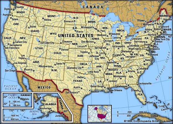
The total area of the United States (including the District of Columbia) is 9,629,047 sq km (3,717,796 sq mi), of which 1,593,440 sq km (615,230 sq mi) are in Alaska and 16,729 sq km (6459 sq mi) are in Hawaii. The total land area of the country is 9,158,918 sq km (3,536,278 sq mi). Inland, coastal, and Great Lakes bodies of water occupy 470,129 sq km (181,518 sq mi) of the total area. Measured along the parallel of latitude that passes through West Quoddy Head, Maine, the easternmost point in the United States, the maximum width of the conterminous 48 states is 4421 km (2747 mi). The maximum length measured from the vicinity of Brownsville, Texas, due north to the Canadian border is 2572 km (1598 mi). The boundaries of the United States extend along the Atlantic and Pacific oceans, along the Gulf of Mexico, and along land areas. The northern boundary is some 6420 km (some 3990 mi) long; the southern boundary, 3111 km (1933 mi); and the boundary between Alaska and Canada, some 2480 km (some 1540 mi). For the United States, the Atlantic coastline is 3330 km (2069 mi) long; the Pacific coastline, including Hawaii, 12,268 km (7623 mi); the Gulf of Mexico coastline, 2625 km (1631 mi); and the Arctic coastline of Alaska, 1706 km (1060 mi). Mount McKinley, or Denali (6194 m/20,320 ft), in Alaska, is the highest point in North America; Death Valley, a depression 86 m (282 ft) below sea level, in California, is the lowest point. The mean elevation of the United States is about 760 m (about 2500 ft) above sea level. The United States has an enormous variety of physical features and a wide diversity of animal and plant life. Besides the discussion below, much information is given in the separate articles on the states, as well as those on important mountains, rivers, lakes, and other physical features. The present-day pattern of the landforms of the United States is the result of a long sequence of collisions and separations of large blocks of the earth’s surface crust. The oldest part of the continent is the Canadian Shield, or Laurentian Plateau, a mass of granite and related rock that underlies eastern Canada and the northeastern United States. The shield was formed during several long periods of crustal convergence in Precambrian time (a period that stretches from the formation of the earth to about 570 million years ago). During these slow but relentless collisions of crustal plates, the rigid surface rocks buckled and cracked. Large pieces of crust were forced downward into the hot interior of the earth, where they warmed and eventually melted. This lighter molten material then moved upward through the crustal cracks, occasionally erupting as a volcano, but more often pushing surface rock upward in a broad bulge, or dome. In time, the molten material cooled and crystallized. The characteristic rock of the shield is granite, a slowly cooled and therefore coarse-grained rock. The margins of the ancient continent are more complex in structure, with zones of granite, darker ocean-bottom rocks, fine-grained volcanic rocks, hardened ocean sediments, and rocks of all types that were altered by heat and pressure during later crustal activity. The iron deposits of Minnesota, Upper Michigan, Wisconsin, and northern New York all occur in contorted rocks near the edges of the ancient shield. A long period of inactivity in the crust followed the formation of the shield. Erosion reduced the mountainous continent to a low plain, and the adjoining seas were filled with thick beds of sediment. Near the end of this period, great forests covered the land, and the addition of organic material to the sediment formed the vast coal and petroleum layers that stretch in a broad curve from northern Pennsylvania through West Virginia to Alabama, then west to Texas and northwest through the Great Plains states and Canadian prairies to Arctic Alaska. The period of crustal calm ended when the North American and European landmasses collided early in the fossil-forming period; southern Massachusetts and Rhode Island are actually parts of the European landmass that became attached to the American plate at this time. Later, after the coal-forming age, the African and American landmasses converged. The modern Appalachians are the worn-down remnants of lofty mountains that were built during this majestic collision. This was an age of earthquakes and volcanoes, the same kind of intermittent but relentless geologic activity that characterizes California, Washington, and Alaska today. Crustal uplift and subsequent erosion exposed ancient granite rocks all the way from New England to Alabama, as evidenced in the low Piedmont hills of Georgia and the Carolinas and the somewhat higher Blue Ridge Mountains of North Carolina, Virginia, and West Virginia. To the west, the layers of younger sedimentary rocks still remain at the surface, crumpled and eroded, notably in the long, even ridges and valleys of central Pennsylvania, eastern Tennessee, and the Ouachita region of Arkansas and Oklahoma. Still farther west and north, less intense folding created broad domes and basins. Present-day Michigan and Iowa occupy geologic basins. Structural domes are centered near the Wisconsin Dells, the Bluegrass area of Kentucky, and the Nashville area of Tennessee. After the Appalachian collision, the continent reversed direction and drifted west. The Atlantic Ocean began to widen, and the eastern United States again became a region of geologic calm. The lofty Appalachians began to erode, and the resulting sediment accumulated on the midcontinental Great Plains and on the Atlantic and Gulf coastal plains. Meanwhile, new ranges of mountains were rising as the western United States collided with the Pacific Plate. Lava erupted onto the surface in many places at different times: in northern New Mexico, central Arizona, eastern California, and southern Idaho, and especially in the region of the Cascade Range of Oregon and Washington. The sandy sediments of the Great Plains were thrust sharply upward along the Front Range of the Rocky Mountains in Colorado and Montana and around smaller mountain ranges such as the Black Hills of South Dakota. Rock movement along massive faults formed California’s Sierra Nevada, Utah’s Wasatch Range, Nevada’s aligned mountain ranges, and the Teton Range in Wyoming. The land of Arizona and southern Utah was lifted, and rivers cut canyons in the level sedimentary rocks. The motion of crustal plates thus accounts for the broad panorama of the landforms of the United States. Interpreting the finer details of the present-day landscape requires consideration of the effects of past and present climates. The major past climatic event is the Pleistocene Epoch, more commonly known as the Ice Age. At least four times in the past 1 million years, great ice sheets formed in eastern Canada and the mountains of the west and spread outward. The moving ice, like a powerful bulldozer, scraped soil and rock from Canada and the northern United States and deposited material farther south. The aligned lakes and exposed rocks of New England and northern Minnesota are results of glacial scouring. Long Island and Cape Cod are huge glacial deposits, characterized by hills composed of rock and soil, with associated swamps and sand outwash plains; similar features are abundant throughout the former glaciated areas, from New England to the Dakotas and in the western mountain valleys. Rivers such as the Hudson, Illinois, Minnesota, Missouri, and Columbia carried huge floods of glacial meltwater and carved valleys much larger than the present-day streams require. Glacial meltwater also formed many large lakes. Today level plains mark the beds and low beach ridges mark the shores of Ice Age lakes on both the eastern and western edges of Vermont, around the Maumee River of northwestern Ohio, in the sand counties of central Wisconsin, around the Red River of Minnesota and the Dakotas, around the Great Salt Lake of Utah, and in the Missoula Basin of Montana, the Central Valley of California, and hundreds of smaller areas in many states. Ice Age dust storms left thick deposits of loess (fine-grained silt or clay) on the undulating plains around the Mississippi River and Missouri River, on the steeper bluffs of western Wisconsin and western Tennessee, and in the Palouse Hills region of eastern Washington. Times of higher sea level built beaches far up on the Gulf Coastal Plain and on slopes overlooking the Pacific Ocean; on the other hand, Chesapeake Bay and many similar drowned river valleys along the Atlantic coast from Georgia to Connecticut are results of periods of lower sea level. The climate of a place is the seasonal pattern of its inputs of solar energy, wind, and precipitation. With the exception of the principal islands of Hawaii, no place in the United States ever sees the sun directly overhead. In general, sun intensity and, consequently, temperatures decrease from south to north; in summer, however, the decrease in intensity is partly offset by longer days in the north. Montana, North Dakota, and Minnesota actually have higher record temperatures than New Mexico and Alabama. In winter, on the other hand, the short days in the north exaggerate the effect of low sun angles, creating wide temperature differences from south to north. Forests use much solar energy to evaporate water, and therefore the humid states of the eastern United States do not get as warm as the dry western deserts. Oceans and lakes moderate temperatures; this is especially true of the western coast, where the ocean is cool and the wind is usually onshore. Finally, mountains are somewhat cooler by day and much colder at night than surrounding lowlands. Effects of each of these factors can be seen in the accompanying table of temperatures. The pattern of precipitation is largely a consequence of the interaction of wind and topography. The wind system of the earth behaves with one simple goal: to equalize temperatures on earth by taking heat from the equator and carrying it to the poles. The process is grand in scope and complex in detail. Two features of global atmospheric circulation are particularly significant for the United States. One is a current of sinking air, a gentle, but persistent, downward movement of air from the upper atmosphere. This subsidence is part of the global convection cycle and starts with updrafts of warm and humid air near the equator; the air loses moisture as it rises to the upper atmosphere and begins to move poleward. At about latitude 30� north the air begins to sink, bringing hot and dry conditions to the southwestern United States, especially in summer. The other significant part of atmospheric circulation is the jet stream, a shifting zone of fast winds blowing generally from west to east high above the ground. The path of the jet stream on any given day is a key to surface weather. In summer, the jet stream is usually near the Canadian border, although on any given day it may loop as far north as Alaska or as far south as Louisiana. The jet brings wet Pacific air onshore in Washington and Alaska, but in other western states dry air masses from Mexico and Canada dominate. In the east, by contrast, the jet can pull moist air masses northward from the Gulf of Mexico all the way to Canada. In winter, the entire wind system follows the sun southward. Pacific air masses now bring clouds and rain to the coastal mountains from California to southern Alaska. The jet usually crosses the country at the latitude of Oklahoma, and cold, dry Canadian air covers the northern half of the country; however, day-to-day shifts of the jet may pull warm, moist Gulf air as far north as Illinois or bring Canadian air to Florida. Regional weather hazards are intimately associated with the seasonal position of the jet stream and associated fronts. Torrential rains are most common in the United States near the Gulf of Mexico, which is the major source of moisture for the country. Tornadoes occur in the center of the United States, where Canadian and Gulf air masses often collide violently. Southern California has smog episodes and forest fires in late summer, when the jet stream and its associated rain are far to the north and the hot, dry sinking air from the tropical circulation dominates the weather. Hurricanes arise out of the late-summer warmth of the Atlantic Ocean and drift toward the southeastern states in the autumn. Heavy winter snows in the eastern United States are caused by the rapid cooling of the Gulf air, amplified in the Great Lakes region by local lake breezes. December and March are the major snow months in Minnesota and the Dakotas; January there is a time of intense cold and little snowfall, because Gulf air cannot penetrate this far north in midwinter. Finally, the occasional kona (west coast) storms of Hawaii are wintertime incursions of North Pacific air that occur when the jet stream curves far to the south. Normal weather consists of trade winds that cause rain only on the northeastern slopes of each island. Rivers respond to the quantity and seasonal pattern of precipitation in a region. The streams of the eastern United States, principal among which are the Hudson, Delaware, Susquehanna, Potomac, and Savannah, receive rainfall in every month and therefore are reliable avenues for waterborne commerce. Rivers of the interior, such as the Ohio, Tennessee, Illinois, and Mississippi, often flood in spring and decrease in size during the hot weeks of late summer and the snow months of winter. Some flow regulation and flood control have been achieved on these rivers through a costly and controversial system of dams and levees. Argument over water projects is even more heated in the western United States, where mountain snowmelt is the principal source of water for the eastward-flowing Missouri, Platte, Arkansas, and R�o Grande rivers and the westward-flowing Colorado, Sacramento, Snake, and Columbia rivers. Most of these rivers shrink in volume as they flow away from their mountain sources; some, like the Colorado, are dammed and diverted for so many urban or agricultural uses that they no longer carry water to the sea. Along the Pacific seaboard are a few coastal streams that have their seasonal peaks during the winter rainy season. In Alaska the drainage system is dominated by the Yukon, a river as long as the R�o Grande but considerably greater in volume. The surface water sources of the nation also include the five Great Lakes, which occupy an interconnected set of glacially scoured basins and together serve as a major transportation artery. Glaciers also left tens of thousands of smaller lakes throughout the northeastern United States, the upper Midwest, and much of Alaska. Among the larger of these are Champlain, Winnipesaukee, and Cayuga in the northeast and Winnebago, Red, and Mille Lacs in the Midwest. The Great Salt Lake of Utah and many smaller salt basins of the Mountain states are remnants of much larger Ice Age lakes. Many groundwater aquifers, especially those of the Great Plains, are also relics of wetter climates of the past. Soils, like landforms, are formed by the action of climate on surface material. The central Interior Plains are just far enough south to have adequate heat for rock decomposition and plant production during the growing season. The moisture balance here is also generally favorable: enough rainfall for crops but not so much that vital nutrients will be leached from the soil. Farther south, excess heat accelerates the chemical weathering and stimulates the growth of microorganisms, which consume organic residues and leave a less fertile red or yellow mineral soil. In the humid east and northeast, surplus water seeps down through the soil and removes valuable nutrient salts. At the other extreme, soils in the dry climates of the west and southwest can accumulate salts, often to levels that are toxic to plants. During the Ice Age, glaciers scoured material from the already thin and poor soils of the north and moved a substantial amount of earth southward. Illinois, Indiana, Iowa, and Ohio were the principal beneficiaries; many parts of these states had more than 30 m (100 ft) of new earth laid down as gently undulating till plain. Parts of New England, New York, Michigan, Wisconsin, and Minnesota also gained material, but often of a more coarse and rocky nature. Meltwater floods filled many valleys in the Midwest and West with rich sediment, and upland soils were often enriched by fine windblown dust. The United States can thus be divided into five major soil regions that are a result of these continuing formative forces: (1) the deep, black mollisols of the midcontinent (the country’s most fertile), in an area stretching from Illinois west to Nebraska and the Dakotas; (2) the leached red ultisols of the southeastern and western coast mountains, which are considerably less fertile; (3) the coarse and acid spodosols in the northeastern United States and in the high western mountains; (4) the moderately fertile gray or brown alfisols found around the Great Lakes, on the southern Great Plains, and in the Central Valley of California; and (5) the dry, salty aridsols of the desert Southwest. Superimposed on these broad patterns are local geologic exceptions, such as the black clay vertisols of Texas and the organic histosols, which are peat and muck soils found in swampy places such as the Florida Everglades or the Minnesota bogs. Younger soils, such as entisols and inceptisols, occur on shifting sand dunes, recent volcanoes, river floodplains, and steep slopes, where disturbances such as floods or landslides prevent the development of mature soil profiles. These immature soils range from barren rock outcrops in Arizona and grassy sandhills in Nebraska to fertile volcanic ash soils in Hawaii and the extraordinarily productive floodplain of the Mississippi River. Because plants respond directly to local climate and to a lesser degree to local topography, the indigenous vegetation of the United States is marked by great diversity. In regions other than those dominated by forests are a wide variety of plants that are adapted to colder or drier conditions. At the time European settlement began, about one-half of the United States was covered by forests. Today, because of extensive human modification, about 30 percent of the country’s land area is forested (although in the 1990s the amount of forested land was increasing). Grasslands and other natural vegetative cover decreased in extent as the continent was settled. Northern Alaska, located in the northernmost part of the United States, is characterized by a windswept tundra, a region of lichens, mosses, hardy low shrubs, and flowering plants. Inland and to the south, the growing season lengthens and certain trees can survive. A few species of needle-leaf trees, notably spruces and firs, dominate a vast but slow-growing evergreen forest, interspersed with lichen-covered rocky areas, grassy swamps, and aspen-choked fire scars. This forest, known as the taiga, stretches southeast from interior Alaska and has small outliers in northern New England and the Great Lakes region. South of the taiga the growing season is still longer and more tree species can survive. Here is found a mixed forest containing both needle-leaf and broadleaf trees, and including pines, maples, elms, birches, and oaks, as well as hickory, beech, and sycamore. This type of mixed forest covered the region around the Great Lakes and most of the New England and Middle Atlantic states when European settlers arrived. Still farther south, the frost-free season exceeds six months, rainfall becomes more reliable, and the forest reaches its maximum diversity. The Great Smoky Mountains National Park in western North Carolina and eastern Tennessee contains more tree species than the entire continent of Europe. The Gulf of Mexico coast is even warmer than this mountainous area, but its plains and low hills do not support as complex a forest. Moreover, the sandy soils and hot summers encourage fires, which suppress oaks and other hardwoods and favor the fast-growing pines that now represent the major forest resource of the nation. Other species found here include southern magnolia, pecan, red gum, and black gum (tupelo). A number of subtropical and tropical trees flourish in southern Florida. Along the coast of the Gulf of Mexico, salt marshes and groves of cypress and mangrove help to armor the shore against the eroding forces of wind and water. The diversity of the forest also decreases west of the Appalachian Mountains. First, the mountaintop spruces, firs, and mountain ashes disappear. Then, rainfall decreases in quantity and reliability, and fires become more frequent. The lush bottomland hardwood forests of the Mississippi Valley slowly dwindle in size and complexity. Oak-hickory forests give way to isolated stands of oak and then to tall grass prairies, which, before cultivation, occupied the present Corn Belt from Indiana to the eastern Great Plains. Farther west, the climate becomes still drier, and the tall bluestem grasses yield to shorter grama and wheatgrass ranges. The grasses of the northern Great Plains grow only during the short summer and flower in late summer or early autumn. By contrast, the grasses of the southern Great Plains grow rapidly in spring, flower early, and then go dormant during the hot, dry summers. Both kinds of grass become less productive as rainfall continues to diminish toward the west. Shrubby sagebrush (in the north) and mesquite and juniper (in Texas) are typical invaders on poorer grasslands that have been overgrazed or protected from fires. A gradual transition to true desert vegetation is interrupted by the Rocky Mountains and other ranges, the elevation of which both increases rainfall and decreases temperature and evaporation. Trees become prominent on the lower and middle slopes. Hardy pines and junipers dominate at lower elevations, giving way to aspens, firs, and spruces at higher elevations. Still higher, the spruces and firs become stunted and widely spaced. Above this zone is treeless tundra, outwardly similar to Arctic vegetation, although the two kinds of tundra have different patterns of solar radiation, day length, and diurnal (day-to-night) temperature changes. Shrubby low-lying deserts alternate with forested (and occasionally tundra- or ice-capped) mountains across all of the Mountain states and into the Pacific states. This region is agriculturally productive only when massive investments are made in irrigation. Death Valley, which lies below sea level, is but one of the many nearly barren lowlands. Vegetation in these regions includes species such as sagebrush, juniper, pi�on, rabbitbrush, mesquite, creosote bush, and yucca; the cactus "forests" that form a popular image of deserts are actually found on the slopes of mountain ranges in the Mojave Desert of southern Arizona and California. On the higher but still relatively dry Colorado Plateau are found ponderosa and pi�on pines. The hot, dry summers and mild, moist winters of coastal southern California produce a distinctive shrub vegetation known as chaparral. The plants here have adapted to rainy winters, dry summers, autumn fires, and thin soils. Farther north on the western slopes of the coastal hills and Sierra Nevada, the winter rainy season is longer; forests of giant sequoia and redwood occupy this favored location, where there is enough rain to permit rapid growth but a long enough dry season to discourage competition from numerous species. Still farther north, in western Oregon and Washington, a true rain forest appears as the dry periods shrink to less than a few weeks in midsummer. This luxuriant forest consists primarily of a great variety of needle-leaf trees: Douglas firs, true firs, hemlocks, cedars, spruces, and pines, each occupying its own preferred elevation zone here, and together constituting the second richest forest resource for the nation. The coastal forests of Alaska have fewer species than the rich rain forest to the south but a faster growth than the taiga to the north. The natural vegetation of Hawaii is conditioned by its isolation, which has served to limit the number of species, and by the interplay of its mountains and the moist trade winds. Forests dominated by guava trees on the windward (northeast) coasts of the islands grade upward to a rich but swampy rain forest at moderate elevations, where the annual rainfall may exceed 10,000 mm (400 in). The high mountains support shrub forest, and patches of tundra are found on the summits of the highest peaks, Mauna Loa and Mauna Kea. The dry leeward (southwest) coasts are virtual deserts, with spiny koa and kiawe shrubs growing on the slightly wetter slopes.Animals depend, either directly or indirectly, on plants for their survival. Each major vegetation region thus has its own characteristic kinds of animal life. In the Arctic areas and regions of mountain tundra are found burrowing marmots, ground squirrels, cold-water fish such as grayling and trout, and an occasional bear. Alaskan coastal waters are the habitat of a number of large mammals, including walrus and fur seals. Caribou and elk spend summers on the tundra but migrate into the conifer forest for winter. Many birds migrate even farther, going from the polar regions to the Tropics each winter. The hardwood forests of the eastern United States contain moose, black bears, deer, foxes, raccoons, skunks, squirrels, and a diversity of small birds. Along the Gulf of Mexico coast live larger and more colorful birds such as pelicans, flamingos, and green kingfishers, as well as alligators and warmwater fish such as catfish. Several varieties of venomous snakes are also found here. Bison (buffalo) are popularly associated with the grasslands, although in fact they once ranged over most of eastern North America before being nearly exterminated by hunting; they now exist only in captivity or in protected areas. Gophers, rabbits, prairie dogs, ferrets, ants, and other burrowing creatures are best suited to the grasslands, which were once swept by fires. The mountainous western states, especially Alaska, are the last refuges in the United States of most big-game animals. Here may be found elk, pronghorn, moose, deer, bighorn sheep, mountain goats, timber wolves, and, in a few remote areas, brown bears. The Kodiak bear, the largest carnivore in North America, is found in Alaska. The deserts have few plants, fewer small animals, and almost no large animals. Kangaroo rats, lizards, and wide-ranging birds are typical animals in this harsh region. The animals of Hawaii include many endemic species (those not found elsewhere), but many of these have been driven to near extinction by human alteration of the habitat and by competition from introduced animals. Hawaii’s only indigenous mammal is the bat. The United States is exceedingly rich in natural resources. The country’s climate is favorable for a diversity of crops and forest products. The Corn Belt, a region stretching from western Ohio to central Nebraska, is the largest expanse of prime farmland in the world. Significant deposits of many important minerals, including more than a fifth of the world’s coal, are present within the country’s borders. Despite this wealth, the United States cannot produce all the resources needed by its large industrial economy. The country imports more than 80 percent of its bauxite, magnesium, platinum, tin, and tungsten. The United States in the mid-1990s produced 57 percent of its petroleum needs, but new domestic discoveries tend to be small and costly to recover, especially in the geologically complex mountain regions and the deep waters of the continental shelf. Agricultural exports have helped compensate for mineral imports, but the price is high. More than a third of the nation’s topsoil has been lost to erosion. Gullies and other obvious scars common in the 1930s can now be repaired by modern heavy machinery, but soil losses caused by less noticeable sheet erosion are still high on more than half the nation’s farmland. Many observers have also expressed concern about the rapid conversion of prime cropland to urban and other nonfarm uses. Despite these trends, the environmental picture of the United States is not all bleak. Because of government regulations, water pollution diminished considerably during the 1970s; forests are growing more rapidly than they are being cut in most regions; and substantial areas have been set aside as wilderness preserves and national parks. The federal government and most of the states have adopted laws that require investigation and public disclosure of the environmental impact of proposed projects. These procedures have helped to increase public awareness of the environmental costs of certain activities. In the future the questions of acid rain, toxic waste disposal, water supply, and climate change will continue to be major national environmental issues. The supreme law of the land is the Constitution of the United States. The Constitution was drafted by a convention in 1787, was ratified by the required two-thirds of the states by June 1788, and was put into effect in 1789. The Constitution may be amended by a two-thirds vote of each house of Congress or by a special national convention called for the purpose, subject to ratification by vote of three-fourths of the legislatures of the states or state conventions. The first ten amendments, known as the Bill of Rights, were adopted in 1791. These provide for freedom of speech, freedom of religion, freedom of the press, the right to assemble, the right to petition the government, and various due process and criminal procedure rights for individuals. Seventeen additional amendments were adopted between 1795 and 1992, abolishing slavery, providing for an income tax, and providing for universal suffrage for all people 18 or older, among other purposes. The Constitution provides for a union of states, now numbering 50, each with its own constitution, republican form of government, and reserved powers, within a federal system. The national government is responsible for external affairs and has concurrent powers with states, commonwealths, and self-governing territories over domestic matters. The chief of state is the president of the United States and the seat of government is the District of Columbia, which has limited home rule and no voting representation in the national legislature. The Constitution establishes three separate branches of government: the legislative, executive, and judicial. Each branch has its own area of authority. These areas overlap, making it necessary for the three branches to share in, and compete for, the power to govern effectively. Each branch has some constitutional authority that it can use to impede the functioning of the other branches, creating a system of checks and balances. The purpose of this somewhat cumbersome machinery of government, as intended by the framers of the Constitution, is to prevent the concentration of power in a small group of politicians, which could lead to tyranny. Since the adoption of the Constitution, the national government has increased its functions in economic and social matters and has shared more responsibilities with the states.Article II of the Constitution provides for a president and vice president chosen by a majority of voters in the Electoral College, for a fixed term of four years. The 22nd Amendment (1951) limits presidents to two terms in office. By state law, electors are chosen by a plurality of the popular vote in each state and in the District of Columbia. In almost all cases the winner of the popular vote is elected president. In the 1984 presidential election, less than 55 percent of eligible voters cast their ballots; after a decline to approximately 50 percent in 1988, turnout increased to approximately 54 percent in 1992. But in 1996, voter turnout fell to an estimated 49 percent. The American president typically has a greater range of functions than prime ministers in parliamentary governments because the president serves as ceremonial chief of state as well as head of government. Unlike most presidents in other nations, the American president is also the head of his or her party, an important legislative leader, and the chief executive. The Constitution makes the president commander in chief of the U.S. armed forces. The president defends the nation against invasion or attack and may order American armed forces into combat. The president’s authority to deploy forces on his or her own initiative is regulated by Congress under Article I, Section 8, which reserves to Congress the power to declare war, and under provisions of the War Powers Resolution of 1973. The president’s diplomatic powers include negotiation and ratification of treaties, with the consent of two-thirds of the Senate; the appointment of ambassadors to foreign nations, also with the consent of the Senate; and the reception of foreign ambassadors. The president negotiates, on his or her own authority, executive agreements with leaders of other nations. By law the president prepares an executive budget and an economic report, which are submitted to Congress each year. The president submits requests for legislation, the most important of which usually regard taxation and other economic and military matters. The president also exercises executive authority over the various government departments and agencies. An extensive advisory system serves the president. Aides in the White House, where the president resides and has offices, provide advice, manage press relations, schedule appointments and travel, and communicate with Congress, government departments, lobbying groups, and the president’s political party. Staff agencies in the executive office include the Office of Management and Budget, which prepares presidential budget requests and controls spending; the National Security Council, which is concerned with the nation’s defense; and the Council of Economic Advisers. The President’s cabinet also serves as a source of information and advice. It consists of the heads of the governmental departments and a few other officials, such as the director of the Central Intelligence Agency and the U.S. ambassador to the United Nations (UN). The cabinet has no power of its own. The executive branch of the government comprises 14 departments: the Department of State, Department of Treasury, Department of Justice, Department of the Interior, Department of Agriculture, Department of Commerce, Department of Labor, Department of Health and Human Services, Department of Education, Department of Housing and Urban Development, Department of Transportation, Department of Energy, and Department of Veterans Affairs. Some government agencies are not directly supervised by the president. These include independent establishments such as the Federal Communications Commission and the Federal Reserve System. All legislative powers granted by the Constitution in Article I are exercised by the Congress of the United States. Congress consists of two houses, the Senate and the House of Representatives. The Senate contains 100 senators, two representing each state—a provision of the Constitution not subject to amendment. The 435 members of the House are elected by the different states on the basis of their population at the most recent U.S. census. California has the largest number of representatives, 52; several states, such as Delaware and Vermont, have only 1. Representatives serve two-year terms, and senators six-year terms. Every two years all 435 members of the House are elected, and one-third of the senators. In presidential election years, about 45 percent of eligible adults vote for members of Congress; in other election years, only about 35 percent vote. The Senate and House are organized by the majority party in each chamber, which chooses the presiding officer, the majority leader, and the chairpersons of each committee. Through much of American history the party controlling the White House did not control both houses of Congress. This situation, known as divided government, can lead to reduced output of legislation and an increase in presidential vetoes of bills passed by Congress. Unlike the chief executives of parliamentary systems in other countries, the U.S. president neither resigns nor calls for new elections, even when majorities in Congress reject the president’s programs. Congress has extensive powers in domestic affairs, including the power to tax, borrow money and pay debts, coin money and regulate its value, and regulate commerce among the states. Congress helps to establish and oversees the departments and agencies of the executive branch; it also establishes the lower federal courts and determines their jurisdiction. Congress has the power to declare war, raise and maintain the armed forces, establish tariffs, and regulate commerce with foreign nations. A bill is passed by Congress by majority vote of those present in each chamber; it is then sent to the president. The president may sign the bill, to indicate approval, or allow the bill to become law without signing it; or may veto the bill and return it to Congress, giving reasons for this action. The president’s veto can be overridden by a two-thirds vote of the members of Congress voting in each chamber. Each house of Congress has some distinct powers. Revenue measures must originate in the House of Representatives. The House, with a majority vote, can initiate proceedings to impeach (charge with misconduct) the president. If the Electoral College cannot produce a majority to elect a president, the House chooses one of the top three contenders. If both the president and the vice president die, are incapacitated, or are removed from office, the Speaker of the House becomes president. The Senate advises and consents to presidential treaties and to nominations for major executive officials, ambassadors, justices of the Supreme Court, and federal judges. The Senate tries all impeachments, with a two-thirds vote necessary to convict. In the event of a deadlock in the Electoral College, the Senate chooses the vice president from the top two contenders. The president pro tempore of the Senate comes after the Speaker of the House in the line of succession to the presidency. The legislative branch also includes agencies such as the Congressional Budget Office, the General Accounting Office, the Library of Congress, and the Government Printing Office. The federal court system derives its powers from Article III of the Constitution. The system includes the Supreme Court of the United States, established by the Constitution; and 12 courts of appeal (sometimes called circuit courts), 91 district courts, and special courts such as the Tax Court, the Claims Court, and the Court of Veterans’ Appeals, all established by Congress. The federal courts perform two constitutional functions. First, they interpret the meaning of laws and administrative regulations; this is known as statutory construction. Second, the courts determine whether any law passed by Congress or state legislatures, or any administrative action taken by the national or state executive branches, violates the U.S. Constitution; this is known as judicial review. Federal courts can declare null and void laws or actions, at the national and state levels, that violate the Constitution. This power of judicial review exists in a few other nations, but in none is it so significant in resolving important issues or in checking and balancing branches of government. The nine justices of the Supreme Court and the other federal judges are nominated by the president with the advice and consent of the Senate. The president, in making district court nominations, usually follows the recommendations of senators from the president’s party. All federal judges and justices of the Supreme Court serve on good behavior for life. They may be removed from office only through the process of impeachment, which has been used fewer than 20 times, and never successfully against a Supreme Court justice. Decisions of the Supreme Court that involve the statutory construction of laws may be overturned by Congress. Decisions involving judicial review may be checked and balanced in either of two ways. The president and Senate may deliberately fill vacancies on the Supreme Court with new justices who can be expected to overturn the decision; or the Constitution can be amended, as was the case after the Supreme Court ruled income tax unconstitutional. The U.S. Constitution provides for a federal system, with those powers not exercised by the national government retained by the states. States are denied the power to conduct foreign relations, enter into treaties or alliances, or lay tariffs. They may not coin currency, levy taxes on interstate commerce, or prevent the movement of persons across their borders. States may cooperate with one another through creation of interstate compacts, which require the approval of Congress. These often involve water resources, navigation, pollution control, or port development. The national government and states are closely linked in an administrative system of cooperative federalism. This includes categorical grant programs, in which the national government establishes operating standards and pays up to 90 percent of the cost of programs administered by the states; block grants for general purposes such as education or community development; and revenue sharing, whereby the national government distributes money to states and localities each year. The major functions of the states include qualified control of voter eligibility requirements; administration of state and national elections; supervision of municipal and county government; promotion and regulation of commerce, industry, and agriculture; and maintenance of highways, prisons, hospitals, and mental-health facilities. The states also support extensive systems of higher education. They share with local units of government the responsibility for welfare, medical care for indigents, employment services, and other social services. Almost all states are divided into territorial units called counties. In 1992 the United States had 3043 counties. Louisiana is divided into 64 parishes, which are similar to counties. Alaska has no counties as such; much of the state is organized into 16 boroughs. In a number of states, such as Connecticut, counties have virtually no governmental function. In several states, notably Virginia, one or more cities are independent of any county organization and thus constitute primary divisions of the state. In relatively heavily populated areas, communities are organized into a total of 19,296 municipalities, which include cities, towns, villages, and boroughs. Municipalities generally provide basic services, including police, sanitation, and fire protection. Education at the elementary and secondary levels usually is supervised by school boards, which share authority over finance, curriculum, and teacher certification with state government; the United States had 14,556 school districts in 1992, down from 108,579 in 1942. Also important are so-called special districts, which are independent, limited-purpose local government units dealing with water supply, flood control, fire protection, community development, housing, and other matters. The United States had 33,131 special districts in 1992. Two major political parties existed in the United States in the 1990s. The Democratic Party was founded in the 1790s as the Anti-Federalists, became the Democratic-Republican Party in 1801, and was renamed the Democratic Party in 1828. The Republican Party was founded in 1854 as a third party and became one of the two major parties in 1860. Parties other than the Democratic and Republican parties are of minor importance in most national and state elections, and no third-party candidate has ever won the presidency. Third parties have played only a minor role in Congress. In the late 20th century the Democrats were split into two major factions. The northern Democrats as a rule favored national action to solve social problems, emphasized government regulation of the economy, and favored strong action to aid minorities. The southern Democrats were more conservative in fiscal, economic regulation, and social matters. Republicans were less divided in their economic approach, favoring reduced social services to help balance the budget to lower inflation, and tax cuts to promote industrial development. Division among Republicans occurred on social issues involving such matters as abortion and civil rights, however. Through cooperative federalism, the national and state governments provide social services to individuals. The Social Security Act of 1935 provides financial protection to wage earners and their families when the wage earner retires, becomes disabled, or dies. Contributions are financed through payroll taxes and employer contributions, and benefits are indexed against the effects of inflation. The national government and states also help fund unemployment insurance programs. Health programs include Medicare, a health insurance program for senior citizens, and Medicaid, a program of assistance to the poor. The United States has extensive medical facilities of the highest quality, but gaining access to them remains a problem for a substantial segment of the population. It has been estimated that more than 30 million Americans have no private health insurance coverage and do not qualify for Medicare or Medicaid; perhaps twice that number either have inadequate basic coverage or do not have adequate coverage for catastrophic illness. Federal, state, and local grants provide income assistance for the blind, disabled, and elderly poor, and assistance to poor families with dependent children. School lunch programs for needy children and a food stamp program for poor families are also provided. The president is commander in chief of the U.S. armed forces. The president’s orders commanding these forces are passed through the office of the secretary of defense to the various military commands. The military heads of the army, navy, air force, and marines serve as the Joint Chiefs of Staff, whose chairperson is designated by the president; United States Navy; United States Air Force; United States Marine Corps). The Joint Chiefs of Staff advise the president and Congress on military strategy and recommend expenditure levels and weapons systems. Although the Selective Service System registers all male citizens over the age of 18, since 1973 the armed forces have been composed entirely of men and women volunteers. In 1998 the armed forces consisted of 1,395,800 active-duty military personnel, including 488,000 in the army, 372,700 in the navy, 172,200 in the marines, and 370,900 in the air force. The United States Coast Guard had 37,300 members in the mid-1990s. United States reserve forces numbered about 1.5 million in 1996. Major collective security agreements to which the United States is a party include the North Atlantic Treaty Organization and ANZUS, which links Australia with the United States. The United States is a member of the United Nations and has a permanent seat on the UN Security Council. It also belongs to many UN agencies such as the International Bank for Reconstruction and Development, the International Labor Organization, and the International Monetary Fund. In addition, the United States plays a major role in numerous other international organizations, such as the Organization of American States and the Organization for Economic Cooperation and Development. |
|