|
ABBEYKNOCKMOY
Map Reference: M506436
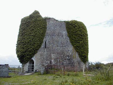
Abbeyknockmoy has a pointed west doorway surmounted by a single-light window with ogee head. The church had north and south
aisles, each of four bays with broad dividers. Only the two most westerly arches are unblocked on both aisles. The cruciform
church has two east chapels in each of the transepts. The chancel has three short lancets in the east wall and these are surmounted
by a single lancet. There is good vaulting over the chancel. It is inaccessible at present but the wall paintings for which
the abbey is famous are visible through the gate. The cloister lay to the south of the church but there is no arcade in place.
The chapter house in the east range was originally a large vaulted room lit by five narrow decorated lancets. It has now been
divided into three by a solid wall and a three-bay arcade. These dividers encroach on two of the lancets. Fragments of carved
stone, stored within the ruin, indicate that the cloister arcade had dumbbell-shaped pillars.

ANNAGHDOWN ABBEY
Map Reference: M287379
At Annaghdown the Abbey of St Mary de Portu Patrum may have been founded by Turlogh O Conor. This has a long church with a
pointed north doorway, an early round-headed north window in the chancel and a larger south window. This has a round hood-mould
with beastly heads as stops. To the south is the ruin of a long two-storey building and to the west of this is an open area
which marks the site of the cloister. There are fragments of buildings to the south of the cloister garth and within this
is a collection of Romanesque fragments. This includes two pillars with diamond patterns and carved capitals which feature
human heads with intertwined hair and beards.
ANNAGHDOWN CATHEDRAL
Map Reference: M288280
Annaghdown Cathedral has an inserted east window. It is a round-headed window with a richly decorated Romanesque frame. There
are triangular panels containing mainly floral motifs and at least one beast. There are intertwined and curling beasts at
the ends. Outside there is a round hood mould. A short distance to the north are several low church ruins.
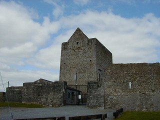
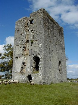
ATHENRY CASTLE
Map Reference: M505280
In 1235 Richard de Burgo granted a charter to Meiler de Bermingham who completed the building of Athenry Castle about 1250.
It is a three-storey tower surrounded by a strong wall. The basement has a vault carried on three pillars. The doorway is
at first floor level and is reached now by a modern stairway. It has capitals decorated in the Irish Romanesque fashion.
THOOR BALLYLEE
Map Reference: M482062
This is a four-storey 16th century tower-house. The castle and the adjoining cottage were repaired and lived in in the 1920s
by the poet W B Yeats. When he left in 1929 it became ruinous again. In 1965 it was restored as a Yeats museum.
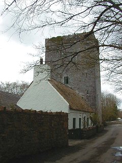
CAHERDANGAN CASTLE
Map Reference: M527201
Caherdangan or Strongfort is a 15th century Burke castle. It is now restored and lived in.
CASTLE TAYLOR
Map Reference: M467142
Castletaylor is a tower-house which has had two large traceried three-light windows
inserted in its east wall. The mullions from these windows appear to be much heavier than the tracery and do not match. The
windows are said to have come from the churches at Kilmacduagh. The pointed north doorway was protected by a long narrow slit
just above it instead of a machicolation. The tower seems to be about four storeys high and has a good base batter. It has
a groined vault above the first floor. There is a small guard chamber to the right of the doorway and a mural stair rises
to the left. At the other end of the building is a balancing tower of three storeys with gabled dormers, which have three-light traceried windows. Between the towers is a three-bay three-storey house. This
is now totally gutted. The castle has a large walled garden at the rear and a little further off is another walled yard and
a stable block.
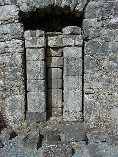
CLAREGALWAY FRANCISCAN FRIARY
Map Reference: M3713334
Claregalway Friary was founded by John de Cogan about 1250 and was richly endowed
by the de Feoris or the de Bermingham family. The nave of this rectangular church has a north aisle of four bays. Only the
aisle arcade is still in place. The west wall of the church is also missing. The south wall is lit by four short lancets and
one small two-light window. There are also three plain tomb niches in this wall and a piscina with round basins. There is
a north chapel which opens off the east end of the aisle. It has a three-light traceried north window and two two-light east
windows. One of these is decorated on the outside. There is also a very fine piscina. One of the basins is quatrefoil and
the other is octofoil. There is also a credence table. The tall central tower has a very fine vault with a hairy mask at the
centre. Some small masks at the springing of the vault. One of these is human, the others are grotesques. The north and south
walls of the chancel are each lit by six lancets and there is a very fine five light traceried east window. This window was
inserted in the 15th century and replaced lancet windows. In the north wall is a tomb niche with a decorated hood with a panel
dated 1648. In the south wall is a piscina and a fragmentary triple sedilia. The 15th century tower rises for three storeys
above the vault. The top is crenellated and there are two carved gargoyles on each side. To the south of the church is the
cloister garth but there are no remains of the cloister arcade. There are traces of two-storey buildings to the south and
east of the cloister but only a single wall on the west side. There is a fireplace at the upper level of the east range. Also
in this range is the Ryan mausoleum from 1886, last used in 1997. One of the tombstones lying in the nave depicts, among other
things, a plough. The inscription is difficult to read. There are some trapezoidal coffin lids within the church. At least
two of them have floreated crosses but they are very faint. After the Suppression the friary was granted to Richard de Burgo
in 1570. The friars were allowed to remain in or near the buildings but were driven out in 1589 by Sir Richard Bingham who
then converted the buildings into barracks.
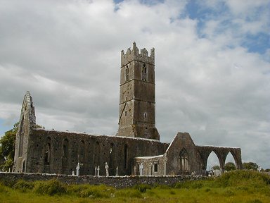
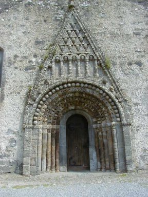
CLONFERT CATHEDRAL
Map Reference: M960210
A monastery was founded at Clonfert by St Brendan in 563 and the saint is said to be buried there. Much of the cathedral dates
from the 15th century but parts of the west wall date from the 12th century. The west doorway is probably the most magnificently
decorated Romanesque doorway in Ireland. It has six orders and an amazing variety of animal heads, human heads, foliage and
other motifs. The triangular hood above the door has ten human masks enclosed within small triangles which alternate with
other small triangles. Below this is a blind arcade of five arches each of which has a human mask within it. There are two
other masks above the hood. The innermost order of the doorway was inserted in the 15th century. The chancel arch, which is
also of this date, has some fine carving including a mermaid.
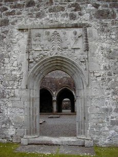
CLONTUSKERT FRIARY
Map Reference: M857258
Clontuskert Friary was founded for the Augustinians in the 12th century. The church was burned in 1413 and most of the present
building dates from the later 15th century reconstruction. The church has a very fine west doorway which is richly decorated
with figures of saints and many other motifs including a mermaid, a star and a pelican feeding her young. Inside the church
is divided by a three-bay vaulted rood screen. After the Dissolution the monastery was passed to the de Burgos.
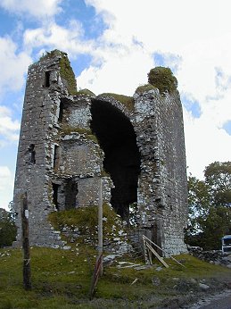
DEERPARK CASTLE
Map Reference: M547132
A small 15th century Burke castle.
DERRYMACLOUGHNA CASTLE
Map Reference: M445376
Derrymacloughna Castle has a doorway in the south west wall. It is a round-headed doorway with some pecked decoration. It
leads to a lobby with a guard chamber on the right. On the left a short curving passage leads to a spiral stairway. There
was a vault above the first floor and three storeys above that.
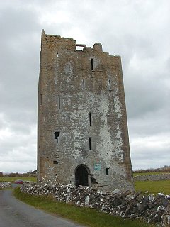
DRUMHARSNA CASTLE
Map Reference: M437106
This 16th century tower-house is known to have been owned by Shane Ballagh in 1574. It is five storeys high with a vault over
the ground floor and second floor. A spiral stairway in the corner leads to roof level. The castle was damaged when it was
occupied in the 1920s.
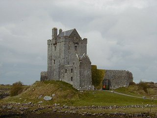
DUNGUAIRE CASTLE
Map Reference: M381106
Dunguaire or Dungory Castle is a small 16th century O' Hynes castle. The hexagonal bawn was rebult in 1642. The castle was
refurbished by Christabel, Lady Ampthill in the 1960s. It is now owned by the Shannon Free Airport Development Co who host
banquets here.
FEARTAGAR CASTLE
Map reference: M377582
This four-storey tower-house was built by the de Burgos in the 16th century. It is vaulted above the first floor. There are
two stairways within the walls. The last occupant was a lady who was dispossessed by Cromwell. It is known locally as Jenning's
Castle.
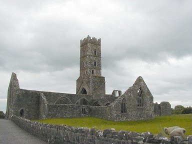
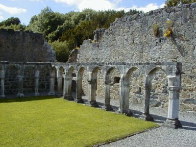
KILCONNELL FRIARY
Map Reference: M733314
Kilconnell Friary was built on the site of 6th century monastery founded by St Conall. In 1353 William O'Kelly, Lord of Hy
Many, founded a new friary for the Franciscans. Inside are two very fine tombs. One has a flamboyant traceried hood with saintly
weepers on the tomb chest. The other does not have weepers but has an equally fine hood. It was erected by the O'Daly Family.
The church has a tall vaulted tower with a fine carved owl under the vault. Part of the cloister arcade had been preserved
and features many masons' marks on the stones.
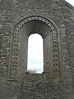
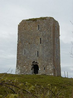
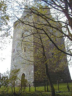
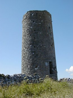
KILMACDUAGH MONASTIC SITE
Map Reference: M405000
Kilmacduagh, is the site of a 7th century monastery founded by St Colman, son of Duagh, a member of one of the local royal
families. It has a magnificent Round Tower complete with conical cap. The round-headed doorway is very high off the ground
(c 8m) and the tower seems to lean slightly. It is lit by angle-headed windows at several levels and six windows at the top.
The church to the north of the Round Tower is called the Cathedral. It had a lintelled west doorway, which is now blocked.
It probably dates to the 11th or 12th century. This was surmounted by a three-light window. The nave of the church dates largely
from about 1200. In the 15th century a south doorway was inserted and the transepts were probably built. There are many traceried
windows throughout the church. In the south transept there is a three-light south window and a two-light east window. The
chancel has a three-light east window and a two-light south window. There is a small north range of buildings. There is a
very high plain chancel arch. To the north of the Cathedral is a small nave-and-chancel church called St Johns Church. It
is very ruinous and was not closely inspected. To the east is a rectangular church, which was also not closely inspected.
This is St Marys Church. The building a short distance further north has been partly re-roofed and has crenellations. This
is the Glebe House and was probably the Abbots dwelling. It was built in the 13th century. Several hundred metres to the northwest
of this cluster of churches is another. This is O'Heynes Church. It has two fine round-headed lancets in the east wall flanked
by thin pilasters. The corners of the east gable also have pilasters. There is also a plain round-headed lancet in the south
wall of the chancel. The south range of buildings also has some round-headed lancets. The building cannot be entered but it
is possible to see that the capitals of the high chancel arch (arch missing) are richly decorated. The pillars are made from
a central thick pilaster flanked by two narrow pilasters. After the Reformation the monastery passed to Richard, 2nd Earl
of Clanrickarde.

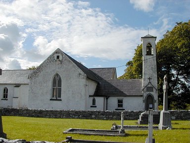
KINVARRA CHURCH
Map Reference: M362104
The little church near Kinvarra has a date stone 1845 above the door at the base of the belfry. It is a rectangular church
with a south transept and wooden framed Y-traceried windows. It is still in use. A cross on the west gable is dated 1819.
LACKAGH CASTLE
Map Reference: M418365
This castle is close to Lackagh Bridge.It appears to be about five storeys high with a vault over the third floor. A spiral
stairway rises in the north west corner and the south west corner is very damaged. A series of small rooms leading from the
stairway run along the west wall.
LYDACAN CASTLE
Map Reference: M438080
Lydacan Castle has a doorway which is round-headed on the outside and pointed
on the inside in a similar fashion to that at Newtown Castle. It is in the west wall. At the top of all four walls there are
corbels which carried some form of machicolation. To the left of the doorway is a small guard chamber and to the right is
a short passage, which leads to a spiral stairway, which rises to roof level. The gap between the two sections of the doorway
is accessible from the first floor and presumably serves the same function as a machicolation or a murder-hole. There is also
a fine murder-hole protecting the lobby. There is the usual pointed inner door leading from the lobby to the ground floor
room. This is a large rectangular room, which is lit by one small slit in the south wall. A slit in the opposite wall has
been partly blocked and a fireplace inserted in the wall. There is no chimney and the smoke exits via the remains of the slit.
There are good wicker marks in the vault. There is a second vault above the second floor and one storey above that. The narrow
western section of the castle has a vault above the ground floor, another above the second floor and another above the third
floor. Thus this part of the castle appears to have five levels and the main section has four levels. At the level below the
roof storey a passage runs between the larger and smaller sections to a latrine near the north west corner. The castle is
lit mainly by small single-light windows with a two-light window at the first floor. There are several cross-shaped loops
throughout the building. A small turret rises at the southwest corner.
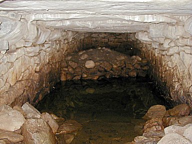
NASTIG FORT
Map Reference: M420060
Nastig Fort is about 30m across. It has a good substantial bank, which also contains
some stone. The entrance may be in the east and in the west there appears to be a small mural chamber. There is a large amount
of small stones lying within the fort. Some of this material may have lined the bank. Just off centre there is the entrance
to a souterrain. Only the outer section of this was explored on this occasion. From a previous visit it is known that this
souterrain contains a well and that the inner parts are not accessible.
NEWTOWN CASTLE
Map Reference: M423020
Newtown Castle, in Castle Quarter is a large round castle about three storeys high.
The doorway is in two sections with a round-headed outer doorway and a pointed inner doorway. The gap between the two doors
which was originally accessible from the first floor is now blocked. This was a defensive structure which performed the same
function as a machicolation or a murder-hole. This double doorway leads to a lobby with a guard chamber on the right and a
broad spiral stairway on the left. Ahead, through a pointed inner doorway, is a square ground floor room lit by narrow slits
within deep recesses. The castle is vaulted above the first floor which is lit by another narrow slit. This room has access
from the spiral stairway. Above the entrance area there is a long curving passage which is also accessed from the stairway.
The stairway is fragmentary beyond this level. The entrance is in the east and at the SW there is an exit for a latrine chute.
Presumably this latrine starts from above the vault. The castle is almost covered with ivy, which masks any window details
which may be above the vault.
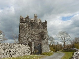
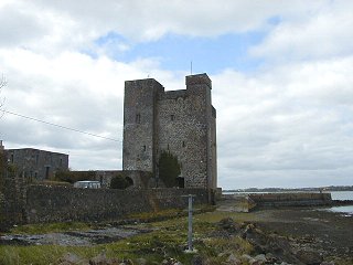
ORANMORE CASTLE
Map Reference: M377246
This is a 15th/16th century Clanrickard Burke tower-house. It was inhabited until the 1850s and then abandoned. It was restored
in 1947 and is still lived in.
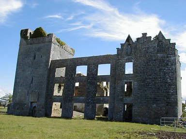
PORTUMNA FRIARY
Map Reference: M853040
The Cistercians of Dunbrody established a chapel at Portumna dedicated to Saints Peter and Paul. When it was abandoned the
Dominicans erected a friary dedicated to the Virgin Mary. The remains include a church with a nave, chancel and transepts
as well as some domestic buildings. There are some fine windows and part of the cloister has been re-erected.
ROSCAM MONASTIC SITE
Map Reference: M343242
At Roscam there is the stump of a Round Tower with a square-headed doorway. It
now has three storeys plus basement and is about 10m high. Close to it is the poor ruin of a church. A little further off
is a graveyard with a fine bullaun stone with a large bullaun about 40cm diameter and a smaller bullaun. Beside it is another
bullaun stone set on edge. It has three large bullauns. St Odran, son of Beoad and brother of St Ciaran of Clonmacnoise is
associated with the early monastery at Roscam. The site was devastated by Norsemen in 807 but little else is known about its
history.
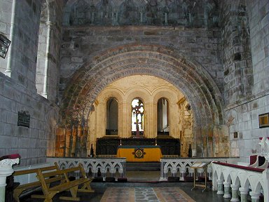
TUAM CATHEDRAL
Map Reference: M438520
In Tuam Cathedral there is a magnificent 12th century Romanesque chancel arch.
It has five orders and is richly decorated. The decoration includes the usual diamonds, chevrons, triangles and beading as
well as floral panels, but none of the masks as seen at Dysert O Dea or Killaloe. The capitals of the pillars have human masks
with intertwined beards and hair. The arch has a sixth outer order, which is narrower than the rest and does not have supporting
pillars. It looks like a decorated hood mould. Also in the church is the shaft of a high cross. It is richly decorated with
interlaced panels and intertwined beasts. There are inscriptions on both the narrow faces. On the opposite side of the church
the Market Cross from Tuam has been re-erected. This appears very tall and is a composite of two crosses. The head is much
too small for the shaft. The ringed head depicts a Crucifixion on one side. On the other side is an abbot with other figures
and there are two unidentified figures on the ends of the arms. The shaft is decorated with interlaced panels and intertwined
beasts. The pyramidal base has two figures on either side and at the narrow ends there are two round sockets for an unknown
attachment. St Jarlath founded a monastery at Tuam in the late 5th century. In the late 12th century a Romanesque nave-and-chancel
church was built and the chancel was incorporated into the Cathedral early in the 14th century. For many years it served as
a porch. The main part of the Cathedral is a 19th century building.
|