Gerhard Roux in Paraguay - Facts

| Mining and Manufacturing | The Chaco |
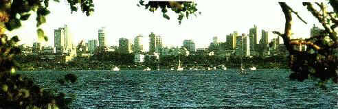
Asunción Skyline
ASUNCIÓN
Founded on August 15, 1537, Dia de la Asuncion, the beautiful Paraguayan capital still
retains much of the distinctive aura of its early days. This is easily perceived in its
solid buildings, streets and plazas of strong colonial workmanship resulting in the urban
design of a city full of trees and flowers, peaceful avenues and gardens along the banks
of the Paraguay River.
Along Mariscal Lopez Avenue, the city exhibits lavish mansions; and approaching the river,
there are picturesque dwellings in a modest neighborhood.
The Casa de la Independencia, built in 1772, rises at the very center of the city. It is,
perhaps, the oldest building in the country to open its doors today, as a museum. It was
the meeting place of the Paraguayan independence leaders; they departed from there to
undertake the siege of enemy headquarters. The result of that action was the surrender of
the last Spanish governor. In Colonial days, Asuncion was a place where European travelers
would stop to rest and get supplies as they reached the Rio de la Plata, attracted by the
gold and silver in Alto Peru. Presently, the city is an expanding metropolis with shopping
centers of all kinds and a population approaching a million.
Built on gentle slopes, Asuncion's unique beauty can be better appreciated by taking one
the electric trolleys that traverse the city. These tramways were originally pulled by
horses when service began in 1872. Still an active means of transportation, they add
another picturesque touch to the capital city.
Among the most interesting sights for the tourist are the port, the Cathedral, and the
Palacio de Gobierno - built around the middle of the last century and the present
headquarters of the Presidency. Also worthy of the visitor's interest are the Jardin
Botanico (Botanical Garden), the Central Railroad Station, The Avenida Costanera (Coastal
Avenue); Iglesia de Trinidad (Trinity Church) and various museums such as: Bellas Artes,
Historico Militar, Etnografico y de Arte Moderno (Ethnographic and Modern Art). The Casa
de la Independencia, located at 14 de Mayo St. and intersecting with Presidente Franco
St., is today a museum holding great treasures of the nation's history. The wonderful
colonial churches, Iglesia de la Recoleta and Iglesia de la Encarnacion, are also worth a
visit, as are the Casa Viola and the Panteon de los Heroes - built in 1863 as an oratory
to Nuestra Seńora de la Asuncion and where the country's heroes of independence are
buried.
Outside the city, visitors may enjoy a visit to the Pettirosi area, site of the well-known
market, Mercado 4, featuring agricultural products and national crafts. Or one can climb
up the hill known as Cerro Lambare, which provides a breathtaking view of the city.
Go to Top
PARAGUAY - General
Information
Area: 406,752 Km2
Population: 4.9 millones (1995)
Population growth: 3.9% (1995)
Population density: 11.7 habitantes Km2 (1995)
Languages: Spanish and Guaraní
Religión: Predominantly Catholic, religious freedom is allowed
Currency: Guaraní (G.)
Time: -4 hrs GMT Go
to Top
PRINCIPAL CITIES
The chief cities of Paraguay include Asunción , the capital and a commercial city and
port; Encarnacion , a railroad and agricultural center; Concepcion , a river port; Coronel
Oviedo ; Caaguazú ; and Ciudad del Este.
Most of the country's social and economic activity takes place in the eastern region.
Ciudad del Este is among its most thriving urban centers. It is the capital of the Alto
Parana district, and besides its great tourist and commercial activity, the city's
surroundings feature such attractions as the Club de Golf, Itaipu dam and Salto Monday.
Villa Florida, located on the left bank of the Tebicuary River, in the Misiones district,
is a favorite summer resort, featuring quality hotels and places for camping and fishing.
San Bernardino , a picturesque city founded by Germans settlers, 25 miles (40 km.) from
Asuncion on the shores of Lake Ypacarai, is very popular among national and foreign
tourists. Traveling on Route 2, visitors arrive in Caacupe, 34 miles ( 54.4 km.) from the
capital city. Every year, on December 8, thousands of fervent believers converge on the
city to gather in prayer before the Immaculate Virgin and take part in religious and
secular celebrations. This became one of the country's most traditional festivals. Near
the International Airport, and only 9 miles (14.5 km.) away from Asuncion, is the
community of Luque, founded in 1635, t iis renowned for the artistry of its goldsmiths.
They produce gold and silver adorned "mate" gourds and gold and silver handles
for walking canes. Some of these feature filigree in Spanish and Moorish styles. Luque,
and other neighboring communities, are known for their craftsmanship of musical
instruments, specially harps and guitars. The city of Encarnacion, capital of the Itapua
district and known as the "Pearl of the South" connects with the Roque Gonzalez
de Santa Cruz Bridge. Located along the Parana River, this city enjoys great financial and
commercial activity, as well as a good tourism infrastructure. It is also the point of
departure on the way to Trinidad, site of the impressive ruins of the Jesuit Missions, a
distance of 17 miles ( 27.2 km.) away. Go to Top
In 1767, Carlos III, King of Spain, expelled all Jesuit missionaries from Paraguay,
putting an end to one of the most daring social experiments to be carried out during the
colonization of the New World. For more than a century and a half, Jesuit priests had
organized an extraordinary network of missionary communities throughout the country, which
reached a high degree of development and importance.
In 1609, as soon as they arrived in Paraguay, the missionaries from the order of the
Company of Jesus founded the first of these communities - self sufficient within native
areas- and they set out to create a written vocabulary for the indigenous tongue, Guarani.
In addition to this, they established a new cultural, social and political order that
would exert considerable influence in the country's development. Every mission would
incorporate several hundred natives who, up until then, had led a nomadic life. The
missions implemented a new lifestyle and forms of Labour which enabled these native
dwellers to survive on their own, produce enough food, share their earnings and create an
efficient sanitary system. A portion of the production was sent to the Spanish Crown,
another was allocated for commerce, with a portion separated to cover the needs of the
communities and the rest was used by the native peoples.
A total of 30 such missions were founded throughout territories that today are part of
Paraguay, Argentina and Brazil. The Paraguayan ruins are the most famous, with Jesus, San
Cosme, Damian and Trinidad being the most important ones from an urban architectural
viewpoint.
When the Jesuits left the country, they left their monumental work behind, and these stone
ruins are witnesses to this eloquent time period. They are full of religious and artistic
treasures, and are forever silent, but have nonetheless left behind a priceless cultural
legacy which will last for an eternity. The architecture of the Missions combined European
and native elements, in style related to the Baroque: this fusion has come to be described
as " Hispanic Guarani Baroque" and it is perhaps most representative in the
Trinidad Missions, which features beautiful stone arches and murals. Of all the
Paraguayan Missions, it is the largest and the best preserved. It is only 20 minutes by
highway from Encarnacion.
Located approximately seven miles form Trinidad, is the Mission known as Jesus. For two
years, 3,000 natives worked in the construction of the church, which was left uncompleted
when the Jesuits were expelled. There are a total of seven missions in Paraguayan
territory, and in the last few years the government, along with private enterprises
(especially German and Spanish organizations), have made great efforts to rescue them as
bulwarks of Paraguay's culture and as relevant tourist sites. Go to Top
![]()
GEOGRAPHY
The Paraguayan territory covers a area of 157,046 square miles (406,752 Km2). It borders
with Argentina on the south and southwest, with Bolivia on the north and northwest, and
with Brazil on the northeast and east. Paraguay is divided into two distinct natural
regions: The Eastern region, covering 40 percent of the country's total expanse and
comprising all of the national watershed systems, along with the mountain ranges of
Amambay, Mbaracayu and Caaguazu. Cerro San Rafael, Paraguay's highest peak (2,788 feet/915
m.), can be found in this region. Also found in this region art the large rivers Paraguay
and Parana, the Ypacarai and Ypoa lakes, and Itaipu, the world's largest hydroelectric dam
found on the Parana River; as well as the capital city, Asuncion. It is also the major
center of economic activity. The Western region - or Chaco - irrigated by the rivers
Paraguay and Pilcomayo, represents the country's natural wealth: fertile lands for cattle
raising, agriculture and the lumber industry. It is an area of largely unexplored
territorial expanses. Its ecosystems are almost intact. Go to Top
POPULATION
According to data estimated in 1996 Paraguay has a population of 4,900,000. About 98
percent of the population is concentrated in the Eastern region, about 51 percent live in
rural areas and the remaining 49 percent in urban areas. The capital city of Asuncion, has
a population of approximately 950,000. Go to Top
It is located in the Cordillera district and unites two cities: San Bernardino and Aregua.
An internationally famous song was inspired by its beauty: Recuerdos de Ypacarai (Memories
of Ypacarai). The lake was formed by the waters of several brooks that flow into the Rio
Salado (Salt River), a tributary of the Paraguay River. It has a navigable surface of 35
square miles (90 km2), and 14 miles (23 km.) in length. According to legend, it was formed
in 1603, when the missionary Luis de Bolanos, exorcized the waters that were flooding the
Pirayu valleys. The name " Ypacarai" means " the waters that stopped
flowing upon being blessed". Go to Top
There are two official languages in the country: Spanish and Guarani. Most Paraguayans
either speak or understand both languages, although Guarani, the indigenous language,
predominates in rural areas. English, and Portuguese are spoken in the main tourist
centers and establishments. Go to
Top
Itaipu, conceived as the world's most powerful hydroelectric dam, has become one of the
greatest tourist attractions in South America, and viewing it from afar is not be enough
to grasp its vastness and complexity. Created by virtue of a joint agreement signed in
1973 between Paraguay and Brazil, its potential is colossal and it is projected that this
gigantic dam will increase its generating capacity as demand for electric power increases
in both nations.
The main dam wall of the Itaipu complex is six miles long (10kms), with a height
equivalent to 57 stories. Building the dam contributed to the formation of an artificial
lake that extends more than 120 miles (200 km2), providing more attractions to its
visitors. Three different tours of the dam are available, including one by helicopter and
one by hydroplane. The tours include a visit to a nearby Guarani village and museum,
including explanations on the characteristics of this fabulous piece of engineering.
Go to Top
CLIMATE
The climate of Paraguay is subtropical. At Asunción mean temperatures range from about
17° C (about 63° F) in July to about 35° C (about 95° F) in January. In July the
temperature can sometimes drop as low as 5ş C. In the Chaco and other points to the north
temperatures often reach 38° C (100° F). Annual rainfall averages some 1120 mm (some 44
in) in the Asunción area, some 815 mm (some 32 in) in the Gran Chaco, and some 1525 mm
(some 60 in) in the eastern forest regions. The Chaco has heavy rainfall in the summer and
almost no rain in the winter. Go
to Top
AGRICULTURE
The principal industry of Paraguay is farming. In the late 1980s the annual yields of
leading agricultural products, in metric tons, were cassava (3.9 million), seed cotton
(537,000), sugarcane (3.4 million), corn (1.2 million), soybeans (1.4 million), sweet
potatoes (113,000), bananas (420,000), oranges (360,000), and wheat (320,000). Livestock
breeding is a major agricultural occupation; Paraguay has approximately 7.8 million
cattle, 328,000 horses, 430,000 sheep, and 2.1 million pigs. Go
to Top
Forestry and Fishing
Forestry is very important to the economy of Paraguay. In the late 1980s about 8.2 million
cu m (about 290 million cu ft) of timber were cut yearly. Other forest products include
tannin and petitgrain oil, which is a perfume base. Fishing is negligible, the annual
catch being some 13,000 metric tons. Go to Top
PARKS PLANTS and ANIMALS
The plants and animals of Paraguay are substantially those of neighboring South American
countries. Paraguay proper, where rainfall is heavy, is covered by dense evergreen forests
interspersed with a wide variety of tropical grasses, ferns, palms, and exotic flowers. In
the Gran Chaco, vegetation is comparatively sparse but includes the red quebracho tree, a
rich source of tannin extract. The plains are covered by coarse tropical reeds, grasses,
and stunted trees.
The animals of Paraguay include armadillo, capybara (a large rodent), tapir, jaguar,
anteater, wild boar, deer, alligator, and various species of snake. Among the local birds
are toucan, ibis, heron, parrot, black duck, dove, partridge, American ostrich, rhea, and
parakeet. Many of these birds exhibit strikingly beautiful plumage.
Go to Top
Parks and Ecological Reserves
In Paraguay there are eight national parks which underscore the country's interest in
ecological preservation. They cover a area of about 11,583 square miles 30,000 (km2). Five
of these parks are located in the Eastern region: Caaguazu, Ybyturuzu, Ypacarai, Ybycui
and Cerro Cora. The other three are located in the area of El Chaco: Tifunque, Tte. Enciso
and Defensores del Chaco.
Besides the parks, there are eight other areas dedicated to the preservation of flora and
fauna: a scientific monument, Moises Bertoni; a national reserve, Kuri'y; two biological
reserves, Itabo an Limoy; one biological refuge, Tati Yupi; and Mbaracayu, a natural
forest reserve.
As evidence of Paraguay's ecological wealth, in its territory there are between 600 to 700
species of birds, mores than 200 species of mammals, some 100 species of snakes and
reptiles, 60 kinds of amphibians an 8,000 different types of flora. Some active programs
are oriented to protect endangered species such as the Tagua Project, dedicated to the
preservation of an endangered bird, the coot and in charge of its propagation. Coots were
believed to be extinct, but fortunately some specimens were discovered in 1973.
By law, hunting, as well as trade, export and import of goods and/or products of all wild
fauna that temporarily or permanently inhabit the country is illegal. Thanks to the
national authorities' protection of the fauna and flora, this country has become a
valuable destination for ecotourism.
Paraguay's jungles, plains and forests have a rich diversity of animal species, such as
primates, deer, peccaries, armadillos, anteaters, jaguars, pumas, and birds like the
ńandú or South American ostrich; the pajaro campana, sparrow hawks, parrots and geese.
Reptiles such as lizards, iguanas, snakes (some of them poisonous), turtles and crocodiles
can also be found throughout its territory. Go to Top
MINING and MANUFACTURING
Mining is unimportant in Paraguay. Although deposits of petroleum, iron, manganese, salt,
and other minerals are reported, they are not exploited commercially. Limestone, extracted
in significant amounts, was used in producing about 269,200 metric tons of cement annually
in the late 1980s.
Manufacturing is confined largely to agricultural and forestry products and to basic
consumer goods. Among the important products are packed meat and other foodstuffs,
textiles, wood products, and chemicals. Go to Top
THE CHACO
It is the largest region in the country, and is also the least populated. It covers a area
of 95,337 square miles (244,00 km2) , about 61 percent of the whole Paraguayan territory.
However, it is inhabited by only a little more than 2 percent of the nations's population.
Nonetheless, the peculiar landscape of El Chaco and its exclusive fauna and flora make it
uniquely interesting to tourists.
The Chaco can be reached by boat or highway on the Trans-Chaco route. Nature lovers can
enjoy excursions and ride or horseback through almost unexplored areas, both in Alto
Chaco, where rainfall is minimal, and in Bajo Chaco, an area of big swamps and forests of
quebracho and palo santo (holy wood).
There are more than 500 kinds of hardwood trees in this region, and approximately 300
types of medicinal plants, including such unusual varieties as cactus and
"sumu'u" a big-bellied tree. Many different birds can be seen in this region,
such as the South American ostrich, and also wild beasts like jaguars, ocelots, brown
wolves, waterhogs (carpincho), pumas and others. Go to Top
 Home
Home