Chino Hills State Park
State of California, Department of Parks and Recreation
General Info: (909) 780-6222, Park Dispatch (909) 940-5661
Riverside County, California
By Carl Morrison (Morrison_c@www.auhsd.k12.ca.us)
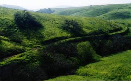
Chino Hills State Park offers 13,000 acres of wilderness area and has over 65 miles of trails. Day use fees, from 8 a.m. to sunset, $0 for hikers, bikers, and horse riders. Vehicles are $5.00.
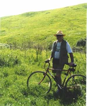
| March 15, 1998 at 12:45 pm. Daughter Carla drove me and my bike 22 miles east of our home in Placentia, CA, to the Main Entrance to Chino Hills State Park. We drove about one mile up the one-lane gravel road from the street until we reached the Fee Collection Kiosk. At this point we were already at the top of Bane Canyon between two ranges, Bane Ridge on the west, of hills and could see no sign of habitation less the green California State Parks pickup and the 4 by 8 'kiosk' manned by a solitary black lady in the requisite uniform. She gave me a Trails Map and said they had been working on the Telegraph Canyon Trail, but it wasn't completely repaired yet. I said it was my intent to ride that the Telegraph Canyon Trail to the western terminus of the park, some 13 or 14 miles. She said, "Be careful, and enjoy the day." Carla took my picture and I waved bye. | |
|
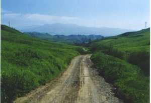
I started coasting down the gravel road from the Kiosk...it
would be downhill for about 2 miles as I recalled from my previous ride through
the park.
12:53 Hills rose on both sides of me, the lone rider on the gravel road, and the only sounds were birds chirping. It was about 70 degrees with a gentle breeze in my face. A creek ran alongside the road. Clean water was seeping out of the sodded hills and flowing in the creek, one reminder of the 22 inches of winter, El Nino, rain storms we had in this 1998 winter. |
|
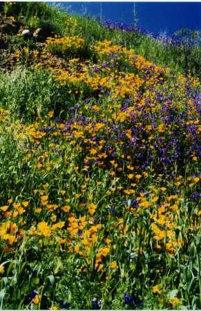
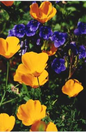
I stopped along the road, put my bike in the waist high weeds, clambered down the embankment, jumped the creek, landed on the soft bank on the other side, and began a 100 yd. walk up to some orange and purple flowers I'd seen on the south facing side of the hill. My walk was uphill where water had earlier rushed with great force down the steep grassy hills. Mud had been deposited on top of the grasses, but they were working their way up through the mud. Coyote or dog tracks first caught my eye, followed by deer tracks before I got to the flowers. I discovered the orange flowers were California Poppies, the taller version than you find in windier areas like the California Poppy Reserve in Lancaster, California. The purple flowers among the poppies I could not identify. |

|
1:20 Back on my bike, the only sounds were of birds and an occasional private plane overhead. What looked like cotton seeds in the air were from the willows growing along the creek. Near one culvert where water pooled and a hollowed-out-by-fire Sycamore still grew, two squirrels crossed the gravel road ahead of me and found refuge in the hollow sycamore.
More easy downhill coasting, past the where Slaughter Canyon came in from the left, I came to the overlook trail up and to the east. I started pushing my bike up the runoff water rutted work road, but soon retreated remembering Carla having told me, when she dropped me for the ride, "You only have 5 hours, Dad, until sunset. Remember how we didn't get out until after dark last time?"
| Asphalt pavement soon replaced the gravel road and rose
up and to the right as natural creek continued on south toward the end of
the park at Scully Hill to my left, some 6 miles south. I reached a high
parking area surrounded by a low wooden rail fence. I could see far to the
south, down Lower Aliso Trail across the green hills and scrub trees. Water
that flowed through this valley, away from me, eventually reached the Santa
Ana River. I began to realize what "watershed" meant. The term I'd learned
in my youth in agriculture classes back in flatland Indiana, and I could
see how the Santa Ana River quickly had flood like currents after what seemed
like a small amount of rain. All the tributaries in the13,000 acres on this
north side plus an equal amount of land on the south side of the usually
dry river could amount to a lot of water in a short time.
|
 |
| The only other people in sight were right beside me at this
overlook...a lady with two young girls having a picnic. I wondered if they
had viewed the sign at this overlook with the same fear as I did! Couldn't
notice that the two rattlers were labeled in red..."Poisonous"
These 4 snakes were each more colorful than anything I'd come across making hay back in Indiana. We called those black snakes and blue racers and knew that in the rock hill faces were poisonous copperheads and in the rivers poisonous water mocassins, so the ratio was about the same and I'd lived this long without snakebite, I didn't give it further thought. |
| My thoughts were diverted from the 'Snakes of the Scrubland"
sign by a metallic 'squeak, squeak, squeak...' . I walked to the northwest
part of the overlook and spied a windmill down in the gulley below me, with
propellar spinning. The tail on the apparatus always kept the blades into
the wind and the long shaft down through the tower to the well head kept
moving up and down constantly. In the past, cattle had learned that this
was the only place to get a twice-a-day drink when dryer months arrived in
the summer.
1:51 I coasted down from the overlook on the smooth blacktop and rode a few yards as the road passed large trees in a wider creekbed. The earlier rains had really rushed through this area as I saw brush left behind from the swirling waters, still wrapped around the tree trunks. A cement creek-crossing left to the right, north, to the original farm building from the ranch. I had stopped there on an earlier ride with Carla and saw that they had turned the farm house into a visitors center. A family of 5 were on the paved creek-crossing throwing some tree seeds into the clear, pooled water below 'making wishes.' I did not take the visitor's center cutoff, but rather looked for the familiar beginning to the Telegraph Canyon Trail. A gate was closed across the trail, which I had never seen closed before, but bikes could legally skirt the closed gate and continue. It began steeply so I pushed my bike up the untraveled gravel road until 2:00. |
 |
I knew what was ahead from our earlier, summer, ride on this same trail. It had been much hotter and dryer and I can remember seeing DEAD teranchulas in the dry sunbaked roadbed. Not likely today. A cool on-shore breeze met me today, but hiking with a photo vest I still worked up a sweat. I knew of a hellish hill I had to climb soon, so water and a cookie were in order before I attempted this toughest part of the afternoon ride.
 |
2:50 As it turned out, there were TWO hellish hills instead
of the one I'd remembered. In describing the steepness of the road up these
hills, I can only think of climbing a step ladder while pushing my bike...not
a pretty sight. I turned back, at the summit of the second hill, for a 'been
there, done that' picture. I had started coming down the valley just this
side of the far range of hills, left of where the power lines crossed the
far crest of the hills.
I soon saw why the gate had been closed to vehicle traffic...first a wash-over of mud and silt from one side of the road. It was so deep that I could see where a vehicle had gotten stuck less than 1/3 of the way across the silt flow. It had dried enough since that horses hoofs sank only about 3 inches and bikes and people had walked across without sinking in at all. |
Across the road not much farther, in another steep section, was a horizontal cut across the road that could only be called a fault...more than knee deep and 3 feet wide running down the embankment on the right side of the road, across the road, and on through the shrubs to the left side of the road...cur across as clean as a whistle and the roadbed had just dropped 3 feet down. Since it was on an uphill part of the road, you could walk into the fault by stepping down about 8 inches, across the 3 foot wide fault, then a hefty step to get out the other side. I biggest question in my mind was, "Whose fault was it?" I concluded that it might have been a collapsed underground pipeline, but, boy, what a big pipe it must have been. I lifted my bike across and peddled on up the hill then stopped. As I looked back, I could not see the 3 ft. dropoff from the uphill side at all...boy what a surprise for the next bike rider going east. I presume a horse would have enough horse sense to stop early of stepping into the fault regardless of the riders awareness of the dropoff. I'd not seen a single person since my taking this closed trail over an hour ago. I planned to warn anyone going east about the fault, but didn't see anyone else for another half hour and they were all using the western side of the summit.
| After 3:15, I reached the summit. The 'park divide' if you
will, where it would be all downhill to the western terminus of the park,
some eight more miles. I treated myself to more water and cookies and put
my vest back on since the breeze over the top of the hills was cooler and
a little stronger than when I climbed the east side to get to the summit.
While stopped, I heard a lone coyote or fox barking on my left side, but
when I crossed the summit and started down the west side, I heard an answering
bark to the right. I reminded myself to bring small binoculars for hawk watching
next time...I was beginning to catch my breath and concluded there probably
would be a next time now!
The grass has been as high as my waist in places, right in the roadway, since there hadn't been vehicles for quite a while. I remembered those 4 kinds of snakes as I pushed my bike through the tall grass! In some places the trail was void of grass, but where silt had washed out on the road, with seeds embedded, there was hardly a trail. |
 |

Looking west, I could see it was downhill the rest of the way. The first humans I'd seen in over an hour were at the end of the visible part of the trail, to the right. A crow, or raven, left its companions in the trees along the trail below and climbed the upward-flowing breeze to swoop above and away from me, making several lazy circles. |
Since I was coasting downhill nearly every foot by now, I didn't stop to take notes, just occasionally to take a photo. Once I rounded a corner in the trail to see a Br'er Rabbit cross my path, then stop, with the afternoon light showing behind his ears, to check out the strange creature focusing his 'eye' on him while straddling his two wheels. If he'd had a camera he surely would have taken MY picture to show to the guys backin the den and laugh together.
| Not much farther I reached the expected Cattail pond. Carla and I had watched red-winged blackbirds here on our last ride. A bicyclist zoomed by and no birds arose from the pond like last time. I waited quietly and soon chirps and answer chirps could be heard...then birds came from within the rushes up on the tops of the reeds...then more and more, only showing the red when they flew, otherwise they were black and practically invisible, especially to fast traveling park visitors. I enjoyed the activities of the bird community. |
|
|
The other windmill was closer to the trail and had a trough for horses. The tail of the windmill had the traditional 'Aeromotor' trademark. It changed direction and speed more than I thought it would have since the afternoon breezes were swirling through the arroyos and California Oaks on this west facing side of the hills. More bikers were enjoying this side of the park, as well as joggers, and horseback riders. I got to the western edge of the park about 4:15...13 miles and 3 1/2 hours from my being dropped off at the eastern entrance. What a great day in the country, and only 15 more minutes of riding on Carbon Canyon Hwy. and Valencia Street and I'd be home in the suburbs. The trail ends in a large orange grove and those who know of this secret entrance can make their way through the grove to Carbon Canyon Regional Park then out on the highway. |
It was a good feeling reaching home at 4:30 in the afternoon. I felt like I'd been "Back Home Again in Indiana" where I used to take walks along the B & O Railroad at Hayden, Indiana, and see wildlife similar to what I'd seen today some 2,000 miles west of those early days.
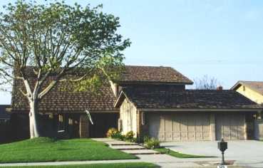
The swing in the front yard seemed more inviting than usual, so I stored my bike and spent some time swingin' and dreamin' about what a great place Chino Hills State Park is and how much I still liked the countryside
where the green grass grows,
the coyote and deer still roam,
and it's all not far from what I call home.