 readable 32k version of map -- unwieldy 152k version of map
 [This exposition appeared in the October, 1997, Hour Glass, vol. 5, #10. © 1997 Historical Society of Ogden Dunes, Indiana, Inc.]
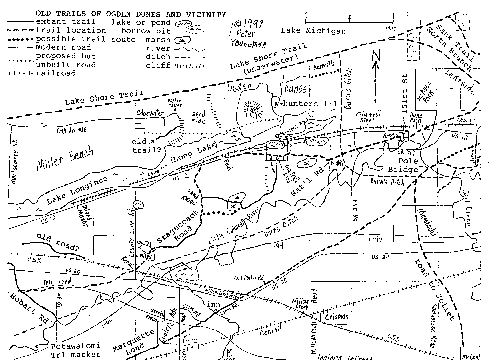
There were undoubtedly trails traversing Ogden Dunes before Mackenzie laid out our roads but they were obliterated long ago and, if there are any records of where they ran, I am unaware of them. George Dalby recalls an old hunters' trail from his childhood. It is still visible cut into the side of the hill west of and parallel to Cedar Trail 1/3 of the way from Ogden Road to the Ledge. I do not understand why it is where it is, as it does not seem to follow the rules of path creation. When I first noticed it, I assumed it was a filled-in utility trench but was wrong.
The appellation Reck or Mackenzie hung on The Ledge suggest to me that foot traffic had already beaten a little shelf into the side of the hill above Sleepy Hollow before the modern road was improved. I do not see the developers commemorating a "ledge" they made themselves.
Ogden Road between its east end and Juniper Grove follows a nice, fairly flat route, sheltered from winds off Lake Michigan. It makes sense as part of an old east-west trail. Continuing along the same route east across Rupert's to Burns Ditch presents no great obstacles. Heading west however, a steep, unbroken ridge stands beyond Cedar Trail. Before the last couple houses were built there, several paths climbed over between Cedar and Beach Lane but none of them appeared as gentle or worn as a popular old trail would have.
Before Chrismar was developed, a path led west from Diana Road, between Ski-Hill and Summit Roads. It had surely been shaped by modern explorers though, not ancient ones.
Over in Edgewater, a roadway, which is now slowly being covered up by Smoking Dune, extended eastward off Oak Avenue. It curves sharply to the south and ends at the sandmined cliff. Was that simply a road to the former water tower, with a jeep-trail running off it for access to the uncivilized area? (Before the N.P.S. took over, that was a playground for jeeps.) Or did a road continue farther east before being sandmined away? My guess would be the former. Unfortunately Inland Steel's sandmining did obliterate any clues to the area between Ogden Dunes and Vineland (Edgewater.) That area's topography was not even mapped until after it was sandmined.
There is another pathway which heads west from the cliff-face and long-preceded the national park, where it is now one of their trails. Although jeeps could have reached parts of it, I do not interpret it as simply a fun jeep-trail. While ORV use can simulate many years of foot traffic, this trail appears to me to be plenty old. As that area of the Indiana Dunes was never as popular with day-trippers as farther west in Miller and farther east in (the real) Dune Park (Wilson) and Waverly Beach, I would think that it even predated the dunes visitors of a century ago.
Return to top of page.
Return to main Hour Glass newsletter page.
Return to Historical Society of Ogden Dunes home page.
George Brennan, in The Wonders of the Dunes, mentions a road from Michigan City following "on the inside of the Dunes through Dune Park, along the northern shore of Long Lake where the stage road divided. One road went over the Dunes a few miles, making a very pretty road still [in 1923] to be traced as a trail, that came out to the beach about a mile east of Miller, near the old Berry's Tavern of 1833, and then continued along the beach to Chicago.
"The branch road that became the Michigan City-Tolleston Road, followed an Indian trail along the Dunes through Miller, and along the Tolleston Ridge, passing through Tolleston and Hessville . . ."
His wording is not clear to me but he appears to be referring to Lake Longinus in its broader-than-usual sense, as the seven-mile stretch of Great Marsh between Lake Street and Shadyside. Long Lake was deeper before a ditch was dug from its west end to the Little Calumet River. The north arm of Burns Ditch lowered the water table even farther.
Hardesty's 1876 and Andreas' 1876 maps both show roads branching at Baileytown. Abbot's 1855 map has a different second road but veering off at the same place. Newcomb's large-scale 1871 map shows a trail heading west along the north side of Long Lake but ending in the middle of nowhere at the Lake County line. It would be nice to know where he got his information.
The topography of eastern Miller Beach suggests a couple ways such a trail could have cut away from Lake Longinus and hit Lake Michigan about at Montgomery Street but roads and houses undoubtedly have obliterated any traces of that trail now. I invite any hiker of that trail, which apparently at least existed 74 years ago, to expand on Brennan's description.
As he mentions the road dividing "along the northern shore of Long Lake," that reads as if the Tolleston Road also runs north of Lake Longinus. Surely what he was referring to however was what maps do show--the ancient trail north of the Little Calumet River, pieces of which still exist as today's Stagecoach and Hobart Roads and Miller Avenue.
All that means a trail apparently ran through Ogden Dunes along the north sides of Long Lake and the marsh which used to extend east. Parts of it would seem to have been where Diana, Hillcrest, and Boat Club Roads lie today but finding proof of that in developed Ogden Dunes is beyond the capability of current technology.
Return to top of page.
Return to main Hour Glass newsletter page.
Return to Historical Society of Ogden Dunes home page.
The Detroit-Fort Dearborn Road for awhile ran along our beach. That route is now out in Lake Michigan, as the Port has caused the shoreline here to move. In poor weather, pioneers would often travel along the south side of the first dune ridge. Stagecoaches and wagons could only do that where the terrain was right. This route has also been styled the Lake Shore Trail, the North Branch of the Great Sauk Trail, and the Pottawatomie Trail.
There are as many different Potawatomi Trails through Porter County as Chicago Roads though. Figuring out exactly what route writers have in mind is often impossible. All the roads to Chicago have also been referred to as Indians' Michigan Trails. I would have to resort to my imagination to determine where the LaSalle Trail and Little Sac Trail ran but that is just what many writers have done.
readable 32k version of map -- unwieldy 152k version of map
Ogden Dunes does not have the history of habitation that the State Park, Miller, and Wilson have. Those three locations were where old north-south trails reached the Lake. There was a way "across" greater Lake Longinus here during periods of low water. There was no particular reason for travelers to want to pass from the Stagecoach Road to Lake Michigan here however.
Duners in 1925 claimed that an old logging road had extended north from Stagecoach Road into our town since before 1870. That crossed the railroads about 400 feet east of Hillcrest Road. The grade still exists, curving northwestward from Conrail. Hillcrest joins it north of the police shanty. I do not know when the fill was added but it looks like a fancier raised roadway than mere loggers would have built. Any trace of it between the railroads is long gone. No mention of it extending farther north than Diana or Boat Club Road has been found.
There is a piece of a well-worn north-south trail east of town but I take it for a path to cottages in Rupert's Subdivision, perhaps used before the Gary Boat Club Road was built along Burns Ditch.
Return to top of page.
Return to main Hour Glass newsletter page.
Return to Historical Society of Ogden Dunes home page.
The road sitting along Ogden Dunes' southern boundary was presumably built to provide access for homes immediately south in Portage. It is named Stagecoach Road but no stagecoach ever rode over that stretch or the spur to U.S. 12. The ancient trail runs to the north of Dunes Electronics and east into the sandmine, "NO TRESPASSING . . . ALL VIOLATORS PROSECUTED." The road through the sandmine still pretty well follows the old route but it is not really in the same place. Where the stagecoaches ran is now up in the air.
This is what writers refer to as the Tolleston Beach or Dunes Trail. Those are simply modern names for this Chicago-Detroit Road of course. If Indians or explorers or pioneers had local names for the different stretches of these trails, those are lost to us.
West of Tittle's building, where today's street jogs south, the real stagecoach trail ran straight west. It is overgrown but I have no problem following it on foot along a shelf through the woods. It overlaps today's gravel road past the north side of Whelpley's house for a couple hundred feet. Then it curves south, crosses into Portage, and passes to the west of Dozier's.
Today's Stagecoach Road rejoins the old trail about 900 feet south of Ogden Dunes. That last stretch was clearly visible even several years ago but barricades to keep jeeps off it are causing it to fade away in the overgrowth. The Ogden Dunes portion of the trail was platted as the Old South Road but, except for the bit north of 60 Stagecoach Road, that has been vacated.
When Stagecoach Road was paved in the '70s, the level of the portion along the sandmine was dropped. Otherwise it pretty much follows the ancient path. 1.4 miles southwest of Ogden Dunes, where the Sand Knobs were mined away, the road has been straightened a bit. The ancient trail is not followed by a modern road west of Pershing Street in Harbor Oaks. It can be seen heading northeast off County Line Road just north of the CSX tracks. It ran between the two yellow posts.
Development has obliterated the stagecoach trail through Lake County. A little bit of an old blacktop road can be found southwest of that porno shop on U.S. 20. [The fence they put up sliced across it and has pretty well hidden it from 20. The more recent work back there may have eradicated it entirely.] I believe the tollroad wiped out the rest of it west to Hobart Road. The Detroit Road joined the road from Lake Station and curved northwest to Miller along that Hobart Road. [A gravel trail extends between that trailer park (Mansard du Lac?) on Hobart Rd. and Lake Street but I think that was just a sandmining road.]
Southwest of Inland Manor, a local resident pointed out a pathway that does look like an old trail rather than a modern jeep creation. I reject his notion that it was an important, ancient route however. I see it as simply a local road to Miller from Dock Siding/Calumet/Kerwin keeping north of the CSX tracks. Conflicting information from maps, histories, and observation has to be evaluated but the answers are never completely certain.
Back east of Ogden Dunes, the "National Road," as it was platted through Heath's Addition to East Chicago, crosses Burns Ditch where the high tension lines run today. The north arm of Burns Ditch of course did not exist until 1925. I have heard that the ancient trail was still visible east of Crisman Road before the so-called "Midwest Steel Highway" was built, though it was misinterpreted as the original grade of the New York Central Railroad. The South Shore crossed that stagecoach road about where S.R. 249 exits onto U.S. 12.
Return to top of page.
Return to main Hour Glass newsletter page.
Return to Historical Society of Ogden Dunes home page.
The third Detroit-Chicago Road in our area entered Portage Township about 3/10 mile south of U.S. 12, along a continuation of Shadyside Road. It has also been called the Calumet Beach Trail, the Inland Route, and the 1837 Post Road. It crossed the Little Calumet River over the Long or Pole or Old Log or whatever Bridge about 500 feet west of abandoned Samuelson Road, as mentioned in the August Hour Glass.
I have toured the Crisman sandmine but could find no trace of the ancient trail. Perhaps the roadway was sandmined but I think it had been northwest of that area. Perhaps the burying of the gas pipeline removed any signs. The stagecoach was rerouted through Crisman in the last century though, so perhaps that stretch of the road simply faded away.
S.R. 249 crosses the trail about where it crosses I-94. U.S. 20 joins it about 1/10 mile east of Willowcreek Road. I believe U.S. 20 was built along the south side of the old road but will not guarantee that some of 20 was not stuck on top of it.
When you exit 20 on Old Porter Road heading to Jellystone, you follow the ancient road for about 500 feet before turning north. A couple discontinuous pieces of it exist to the northeast, one as a driveway. The old sand road southwest from Marine Drive became part of the truck parking lot several years ago.
An old jeep-trail between the trucking firm and U.S. 20 approaches the CSX tracks at about the right spot and angle but I believe that the ancient route ran along the other side of the fence. Unfortunately I did not walk the area until recently so do not know about the "old sand road" except from maps.
Southwest of the CSX is a well-used ORV-trail in about the right location to be the old road. I think however that the Chicago Road intersected the railroad along an overgrown but discernable grade to the west of today's path. Farther south, there is evidence of an improved grade on the other side of the path. I may return to investigate further when the vegetation is down a bit.
South of 20, Clem Road follows the old trail. Where Clem curves away from the tollroad, the Chicago Road continued southwest for another 6/10 mile. West of Cooley's Addition to East Gary, Marquette Road starts following the old trail.
Return to top of page.
Return to main Hour Glass newsletter page.
Return to Historical Society of Ogden Dunes home page.
No matter what some goofballs have written, no part of the Dunes Highway in Portage Twp. follows any old trail. It was a brand-new (in 1923) road simply built along the south side of the South Shore Line. Late in the last century, a road was created branching west off the Stagecoach Road, where that curved south in South Ogden Dunes. It ran over to and along the south side of the New York Central tracks. After the South Shore Line was built, the road lay between the railways. All traces of it have been obliterated.
A road was also created which intersected with that one, where the N.P.S. recently paved a little roadside park. You can still follow the road by walking west from the southern marsh overlook platform along the old path a ways. When you reach a perpendicular dune ridge, take that south until you connect up with Stagecoach Road at the Sand Knobs.
I enjoy reading about local history but find that looking around and trying to reconcile written accounts with what I can see for myself today makes the whole subject much more fun.
Comments are welcomed by the author.
![[WEBMASTER E-MAIL]](https://members.tripod.com/~Ogden_Dunes/letter.gif) |
Hour Glass |
![[Historical Soc. of Ogden Dunes]](https://members.tripod.com/~Ogden_Dunes/home.gif) H.S.O.D. |
|
|---|
This page is at https://members.tripod.com/~Ogden_Dunes/newsltr/5/trails.html.