Paper Contact Information:
Kelly Edwards
(915) 687-7521
kaed@chevron.com
SPE 38910
* SPE Members
Copyright 1997, Society of Petroleum Engineers, Inc.
This paper was prepared for presentation at the 1997 SPE Annual Technical Conference and Exhibition held in San Antonio, Texas, 5-8 October 1997.
This paper was selected for presentation by an SPE Program Committee following review of information contained in an abstract submitted by the author(s). Contents of the paper, as presented, have not been reviewed by the Society of Petroleum Engineers and are subject to correction by the author(s). The material, as presented, does not necessarily reflect any position of the Society of Petroleum Engineers, its officers, or members. Papers presented at SPE meetings are subject to publication review by Editorial Committees of the Society of Petroleum Engineers. Electronic reproduction, distribution, or storage of any part of this paper for commercial purposes without the written consent of the Society of Petroleum Engineers is prohibited. Permission to reproduce in print is restricted to an abstract of not more than 300 words; illustrations may not be copied. The abstract must contain conspicuous acknowledgment of where and by whom the paper was presented. Write Librarian, SPE, P.O. Box 833836, Richardson, TX 75083-3836, U.S.A., fax 01-972-952-9435.
Abstract
A methodology was developed to model and successfully history match the primary and waterflood phases in a 15 well, 100 acre vuggy portion of a carbonate field in west Texas. This method is based on a derived log trace of secondary porosity calculated by subtracting sonic porosity (matrix only) from a core calibrated total porosity transformed from Density and Neutron-logs. Log signatures of vugular intervals were developed by recognizing significant differences in matrix and total porosity. A detailed geostatistical distribution of total porosity was first generated and permeability was assigned using a cloud transform of core data from nearby wells. Two geostatistical distributions of secondary porosity with different correlation lengths were then generated using the developed secondary porosity trace. Vugular zones were assumed to have a secondary porosity of 8% or greater. These models were superimposed on the permeability cube by assigning exceptional high permeability values to the vuggy zones.
Using a general scale up method, the detailed permeability cubes were scaled-up for simulation studies.
The models incorporating vuggy permeability distributions showed a far superior history match of primary and waterflood performance than those without vuggy permeability distributions. Good history match was also obtained on individual well basis. Sensitivity of the match to vuggy zone permeability and correlation length was analyzed. Results from these simulation runs provides insight into the spatial distribution and permeabilities of the vuggy zones.
Introduction
Dissolution is one of the major diagenetic processes adding porosity in carbonate reservoirs. Vugs in carbonate reservoirs are the result of carbonate dissolution, evaporite (gypsum or anhydrite) dissolution, or some combination of both. Routine core measurements for porosity and permeability are problematic for characterizing vuggy zones in these reservoirs because (1) plug type samples are generally chosen from intact core and therefore generally away from vuggy zones, and (2) whole core samples are not often sampled systematically with vuggy zones in mind. When building models, the distribution of porosity is usually obtained from log data. This data is considered fairly accurate. However, permeability distributions will be skewed to the low end because the porosity to permeability transform developed from core plug measurements does not honor reservoir-scale vuggy-interval permeabilities.
Flow in high conductivity vuggy intervals is the dominating factor affecting the overall displacement efficiency in any secondary recovery process of a vugular carbonate reservoir. Honoring the permeability and distribution of secondary porosity features in reservoir characterization is crucial for a successful prediction of recovery for this type of reservoir.
The objective of this study was to develop a methodology for reservoir characterization and modeling of a waterflood in a vugular carbonate reservoir setting. The reservoir selected for this study was the McElroy Field; one of the Permian basin carbonate reservoirs with a complex diagenetic overprint and a long history of waterflood.
Field History and Geology
The McElroy Field, which is one of the larger fields in the U. S. Permian Basin, is part of a major productive trend lying along the eastern edge of the Central Basin Platform (Figure 1).1,2 The field was discovered in 1926 during the initial exploration along the Central Basin Platform and is located in Crane and Upton Counties, Texas. The reservoir is a stratigraphic-structural trap with oil production coming primarily from heterogeneous dolomites of the Grayburg Formation. The Chevron-operated portion of the McElroy field, encompassing about 22,400 acres, has a cumulative production of 380 million barrels of oil (MMBO), of an estimated 2.2 billion barrels of oil (BBO) in place. It currently produces approximately 17,000 barrels of oil per day (BOPD) from a mature waterflood. Development started in what is now the central portion of the field, called the Low Pressure Area (LPA)(Figure 1). Field expansion and subsequent development started in 1930 and proceeded in several stages. Waterflood pilots began in 1947, but field-wide waterflood development was delayed until the early 1960s.
Core studies in McElroy show the Grayburg carbonate shelf deposits to be anhydritic dolostones that become increasingly evaporitic and silty toward the top of the Grayburg formation and into the overlying Queen formation (Figure 2).3 Terrigenous sediments and evaporites of the lower Queen formation provide a cap and seal for the Grayburg reservoir rocks. The overall depositional succession within the Grayburg is a series of upward shallowing and generally eastwardly prograding carbonate units. The lower Grayburg represents more open ramp environments, the central Grayburg reservoir zone represents shallower ramp environments, and the upper Grayburg represents nearly intertidal environments..
The main pay interval of the Grayburg is primarily peloidal dolograinstones and packstones, and its porosity is mostly interparticle and intercrystalline. The field has a heavy diagenetic overprint which masks much of the stratigraphic nature of the field. Dissolution has increased the porosity in some areas by adding moldic and vuggy porosities, while in other areas interparticle evaporite cements, i.e. gypsum and anhydrite, have reduced the porosity. Porosity, permeability, and, consequently, reservoir quality generally increase from west to east across the field. However, this west-to-east increase in reservoir quality masks the extreme local variability of the reservoir and the significant lack of spatial correlation between porosity and permeability.4,5
Vuggy Zones
Logs, cores, CT scans, and production history indicate that thin zones of high porosity and high permeability occur within the main pay interval of the LPA and strongly suggest that these zones are the product of secondary porosity development, i.e. vuggy porosity, in the carbonates. The effect of these zones is especially noticeable on production performance, which is characterized by early water breakthough, water cycling, and high production and injection rates. The properties of the vuggy zones, however, such as permeability (relating to how well vugs are connected) and spatial distribution are not well understood. Thus, a major objective of this study was to develop a reasonable method of characterizing the vuggy zones in simulation models.
X-ray computed tomography (CT) scanning and geostatistics have been used to better understand the properties of the vuggy zones. CT scans of the whole core samples more clearly indicate the distribution of vugs within core samples (Figure 3), as CT scans allow for three-dimensional image reconstruction to analyze a volume and visualize the degree of carbonate vug connectivity. Large and small vugs occur within the scanned samples; more importantly, the scans show low density halos around the vugs which we interpret to be zones of slightly enhanced matrix porosity (Figure 3B). This suggests that the vugs are becoming connected to some degree through their halos. Using an air mini permeameter to measure permeability distribution around the vugs, showed values as high as 700 mD close to halos around the vugs. These measurements showed lower values (~100 to 200 mD) for the regions of the core further away from the vugs. Brine permeability tests on these cores show Darcy range permeabilities.
Porosity logs (sonic, bulk density, and CNL porosity) characteristically show significant variations in porosity and the presence of thin highly porous intervals, but log correlations of the high-porosity zones from well to well are generally ambiguous. Geostatistics provides a means to develop spatial models of the vuggy zones, which can then be evaluated in simulation models.
Model Development
Geostatistical Models:
The selected area of study consists of 100 acres located in parts of sections 197 and 198 of the low pressure area. Figure 1 shows the area of study relative to the LPA and the entire outline of the field. The following methodology was used in constructing the detailed (106 x 100 x 100 cells) geological models:
Sonic, bulk density, and CNL logs, and core were used to generate a log to porosity transform. The calculated porosity values based on this transform are believed to be the most representative of the total (secondary as well as matrix) porosity of the formation.
The geostatistical distribution of porosity was generated by using the total porosity trace from 67 wells in the LPA. Gaussian functional form with a range of 100 ft (30 m) was used for the XY (areal) variogram. The same functional form with a range of 10 ft (3 m) was also used to represent the vertical variogram. G2/GOCAD++, Chevron's proprietary geostatistical modeling software that operates within the three dimensional GOCAD (geologic object computer automated drafting) framework was used for geostatistical modeling.
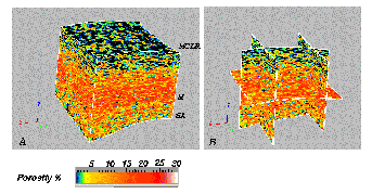
The markers used to construct the model, were MCLR (a marker within the lower portion of the Queen formation) that defines the top of the model, M (a marker defining the base of the main pay zone within the Grayburg) which occurs approximately 1/3 of the way up from the base of the cube, and SA (a marker at the Grayburg/San Andres formation boundary) which defines the base of the model which are shown on Figure 2. Figure 4 shows the total porosity data cube. The high porosity interval, with porosities as high as 28% in the middle of the model coincides with the main pay zone and corresponds with intervals having secondary vuggy porosity. Lower porosities occur above and below the pay interval.
Permeability Cube
A cloud transform method was used to generate the permeability data cube. The steps involved in this method are summarized below:
Secondary Porosity Cube
The secondary porosity trace is based on the assumption that sonic porosity is only representative of the matrix porosity, and that the difference between the transform total porosity and sonic porosity indicates secondary porosity.
The geostatistical distribution of secondary porosity was generated using the secondary porosity trace and the same variogram model used for the total porosity cube. Two different correlation lengths were used to generate two secondary porosity cubes. These cubes, with correlation lengths of 100 and 400ft, were named SP1 (Figure 6) and SP2 (Figure 7), respectively.
The secondary porosity models of Figures 6 and 7 were superimposed on the permeability cube and any cell in the model with Df of more than 8% was assigned an artificially high "vuggy" permeability. In this way, permeability streaks could be added to the permeability cube to reflect a contribution from the vuggy layers. Vug permeabilities of 3, 4, and 5.5 Darcys were assigned to build different models based on both Figures 6 and 7 for comparative purposes. These values were picked because: (1)the brine permeability measurements on whole core samples taken from the "vuggy" intervals showed Darcy range values, and (2)the highest values of permeabilities in the fk scatter diagram are greater than 2 Darcys. These six models, along with a detailed data cube of permeability without the superimposed vugs, were analyzed and compared by generating fluid flow simulations.
Simulation Models
Scale Up
The detailed geologic models were scaled up to 12000 cells to make them a practical size for simulation runs. Chevron's proprietary software for Scale-Up of 3-D Corner Point models (SCP) was used to scale-up the detailed models (106X100X100) to coarse models (20X20X30). This was accomplished by identifying the dominant flow paths in the detailed model through solution of a single phase flow problem. This information is then used to selectively scale up the reservoir properties, leaving details in regions where required and coarsening in other regions. 6 Permeability distributions in the scaled up models were examined to see how well they honor our overall understanding of the reservoir geology. The scaled-up models are called 3SP1, 4SP1, 5.5SP1 for the SP1 cubes and 3SP2, 4SP2, and 5.5SP2 for the SP2 cubes respectively. The scaled-up model without vuggy permeabilities is called Nvug.
The permeability distributions of the scaled-up model was examined to determine how well it honored the overall understanding of the reservoir geology. Figure 8 shows the distribution of different ranges of permeability after the scale up of 4SP2 model. This figure shows that the "vuggy" features (k > 2000 mD after scale-up) are distributed between a series of high permeability "non-vuggy" matrix (100 < k < 1000-2000 mD) as well as lower permeability matrix (30 < k < 100 mD). Figure 8 also shows that the producing interval is confined by very low permeability reservoir rock (0 < k < 5 mD). This generalized permeability distribution agrees well with the current geological model of the low-pressure area.
Input Properties
Chevron Extended Application Reservoir Simulator (CHEARS) was used for primary and waterflood simulation of the generated models.7 Oil properties for the simulation runs were measured for a sample of the reservoir oil with an API gravity of 32 and a bubble point of 805 psi at a reservoir temperature of 88 F.8 These properties are shown in Figure 9.
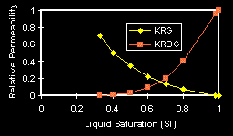
Two relative permeability regions were assigned to the reservoir: one to the matrix and the other to the "vuggy" zones. The water-oil and gas-oil relative permeabilities used for the matrix were measured using a steady-state method on a 20 mD core sample from one well. Figure 10 shows these measured relative permeabilities. Straight line relative permeabilities were assigned to the "vuggy" zones. A ratio of vuggy to non-vuggy rock greater than 50% was used to differentiate vuggy rock from non-vuggy rock in the coarse-grid simulation models. Except for the critical gas saturation, the end points were the same for both matrix and vug relative permeabilities. A "vuggy" zone critical gas saturation of 7% was used for the depletion part of the history. For the displacement processes critical gas saturation in the vuggy zones was set to zero. Three phase relative permeabilities were calculated by a linear interpolation technique.
The simulation models were initialized using a fSo-f transform developed from mercury injection measurements on 506 core samples taken throughout the field.
History Matching
Fifteen wells occur in the modeled area (Figure 11). Among these 9 are producers (P1 to P9) and 6 injectors (I1-I6). The cumulative oil production at each producer and cumulative water injection at each injector were controlled to be the same as the historical field production and injection data. The quality of history-match was determined by comparing the model and historical oil production rate and water-cut. The average reservoir pressure was also examined for consistency with field data, but was not a primary history match variable.
Results and Discussion
Waterflood History-Match
The permeability and the correlation length of the vuggy zones were examined in the history matching process. Comparisons of water-cut and oil rate with the historical field production data for the 4SP2 and NVug models are shown in Figures 12 and 13 respectively. As shown by these figures, models without "vuggy" intervals are not able to match the water-cut and oil rate (Figure 13). In contrast to NVug, the 4SP2 model does an excellent job in matching the oil rate as well as the water-cut (Figure 12). We feel these results are good evidence that vuggy zones are indeed playing a major role in the production from the area of McElroy Field that was modeled. Figure 14 shows the history-match for models 4SP1. Although better than NVug, the 4SP1 model is not able to match the history as well as 4SP2 (Figure 12). We conclude a correlation length of 400 feet (about the same distance as the well spacing) better characterizes the vuggy zone than a correlation length of 100 feet. The sensitivity of the history match to vug permeability was examine by assigning 3 and 5.5 Darcys to the vuggy intervals. Figure 15 shows that 3 Darcy permeability reduces the quality of history match. Increasing the vug permeability to 5.5 Darcy improved the match quality (Figure 16).
The quality of the history-match
for each of the nine producing wells in the study area was checked to confirm
the integrity of the spatial representation of the vuggy zones in the model.
Comparisons of water-cut and oil rate with history data for three of the
wells in the model area (P3, P7, and P8) are shown in Figures 17, 18, and
19 respectively. There is a very good match for these wells, which further
increases our confidence in the nature of the model. A good match was in
fact achieved for all of the wells in the model area, with the exception
of two wells that are located at the corners of the model. In these boundary
wells, the water flow from the outside injectors is not captured, however
the model has been able to match the water breakthrough times for both
wells. The good history matches obtained well by well indicate the model
captures the proper spatial representation of the vuggy intervals as they
affect individual well performance.
Producing Mechanisms
Figure 20 shows a comparison of all the regions of oil saturation greater than 50% in the model at initial time, after primary recovery, and after waterflood stage. This figure also shows the regions of gas saturation greater than 20% after primary recovery, and regions of water saturation greater than 65% after waterflood. This figure clearly shows the depletion of oil from both vuggy and non-vuggy portions of the reservoir during primary depletion, whereas oil is mostly swept from the vuggy portion of the reservoir during waterflood. The regions of water saturations greater than 65% shows that vuggy zones play a major role in connecting the injectors to the producers leaving most of the oil by-passed in the non-vuggy portion of the reservoir.
Conclusions
We are especially grateful to Leon Roe, Minhtrang Doan, and Bob Ehrlich for their help. We thank W. T. Dees who generated McElroy LPA transform phi logs. We wish to thank Alan Bernath for his assistance with the modeling and his extremely helpful suggestions. We would also like to thank R. F. Meyer and E. F. deZabala for the CT scan images. Finally we would like to thank Chevron Petroleum Technology Company and Chevron U.S.A. Production Company for permission to publish this work.
References