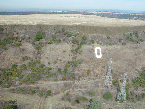
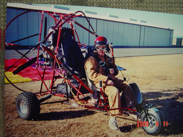
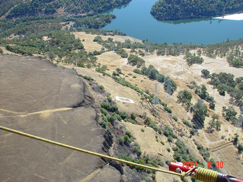
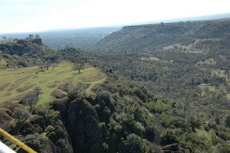
(Photo of South Table Mountain courtesy of Mike Moudy, who took it while flying his Powered Parachute in September 2007. For more aerial photos, see Section 3.)
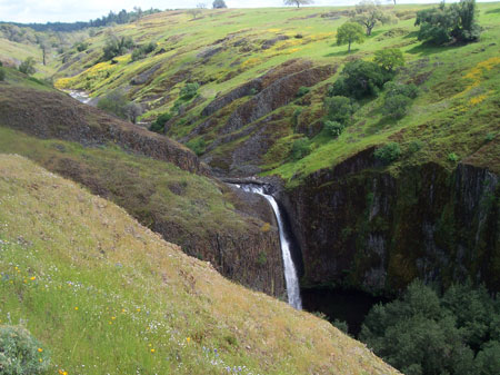
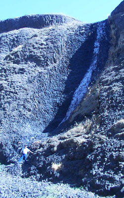
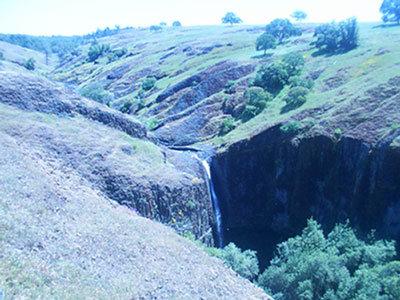
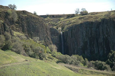
Beaston Falls on April 23, 2006.
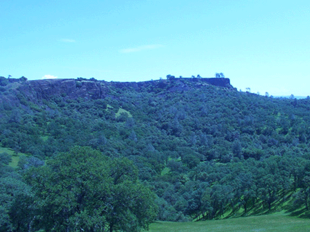
A view of the "High Rocks" on Table Mountain.
A BEAUTIFUL PLACE
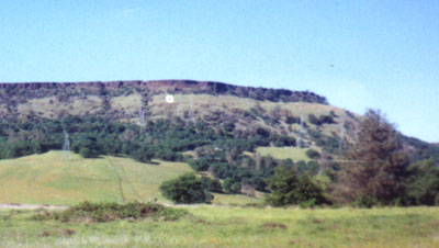
For the majority of the year it is green and full of wonderful wildflowers. However it only takes a few weeks of 90+ weather to reduce the color to yellow-brown. During the summer the heat exceeds the 100 degree mark and the mountain then looks barren.
I have hiked the mountain innumerable times since 1972. It is wonderful to explore the green, tree lined mesas that extend themselves north-eastward toward the Sierra Nevadas.
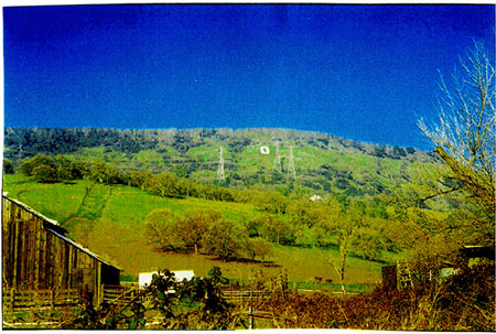
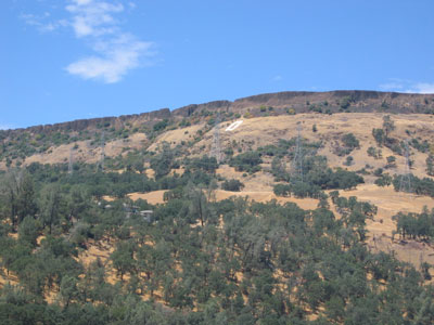
Even those who have lived here all of their lives don't realize that the mountain is in two distinct pieces. The southern table is the most obvious: the one with the concrete "O" on it that faces Oroville. If one hikes the first table he or she will see that on the northern end the mountain drops off into a valley. In the middle of that valley lies a small butte and the other, larger part of Table Mountain lies just beyond.
Those who drive up Cherokee road do not usually realize that this drop exists and think that both parts of the mountain are connected.
The northern table is the largest and when someone arrives at the top of the second table via Cherokee Road he or she will realize that this table extends from Cherokee Road to the south-east toward Oroville Dam for several miles. It also extends northward for miles until you come to the old diamond-mining ghost town of Cherokee and Highway 70. (You just continue up Cherokee Road to get there).
The mountain is dotted with unique lava formations. During the winter there are many beautiful waterfalls that decorate each of the mesas.
Check out the rest of this website as it has:

SECTION 1: INFORMATION AND HISTORY ON THE BUILDING OF THE "O" ON TABLE MOUNTAIN.
(CONSTRUCTION OF THE "O" WAS COMPLETED ON JUNE 8, 1929!)
SECTION 2: INFORMATION ON VARIOUS HIKES AND ACCESS TO THE MOUNTAIN. (With a lot of photos)
SECTION 3: AERIAL PHOTOS OF TABLE MOUNTAIN.
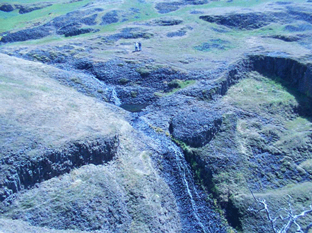
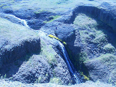
View of the Hollow waterfall on the North Table. 04-20-2002.
(Taken from the cliff above. Note the size of it in comparison to the two hikers above!)
I made my first hike into the "O" on July 1, 1972 with my friend Eddie Harrison. It was over 100 degrees and the pictures I have of it show we were burned and wiped out. (AND stupid for having gone up there in that horrible heat!)
For years I wondered how and when the "O" was constructed. During my high school years (1965-1969) I was told it was built by Oroville High School students but not much more was told about their effort. Then in 1989, a columnist for the local paper wrote a wonderful article on it. I am reprinting the majority of it here as it fully explains just how special the "O" on Table Mountain is.

The Oroville High School Class of '29 put the "O" on Table Mountain.
If you have been to the "O" you no doubt found yourself sitting down near it, catching your breath after the strenuous climb, and wondering about those that made this 60 year old symbol of our town. It's a wonder all right.
The view from there is impressive. The same can be said for the planning and effort that were required to plan the mammoth mountainside monogram.
Dedicated on June 8, 1929 by Morrow Steadman, the big "O" has a concrete thickness of four inches, and was measured by it's builders to be 87 feet by 33 feet. It was intended to last through the generations and convey a spirit of good sportsmanship in local high school athletic events.
It was to have another meaning too. Steadman wrote in the '29 OHS Yearbook, the "Alpha" and said he hoped the "O" would remind students of "cooperation and teamwork, both on the athletic fields and in our school activities".
Steadman, a lawyer in Oroville until his untimely death in 1959, is said to have been inspired by the huge block "C" that once rested upon a hillside overlooking Strawberry Canyon on the campus of the University of California at Berkeley. According to classmates, Steadman and his brother Ernie Steadman were most responsible for planning the Oroville construction and seeing it through to it's completion.
Building the "O" was yet just an idea as late as midterm graduation time in February of 1929.
Imagine what it would be to tote a sack of concrete up the rocky incline. The job required immense amounts of physical labor. This was not a stroll in the park. This was no group of aerosol can paint vandals. They were not slingshot-wielding window breakers.
These were enterprising, pre-Depression era, hard-working kids.
It took a special talent to motivate others in that ambitious Table Mountain project. It was an attitude and is perhaps best represented by a remark made by student body President "Rusty" Jacobs - "There is going to be a Block "O" on Table Mountain if he and Morrow have to build it".
It looked as if they might have to for awhile. According to Chambers, the number of volunteers was quite small, and reached a low point about half way through the work. "Just a few were really dedicated to working up there". Then Ernie said, "Let the girls come up with some food". "We really got some work done after that".
Douglas Chambers was the Steadman Brothers' choice for surveyer for the layout. He said he took a transit shot from the 50 yard line of the OHS football field (now covered by classrooms) to Table Mountain. Then a followup sighting from the mountain to the school was performed. Next a huge paper "O" was laid upon the slope and critiqued from far below.
After these preliminaries, the boys built a sled to help them pull drums of water and other heavy things up a particularly steep pass. They even managed to hoist Chambers' Model-T Ford up near the site. It stayed on the hill during the project.
Three other trucks employed below moved things closer to the mountain. Chambers said the Steadman loaner was turned on its side at one point. It was a non-injury accident, but added to the work load.
The students were allowed to cross through land owned by the Retson brothers, a family that also assisted by loaning tools and caring for horses used by the builders.
Student Ray Johnson's father (Ray Johnson became a Senator) owned an automobile shop from which a supply of axles was furnished. The metal was then driven into cracks in the lava rock before cement was poured.
Chambers mentioned that the crew had a gasoline mixer up there, and numbers that were kept showed that a total of 108 sacks of concrete were dumped into the forms.
The Class of '29 finished the job in a little over two months. It was a feat which many elders in Oroville did not support.
Chambers said, "They thought we were nuts. We decided to show them what we could do."
Today the "O" is still maintained by OHS students, but perhaps not with the same regularity known in previous years. Maybe it is time to realize that the "O" has grown to represent more than one high school. The symbol is also seen as a landmark for the entire community, and that includes both Las Plumas and Oroville High Schools.
Left by the graduating class of '29, the "O" is lasting proof of their devotion. For 60 years, their creation on the mountainside has endured while one high school of "about 195" expanded into two. It has looked down as the population and town boundaries changed too.
The "O" represents us all, and if it could talk, it might say, "I have seen you grow from a small town into a larger one, and I'm happy to be up here to be a symbol of it".
That's the Spirit of '29.
POSTSCRIPT:
My thanks to Dan Wilson's efforts from 1989! A great article that answered a lot of people's questions.
HAPPY 94TH BIRTHDAY TO THE "O"!!
The "O" on Table Mountain. Looking over the valley for more than 9 decades.
The "O" turned 94 years old on June 8, 2023. I doubt that the residents of Oroville do much but take the "O" for granted, but just imagine the "O" watching over the town of Oroville since June 8, 1929: Through the Great Depression, December 7, 1941, World War II, Nuclear Power, Korean War, Vietnam War, Television, Landing on the Moon, computers and September 11, 2001. (not to mention Microwaves and the Edsel!)
It's very nice to know that as of September 2010, both Morrow and Ernest Steadman will have been entered into the Oroville Union High School District Hall Of Fame. Their work on building the "O" has had an effect on more people in the Northern California area than we will ever know! The "O" is still a great inspiration.
THANKS FOR THE E-MAIL!: I received an e-mail from Morrow Steadman's daughter, Ann, on September 23, 2001. Thanks, Ann for your kind thoughts. Any time you want to hike to the "O", just let me know! I am more than ready!
THANKS FOR THE E-MAIL!: I received an e-mail from Dan Wilson, author of the article on The "O", on February 4th 2005. What a great e-mail!
Here is some of what Dan had to say:
"I am writing you, first, to say thanks for the kind words about the article you displayed on the website. Second, this update will inform you that I painted the "O" January 29 + 30, 2005.
So what I am doing now, Larry, is continuing with a plan to draw more attention for the maintenance of the symbol on the Table. I still live here in Oroville, class of '63, and find the clean up work to be a labor of love. However, there is my age factor to consider, no spring chicken anymore. Added to that, is my concern that the Oroville High School is faced with a growing concern about protecting the students who occasionally maintain the structure. As you know, it is dangerous up there. I am worried of the aftermath should some sort of accident happen if kids were asked to fix the "O".
My trip last week was a similar one: repairing the letter to its original form. It's always touchy, because usually the "O" is altered because some young person in the area has died. So I waited three weeks to transform a "J" back to the "O". There were kids up there on Sunday to see who was destroying their handiwork. No problem, and they seemed to gain a lot from the on site history lesson I recited to them while I painted.
In short, I plan to offer a presentation to the City Council. I hope to see if the High School can be taken off the hook, as far as being commonly assumed to bear the cleaning responsibility. I would gladly do it, but I need some funding.
Also, I will move on having the "O" declared a State Historical Monument. That recognition may help with the preservation.
The old slab is in need of a true overhaul, sandblasting, etc. The paint is loose in many spots, and breaks off in large sheets. That is a risky place to send inexperienced young ones. Hiking there is one thing, carrying heavy paint buckets and such up there is quite another.
Thanks again, and I will see what I can do."
Dan

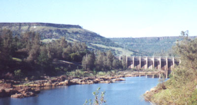
Long distance view of the "O" with the Thermalito Diversion Dam in the Foreground - March 31, 2001.
AN ANCIENT HIGH SCHOOL MEMORY:
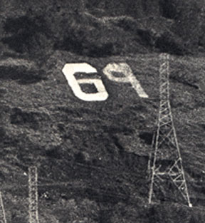
Some of my OHS Class of '69 classmates, namely Barry Duensing, Michael Scroggins and Brian Thompson (and I am sure there were others) in June of 1969, just before our high school graduation, changed the "O" to a "69". I still remember them stumbling into first period English (or was it second period?!)(anyway it was Mr. Loch's class) the last morning of school, dirty and wiped out, after having spent the night transforming the "O".(they may have had a little help from Johnny Walker or Bud Weiser). That memory is one of the highlights of my high school career. (AND one of the funniest!) Sadly, Barry reports that he doesn't remember this. I WONDER WHY!!!!
The picture of the "69" on Table Mountain was taken by an unknown Oroville Mercury Register photographer. It appeared in the Mercury, our Oroville High School "Tiger Tales" newspaper and our OHS yearbook, The Nugget.
SECTION 2: INFORMATION ON VARIOUS HIKES AND ACCESS TO TABLE MOUNTAIN:
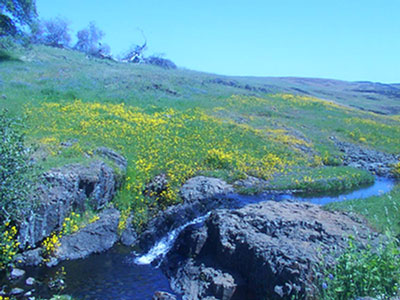
Water flowing toward the Waterfall on the North Table. 04-20-2002.
Sadly, seeing the sights of the North and South Table Mountain areas has become more difficult in the past 5 years. South Table Mountain has remained as accessible as always: In other words you can hike to the "O" but don't leave a mess and the private land owners will not hassle you.
North Table Mountain used to be fairly free access. However, due to a few disrespectful persons who left trash and who did damage to cattle, many land owners do not allow you on their property anymore. I had taken many hikes from the top of North Table Mountain all the way south-eastward toward Oroville Dam to the Microflect tower. But now that area is closed. That is also the area where people used to fly kites during the Spring. Further up Cherokee Road from there are few areas where you can have access. It is a sad commentary that a few people have ruined access to Table Mountain for many others.
I greatly appreciate the few private landowners who still allow access to this beautiful area. I was pleasantly surprised on September 22, 2001 that there is actually a good gate to the wildlife area and you can have easy access to the area of the waterfalls on the North Table.
I have had quite a few people ask me for directions on how to find the Hollow waterfall that is described and pictured below in the various "Waterfall Hikes". Be aware that this area is now under State of California control and there is a fee for entry. I am not happy about this. Also, due to a lot of promotion, many people visit this area in the spring of each year to see the wonderful wildflowers. Here are the directions: You access Cherokee Road from Table Mountain Blvd in Oroville. You follow Cherokee Road to the top of the mesa. A few miles farther you will see a very large Oak Tree on the left side of the road. I estimate the tree to be about 5 miles from the beginning of Cherokee Road. Near the tree you will find a parking lot. Just follow the creek West and it will take you to the Hollow waterfall. You can access the bottom of the falls by the trail on the left, or South side of the falls. The trail is a bit tricky so watch your step. Once at the bottom you can follow the creek for several miles and it takes you to the Beaston Falls area. Mark your trail well as you do not want to get lost. It's a beautiful area so pack out what you pack in. Also, BEWARE, on April 3, 2021, a hiker died in the area of Hollow falls. Be careful out there!
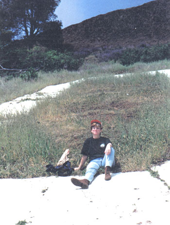
HERE IS MY WIFE SHARON AFTER CONQUERING THE "O" FOR HER FIRST TIME ON THAT SAME DAY. SHE IS NOT TIRED AT ALL! (The tree in the background has since fallen off the hill! I found it down in May 1999.)
VIEW LOOKING TOWARD OROVILLE AND CHICO FROM THE "O". SCOTT IS STILL CLIMBING UP THE HILL. MAY 6, 2000.
SCOTT CLIMBING ABOVE THE "O" TOWARD THE TOP OF THE MESA. MAY 6, 2000. (The "O" and the fallen tree are below him.)
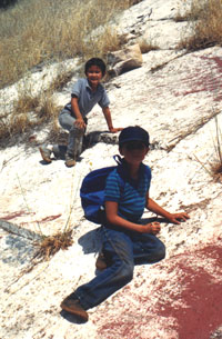
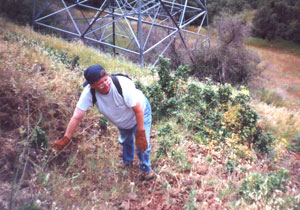
PHOTO OF KENNY ZANON AND ALAN MATTHEWS SHOWS JUST HOW STEEP THE "O" IS. SEPTEMBER 23, 1987.
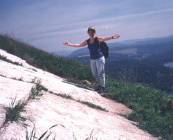
SHARON MATTHEWS SHOWING THE "JOY OF MAKING IT TO THE TOP!" MARCH 30, 1996.
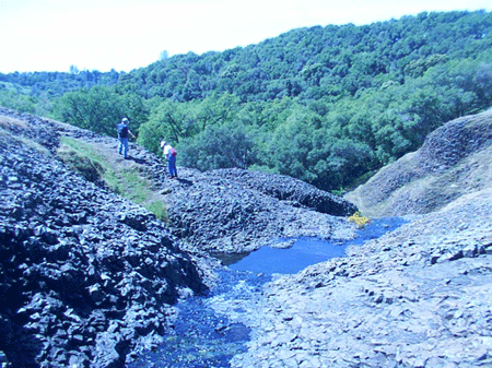
THE DRY WATERFALL HIKE - SEPTEMBER 22, 2001!
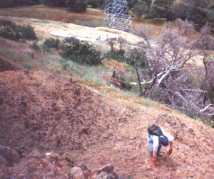
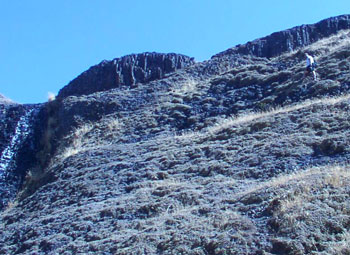
This hike to the Hollow waterfall on the North Table graphically illustrates how dry the mountain is after the Summer months of 100+ heat. The following photos show me in front of the waterless fall and Scott Roberts climbing out of the box canyon that makes a climb into the falls a bit of a challenge.
During the Winter and Spring the water basin below the falls is several feet deep and the falls roars for most of the year. The first time I visited this 100 foot waterfall was in April of 1969.
All in all, a dry, but beautifully rugged day. No - that's not water - only a water stain on the rocks.
THE WATERFALL HIKE - APRIL 20, 2002!
In April, Scott and I decided to revisit the Hollow waterfall area, mainly to check it out when it was green and when there was ample water in the stream. We also wanted to acquaint Scott's girlfriend, Judy Brown with the area. To say the least we were not disappointed and had a wonderful day. You can enjoy the day with us by viewing the various photos of our trip on this website dated 4-20-02.
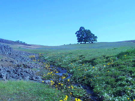
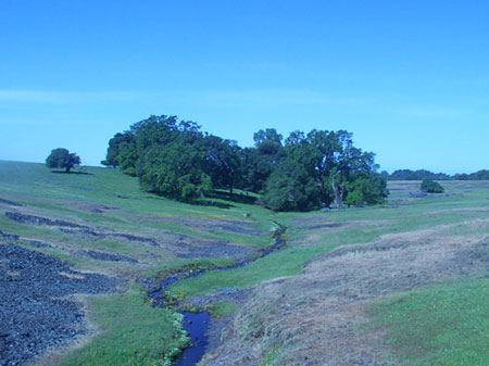
Spring Wildflowers along the Creek. North Table Mountain. 04-20-2002.
(Yes, those are cows under the tree.)
THE HOLLOW WATERFALL AREA HIKE - MAY 17, 2003!
My wife Sharon and I, decided to take another hike up to the waterfall area on May 17, 2003. She had not been up to that area for several years. We hiked several miles and ate our lunch under a tree. We then ran into a couple of other hikers who told us about another waterfall farther West of the waterfall that we normally go to. So we went out to an area that we had never been to. It was well worth it! Below you can see several pictures of our day on the mountain. They include a picture of the newly found waterfall, that is located almost on the edge of the west side of Table Mountain. I later found out that this waterfall is known as Beaston Falls. It amazes me that even after years of hiking on the mountain, I am still finding new, beautiful discoveries.
A small, yet very scenic, waterfall on the way to the Hollow waterfall.
Another shot of the Hollow waterfall from the cliff. This time my wife is the lone hiker below.
The "newly discovered" waterfall on the West end of Table Mountain - Beaston Falls. Thanks to Kirk Roby for correctly identifying the name of this falls.
MY LAST HIKE TO THE "O" - NOVEMBER 11, 2005
It was Veterans Day and I suddenly realized that it had been over 5 years since I had last climbed to the "O". As everybody else was either working or was unavailable I decided to do something that I had never done - and I don't recommend. I hiked to the "O" solo. Even though I had a cell phone to call for help, I had nobody to help carry my body back down if I had broken a leg.
Here are a few photos I took that illustrate how it went.
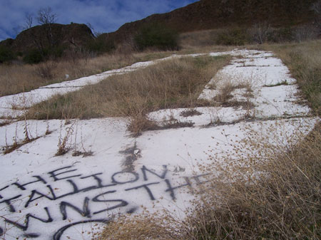
Here is the "O" showing graffiti spray painted by Brittney Spears Fans. They need to come back up and lick it off!
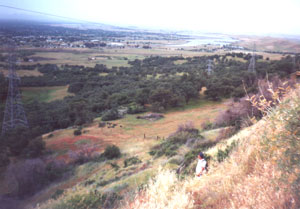
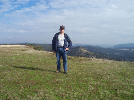
Here I am on top of the mesa. The camera's looking toward the East. Yes, I am alone. Photo was taken by my trusty time-delay digital camera atop a tripod. You can see Monte De Oro and the Oroville Dam spillway in the background.
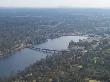
Here is the scene looking South toward Oroville with the train bridge and Thermalito Diversion Dam.
All in all a very nice day atop Table Mountain. I had forgotten just how tired you get climbing up that hill! Had to stop quite a few times to catch my breath on the way up. But as usual it is a wonderful trip and a million dollar view once you get on top. I also walked northward to the end of the mesa and back and then came back down the way I had come up. I spent about 3 hours on the mountain that day. Five days later my leg muscles still hurt!
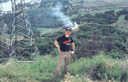
SECTION 3: AERIAL PHOTOS OF TABLE MOUNTAIN.
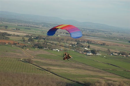
Mike Moudy and his Powered Parachute
My thanks to Mike Moudy and Valerie Phelps for their permission to use their great aerial photos.
Over The "O" - taken by Mike Moudy
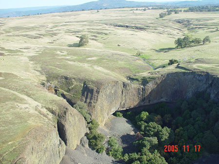
Crescent shaped cliff with Phantom Falls at end of Coal Canyon - taken by Valerie Phelps
Beaston Falls - taken by Valerie Phelps
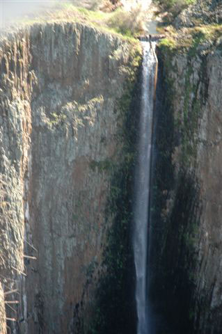
Closeup of Phantom Falls - taken by Valerie Phelps
The "High Rocks" with Morris Ravine and the South Table in the distance - taken by Valerie Phelps
Mike Moudy in flight - taken by Valerie Phelps
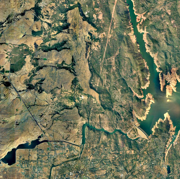
Satellite view of the Table Mountain area. From the "bend" in the river you can see Oroville Dam to the right. Going NorthWest from the "bend" you can see the South Table, the small knoll and then the two part North Table.
Please check out all of my High Quality web sites at:
THIS IS A "LARRY" WEB SITE.
This website was last updated on June 8, 2023.