|
 |
|
|

Situated in N.W. Canada, the Northwest Territories is 1,304,896 square miles. It stretches from East of the Yukon to West of Hudson Bay, all being North of Latitude 60° N. It also includes the islands in Hudson and James Bays and in the Hudson Strait. The area is divided into three administrative districts: Keewatin, West of Hudson Bay; Mackenzie, East of the Yukon; and Franklin, in the north, including the Archipelago. Geographically the area is divided by the tree line that runs northwest to southeast from the Mackenzie River delta to the Churchill area on Hudson Bay. Tundra inhabited by Eskimos and Native Americans, extends over much of the north and east. Much development has taken place in the Mackenzie district, which is heavily forested and rich in minerals. The district contains the large Great Bear and Great Slave lakes. Mining is he major industry, and deposits of lead, zinc, oil, gold, and copper have been exploited. Trapping, the region's oldest industry, ranks second in economic importance. Great Slave Lake has a thriving fishing industry. Highways and railways are limited, and air transportation remains important. The City of Yellowknife is territorial capitol.
The Arctic Circle is an imaginary line which runs parralled to the equator at 66 degrees 30 minutes north. It is not the boundary for the Arctic, but it is significant to note that, north of the Arctic Circle, at the summer solstice (June 21) you will find the sun above the horizon through the 24 hours of the day. This phenomenon is reversed at the winter solstice (December 21) when the sun is below the horizon for the 24 hours of the day. This is where we get the sayings,Land of the Midnight Sun and Land of the Long Night.
 |
Chosen as symbolic of the bold new spirit of Canada's Arctic Northwest Territories, the Polar Bear, as he is artistically depicted in the Arctic Blue Circle, is truly representative of the adventurous, hardy people who come to live and play in this vast frontier of unlimited opportunity and vigorous development.
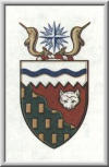 |
The Shieldis divided into three sections representing the three physical divisions of the Northwest Territories -- the Arctic or ice area; the tundra or barren land; and the wooded region to the south and west below the tree line. The section referring to the Arctic carries a wavy blue stripe symbolizing the Northwest Passage. The saw-tooth edge of this white section is suggestive of the edge of the polar sea ice.
The red section represents the barren lands ad the green section, the wooded area of the Territories. The wavy diagonal line symbolizes the tree line which separates these two regions.
The head of the white fox is intended to represent the fur industry, the gold billets refer to the mineral resources.
The Crestdisplays a compass-rose intended to symbolize the Magnetic Pole which is located in the Northwest Territories. It is being guarded by two olden narwhals, an animal characteristic of the Canadian Arctic.
|
| | Home | Introduction Page | Yellowknife | Northwest Territories | |
| | Great Bear Lake | Branson's Lodge | Thumbnail Pictures | My Trophies | |
Copyright © 2003, Northwest Territories, All Rights Reserved.