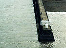
Photo with kind permission of Trinity House. Please note that any items in RED means there is a fuller version relating to this particular name or subject, which can be found in the Main Search index. POSITION: 54� 43'.10 N 03� 30'.50 W Location: South Pier - Maryport Harbour - Solway Firth No. on Admiralty list of lights: 4676 Officially established: September 1796 Designers/Builders: Maryport Harbour Trustees Original structure: Wooden pole with enclosed gas lamp Height of structure: 14 ft (4.26m) Height above mean high water: 32 ft (9.75m) At the mouth of the Solway Firth in Cumbria, is the harbour town of Maryport. It was previously known as the harbour of Ellen Foot, being the mouth of the River Ellen. Its name changed following an Act of Parliament in 1756 when the owner of the land, Humphrey Senhouse II obtained official approval for township status. It was named after his wife Mary. With a natural harbour this owner realised the potential business opportunities and had orginally applied for a developement grant in 1749. The Senhouse family had numerous connections with the sea. The eldest sister of Humphrey Senhouse, Bridgett, was the grandmother of Fletcher Christian, better known for his exploits with the Mutiny on the Bounty and Captain Blythe. However the arrival of Sir James Lowther, who took over as owner of Maryport and much of the surrounding land, saw a dramatic increase in sea trade. Yet prior to 1796 there was no official navigational light. The only aid was provided by a concerned shop owner called William Curry, whose property was situated at the bottom of Shipping Brow. He would light his coal gas lamp inside of his shop window each night. However this situation changed when he asked the newly formed Harbour Trustees for financial assistance towards the upkeep of his light. This committee refused his request after which time William Curry did not light his gas lamp. In turn the Harbour Trustees erected an enclosed gas lamp on a pole outside of the shop which was officially recognised in September 1796. By 1799 the North and South piers had been established, each with their own lights close to the harbour entrance. In 1834 the Harbour Trustees established a new unmanned gas light on top of the inner stone pier. It was constructed from cast iron piles and stone and stood about 35ft (10.67m) high. Its enclosed light was recorded as being visible for 12 nautical miles on a clear night. On the 20th October 1857 three years work taken in building the Elizabeth floating dock was completed. A new catadioptric 3rd order revolving light was also lit for the first time, with its illumination changed from white to red. To mark this event the first ship to enter the new dock was the steamer Cumbria. Although Trinity House was empowered to take over the Maryport lights in 1836, the Corporation declined to do so, leaving the management up to the Harbour Trustees. Between 1860 and 1961 two of the Maryport lights were phased out, leaving just the green light on the south side jetty, the red light on the north side Tongue Pier and the main South pier lighthouse. However in 1884 a major structural weakness for found with this cast iron tower, resulting in a new one being built. In 1946 the fuel source for the South Pier light changed from coal gas to acetylene. On the 6th March 1961 the South Pier light was donated to Trinity House. However the lighthouse looks more like a lifeguards watchtower, with its steel access ladder enclosed by a tubular safety cage. Its light source is a 20 litre open flame burner enclosed by a plate glass lantern. Its operation is fully automatic, with its acetylene light providing and intensity of about 120 candelas, through its 300 mm diameter dioptric lens assembly. Its visible range is 6 nautical miles. |
Maryport |
