|
Volume 14 Number 3 September 2006 |
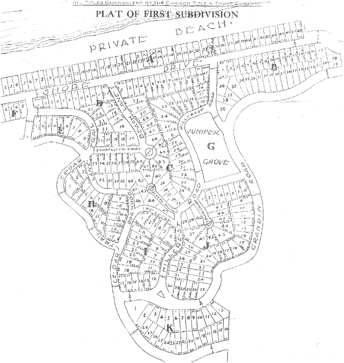
The 1976 A History of Ogden Dunes book mentions that, in 1938 or '9, the nascent Women's Club figured some street names "would have to be" changed so that street signs could be erected. Sometime before that was done in a couple years, the Town Board presumably officially changed them. That was not gone into much further but what was being referred to was the fact that some of the stretches of platted roads were not built (some of those remaining as town parkland today,) the names of driveable streets being discontinuous. The names of several main roads of town radically changing directions seems also to have bugged some people.
It sure would be nice to have the individual stories behind the five dozen past and present Ogden Dunes street names and their alterations but, if that information exists, this society doesn't have it. Some generalizations can be made however. Unlike the roads in the subdivisions of nearby Dune Park, Edgewater, and "the Boatdocks" off SR 249 (most of which have been abandoned or were never built in the first place,) where the idea was to parrot Chicago street names, most Ogden Dunes street names concern nature.
I don't know that we can assume those names were specifically relevant to those locations. Cottonwood Lane would have been a safe choice anywhere in town but were there a particular abundance of lindens along Linden Lane? Tamarack makes sense for a lane between two wetlands. I suppose there were black locusts around those two streets, as they're all over. How did those end up here anyway? They're not native to the area. Supposedly nobody but several squatters lived north of US 12 before Ogden Dunes was developed.
If aspens were most noteable along that road, it would have been along the west end, as that was platted before the north end. And the inspiring bittersweets would have been along the Lane rather than the Court, as Bittersweet Court was originally Aster Lane. Which brings up the question of why it was figured that that name change should be made. I sure don't know.
I suppose there were a bunch of little turret dunes along Turret Road but they are long gone now, replaced by houses. Indian Camp Trail's name refers to kids finding an Indian skeleton along the (old) shore of Long Lake. That name was different than earlier ones here. Of the six "trails" in town, that is the only use of the term for a platted dead-end. (Pine Trail wasn't completely built but it was platted as a through street.)
Ogden Dunes has included some more prosaic names. Line Road, named for its running along a government section line, was renamed Summit Road for its climbing Mount Everest, though that dune's former summit is now sitting under the water company plant in Long Lake. I assume East Hill Road was simply the easiest way of referring to the dune straddling the town line there rather than meant as an actual name for the hill. That does raise the question though of whether other dunes here have had names besides Mount Everest and Ski Hill. Or other natural features. Well, I guess the gully north of The Ledge is Sleepy Hollow, as that's what the unbuilt street down it was named. And the town and Home Association parklands east of Aspen Road and south of Skyline Drive are Horsethieves (or Horsethief's?) Hollow.
But back to streets: Ogden Road (which was applied earlier to a couple other proposed but unbuilt streets) is simply named after our town. How boring. At least they tried to spice up the stretch east of East Hill Road by platting it as Ogden Road East but the full name isn't used anymore. Perhaps it was considered too scary to have a direction at the end of a name like that. Likewise for Turret Road East.
The actual stagecoach road through the southern part of town was platted as Old South Road but the only portion of that followed by a paved road today is the stretch north of Tom Tittle's business. The other (now vacated) street names over there were prettier: Edgewood Court, The Terrace, Highland Road.
And Hillcrest Road, which used to extend south of US 12. It amuses me that the crest of the hill referred to by the name presumably is no longer on that street. Would you imagine that's at the curve just north of The Ledge? That stretch of today's Hillcrest Road was platted as Dogwood Lane. Today's Cedar Trail was platted as (the northern portion of) Hillcrest Road. The actual hill crest presumably referred to by the name is along Cedar Trail just south of The Ledge. I often sit in my backyard for hours laughing at the cars going by, their drivers oblivious to their cresting the hill of Hillcrest while thinking they're simply driving along a cedar-lined street.
And what of that? Well, there are white cedars along Cedar Trail but the name originally applied to the northwest end of Hillcrest Road, the southeast stretch of Sunset Trail, and an unbuilt strip of roadway (now town parkland) in between. Yes, the Women's Club plan did simplify things. Cedar Court was platted as the short dead-end Dunes (sometimes shown as Dune) Court. When northern Hillcrest Road was renamed Cedar Trail, Dunes Court was extended up the hill and renamed Cedar Court.
I guess the same idea was behind that as in the renaming of Aster Lane to Bittersweet Court. And likewise for Beach Lane. That name originally applied just to the portion south off Shore Drive. Today's one-way east off today's Hillcrest Road was platted as Sandcliffe Court. What a cool name. The town's residents had different ideas about street names than Mackenzie and Reck however. I suppose it is easier to find one's way along streets which don't change name at each curve. Now if only those computer mapping programs, which visitors to our town use, were based on accurate data.
As with Cedar Court, an easement was replaced by a paved road, which became Beach Lane Court. That raises the question, why not simply Beach Court? Why the double name? I sure don't know. Where did Grandin Road, the original name of the bulk of Ogden Road, come from? Good question. There was also a Grandin Court. It was left unbuilt, a resident allowed to use it for a driveway but not to pave it.
The ski jump here in town led to some other "unnatural" names, too. The north end of Ski-Hill Road started out as Viking Plaza, a dead-end extending as Skade Lane. Another (vacated) dead-end branched off that as Viking Lane. All that was off Norge Road, the original name for Woodland Trail. How much of that land was owned by the ski club, I haven't pursued. After the ski slide was torn down, the lots along the slide were reconfigured, the dead-end Skade Lane was extended, and it was all renamed Ski-Hill Road. More recently the hyphen has been dropped, due to discrimination against hyphens.
Boat Club Road was named less decisively. Maps originally showed it as simply a street "to boat club," as that road used to lead to the old Gary Boat Club, down at the mouth of the North Arm of Burns Ditch. Somewhere along the line, that started being called Boat Club Road. Perhaps a need was seen for most streets in town to be named. But then a streetsign seeming to indicate that three houses along Hillcrest Road are on Boat Club Road doesn't seem to bother people.
The stretch of roadway, between Hillcrest Road and Ogden Road northeast of Juniper Grove (the old tennis courts,) seems never to have been named. Maps simply labeled it "to Grandin" (the old name for Ogden.) Perhaps the developers had already decided it was unnecessary to build it.
Another oddity there is the street south of Juniper Grove. It was named Ogden Court after Grandin Road was renamed Ogden Road but it was earlier mapped as "Road." Had they simply not chosen a name for it yet? Was it considered short enough that it didn't require a name? Was it the eastern end of a discontinuous Sleepy Hollow Road, the confusion caused by the way the name was shown split on maps? That does not appear to be the case, as plats of those individual blocks also show those simply as "Sleepy Hollow" and "Road." Was the juniper of Juniper Grove meant to also apply to that road, it being Juniper Road? That also seems unlikely. Why bother worrying about aliens in Roswell? Who will run down the truth about Ogden Court?
My sister thought about our town's street names before I did. She pointed out to me, as a kid, that Diana Road was unlike other local street names, in having a person's first name on it. I assume most of you know that was named for early resident Alice Gray. Its old end extends west off today's Diana Road, that portion unbuilt except as a driveway. The northwest end of Sunset Trail was renamed Diana Road when Diana was extended south. Diana Place (a.k.a. Court,) the other street named after her, is nowhere near where "Diana" once lived.
Do the street terms of Ogden Dunes follow patterns in general? There aren't that many different ones used anymore. The only avenue here was never built so it doesn't serve much purpose to note that Forrest or Forest Avenue runs east-west along a town border. That is not specifically what avenues are known for in other places.
Ogden Dunes has had and still has a couple different kinds of courts. Some of them are dead-ends, while others are simply short connector streets. Likewise for streets named "The __." Our "places," on the other hand, are all dead-ends, while our only plaza (Viking) was a short connector street, renamed part of Ski-Hill Road long ago.
What do Shore Drive and Skyline Drive have in common? Well, they're both fun to drive along to look out at the Lake from but then that can be said about other streets, too. At least those were attempts to come up with things clever.
Most of the roads in town were just that, __ Road. The original idea for an Ogden Road was as a 100-foot-wide main thoroughfare stretching west from Hillcrest Road, along the north edge of the Indiana Harbor Belt Railroad. When that reached the Indian Boundary Line, it would have continued straight west to County Line under different names. The next Ogden Road was one of the options for the street parallel to US 12 and south of the highway. A South Ogden Road was considered cutting across the Fifth Subdivision quite differently than anything which was later platted. Instead we ended up with the Ogden Road we have today.
Can we draw any generalities about the other __ Roads in Ogden Dunes? Aspen Road narrowed and doubled back on itself as it was lengthened. Did Norge Road's nature change when its name was replaced by Woodland Trail? The term trail here resembles court in being applied to either dead-ends or to connecting roads not longer than several blocks.
When the historic Old South Road was replaced by today's Stagecoach Road, different properties were given main street access. When East Hill Road was extended through the Fourth Subdivision, it did not connect up with the original East Hill Road. What conclusions can be drawn from those facts? 'Good question.
Did the different __ Trails start out as the same sorts of streets? If only the developers left the answers to all of that sort of question or if there was a historical society here 3/4 of a century ago instead of just a decade ago.
But then maybe I am the only one to take an interest in these things, considering how long it took others to notice Shore Drive extended farther than they'd thought. I'd assumed everybody else had already realized that.
Historical Society of Ogden Dunes, Inc.
115 Hillcrest Road - 101
Ogden Dunes, IN 46368-1001
|
|
|||||||||||||||||||||||||||||||||||||
| Basic $15 | Supporter $35 | Historian $50 | Leader $100 | Lifetime Member $500 |
![[WEBMASTER E-MAIL]](../../letter.gif) |
 |
Hour Glass |
![[Historical Soc. of Ogden Dunes]](../../home.gif) H.S.O.D. |
|---|