
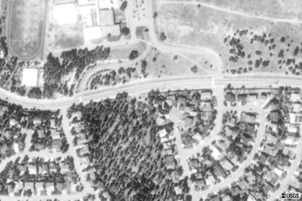
Our house 1604 Camino Uva, Los Alamos, NM 87544-2727; on Parcel: 1034113214258 Subd: Cumbres del Sol Block: B Lot: 118 S: 10 T: 19N R: 6E at plus code 857MVPV4+23, 35° 53' 33.18'' N 106° 17' 41.28'' W (35° 53' 33.0864'' N 106° 17' 41.4348'' is UTM zone 13S Northing 3972802.1445482 Easting 383137.59897252. According to Garmin the garage is at: 35° 53' 33.0936'' N, 106° 17' 41.3772'' W at 2242.14 m = 7356.10' above Mean Sea Level; EGM96 Mean Sea Level is about 19.560m=64.17' below the WGS84 Ellipsoid here; The EGS2008 model may have 17.24m=56.56' instead) in the North Mesa region of Los Alamos (Carrier Route C017, Delivery Point 04, Check digit 04, eLOT 0056 A; FIPS code 35 028 000100 2 001) can be seen below (middle house in cul-de-sac):
 |
 |
 |

|


The ground floor area is 1315 ft², and the second floor is 860 ft². The 2-car garage is 486 ft² and porches and portals total 141 ft². It was advertized as about 2225 ft² (about 207 m²) and is a four bedroom 2¼ bathroom south facing multi level house on about 8581 ft² lot—a bit more than 797 m², slightly less than 12 West Bengal kAThA (and more than ½ West Bengal bighA); about 0.1928 acre—facing a cul-de-sac and backing on to the main road. Official records list it as 2326 ft², 4 beds, 2¼ bathroom property on a 8400 ft² lot, most realtors list it as 2225 ft² on 9148 ft² lot. It is a forced-air heated stucco house with shingle roods and an open floor plan with 7 rooms on 1.5 floors.
The Spanish influence is very strong in New Mexico. In Spanish, mesa means a table, and here it is used for a plateau. Camino means a lane and uva means grape. Cumbres means a hilltop and sol is the sun.


Sitting on top of the Santa Fe Group of sedimentary rocks, this entire region was formed out of a volcanic explosion at the Rio Grande rift: volcanism began about 13 million years ago, and continued in these mountains till 0.13 million years back! Los Alamos itself is the result of 2–3 million year old volcanism. Faults still crisscross this region: The townsite is separated from the Pajarito mountainst on the west by the Pajarito fault, the Rendija Canyon fault passes west of our house, and the Guaje Mountain fault ends just north east of it.
Humans came much later: All of Americas were probably peopled by migrants out of Africa who may be related distantly to Siberian Turkic people. They came to the Americas probably around 15 thousand years back and their traces are found in New Mexico from at least 10 thousand years ago. Culturally, this region is currently diverse featuring many distinct linguistic and cultural groups. The first settlers in the Pajarito region were probably the Keresan speaking people who came from Arizona around 950 AD and farmed the mesatops here between 1175 and 1250 AD without artificial irrigation, and the people of the nearby Cochiti pueblo are probably their descendants. They were followed in about 1300 by the Tewa speaking people who probably came from the Mesa Verde and Chaco Canyon regions, possibly in response to the great drought from 1276 to 1299, and their settlements were probably defensive against the Navajos and the Utes, who may have been late comers to the American landscape. They drifted away after a generation or two, probably in response to growing drought; and may have populated the neighbouring pueblos like San Ildefenso and Santa Clara.

By 1550, the mesatops were unfit for cultivation and abandoned, though the Pajarito plateau was still used by the people of San Ildefenso as a grazing common. The Spanish under Oñate arrived in this region in 1598 after the Spanish King Philip II issued a cédula authorizing the conquest of New Mexico in 1583. The names of most major geographic features in this region dates back to the Spanish era. In 1742, the Spanish crown awarded Pedro Sánchez of Santa Cruz, whose mother had been killed by the people of San Ildefenso, a land grant for his service to the colony of New Mexico, and this extended up to the current Pajarito road and abutted or encroached the traditional grazing lands of San Ildefenso. They are known to have been grazing cattle in this region by 1749, and a Sanchez lived in Pueblo canyon in 1763. Even though in 1765, Governor Capuchin declared that the Sánchez grant was abandoned to the Pueblo of San Ildefenso, it was revived in 1851 when the grant, to eight interests in the region from the Abrevadaro del Rio de Los Guajes to the hill of the Rito de los Frijoles, excepting the interests of three heirs, was sold by Antonio, a claimed descendant of Pedro's son Francisco, to Jose Ramón Vigil of Española. A clear title was recognized by Surveyor-General William Pelham of the United States in 1860, even though the deeds of 1749 and 1851, the basis for the decision, do not seem to be enclosed with the petition. In 1879, the grant was sold to Padre Tomás de Aquina Hayes, who sold it immediately and left the country; but repurchased it. In 1885, he sold it to Winfield Smith of Milwaukee and Edward P. Sheldon of Cleveland.
The name Los Alamos itself comes from Cañon Alamo (cottonwood canyon), first found in a state plat dated 1890, and it is not known if it came from the the Tewa name tehu'u (meaning cottonwood arroyo) or the latter is a late formation from the Spanish name: there is a prominent bunch of cottonwoods where the canyon meets Rio Grande to the east at the Ottowi bridge, and there probably also were some near the current Ashley Pond.
The Atchinson, Topeka, and Santa Fe Railroad was in Santa Fe by 1880, and on January 8, 1887, the Chili Line, formally the Denver and Rio Grande Western Railroad, skirted the Pajarito Plateau. But the mesas and canyons were largely empty till the homesteaders and lumbermen settled to the north and west of the Ramón Vigil Grant, mainly between the 1890s and 1920s, and most of the Spanish place names date to this period. The Ramon Vigil grant was often in the courts because of lumber profits. In 1914, Ashley Pond (originally as an agent of Detroit businessmen) bought from the then holders of the Ramón Vigil Grant and started the first ranch on the plateau: the Pajarito Ranch (Pond sold the grant to Frank Bond, who sold it to the U.S. Forest Service in 1934.)
In 1916, homesteader Harold (or Howard?) Hemingway Brook (whose and William Mack Hooper's 160 acres each, filed in 1911, and his mother Martha Brook's was together called the Los Alamos Ranch) and Ashley Pond started a boys' school in the former's lands, and it flourished under A.J. Connell: most of the trails and camps around owe there name to this era. The rest of the current township of Los Alamos was also held by various homesteaders: for example, the eastern 160 acres of North Mesa was held by Martin Lujan, whereas the western 150 acres (including where our house is) belonged to Manuel Lujan and Elfego Gomez.
The Army Corps of Engineers of the Federal Government of the United States appropriated the Los Alamos Ranch School in 1942 for the secret Project Y, but they did not name the streets and lands because of extreme secrecy, though after the war, in 1946, streets started having numbers and letters, with the streets continued across the canyons. In 1947, the city was transferred to the Atomic Energy Commission who transformed the letters into names, keeping the alphabetic structure. Private housing began in the Barranca Mesa in the 1950s. In 1964, the AEC started disposing off parcels of land that was not needed for the laboratory (with all mineral rights retained by the Government and anti-discrimination covenants in place) and these were named by the private developers, alphabetically or variously after Indian tribes, plants, or family members.
In 1976, Master Builders acquired the western Cumbres del Norte and the eastern Cumbres de Sol subdivisions at the western end of North Mesa, also called Horse Mesa probably since the days when the Manuel Lujan family had a homestead near the current middle school. Developer Andrew Kocela of Master Builders, named these as summits, probably influenced by the middle school in the region which had started in 1962 as Cumbres Junior High on the old Army radio site that was indeed the highest point (the school was renamed Los Alamos Middle School when the other middle school, Pueblo Junior High, closed in 1984). He also wrote down a list of fruit and berry names in English and had them translated into Spanish for the street names: and thus we got Caminos Durasnilla (meant to be peach, but because of a difference between local and Castilian dialects, Kocela settled for the sonorous but incorrect diminuitive of durazno), Manzana (apple), Uva (grape), Mora (blackberry), and Cereza (cherry). In 1979, the builder Edward Clay acquired the plot our house is on, probably built the house in 1980 and he sold the built house to Mich Baker in 1982. In 1986, Joe and Theresa Lopez acquired the property and we bought it from them on the Friday, the 25th of August 2006; and moved in between that 27th and the 6th of September.
Los Alamos County is about 109 square miles, with population about 18,150 (88% Urban and 12% rural; 9236 male and 9107 female; mean age 40.8 years) in July 2008, making it a reasonably densely populated (169 people/sq. mi.) county in the US. It had 5895 homes (house/condo) owned and 1602 rented apartments. The unemployment rate was 2.8% in 2004, average annual wage per job was $60535 in 2003 (estimated median household income in 2008: $100689 for 2.4 average household size) and the cost of living was 90.1% of the US average in Dec 2009. 59% of the populace was employed by the government and 35% by private wage or salary. The population was mainly (82.1%) white non-Hispanic with a large (11.7%) Hispanic minority. The main industries were public administration (42.6%), educational, health and social services (17.5%) and professional, scientific, administrative, management, and waste management services (16.4%). The median home price reached above $350000 in mid 2005 and 2006 with some quarters seeing more than 150 houses sold, but fell to about $225000 by 2009Q4, with about 50 houses sold. Much of this data is from here and here.
Tanmoy Bhattacharya